by Dennis Cox

from DragonStormProject Website


A multiple fragment, thermal impact, comet firestorm that may have contributed to

the Younger Dryas cooling,

and the mega-faunal extinctions 12,900 years ago.


Introduction

I was trained to do battle damage assessment in the military. And it has been an interest ever since.


A long time ago, when the first LandSat images became available to the general public, I noticed some explosive blast effects that, in light of the new image data, couldn't be believably explained by standard geology theory. At the time, I knew nothing of the Younger Dryas cooling.


And it was before any talk of a proposed impact event at the end of the last ice age.

But it was a wonderful conundrum.


I knew I was looking at the results of a continental scale natural disaster that flew in the face everything I had ever learned. I knew of no natural energy release to account for the scale of blast effected materials I was looking at. And for that matter, I knew of no kind of energy release at all that could do what I was seeing.


The ground effects, and blast effected materials, I had noticed all seemed to point to something that happened around the end of the last Ice age. And, when I learned of work on the Younger Dryas Boundary layer, and the nano-diamonds R.B. Firestone et al, and others had found there, I realized they confirmed some of what I had found.


It confirmed, if nothing else, that an event of the level of destruction I was considering did indeed happen.


And recently enough too.


Hypothesis

If we think of the Earth and Moon as a binary system, or gravity well, then it is fair to assume that if objects randomly enter that gravity well, then they should divide proportionately according to the sizes of the individual attractors in that system.


Or to put it more simply: We must get hit about six times more often than the moon, and by bigger objects. All of the landforms on the moon, every mountain range, every depression, every feature you can see, are impact related.

Anyone with a toy telescope can look up on a clear night and see whole mountain ranges that were raised up in seconds sometime in the past.


The study of astronomy gives us a pretty good idea of the frequency of the various sizes of impacts. And anyone can look at the erosion of land forms here on Earth and see how slow that process is.

But when we consider all of those factors at the same time we come to an uncomfortable paradox. There should be a lot more impact structures; big ones, clearly visible, with little or no erosion. In fact, there must be at least one major mountain range on the Earth, however old, or deeply eroded, that owes its very existence to an extra-terrestrial impact or explosion.


And yet, there is not a single accepted theory that allows for extra-terrestrial events as one of the possible driving forces in landform creation.

To be fair, in all of recorded history there hasn't been a single significant ballistic cratering event like we see in the simulations. We don't even hear about a classic, ballistic cratering, impact event like the simulations show in the archetypes of our most ancient of myths, and legends.


But the firestorm of mass extinction impacts that wiped out North America a few thousand years ago did happen. We have the burned bones of the corpses for proof. And we have other materials that tell us conclusively of the heat and pressure that must have happened at some places in the firestorm. Such heat and pressure as is only found in an ET impact event.


Those specific materials are the nano-diamonds found in the Younger Dryas Boundary layer (YDB) - Kennett et al 2008,2009.


They are important for the fact that they weren't brought here. Rather, they were formed in the atmosphere during the violent explosions of multiple comet fragments. And the heat, and pressure, required to produce them makes them a valid proxy for understanding the atmospheric conditions they formed in.


They are a barometer, and pyrometer, rolled up into one.

The nano-diamonds originated in unimaginably hot, and violent, above ground explosions, right here in the skies of earth.


And nano-diamonds being found all over the world just means the violent conditions of heat, and pressure, it takes to form them are not uncommon at all. It doesn't make the detection of their existence any less significant. It makes it more so. When you hear ancient legends of a fiery rain of stones, or fire coming down from the sky, you are hearing an oral history account of a nano-diamond producing, thermal impact, event.


The widespread detection of them confirms those ancient stories as having their roots in actual history, not mere myth.


The fragmented impact hypothesis as a trigger for the Younger Dryas cooling, and the megafaunal extinctions at the end of the last ice age has been criticized by some because of problems with a large object being able to be broken up in the atmosphere, and dispersed over a large landmass without any of the fragments being big enough to make an impact crater.


And many of the critics cite the supposed strength of an asteroid. To the best of my knowledge, detailed analysis of the structural integrity of an asteroid has never been done. But It's probably true the atmosphere shouldn't be able to do that to a really big, fast moving, solid rock before any of it gets to the ground. We aren't talking about a dense, rocky asteroid that broke up when it got here though. We are talking about a fragmented comet.


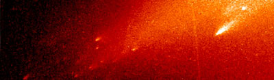
The Deep Impact mission to comet TEMPEL 1 showed the head of that comet to have the consistency of a dirty snow bank. It also showed that the object is a geologically active body.


Comet HOLMES is unstable, and prone to violent outbursts. And if we look at the recent HST images shown above of the fragments of Comet LINEAR we clearly see that explosive fragmentation of an icy comet can occur spontaneously before it even gets close to a planet.


It doesn't need the atmosphere to do that. It's been more than a hundred years since the Tunguska phenomenon. And the Russian scientists haven't been sitting on their hands all this time.


There are literally hundreds of excellent, peer reviewed, papers on the subject. The explosive cosmogony of comets has been exhaustively studied, and thoroughly described. (E.M. Drobyshevski)


So the nature of those explosions is understood better than most realize. And It should be noted that for decades we have continued to look for the planetary scaring of normal ballistic/kinetic impact events like we see on the moon. And yet, the only large ET impact in recorded history was a thermal explosive airburst event.

Mark Boslough, at Sandia Labs has done a super computer simulation (below video) that depicts the atmospheric effects of an above ground blast like Tunguska but much larger.


It shows the object exploding high in the atmosphere. But it retains it's momentum.


And, in a moving explosion, all of the kinetic energy continues on down to the ground in the form of a supersonic downdraft shock wave hotter than the surface of the sun.

For comparison, an ordinary oxy-acetylene cutting torch in a steel shop uses a thin stream of hot gases at only about 1600° F and 40 PSI to cut steel. The speed of that stream of hot gasses is only a little bit more than a stiff breeze. But that's all it takes to turn solid iron into a melted, aerosol spray. And to blow it away in runnels of melt into heaps of slag.


The nano-diamonds in the YDB are significant in that they formed under hot, violent, explosive, atmospheric conditions all over the north American continent that should have been able to do that to whole mountain ranges. Those conditions of intense heat, and pressure can only happen in an impact event. And yet no one has ever found a crater.


But that much heat, and pressure, only goes away peacefully in children's bedtime stories. So, since the surface scars the impact firestorm made must be here right under our feet, then maybe the pretty, perfect circle, craters we see on the Moon, and Mars, and that we’ve come to assume we should expect here on Earth as well, aren’t what we should be looking for at all.


But if we’re not looking for round craters, then what kinds of planetary scaring are we looking for?

More, and more, reliable evidence is coming to light that tells us very clearly that we should be looking for signs of non-volcanogenic melting instead of craters. But the conundrum we face now is that we have always assumed that the only source of enough heat, and pressure to melt rock is below ground. Or in a large ballistic impact event.


Generations of Geologists have used melted rock formations, and metamorphic rock, as conclusive evidence of volcanism, or plate tectonics.


They would hold up a piece of melted rock. And, recognizing that its chemistry could only have been produced under conditions of intense heat, and pressure, and believing that those conditions could only be found deep in the Earth, have coined generic terms like "Deep Crustal", or "Upper mantel", to describe them.


And the number of confusing, wrong-headed, theories for getting sedimentary rock down to great depth, cooking it enough to turn it into metamorphic rock, and then bringing it back up again without any deformation of the strata are to many to count.

The differences in the chemistry between impact blast melt, and ordinary volcanic tuff may be so small that only detailed laboratory analysis can tell them apart.


And visually, they may be virtually indistinguishable to one standing on the ground among them. But there is a better, far simpler way to tell them apart. If you want to study an explosive event after the fact, you look to the actual motions of the blast effected materials.


It's as simple as asking:

  • Which way was it moving before it came to a stop?

  • Was the flow pushed from behind by pressure?

  • Or was it pulled from the front by gravity?

  • Where did it flow from?

This is a profoundly simple hypothesis founded on the principle that we can answer those basic, fundamental questions easily, and confidently, with hi-resolution satellite images.

There is a huge debate looming on the horizon. Because, in fact, many of the melted rock formations produced in the Younger Dryas impact event are very easy to identify, almost conclusively, with satellite images alone.


And without exception, every one of the positively identifiable ET blast melt formations will be found to have already been misidentified as volcanogenic.


The Chihuahuan Ignimbrites

Ignimbrites, literally "fire cloud rock", or tuff as they're more commonly called, are the stuff you see in the satellite images of central Mexico that has the look of wet, fast flowing, concrete, or lumpy mud.


The patterns of motion in the Chihuahuan desert ignimbrites are all consistent with very fast motion like ejecta. And, volcanogenic, or not, ignimbrites are always formed, and emplaced, in an explosive event. So, as a blast effected material, they are always a clear, and direct, signature of the fluid motions of the explosive events of their formation, and emplacement.


There is no need for theories as to the origins, and material movements, when those actual movements are easily discernable, empirical fact. We don't need to guess how it formed, and flowed, during emplacement, when we can clearly see how it actually moved. And where it moved from.

Before, there were only two recognized forms of "tuff", or ignimbrites. We had volcanic tuff, and we had impact melt.


But we need to break it down further into a third category.

The three are:

  1. Volcanic tuff - produced in a volcanic eruption.

  2. Impact melt - produced in a ballistic impact of a solid bolide.

  3. Blast melt - produced in a Tunguska class, thermal explosive event.

Our focus is on the last of the three.


This work is simply an ongoing study of the fluid motions of those ignimbrites. The sudden, unimaginably violent events of their formation can be understood to an amazing, and extraordinary, level of detail if one simply studies how the blast effected materials moved during emplacement.


So the only questions I am asking here are concerned with simply: How did it move, and flow?


We need only to get enough altitude to see the actual patterns of flow, to determine the exact movements, and true points of origin, of a sheet of surface ignimbrites. So the science of Fluid Mechanics has the trump card. And it doesn't get any easier than when the materials are in pristine condition, on the surface.


I would have thought that the geology of the north American continent was all very well studied. But when you start looking for any detailed research on emplacement of the surface ignimbrites in central Mexico, and west Texas, and the exact nature of the explosive events they were formed in. You quickly find that, while there are quite a few untested theories, detailed studies of it's origins, and emplacement, haven't been done.


But by understanding the motions, and fluid dynamics of the ignimbrites, and other blast effected materials, in the region we can come to a true understanding of the nature of the explosions they were formed in. The truth is clearly written in stone for all to see. We need only to get some altitude, and a little distance, in order to read it.

The mountain you see here is 5 miles long.

It is surrounded by a radial, out wards flowing, splash curtain of ignimbrites like an ejecta curtain.

The mountain is clearly, and obviously, the source location for the radial out wards splash curtain of ignimbrites. But the mountain is not a volcano. It consists of uplifted meta-sedimentary rock. And there is no vent there. So it is not the source of heat, and pressure that melted, and moved them.


There are only two possible directions look to for enough heat, and pressure to melt a few cubic miles of the Earth's surface and to blow it away from its source. Since we can clearly see the ignimbrites didn't come out of the mountain. But were blown off of it, and away from it. We can rule out down.

The heat, and pressure came from above.

Click here for an 8.5 meg high resolution image

with the mountain in context with its surroundings.
 

I have been told that "most Geologists agree" that these ignimbrites were deposited in the so called Mid-Tertiary Ignimbrite flair up between 25 and 40 million years ago. Such an ancient date for the emplacement of these ignimbrites can't be supported.

The geochronology of the north American continent is still very poorly defined. And if we accept that the state of the science is expressed by the USGS's own Geochronological data-base, it just may be that we don't have the technology yet to accurately date this event. When I downloaded the database what I got was a huge spreadsheet in Microsoft Excel format with most of the cells left empty.


They explain the empty cells with the disclaimer that they haven't included any of the anomalous data.


And there aren't any entries for anywhere on the continent in the "age since melt" column...

They give no explanation of what they consider to be "anomalous data". And without such an explanation I have to consider that either most of their assumptions are wrong, or most of their data is questionable. And without free access to the whole dataset, warts, and all, I remain to be convinced of the validity of any of it.

But if we want to pretend, and maintain, that there was a vent there that the ignimbrites erupted from 25 million years ago, and that they, and the mountain they came from, have undergone so many millions of years of exposure to the elements, then the ignimbrites need to show a considerable amount of hydrologic decomposition. There should be nothing left of them but soils.


And they need to be under 25 million years worth of alluvium from the erosion of the mountain. Instead, they are on top of everything else. And we see virtually no alluvium from the mountain at all. Only the mountain, and its radial curtain of ignimbrites, slightly dusted with wind born sediments.

The ignimbrites of the Chihuahuan desert, extending all the way up into west Texas, and New Mexico are on top of every thing else in perfect condition. They are the pristine capstone of the geologic column. And with the exception of that tiny amount of wind blown silt, and the occasional sage brush, this terrain did not look much different when the ignimbrites covering it were still hot, and smoking, the day after the event they formed in.

The mid tertiary ignimbrite "flair up" is a confabulated, event. And if you take a typical paper on the "Mid Tertiary Ignimbrite Flare Up" and you line out all of the untested, assumptive reasoning, there is nothing left.

Impact melt, and ejecta, is often misidentified as volcanic tuff. But wherever you find such material, volcanogenic, or not, and no matter what the source of heat, and pressure that melted, and moved it, you can know that it formed in a violent explosive event and was moving very quickly before coming to rest, and solidifying.


And unless the material has completely decomposed into soils, and become covered in vegetation, you can look at a flow of it, and easily see which direction it was moving at any particular point. And in a hi-resolution satellite image the motions of the ignimbrites in central Mexico, and those in west Texas, are as easy to read as the patterns of movement, and flow, in splashes of spilled paint.

The movements of an unconstrained fluid are defined by the forces moving it.


And for our purposes we'll need to refine that profoundly simple observation a little more and say that there are two fundamental forces to consider; gravity, and pressure.


Examples

Take a droplet of paint, and put it on a level surface.


Then blow it around with a straw. That's a pressure driven fluid. It's characteristic patterns of movement, and flow, are the result of the motive force being behind the flow, and pushing it. It piles up at the low pressure areas on the periphery where the pressure is no longer strong enough to move it.

Next, tip the surface a bit and let the paint flow downhill. That'll be a gravity attracted fluid. Its patterns of movement, and flow, are consistent with the motive force being in front of the flow, and pulling it down hill. It doesn't work on level ground.

The lines of flow in an unconstrained, and driven fluid will always be away from the driving force. Even if that fluid is melted stone being driven up hill.


And when those lines of flow are frozen into a river of melted stone they become a permanent, reliable record of the nature of the forces that melted, and moved it.


An experiment

Cover a surface with about an inch of wet, slightly sticky, grainy, mud the consistency of thin, wet, concrete. Hit it with short bursts of compressed air coming down from above to simulate the patterns of movement, and flow, in a pressure driven flow of blast melt.


A fun variation, if you want you involve children in the experiment, is to use runny oatmeal spread out on a cookie sheet. If you have the kids surround the Cookie sheet, and blow the oatmeal around with short, random, puffs of air thru a straw. You get the same flow patterns.


But the kids taught me one should be vigilant, and use caution with this version of the experiment due to the danger of the experiment escalating into a food fight. If you look away at the wrong time you could become the first casualty. It was a good learning experience for all though. The kids easily learned what the flow patterns of a pressure driven fluid look like.


And I've learned that it's difficult to do good, objective, scientific, observation with oatmeal in your ear.

You can mock up a classic science fair scale model of a volcano if you want to simulate the flows of a gravity attracted density current down slope.

The form of the mountain above is not the result of millions of years of erosion. The product of which would be alluvium. The mountain's form is the result of instantaneous ablation from above. The product of which is the radial out-splash curtain of pressure driven ignimbrites.

In an explosive volcanic eruption we see both gravity, and pressure at work as the material is ejected from the vent forcefully, only to be attracted by gravity down, and away from the vent. And it rarely flows very far.


But we see something different going on in central Mexico, and west Texas.


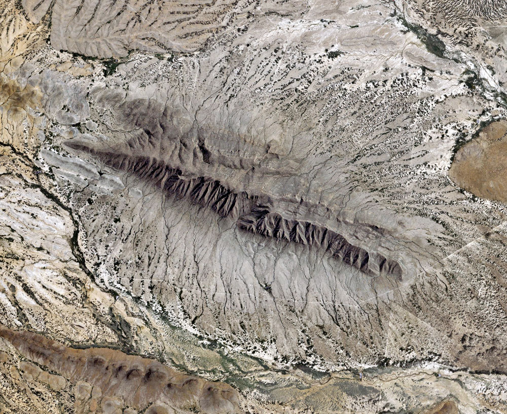
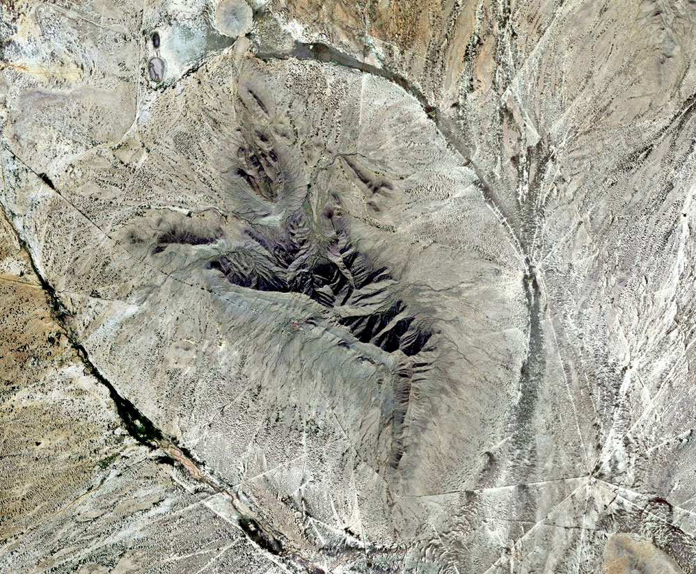
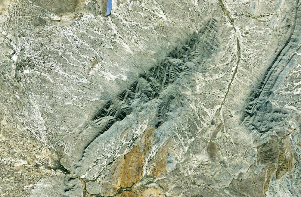
There are tens of thousands of square kilometers of pristine ignimbrites, with no visible signs of decomposition, at the very top of the geologic column. And when you spend some time studying the movements of the blast effected materials in the satellite images, you'll notice something that generations of Geologists on the ground missed.


The patterns of movement, and flow are not consistent with a volcanic eruption at all. All of the material movement is pressure driven. And there aren't enough volcanic vents to account for even a fraction of all of the melted material. And, because of the scale of it all, you don't see it until about twenty thousand feet. But the simple, observable, fact is that, contrary to the old literature, the melt didn't come out of the ground in a so called ignimbrite "flair up".


It was the original surface terrain, blasted, and flash melted, by multiple sources of heat, and pressure coming down from above.


The material was blown off its source locations by those same above ground sources of heat, and pressure.

Click on the image for an enlarged view.

Or if you'd like to see a wider perspective with this place in context with its surroundings

click Here for a 4.5 meg PDF copy of the image.
 

The Sandia Lab's simulation (above video) didn't hazard a guess as to the resulting ground effects.


But it is a fair assumption that instead of being smashed and recycled into a nice round ballistic impact structure, when the hyper thermal, supersonic, downdraft hits, the terrain below it quickly and violently just melts, and goes away like wax under a blow-torch. (Or like oatmeal away from a straw)


We can logically predict that such an event should create a bare, ablated looking area or mountain surrounded by ignimbrites, and melted stone, flowing away from the blast epicenter.

The patterns of movement of the pressure driven, blast effected, materials are a proxy map for the atmospheric conditions above them.


The blast melted rock settled into the low pressure areas after being flash melted, and blown off its points of origin. It can't get any simpler. Look closely. The lighter, smoothly melted stone marks the locations of the individual blast points and areas of highest heat, and pressure that the ignimbrites were driven off of.

Standing on the ground among those rocks, they are indistinguishable from ordinary volcanic tuff. Their true nature is only obvious from high altitude.


It is only then that the words "volcaniclastic", or "volcanogenic" are revealed to be inappropriate.

Volcanism had nothing to do with this.


The parent material of the ignimbrites, or "tuff" as it is more commonly known is the original terrain. This melt was flash melted almost instantly. And blown down and away by downwards blasts of heat, and pressure from above. It's motion was almost instantaneous. Click on the above picture to zoom in closer. Pay particular attention to the patterns of movement, and flow, of the blast effected materials in the image.

Note that the ignimbrites are splayed out around the central peak in chevron shaped splashes like ejecta curtains.

The central uplift is all uplifted meta sedimentary rock. Not an eroded volcanic plug. Look closely, there is virtually no alluvium, or other products of exfoliation, or deterioration, of rock that we should expect if the surface of this terrain were millions of years old.


Therefore the formation, and emplacement of the ignimbrites, is the most recent significant event in the geologic column.

Along the left edge, we see two impact structures with radial fracture patterns like rock dings in a window pane. And we can tell by the patterns of movement in the blast effected materials that the objects impacted into still melted, not yet hardened, ignimbrites.

Ignimbrites blown outwards from a central uplift of meta-sedimentary rock such as you see here is ordinary-typical for most of the Chihuahuan Desert.

There has been some mapping of ignimbrites in the Chihuahua City area and on northward for about 100 km, or so, in spots along the Chihuahua-El Paso highway. It's taken years to get just that little bit done. But there is more than 40,000 square kilometers of pristine, random-colliding rivers of fast flowing ignimbrites in central Mexico, and up into west Texas that look like they only just cooled yesterday.


Waiting a lifetime for those geologists on the ground was not an option. And in frustration because I couldn't get my hands on any decent research papers on the subject.


I set out to work out the patterns of movement in the flows of tuff in north central Mexico for myself to get a better picture of the explosive events they formed in.

If it takes months, or years to map a few miles along a highway from the ground it's time to bring the work into the twenty first century and use the satellites our tax money paid for, and do it from space, or it'll never be finished.


Thanks to NASA, Landsat, and Google, I can produce my own image map of any given area on the continent in full spectrum color with resolution down to 1 meter per pixel. And computer memory is the only constraint to size. I have a couple I've had printed professionally that cover a whole wall. If you look at a specific location anywhere in those flows it is very easy to see which way it was flowing at any given point. And backtrack it to its source location.


A sheet of clear plastic, and a handful of markers, and you have a large area, hi-resolution flow map. Complete with little directional arrows.

Structure like this are pretty ordinary. And to one-to-one standing on the ground among those rocks who is well versed standard geology theory the assumption would be that the mountain was eroded to its present form over millions of years.

But let's look at that assumption little closer.


The radial ignimbrite curtain surrounding the mountain consists of perfectly pristine, pressure driven, ignimbrites. And the pointed chevron patterns of movement frozen into the ignimbrites at the time of their emplacement are consistent with sudden, and violent, motions like an impact event.


And the teardrop shaped ring fracture in the bedrock begs many questions of its own.


As with the mountains above, if the mountain were an ancient, eroded cinder cone of an eruption that produced the ignimbrites millions of years ago, that erosion should have buried the ignimbrites long ago under gentle rolling hills of alluvium, and sedimentary deposits.

The simple, profoundly observable, empirical fact here is that the landforms in this region were not eroded by a gradual process of decomposition requiring millions of years. They were heavily ablated from above in a violent explosive process that only took seconds. The Ignimbrites are the resulting blast effected materials.


And they are a direct, and clearly legible signature of the fluid motions of that explosive event.

There are gaping holes, and glaring discrepancies, in the data when it comes to the actual movements from it's assumed sources, and final placement.


There simply aren't enough vents. And you can't say it came from one direction if it was flowing the other. Those actual material movements tell an extraordinary story. One that is far different from anything we ever imagined. It's abundantly clear that, sometimes, large scale surface melting can happen in a multiple air burst, thermal, impact event.


And even though there may be no evidence of shocked minerals, we need to replace those generic terms of "deep crustal" and "upper mantle" with the actual temperatures, and pressures, the ignimbrites formed in.

The standard theory is that these materials were produced in multiple events over a period of millions of years. But any given fragment of ignimbrite, no matter the scale of the event it formed in, was only in fluid state on the surface for a few violent seconds at most. Even in a super eruption that goes on for days.


So if two flows of melted stone are representative of two separate events, even a separation of only a few seconds, then one of them will be seen to be over-topping the other, already solidified one. But if they were both melted, and flowing at the same time, the interaction between the two will be a fluid convergence. i.e.


They will inter-finger. Or they will come together like two rivers flowing into one.

Everywhere, in all of the tens of thousands of square kilometers of random, colliding, flows of ignimbrites in central Mexico, and west Texas you'll note that, without exception, the patterns of movement in all of the materials are consistent with very fast, and sudden, motion like ejecta. And every collision between flows is a fluid convergence.


There is not one single over-topping flow. The inescapable conclusion is that contrary to the old literature, all of the pressure driven ignimbrites in the Chihuahuan Desert were in rapid, fluid, motion at the very same time. All of that tuff describes an intricate, almost infinite, dance of violent fluid motions. And all of those turbulent, inter-flowing, motions describe the very same moment.

Here are the possibilities:

  • Either that material is the geologically recent result of the largest super eruption since primates first came down out of the trees. And most of central Mexico is one giant, explosive, caldera that no one ever noticed as such. And all of the missing vents will be found... someday. (And never mind that the simultaneous, inter-flowing, mega-flood of melted stone describes a sudden, virtually instantaneous, event.)

  • Or all of the melt is the result of the most violent ET encounter in 65 million years. And it, and its ground effects, are different from anything ever studied before.

Both are pretty extraordinary possibilities.


The visual evidence is more supportive of the latter. But no matter what the source of the heat, and pressure that melted ,and moved it, the more than 40,000 km2 pristine, simultaneous, random-colliding, inter-flowing, rivers of blast-generated ignimbrites, at the pinnacle of the stratigraphic column describes a geologically recent explosive event that was arguably the single most violent natural disaster in all of human existence.


Yet, with the exception of a few prospectors looking for money rocks, it's almost completely unstudied.

Our impactor appears to have been a large, highly fragmented, and loosely grouped, cluster, about 500 km wide, like a giant, flying gravel pile. Except that much of the material was highly explosive in its own right. (E.M. Drobyshevski)


The comet would have looked like a sister to the images of the fragmented comet Linear you see here on the right. It came in at very high velocity, and low angle of approach from the southeast. And almost all of the fragments exploded above ground like Tunguska.


Except that, in Mexico, only the very first of the fragments on the leading edge fell into cold atmosphere. The rest fell into already super heated impact plasma, and just added to the heat. The primary impact zone is a 500 by 1300 km oval that covers most of central Mexico. And extends well up into west Texas, and New Mexico.

All of the available literature assumes the sheet ignimbrites in the Chihuahuan desert to be the result of ancient volcanism millions of years ago.


But there is no such thing as immortality. Even the rocks of the Earth crumble to dust after a few million years of exposure to the elements. And those tens of thousands of square kilometers of perfectly pristine ignimbrites, on the surface, and at the very pinnacle of the geologic column are most certainly not thousands of times older than the stones in the monuments of the Nile.

If an extraordinary hypothesis requires extraordinary proof all I can say is look closely, and see for yourself.


There is no visible trace of exfoliation, or decomposition, in the Chihuahuan ignimbrites at all. And except for some sparse cacti, and sagebrush, growing on them, those flows of ignimbrites are all in the very same condition as the day they first cooled.


And their motions are very easy to read.
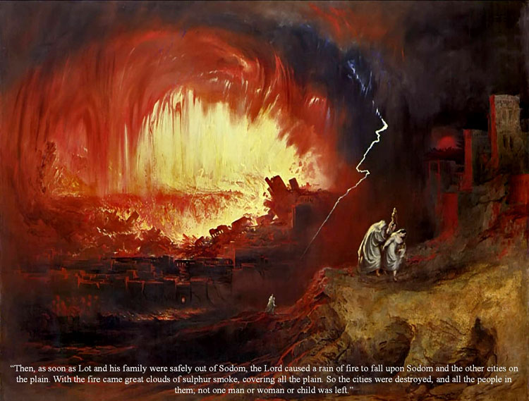


Excerpts from...

"Different Kind of Catastrophe"
by Dennis Cox

December 28, 2009

from TheMilleniumGroup Website


...The atmosphere translates all of the kinetic energy into heat. But it doesn’t dissipate it.


And contrary to standard impact theory, the most common forces acting on the ground in an airburst impact event are heat, and pressure, not kinetic shock. The reason that round craters are rare isn’t because we rarely get hit. They are rare because we rarely get hit by non-explosive rocky bolides, or asteroids.

It turns out that the Tunguska object was only rare in that it arrived alone.


And it was such a puny little thing. A large, highly fragmented comet consisting mostly of ices that are almost as violently explosive as hydrogen peroxide rocket fuel is a much more frightening kind of monster; and much more common. The form the planetary scaring takes is characterized as a non-volcanic melting event hot enough to make stone flow like water for a moment. And ballistic/kinetic shock has almost nothing to do with it.

An in escapable fact that can not be ignored is that the most violent natural disaster, and extinction level impact event, in 65 million years was only a few thousand years ago. We have the burned bones of the extinct animals for proof.


But standard uniformitarian, gradualist, landform theory is in complete denial of the geomorphology of the event. The high priests of the Church of the Uniformitarian Confabulation would have us accept on faith alone that such a thing can happen. That it is possible for an extinction level event to kill all the life on half a continent, severely compromise the food chain in the rest of it. And then leave no geological trace.

Impact science is very poorly understood. A fact readily acknowledged by most competent impact scientists, and grad students. But hotly denied by the freshman class. And by folks who get their science from the discovery channel. This was a very different kind of impact event . It was caused by the impacts, and detonations, of objects different from anything ever studied before.


And they produced planetary scaring different from anything ever imagined before. The claim that looking for the markers of a normal impact didn’t turn up evidence of this one. is like saying they tuned their search to detect the tiniest trace of oranges, and they didn’t find any evidence of apples.

For me, the trail started in Mexico. And the ignimbrites of the Chihuahuan desert. Impact melt is often misidentified as volcanic tuff. But whether volcanogenic or not the word “ignimbrite” meaning fire cloud rock is still appropriate. Until now The patterns of movement, and flow of the Chihuahuan ignimbrites in central Mexico have never been studied.


And except for a small along a stretch along the highway between Chihuahua City, Mexico, and El Paso, Texas, they are completely unmapped.

My work is simply an ongoing study of the fluid motions of those ignimbrites.


The sudden, unimaginably violent events of their formation can be understood to an amazing, and extraordinary, level of detail if one simply studies how the blast effected materials moved during emplacement.


***


I’ll quote Bill Gates and tell you “that is the stupidest thing I have ever heard."

And then there is the lack of enough volcanic vents to account for 40,000 square miles of ignimbrites. You can’t say it came from one direction if it was flowing the other.


And the proposed trap door rift vents that simultaneously open, spew a few thousand cubic miles of ignimbrites, and then close without a trace involves some crazy mantle physics that would only make sense to a 5 year old fan of Dr Seuss. And just isn't possible in the real world. As a matter of fact, if you take a typical paper on the “Mid Tertiary Ignimbrite Flare Up” and you line out all of the untested, assumptive reasoning, there is nothing left.


So the mid tertiary ignimbrite “flair up” is a confabulated, mythical event that did not happen.


***

If it takes months, or years to map a few miles along a highway from the ground it’s time to bring the work into the twenty first century and use the satellites our tax money paid for, and do it from space, or it’ll never be finished. Thanks to NASA, Landsat, and Google, I can produce my own image map of any given area on the continent in full spectrum color with resolution down to 1 meter per pixel. And computer memory is the only constraint to size.


I have a couple I’ve had printed professionally that cover a whole wall. If you look at a specific location anywhere in those flows it is very easy to see which way it was flowing at any given point. And backtrack it to its source location. A sheet of clear plastic, and a handful of markers, and you have a large area, hi-resolution flow map. Complete with little directional arrows.

***


Any given fragment of ignimbrite, no matter the scale of the event it formed in, was only in fluid state on the surface for a few violent seconds at most. Even in a super eruption that goes on for days. So if two flows of melted stone are representative of two separate events, even a separation of only a few seconds, then one of them will be seen to be over-topping the other, already solidified one.


But if they were both melted, and flowing at the same time, the interaction between the two will be a fluid convergence. i.e. they will inter-finger. Or they will come together like two rivers flowing into one.

Everywhere, in all of the tens of thousands of square kilometers of random, colliding, flows of ignimbrites you’ll note that, without exception, the patterns of movement in all of the material is consistent with very fast, and sudden, motion like ejecta. And every collision between flows is a fluid convergence. There is not one single over-topping flow.


The inescapable conclusion is that contrary to the old literature, all of the pressure driven ignimbrites in the Chihuahuan Desert were in rapid, fluid, motion at the very same time. All of that tuff describes an intricate, almost infinite, dance of violent fluid motions. And all of those turbulent, inter-flowing, motions describe the very same moment.

***


The thing would have looked like a sister to the images of the fragmented comet Linear.


It came in at very high velocity, and low angle of approach from the southeast. And almost all of the fragments exploded above ground like Tunguska. Except that, in Mexico, only the very first of the fragments on the leading edge fell into cold atmosphere. The rest fell into already super heated impact plasma, and just added to the heat.


The primary impact zone is a 500 by 1500 km oval that covers most of north central Mexico. And extends well up into west Texas, and New Mexico.

In New Mexico at the northern edge of the primary impact zone there are crater fields with too many craters to count about the size of a football field. They are on the other side of the state from any ordinance testing. And they are described in the maps, and literature simply as “enigmatic depressions”….


Let’s see, perfectly round, punched into the surface from above, yep! pretty darned enigmatic to me.


But only if you don’t believe in giant, geologically significant, multiple fragment, thermal impact events.

I’ve also cataloged more than 700 non-standard impact structures that are more consistent with the hot, and powerful, surface detonation of a shaped thermal explosive charge than anything from we thought we knew about impact events, or possible compositions of bolides.

Depending on the strength of the surface, and the size of the detonation. The blast burns grade from a deep, thermal burn. To a full fledged crater. And they are square. That’s right, I said square. with a capital “S” square. No two are exactly alike. And the ones that only show a thermal blast burn without excavating a crater make it clear that the square shape is a product of the detonation burn pattern. Not the result of patterned fracturing in the surface rock.

Here are links to the image set of square blast burns, and craters, in roughly 100 image, gallery segments, as well as a few ordinary round ones. They are in no particular order, as they were saved pretty much in the order they were found.


There may even be a duplicate here, and there.


And this is by no means a complete inventory of them.

I’m still hoping for a seasoned physicist to weigh in on them. So share them around as you see fit.

As far as I can determine, there is no standard theory that can account for the square detonation shock patterns most of the images describe. They are a wonderful conundrum.


Although, they can be plausibly explained by recent work into the Tunguska phenomena by E.M. Drobyshevski.