|
Italian
version Adobe Stock
Some of these tribes have
seen glimpses of our modern society, and their behavior after coming
in contact with other humans showed they wanted to be left alone, a
wish one should respect.
Because of its ability to capture extraordinarily accurate, high-resolution, 3D data LIDAR (Light Detection and Ranging) has become an appreciated tool among archaeologists.
LIDAR has been used to find lost ancient cities, pyramids in the South American jungle, and other structures that are obscured by dense and protected vegetation.
in the Brazilian state of Acre. Credit: Gleilson Miranda
Governo
do Acre / Wikipedia The list of archaeological discoveries made with help of LIDAR is long. Archaeologists were amazed when they used LIDAR and discovered more than 60,000 ancient Maya structurest obscured by inaccessible fores.
The use of jungle-penetrating technology that can pierce through the thick forest canopy and map features on the Earth’s surface has proven to be indispensable in some cases.
In North America, satellite researchers discovered several hidden North American mounds that could offer valuable information about pre-contact Native Americans and early life of our ancestors.
When Polish researchers used LIDAR they discovered an unknown 2,000-year-old settlement hidden in the Tuchola Forest.
The use of LIDAR in Brazil. Credit: University of Exeter
We can go on and give many more examples of how good LIDAR technology can be to archaeologists, but the list would be too long.
Suffice to say a new interesting archaeological discovery has been announced by scientists who understood the value of LIDAR.
LIDAR technology has revealed 35 ancient villages hidden in the Amazon Jungle. Credit: University of Exeter
Recently we reported never-before-seen Amazon rock Art reveal people lived with giant Ice Age animals and now it's time for yet another discovery from this region.
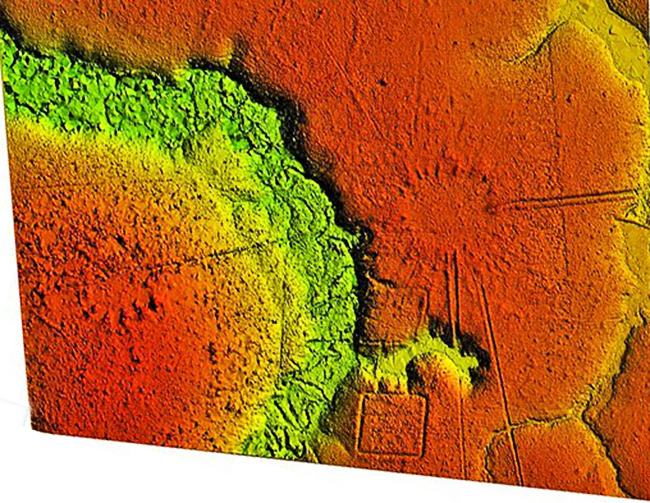
Remote sensing equipment mounted onto helicopters in south Acre State, Brazil has revealed an ancient landscape of mounded villages built between 1300 and 1700 AD.
These ancient Amazonian villages are different because of their clock face layout.
The distinctive and consistent arrangement of the circular villages suggests the ancient Acreans had very specific social models for the way they organized their communities, potentially organizing their dwellings to represent the Native American cosmos.
Native American cosmos beliefs vary from tribe to tribe, and since we possess extremely little information about the Acreans in Brazil we can only speculate about their views of the world and Universe.
This discovery offers however further evidence the rainforest has long-been occupied by indigenous communities, whose cultures rose, fell, transformed, and rose again, long before Europeans made an impact in the Americas.
The research, conducted by an international science team shows after the abandonment of the large geometrically patterned ceremonial earthworks, around AD 950, a new culture arose with communities living in mounded villages with highly defined concepts of social and architectural space.
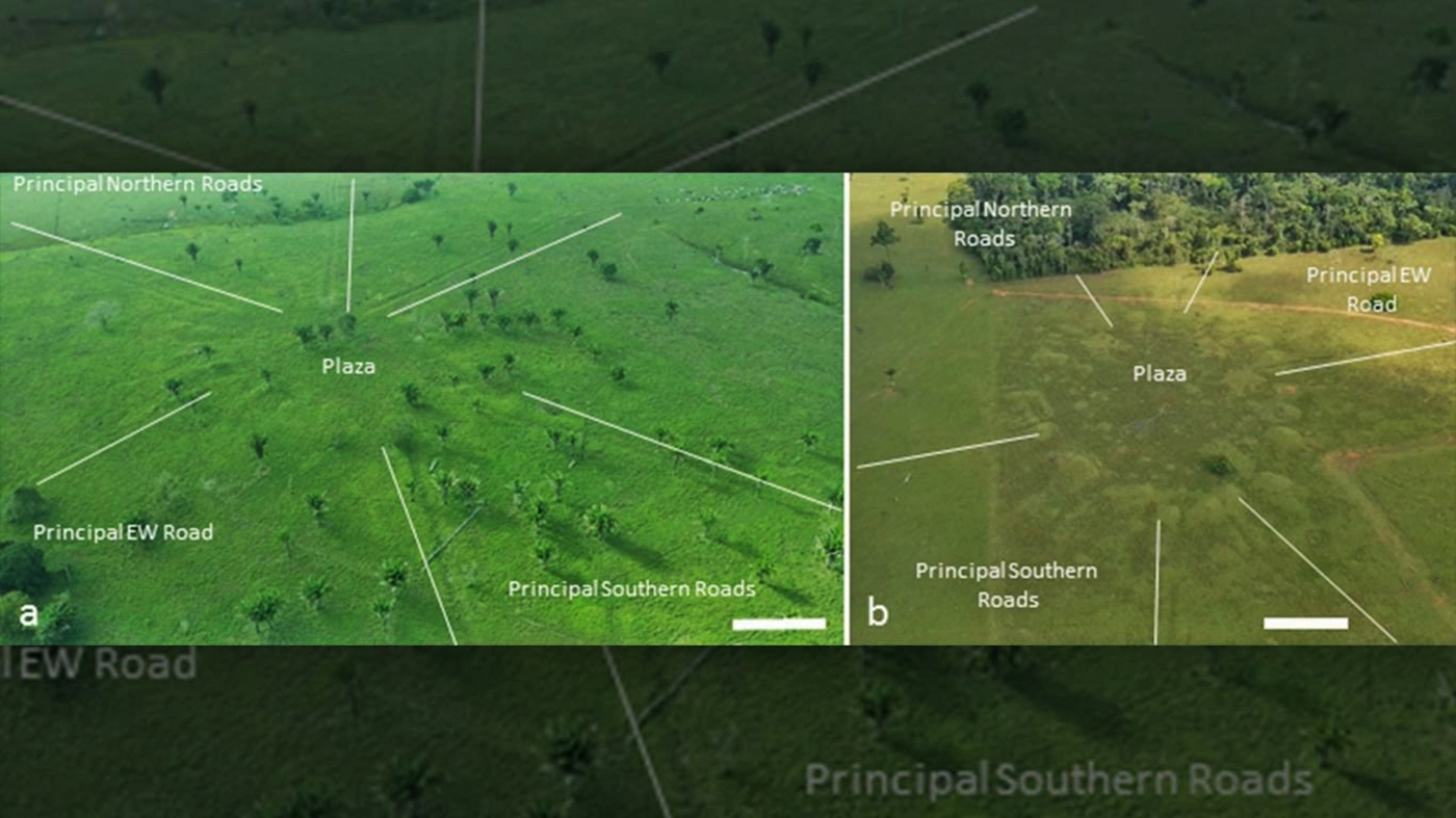
The circular mound villages are connected across the wider landscape through paired sunken roads with high banks that radiate from the village circle like the marks of a clock or the rays of the sun.
The villages have both minor roads and principal roads, which were deeper and wider with higher banks.
Credit: University of Exeter
Most villages have paired cardinally orientated principal roads, two leaving in a northward direction and two leaving in a southward direction.
The survey reveals that the straight roads often connect one village to another, creating a network of communities over many kilometers.
Deforestation in the region had previously revealed the presence of large geoglyph earthworks on the landscape with archaeological research also documenting the presence of circular mound villages.
However, until now the extent of earthwork constructions, their architectural layouts, and their regional organization remained hidden beneath the remaining dense tropical forest.
Over 35 villages and dozens of roads were documented in the research with many more predicted to still be hidden below the unexplored jungle.
The villages were composed of 3 to 32 mounds arranged in a circle, the diameter of which ranged from 40 m to 153 m with the area enclosed by the central plaza ranging from ~0.12 to 1.8 ha.
The arrangement of the spotted ancient villages is interesting because these round patterns may have been a reflection of how ancient Americans perceived space as circular, with stellar constellations moving around the Earth.
|