|
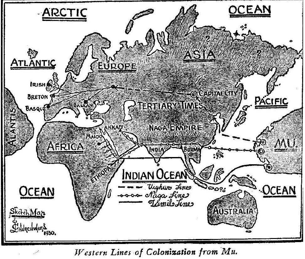
The Uighur Empire was possibly the first, and unquestionably the largest, most important, and most powerful, of all the colonial empires belonging to Mu.
A short independent line was carried out to the Malay Islands by a people known as Quiche Mayas.
The color of
the Quiches varies more
than that of any other race of man, from a white to a dark brown.
They appear to have joined several lines of colonists from the
Motherland for they are found in Central America, South America,
South Sea Islands and the Malay Islands. The Japanese are one of the
branches of the Quiches.
In archaeology a single discovery is only a link and
should be treated as such until the next link is found and attached,
and so on until the complete chain is forged. Speculations, as such,
are not only admissible but valuable, but deductions stated as
facts, emphatically no. These errors are prominent in various
archaeological writings.
The Karangs in Java, through their religious rites and ceremonies, clearly show that their forefathers came from the Motherland.
This is tradition verified.
Very little is known about Ancient Burma.
Apparently it included the whole of the Malay Peninsula and lands to the north and east, of it. Traditions state that when Ancient Burma existed the southern coast lines were not as they are now, that lands have been both submerged and emerged. Burma was the first stopover place of the Naga line of colonists. Burma is composed of two vocables of the mother tongue and means The New Land.
The Nagas took their name from
their symbol for the Creator-Naga, the Seven-headed Serpent.
The name of the ancient city in the Motherland from which the Nagas sailed was called Hiranypura.
The remains of this city are to be seen to this day on one of the Caroline Islands due east from Burma. The first Naga-Maya settlement in Burma was of an exceedingly ancient date. Tablets in the Himalayan monasteries, relating to the first settlement of Uighurs just north of Burma, state that colonization commenced more than 70,000 years ago.
The first history that we know about Burma commences only a thousand or fifteen hundred years ago, but remains of ancient cities are found in Burma and Valmiki's writings confirm a very ancient date.
Modern Cambodia is a part of Ancient Burma.
The great river Meikong runs through the center of it. Along this river and its branches are a great number of remains of ancient civilizations. Whether any of them belong to the first civilization is still an open question. The bulk of them, however, date back only to about 1400 to 1600 years ago. This is fairly well authenticated by research work and excavations by French archaeologists.
At Angkor are some wonderful remains which are now claiming attention from the world, for while the bulk of them are apparently not of a very ancient date, their magnificence is unsurpassed by any architecture in the world. The French archaeologists, who have been studying these ruins, tell us that there have been three eras in their building.
The last one was subsequent to the 7th Century A.D. The preceding one has been called the Khimer architecture which ended during the 7th Century A.D., and back beyond the Khimer is a third erected by an unknown people. These may be the works of the first civilization. I do not know and cannot say without first examining the ruins and reading the inscriptions on the stones, if there are any.
The carvings on these stones, judged from photographs only, seem traceable to the ancient Maya of Yucatan and Central America. The most notable structure is at Angkor Vat. It was built during the time of the Khimers and finished during the first half of the 7th Century A. D.
It is one of the most wonderful structures in the world and contains 1025 yards of sculpture, with hundreds of thousands of figures.
In Hammerton's Wonders of the Past, Vol. 1, appears an article by Edmund Chandler from which the following extracts are taken:
Chandler says, "leaving no trace." While they have left no trace, nature has.
Again Chandler asserts that they were "Serpent
worshipers." They were not as I shall hereafter show.
I will further quote Chandler:
This comes from the Hindu epic, Rama and Sita:
Conditions at Angkor Thorn do not warrant the dates fixed.
Chandler states that Angkor Thom was the capital of the Khimer Empire and that the buildings are of "very much earlier date" than Angkor Vat. The Khimer Empire lasted only about 200 years. There is no margin here for saying "of very much earlier date."
Chandler's "grotesque goddesses" are sacred symbolical figures telling a tale or recounting history.
The serpent rising out of a tank of water is one of the ancient symbols for Creation.
This is a symbolic building, the four faces point to the four cardinal points - the Sacred Four ruling and governing the material universe. Details of the carvings on this shrine would enable me to give the whole tale.
The origin of the Khimers is clearly and accurately told by the
histories of nearby lands. Beyond this Fournereau has clearly
established their land of origin as India.
The details given by Madam Candee are so minutely given as to be of the greatest value to the archaeologist. The book is charmingly written.
I shall take only one quotation from this work:
Madam Candee is quite correct when she says Naga is a symbol, only she has not placed the symbol high enough. It is not intended for a demi-god but for the Great Creator Himself.
An inscription in the temple reads,
A close examination of the carvings on all of the structures at Angkor show them crying out:
The royal lotus, the symbolic flower of Mu, is profusely used in the decorative carvings.
The trident, the royal scepter of the Empire of the Sun, is prominent. The head dresses of many of the figures carry the numeral symbol of Mu. All buildings except the last at Angkor Vat face the east, the direction of the loved and revered Motherland. Conventional figures, called by the French archaeologists "lions," appear prominently.
They are in
rising positions and all face east. Their mouths are formed by the
letter M (see page 34) of Mu's hieratic alphabet. M was the
alphabetical symbol of Mu.
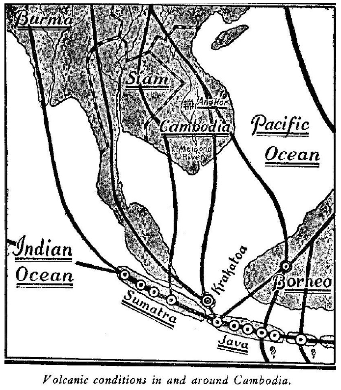
The manner of the sudden disappearance of the Khimers is more than suggested by consulting the geological phenomena around the fallen structures of Angkor Thorn and along the Meikong Valley.
It is shown everywhere that more
than one great cataclysmic wave has rolled up the Valley of the Meikong. This feature has evidently been overlooked by the
archaeologists who have worked in, or written about, Angkor. To
bring this more than possible cause for the sudden disappearance of
the Khimers and the destruction of their edifices more vividly
before the eyes of my readers, I have prepared a map showing the
volcanic condition in and around Cambodia.
It will be noticed that there are three belts running from north to south through the country itself. There are two other belts running underneath the oceans, one on each side of Burma. All but the extreme eastern belt connect with a huge belt running under Sumatra, Java and to the east. Today, as it has always been, this is one of the greatest volcanic areas on earth. Japan only surpasses it.
Untold thousands of lives have been lost through volcanic workings and upheavals in this region.
The ancient civilization of Burma was wiped out about 12,000 years ago, during the forging of the various gas belts heretofore mentioned, and the raising of the mountains which run down through this area.
The Khimer civilization was wiped out by a great cataclysmic wave that rolled up the Meikong Valley. The marks of this wave are very prominent at spots and around the bases of the ruins at Angkor Thorn. This wave was undoubtedly caused by a belt block, on the belt which runs from near the mouth of the Meikong to Krakatoa.
The gases could not force the blocking material ahead so had to forge a new section of belt around it. In forging this new section the bottom of the ocean was raised, which displaced the water above.
This displaced water took the usual form, a cataclysmic wave, a part of which rolled up the Meikong Valley and wiped out the Khimers.
|