|
CHAPTER IV
RECORDS OF THE LOST CONTINENT
The records referring to the land of Mu are many and various. Among
written records are some that tell us man made his advent on earth
in the land of Mu - the Naacal Tablets, for instance.
Other records give us the geographical position of the lost
continent.
The American written records, which are many, tell us the land of Mu
lay to the west of America. The Asiatic records all say Mu, the
Motherland, lay to the east of Asia - "towards the rising sun."
Therefore, the Motherland of Man, being between America and Asia,
lay in the Pacific Ocean, and on the islands we find stone remains
of her great cities and temples, and also a white race.
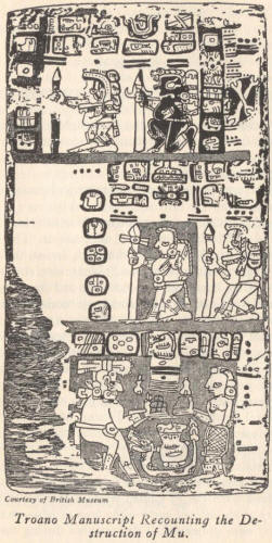
I shall first take the American written records, commencing with the
Troano Manuscript, an ancient Maya book written in Yucatan. It has
been estimated to be from 1500 to 5000 years old. It is, I think,
between 1500 and 3000 years old. I base this on the form of its
writing.
Several extracts from the Troano Manuscript that I here present will
conclusively prove the correctness of my contention regarding Mu:
Extract 1.
"In the year 6 Kan, on the 11 Muluc, in the month of Zac,
there occurred terrific earthquakes which continued until the 13
Chuen without interruption. The country of the hills of earth - the
land of Mu - was sacrificed. Twice upheaved, it disappeared during
the night, having been constantly shaken by the fires of the
underneath.
Being confined, these caused the land to rise and to
sink several times in various places. At last the surface gave way
and the ten countries (or tribes) were torn asunder and scattered.
They sank with their 64,000,000 inhabitants 8060 years before the
writing of this book."
Geologically, the description "the country of the hills of earth" is
absolutely correct and accounts for the quarries that are to be
found on Easter Island.
Extract 2.
"The birthplace of the sacred mysteries. Mu - the Lands
of the West. That land of Kui. The motherland of the gods."
1. Is one of the letters M in the hieratical alphabet of Mu and is
here alphabetical symbol; thus we have Mu.
2. Is one of the letters T in the hieratical alphabet, and often
used as the word "the" in the spoken language.
3. Is the universal geographical symbol for the Lands of the West.
The characters being in block designate the past tense; thus,
"Mu
was the Lands of the West."
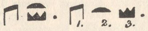
1. That.
2. Land of Kui or Kui Land.
3. Lands of the West.
The Lands of the West were the Land of Kui.
This extract is the most important known passage referring to the
Motherland of Man, for it has already been shown that the
geographical name of the Motherland of Man was the Lands of the
West, and as the Troano Manuscript was written in America, it also
shows that the Lands of the West lay to the west of America. Many
records will be brought forward confirming the fact that the
Motherland of Man lay to the west of America.
"That land of Kui" means the land of departed souls. The Egyptian Ka
with its extended meaning comes out of the Maya Kui.
In ancient times "god" did not mean the Deity. It referred to the
soul of a departed one. Thus, the Motherland of the Gods, mentioned
in the manuscript, means, by extension, the Motherland of Man.
Sir Gardner Wilkinson, the great Egyptologist, in his book, Manners
and Customs, Volume III, page 70, says:
"Kui-Land or the Land of Kui, according to the Maya language, was
the birthplace of the goddess Maya, the mother of the gods - and of
man."
Extract 2, by the way, is corroborated many times in the Egyptian
Book of the Dead.
CODEX CORTESIANUS
The Codex Cortesianus is another of the old
Maya books that escaped the eyes of the fanatical Bishop Landa.
This
book is now in the National Museum of Madrid. The characters,
figures and writings would indicate that it is of about the same age
as the Troano Manuscript. The language of the Codex Cortesianus,
however, is much more symbolical than that of the Troano Manuscript.
Here are some extracts from it, bearing on our subject:
"By his strong arm Homen caused the earth to tremble after sunset
and during the night Mu, the country of the hills of earth, was
submerged."
"Mu, the life of the basin (seas), was submerged by Homen during the
night."
"The place of the dead ruler is now lifeless, it moves no more,
after having twice jumped from its foundations: the king of the
deep, while forcing his way out, has shaken it up and down, has
killed it, has submerged it."
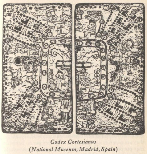
"Twice Mu jumped from her foundations; it was then sacrificed by
fire. It burst while being shaken up and down violently by
earthquakes. By kicking it, the wizard that makes all things move
like a mass of worms, sacrificed it that very night."
It is self-evident that both the Codex Cortesianus and the Troano
Manuscript were written from the same temple record. The Codex
Cortesianus gives the land its hieratical name only, while the
Troano Manuscript gives both its hieratical and geographical names.
THE LHASA RECORD
This record was discovered by Schliemann in the
old Buddhist Temple of Lhasa, Tibet.
Schliemann deciphered and
translated it. It evidently does not come from the same original
record as do the Troano Manuscript and the Codex Cortesianus. It is
more modern and is not written in Maya characters.
Here is an interesting extract from the Lhasa Record:
"When the star of Bal fell on the place where now is only the sky
and the sea, the seven cities with their golden gates and
transparent temples, quivered and shook like the leaves in a storm;
and, behold, a flood of fire and smoke arose from the palaces.
Agonies and cries of the multitude filled the air.
They sought
refuge in their temples and citadels, and the wise Mu - the Hieratic
Ra Mu - arose and said to them: did I not predict all this? And the
women and the men in their precious stones and shining garments
lamented 'Mu, save us!' and Mu replied: 'You shall all die together
with your servants and your riches, and from your ashes new nations
shall arise. If they forget they are superior not because of what
they put on but what they put out the same will befall them.'
Flames
and smoke choked the words of Mu: the land and its inhabitants were
torn to pieces and swallowed up by the depths."
Bal is a Maya word meaning "Lord of the Fields."
"Transparent
temples" is, without doubt, a mistranslation. These temples were not
built of glass or any other transparent substance. They were open or
roofless temples so constructed that the rays of Ra - the sun -
could fall upon the heads of those who were in prayer and
supplication within the temple, like the Parsee temples of today.
Le Plongeon found records in Yucatan stating that,
"the Hieratic head
of the Land of Mu prophesied its destruction, and that some, heeding
the prophecy, left and went to the colonies where they were saved."
Le Plongeon's death occurred many years before Schliemann published
the Lhasa Record.
UXMAL TEMPLE
This temple is situated at Uxmal, Yucatan, and has
been named by Le Plongeon "The Temple of Sacred Mysteries." On its
walls there is an important inscription which reads:
"This edifice
is a commemorative monument dedicated to the memory of Mu - the
Lands of the West - That Land of Kui - the birthplace of our sacred
mysteries."
This temple is built facing west, where the Motherland once stood.
The inscription quoted is a full corroboration of the second extract
from the Troano Manuscript, and confirms other records which state
that the Motherland lay to the west of America. Further - and this
is most important - it tells us that the religious teachings of this
temple came from there. So that whatever we find here we know
originated in Mu, the Lands of the West. With this information, we
can trace the Egyptian religion and learning back to its source.
XOCHICALO PYRAMID, MEXICO
This pyramid is situated 60 miles
southwest of Mexico City, and antedates all of the Egyptian pyramids
by thousands of years.
The picture (between pages 160-1) shows
inscriptions in the form of a pictorial tableau, which is divided
into two sections. The upper - or may I call it the Cornice? -
relates how the destruction of Mu - the Lands of the West occurred,
and what forces were active in her destruction, also the origin of
these forces.
A great part of this section of the tableau has been lost by the
falling of stones, and some of what remain are so weathered and
broken as to be unreadable; therefore, I shall not attempt to give
the exact legend, but rather the import of it only.
The lower or main part of the tableau is in fairly good condition
for reading, although many parts are too weathered to get all of the
details. We can, however, give a general deciphering, but with many
details left out.

Part I - The Cornice
1. An elongated square the hieratic letter M,
alphabetical symbol of Mu - the Motherland. On one side are two
scallops, the two islands which, with Mu, made up the Lands of the
West.
2. Volcanic forces working within and underneath Mu tearing her to
pieces.
3. The Maya "Tian Chilians" symbol of the Four Great Primary Forces,
shown as coming direct from the Infinite - His "command," "desire,"
"order," etc.
4. The head or point of an arrow, spear or javelin - the symbol
showing the forces are active. Through the spearhead is a line
dividing it, the symbol showing that it is not one of the Primary
Forces, but a subsidiary, coming out of a primary.
5. This is a compound symbol dividable as follows:
a. Elongated square symbol of Mu.
b. The four pillars supporting her.
c. The forces have caused the pillars to give way, and Mu is being
carried down.
6. A human figure, denoting that human beings went down with the
land.
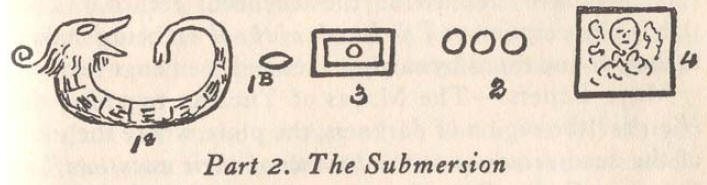
Part 2 - The Submersion
1a. A conventional serpent - symbol of the
great waters. It is coiled in the shape of the hieratic letter U,
symbol of an abyss - an abyss of water.
1b. The eyes of this serpent are closed. Being closed, they
symbolize sleep, rest. The waters are at rest, having found their
own level.
2. The numeral three - Mu's numeral symbol.
3. One of the symbols for the Lands of the West. Being below the
surface cuts 2 and 3 say Mu - the Lands of the West - has been
submerged.
4. The tail of the serpent, the waters, is curved inwards and down
embracing in its coil a human figure; saying that the inhabitants
went down with the land.
There are other details in this tableau, but they are in too poor a
condition to warrant an attempt at reading.
Supplementing the foregoing with other inscriptions on this pyramid,
I will give its legend.
Legend. This pyramid is erected as a monument to Mu, the Motherland
of Man, the Lands of the West, to commemorate her memory and her
destruction with all mankind thereon. The pillars that supported her
were attacked by great forces, they gave way, then Mu and all her
people sank into the watery abyss.
Plato's Timeus says that this Mexican pyramid is an exact model of
the Sacred Hill of Atlantis on which was built the Temple of
Poseidon.
Plato lived 400 B.C. and yet we are being taught that Columbus
discovered America!!
Akab-Dzib
In the city of Chichen Itza, there is a slab which
forms the lintel of the door of the inner chamber at the southern
end of the building called Akab-Dzib. Here we have "the awful, the
tenebrous record."
This slab is a description of The Lands of the
West being shaken to their foundations by earthquakes and then
engulfed.
Maya Beliefs
The Mayas of Yucatan regarded the West as "the
region of darkness, the place where the souls of the dead returned
to the bosoms of their ancestors," as shown in Codex Cortesianus.
Valmiki, "Ramayana"
Vol. I, page 342
"The Maya adepts, the Naacals, starting from the land of their birth in the east, as
missionaries of religion and learning, went first to Burma and there
taught the Nagas. From Burma they went to the Deccan in India,
whence they carried their religion and learning to Babylonia and to
Egypt."
Burma
At Angkor Thorn, Cambodia, may be seen conventional beasts
that archaeologists have called "lions."
All are placed facing the
east, looking toward the place where the Motherland once stood. That
these beasts refer to her there can be no question, as they are
saying "Mu." This is shown by their conventional mouths, elongated
squares, one of the forms of the letter M in the hieratic alphabet
of Mu, and one of her symbols.
Plutarch - Life of Solon
"Souchis, the High Priest of Sais told
Solon [600 B.C.], also Psenophis, a priest of Heliopolis, that 9000
years before, the relations of the Egyptians with the inhabitants of
the Lands of the West had been interrupted because of cataclysms
destroying the intervening country, and - the mud that had made the
sea impassable since the destruction of Atlantis by earthquakes and
submersion."
It is here shown beyond controversy that the Lands of the West were
to the west of America, because America was the "intervening lands"
that prevented travel to them when she was made impassable by
cataclysms.
Again it is clearly established that neither Atlantis nor the
intervening country was the Lands of the West, nor was Atlantis the
intervening land, because the intervening land was made impassable
only, while Atlantis was submerged.
I shall next make a survey of the South Sea Islands and note the
stone remains found on them, also the extraordinary and astounding
legends found among the savages and semi-savages there.
In going out on the Pacific Ocean from America we shall be traveling
west - from America. The reader will kindly note, that out on the
Pacific Ocean we are west - of Yucatan; remembering this, it will
enable him to appreciate certain records that hereafter appear.
Among the specks of land forming the Polynesian and other groups, we
shall find links that joined, in prehistoric times, the civilization
of America with the civilizations of Southern and Eastern Asia, and,
eventually, the various civilizations throughout the world. Although
the journey is long, it will be interesting and full of astounding
surprises.
Where we shall look for the remains of an ancient
civilization, and where we shall find it, will be on islands that
within the memory of living man were inhabited by cannibalistic
savages, many of which are cannibalistic to this day.
Yet these cannibals, as I have shown, are the descendants of highly
civilized peoples. The forefathers of the present Polynesians, now
savages and semi-savages, were once the center of the earth's
civilization.
Valmiki, Ramayana
Vol. I, page 353
"The Mayas were mighty
navigators, whose ships traveled from the Western to the Eastern
oceans, and from the Southern to the Northern seas in ages so remote
the sun had not yet risen above the horizon.
"That likewise, being learned architects, they built great cities
and palaces."
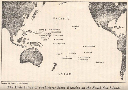
The Great Stone Remains of the Pacific Islands
Throughout the
length and breadth of the Pacific Ocean are scattered groups of
small islands.
On scores of them are the remains of a great
civilization. There are great stone temples, cyclopean stone walls,
stone-lined canals, stone-paved roads and immense monoliths and
statuary - works that required continental resources and workmen of
skill. Yet we now find them not on a great continent, but on mere
specks of land inhabited by savages and semi-savages.
These great ruins appeal alike to layman and scientist as being the
work of a great past civilization that existed ages ago, about which
we know nothing.
These remains are so many, so scattered, that in attempting to
enumerate and describe them it is hard to tell where to begin or how
to end. It would require volumes instead of a few pages to describe
them all. I can, therefore, give only a mere glance at what deserves
a long and detailed study. The description will be popular, not
technical.
On many of the islands the remains are so overrun with vegetation
and covered up with soil that it is difficult to find them. I do not
believe that one-half are visible; they are simply overgrown mounds.
Another difficulty with which the explorer has to contend is the
savage inhabitants; they all have a superstitious dread of going
near any of the great ruins. They believe them to be haunted by
ghosts and evil spirits, which they call mauli, so that it is next
to impossible to get any of them to guide you to the ruins or even
to tell where they are. A good way to discover their whereabouts,
however, is to have a native show you over the island; but, go your
own way and do not follow him.
Simply take him along to tell you the
best road home. If you are approaching a ruin he will try to make
you go in an opposite direction. Should you persist in going on,
when you get near the ruin he will run away and leave you. Then you
will know you are close to the object of your search.
I shall make my start with the remains on
Easter Island. They are
better known than any of the others.
EASTER ISLAND
Easter Island is situated at the southeastern
extremity of Polynesia, 2100 miles from the coast of South America.
Its greatest length is 13 miles and its greatest width 7 miles.
On this little island there are at present, all told, 555 carved
stones, colossal statues, as well as other examples of the art of a
great prehistoric race.
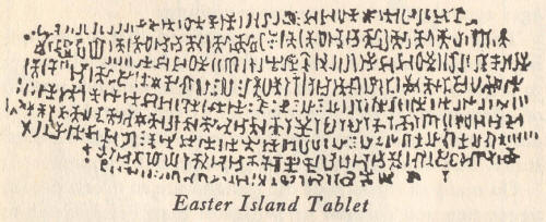
W. J. Thomson, whom I believe to be the best authority on what is
found on Easter Island, says:
"The largest image is in one of the quarries in an unfinished
condition and measures 70 feet in height; the smallest was one found
in a cave, and was about 3 feet long. The majority of them are from
15 to 18 feet high. It is supposed these images represent
distinguished personages, and are intended as monuments to their
memory."
The tops of some of these towering stones are capped with huge
spheres, which show red in the distance.
Many of them were carved
from the red igneous rock forming the sides of the now silent
volcanoes. One of these spheres, which is carved out of a red
sandstone, measures 12 feet in diameter. It is to be seen at the
quarry at Terrai Hills. Besides the statuary on Easter Island there
are several immense platform-like accumulations of cut and dressed
stone.
These piles are about 30 feet high and from 200 to 300 feet in
length. They are awaiting shipment to some other part of the
continent for the building of temples and palaces.
Near the extinct volcanoes Rana Roraka and Rana Rao are the remains
of what was once a large stone temple. As the fallen stones lie,
they outline a structure of about 100 feet long and 20 feet wide.
Walls are still standing 5 feet high and 5 feet thick. Some of the
stones of this structure have carved upon them figures which were
the sacred symbols used in the first religion of man.
W. J. Thomson:
"There are in existence about 7 tablets, all that are
left of a vast number, bearing the written story of Easter Island."
Thomson, with the aid of an old native, the only one on the island
who knew the meaning of the glyphs on these tablets, deciphered and
translated some of them.
Herewith is Thomson's translation of two:
Tablet I.
"When this island was first created and became known to
our forefathers, the land was crossed with roads beautifully paved
with flat stones. These stones were laid together so nicely that no
rough edges were exposed. Coffee [mistranslation] trees were growing
close together along the borders of the roads. They met overhead and
their branches were laced together like muscles.
"Heke was the builder of the roads, and it was he who sat in the
place of honor, where the roads branched away in every direction.
"In that happy land, that beautiful land where Romaha formerly lived
with his beloved Hangarva.
"Turaki used to listen to the voices of the birds and feed them.
"In that beautiful land governed the gods from Heaven, who lived in
the waters when it was cold.
"There the black and white pointed spider would have mounted to
Heaven, but he was held back by the bitterness of the cold."
Remains of these roads are to be seen on Easter and many other of
the South Sea Islands.
Tablet 2, entitled "The Great King":
"What power has the Great King
on land? He has the power to make the plants grow and to change the
color of the sky.
"All hail the power of The Great King who makes us lenient to the
young plants, to admire the different colors of the sky and to
behold the clouds that rise.
"All hail the power of The Great King who enables us to appreciate
the blessings of bright stars, the lowering clouds, the gentle dew,
the falling rain and the light of the sun and the moon.
"What power has The Great King on land?
"He has the power to populate the earth to create both kings and
subjects.
"All hail to the power of The Great King, who hath created the human
beings, given authority to kings, and created loyal subjects.
"What power has The Great King?
"He has the power to create the lobsters, white bait, eels, ape-fish
and everything in the sea.
"What power has The Great King over the seas?
"He hath the power to create the mighty fish that swim in deep
water.
"All hail the power of The Great King who enables us to withstand
the attacks of the maggots, flies, worms, fleas and all manner of
insects."
A legend tell the following:
"This little island had once been a part of a great continent of
land, crossed with many roads, beautifully paved with flat stones.
The roads were cunningly constructed to represent the plan of the
web of the gray and black pointed spider, and no man could discover
the beginning or the end thereof."
W. J. Thomson:
"At the south end of the island there are from 80 to
100 stone houses, built in a regular line against a terrace of rock
or earth, which in some cases form the back walls of the building.
The walls of these peculiar houses average 5 feet in thickness and
4½ feet in height. They are 4½ feet broad and 13 feet long.
"The doorways are tiny affairs, not more than 20 inches high and 19
inches wide. The walls are formed by layers of irregular stones.
These latter are often painted red, white and black, showing birds,
faces and figures.
"Near the houses the rocks on the banks of the sea-cliff are carved
in strange shapes, resembling human faces, tortoises, birds, fishes
and mythical animals."
The history of Easter Island since the white man discovered it forms
one long scene of tragedies.
COOK GROUP
The Cook group of islands lies directly south of
Hawaii about 40 degrees. It is also about halfway between Tahiti and
Fiji, but south of a direct line. I shall note two islands of this
group.
RARATONGA ISLAND
On this island there is a small section of the
road referred to in the Easter Island tablet and legend.
MANGAIA ISLAND
This is the southernmost island of the Cook group
and about half the size of Easter Island.
On it are remains similar
to those on Easter Island. As there are no quarries, or evidences of
their being chiseled on this island, it is presumable that they were
brought here.
TONGA-TABU
Tonga-tabu is a coral atoll belonging to the Tonga
group.
There is not a particle of natural stone upon it, nothing but
corals. Here on this patch of coral we find an immense stone
monument, set up in the form of an arch. It consists of two huge
uprights weighing about 70 tons each, which are bound together at
the top with another stone weighing about 25 tons.
There being no native stone on the island and the nearest available
stone being over 200 miles away, it leaves open a wide field for
speculation as to what sort of ships the ancients had to carry such
enormous weights, how they landed them from the ships, and what
contrivances they had to set them up in place, as we now find them,
after they had been safely landed.
THE GILBERT AND MARSHALL GROUPS
On several of the islands
composing these two groups are found tall, slender pyramids built of
stone.
The natives use the sacred symbols of the Motherland as
ornamentations without knowing how they obtained the designs, or
their meanings. I have shown a prominent ornamentation from Arorai
Island - the fan of Princess Arawali with the royal escutcheon of
Mu.
THE CAROLINE GROUP
As regards prehistoric remains, nowhere
throughout the Pacific Ocean are there to be found such astounding
ruins as on the Caroline Islands.
An added interest is that they lie
"one moon's journey towards the rising sun (from Burma)," where
according to the Naacal tablets and Valmiki, the Motherland of Man
once stood, the spot whence came the first settlers in Burma and
India.
PANAPE
On Panape stands what I consider to be the most important
ruin in the South Sea Islands. It consists of the ruins of a great
temple, a structure 300 feet long by 60 feet wide, with walls still
standing (in 1874) 30 feet high, and at the ground 5 feet in
thickness.
On the walls are the remains of carvings of many of the sacred
symbols of the Motherland.
This temple is connected with canals and earthworks, and has vaults,
passages and platforms. The whole is built of basaltic stone.
Below the pavements of the great quadrangle, on opposite sides, are
two passages or gateways, each about 10 feet square. These are
pierced through the outer wall with passageways leading down to the
canal. Within the great quadrangle is a central pyramidal chamber,
unquestionably the holy of holies.
According to the natives, many generations ago this temple was
occupied for a time by the shipwrecked crew of a Spanish buccaneer.
Relics of these outlaws are still being found in one of the vaults
which they used as a storehouse.
The natives cannot be induced to go near the ruin, because they say
it is haunted by ghosts and evil spirits, which they call mauli.
Other ruins also are on Panape, some of them close to the seashore,
others on tops of mounds or hills, or are to be found on cleared
spaces towards the center of the island, but all command views of
the ocean. On one of the cleared spaces there is a ruinous heap of
stones covering between 5 and 6 acres; it is situated on a sort of
tableland. Around it there appears to have been a ditch or a canal.
At the corners, which were at the cardinal points, the ruins assume
tall mounds, indicating by their various distribution that the
building was square.
To my mind the various ruins on Panape are ruins of one of the
Motherland's capital cities, one of the Seven Sacred Cities. It is
impossible to estimate the population, but it must have been very
large - a hundred thousand at least.
SWALLOW ISLAND - 12° east of Panape
On this small island is a
pyramid of similar construction to that found on Guam and Tinian.
On the west side of the island is a vast quadrangular enclosure of
stone, containing several mounds. Probably if the coverings of guano
and soil were removed edifices of some kind would be found.
KUSAI ISLAND, southeast corner of the group
On this and the
surrounding islands are found similar ruins to Panape, but not
nearly so extensive.
On the south side of the harbor of this latter island are several
canals lined with stone. They cross each other at right angles.
Between their intersections are artificially made islands, which
originally had buildings on them. One tower still remaining is about
35 feet high.
Native traditions of this island say:
"The people who once lived
here were very powerful. They had large vessels in which they made
voyages far distant, east and west, taking many moons to complete a
voyage."
Does this not entirely agree with Valmiki when he says,
"The Mayas were mighty navigators, whose ships passed from the
eastern to the western oceans and from the southern to the northern
seas"?
LELE ISLAND is separated from Kusai Island by a narrow channel. On
this island is a conical hill surrounded by a wall 18 or 20 feet
high and of enormous thickness.
The whole of this island presents a
series of cyclopean enclosures and lines of great walls. Some of the
enclosures are parallelograms 200 by 100 feet in extent. There is a
very large one between 300 and 400 feet in length and over 150 feet
wide.
The walls generally are 12 feet thick, and within are vaults,
artificial caverns and secret passageways.
The natives of this corner of the Carolines were extremely hostile
to the white man and were cannibals of the worst description in
1874. Possibly they have been tamed down a bit since then.
KINGSMILL ISLANDS
On Tapiteau Island of this group are found the
same tall, slender pyramids of stone as are found in the Gilbert and
Marshall groups.
NAVIGATOR ISLANDS
On these islands are found great stone
structures. On one of them there is a remarkable structure on the
top of a 1500-foot hill, and near the edge of a precipice which has
a sheer drop of 500 feet. The structure is a platform built of huge
blocks of igneous stone. It is 150 feet in diameter and 20 feet
high. On one side of this structure is the precipice and on the
other a ditch, which originally might have been 18 or 20 feet deep.
LADRONE, OR MARIANA GROUP (Guam)
The relics on these islands have
a character of their own.
They consist principally of solid stone,
truncated pyramidal columns, usually about 20 feet high, including
the hemispherical stone or capital, and ten feet square at their
bases. Some are capped with a stone hemispherical in shape, in other
cases these stones lie on the ground as if they had been shaken off
by seismic disturbance. On the island of Tinian they are arranged in
columns.
Extract from article by Larrin Tarr Gill:
"Three of the latter have
fallen with their tasa still intact; three are completely shattered
and the capitals of two lie as though shaken from their supports by
some violent shudder of the earth. Shaped like truncated pyramids
and capped by hemispherical stones, the pillars are 18 feet in
circumference at the base, 11 feet high, and taper at the top to a
little over 15 feet around, on which the capitals stand 5 feet high
and 6 feet thick. Hewn from rough, hard, sedimentary rock, each
monument weighs close to 30 tons and the two parallel lines of
columns, which originally stood 7 feet apart formed a ground plan
almost 54 feet long by 10½ wide."
HAWAII
"About 30 miles from Hilo there is a great ruin on a hill
called Kukii. There are no stones on this hill except those which
have been carried there.
"The summit was leveled and squared, and the building laid out
according to the cardinal points and the floor paved. Two square
blocks of stone in an upright position, about 15 or 16 feet apart,
range exactly east and west.
"The upper part of the hill was terraced, and the terraces had been
faced with hewn stone. The stones were perfect squares, the smallest
three feet in diameter, while others were larger. Every stone was
faced and polished on all sides, so that they could perfectly fit
together. There is still about 30 feet of facing left on the lower
terrace partly in position.
"On the western side there was a stairway running from the base to
the top of the hill, a height of nearly 300 feet.
"On Kona is another ruin."
THE MARQUESAS
There are several noteworthy ruins on the Marquesan
Islands. Apparently no one has ever felt inclined to make an
examination of them. I believe the fact that they are there has
never before been published.
The foregoing is a long list of Titanic stone remains, and yet I
have not enumerated one-half of what are to be found on the South
Sea Islands. From this evidence the logical mind can form only one
conclusion, and that is: At one time in the earth's history there
was a great continent of land in the Pacific Ocean which embraced
all of the groups of islands where prehistoric remains are to be
found. This great continent had an exceedingly high civilization.
That continent was Mu, the Motherland of Man. That her name was Mu
and her geographical position are attested by the records of India,
Uighur, Egypt, Mayax, Peru and of the cliff dwellers of North
America.
These cyclopean remains are her pathetic withered fingers that
refused to go down with her broken back and mangled body.
NEW ZEALAND
The Maoris, natives of New Zealand, are rich in
legends and traditions of the dim past.
Many of the ancient sacred symbols are also found among them. The
most prominent is the Tat or Totem Pillar, which they erect at the
entrance of their villages. In employing the name Tat I am employing
the Egyptian. These pillars were used by the Mayas, Incas,
Atlantians, Egyptians, Chaldeans, and other ancient peoples.
The
meaning of the Tat or Totem Pillar is given in my section on the
ancient Sacred Symbols
AUSTRALIA
Australia appears to be particularly bare of ancient
records, legends and traditions, and this is not to be wondered at
if my geological deductions about Australia are correct.
Geometrical figures have been found rudely carved on some of the
boomerangs of the Northern tribes. The bush-men of Northern
Australia are probably the lowest type of humanity on earth, lower
than the ordinary forest beasts.
An Australian cave painting has been found which, without doubt,
antedates their low savagery.
There are three remarkable objects in the painting: the first is Ra
- the Sun - and the second the numeral 3, symbol of Mu, shown twice,
and the third an axe.
When the English first settled in Australia, axes of any description
were unknown to the savage natives.
I have never heard of any legends or traditions having been found
among the native Australians.
After deciphering and translating the symbols found carved on the
stones of the ancient Polynesian remains of the temples and
statuary, and in the quarries among the unfinished work, I felt at
the time that among the South Sea Islands, and especially in the
division called Polynesia, traditions might be found that would
prove of the greatest value in connecting the past civilization of
the South Sea Islands with a civilization of a later date, of which
we have at least some fragmentary records.
The great stone monuments existing among the South Sea Islands have
always been a puzzle to ethnologists. All have been convinced that
there must have been a great civilization there, and then,
"the
shadow of time that was, became darkness; the new day, the
beginning, as civilization now calls it, dawned thereafter."
Assumptions have been made that the white Polynesians came down from
the original white race and it seems to be supported by records and
traditions found in various parts of the earth: Mexico, Central
America, India and Egypt.
In Central America and Mexico there are traditions stating that the
first people who inhabited those countries were a white race.1
1 See Guatemalan tradition quoted on page 173.
The
Mayas of Mayax, those who built the great edifices whose ruins now
dot the land, were a white race. Temple inscriptions in Yucatan say
they came there from lands that lay to the west of America.
Polynesia lies to the west of America.
The Guatemalan tradition also shows the white race advancing to the
east from America.
Hindu records tell us that the central parts of India (the Deccan)
were first colonized by a white race called Mayas, who came to India
via Burma, and that their motherland was one moon's journey towards
the rising sun, east of Burma. Polynesia lies to the east of Burma.
It is thus shown that those coming to America came from the west,
and those coming to India came from the east. This is conclusive
evidence that the original home of the white race was a land that
lay geographically between America and Asia.
Among these people I find a tradition of the Creation, corresponding
in all material details with that of the ancients throughout the
world:
Ellis, "Polynesian Researches," Vol. I, page 100:
"In the Sandwich
Islands (Hawaii) there is a tradition that in the beginning there
was nothing but water, when a big bird descended from on high and
laid an egg in the sea; the egg burst and Hawaii came forth."
This is the cosmogony of all the ancients. All say water covered the
face of the earth, and that life started from a cosmic egg laid in
the sea.
SAMOA
The Samoans have a tradition that "In the beginning the whole
earth was covered with water."
The Flood. - O'Brien says in Mystic Isles of the South Seas:
"In most of Polynesia there are legends of a universal flood from
which but few escaped."
Adam and Eve. - "The Polynesians had very fixed ideas upon the
origin of the universe and man."
HAWAII
"Taaroa made man out of red earth Araea and breathed into
his nostrils. He made woman from man's bones and called her Ivi."
(In the Polynesian language Ivi is pronounced Eve-y.)
Cain and Abel. - A Tonga tradition states that "the son of the first
man killed his brother."
NEW ZEALAND
A tradition of the Maoris states,
"that the son of the
first man killed his brother."
Tower of Babel. - "In Fiji is still shown the site where a vast
tower was built because the Fijians were curious and wanted to peep
into the moon to discover if it was inhabited."
Polynesian Cosmogony. - Tahiti: "Taaroa, whose name was spelt
differently in separate archipelagos, was the father of Tahiti an
cosmogony. His wife was Hina - the earth, and his son Oro was the
ruler of the world. Tane the Hualine god was a brother of Oro and
his equal."
This corresponds with the cosmogony of the most ancient, namely, a
Trinity or a Triune Godhead.
MYSTIC FORCES
During the time of the earth's first civilization,
many abstruse sciences were known which today are not known. They
have been lost between the two civilizations.
The adepts of the ancients could walk through fire without being
scorched, as related in
the Bible and
Popol Vuh.
There is reliable testimony that South Pacific Islanders have been
known to walk barefooted on red-hot stones, without being burnt. The
same thing has been witnessed in Hawaii and I have personally seen
it done in the Fiji Islands.
A few years since a report was made that in Samoa the blind were
made to see through their flesh. The report was sneered at by
scientists, and the public generally looked upon it as a newspaper
story, a traveler's lie.
The following from the New York World, reporting from Paris the
accomplishment of the same phenomenon, answers, I think, the
scientific sneers that were handed out when the report came from the
savages of Samoa.
This article is as follows :
"Not only have you eyes in the back of your head, but your body is
simply covered with them, and they can all be used if trained
properly.
"This conclusion is reached by several scientists here who have
witnessed experiments by Jules Remain, writer of a book on the
subject. They contend, with M. Romain, that just beneath the skin
are 'ocelles' - microscopic organs united to the central nervous
system - and that these are dormant eyes.
"M. Romain, it is claimed, has succeeded in training a number of
persons to use these eyes effectively. They can distinguish colors
and read while heavily blindfolded. Some can see with cheeks and
fingers, some with their noses. One subject was able to distinguish
a hat four yards away.
"These results, it is asserted, are accomplished after the subject
has been placed in a state of great mental concentration not allied
to hypnotism.
"While the first experiment is not apt to show much result, second
tests have shown in some subjects an ability to 'read' playing cards
blindfolded after three hours of concentration. The ability of the
subject, it is said, improves with each succeeding test."
Thus it is now demonstrated that the blind can be made to see
through the skin, but the Samoan practiced it thousands of years
ago.
The foregoing traditions and legends are astounding, and at first
glance must stagger one, for here among savages who have been shut
off from the outside world up to within 300 years and most of them
within 200 years, we are met with the fact that they have among
themselves legends and traditions about the Creation and the early
history of man that are identical with the legends and traditions
found in the Bible.
GREECE
A few references to the Motherland of Man are to be found
among the writings of the old Greek philosophers.
In the year 403 B. C., during the archonship of Euclid, the Greek
grammarians rearranged the Athenian alphabet in its present form.
The Greek alphabet today is composed of Maya vocables forming an
epic that relates the destruction of Mu. The translation of the
Greek alphabet is as follows:
THE GREEK ALPHABET
The alphabet of the Greeks is an epic composed of Cara-Maya
vocals, and is a commemorative memorial to their forefathers who
lost their lives at the destruction of Mu.
In Plato's Timeus and Critias we find this reference to the lost
continent:
"The Land of Mu had ten peoples."
Proclus wrote:
"The Lands of the West had ten peoples."
Here we find two of the old Greek philosophers writing about the
Motherland of Man. One uses its hieratical name, the other its
geographical name, but both assert that there were ten separate
peoples.
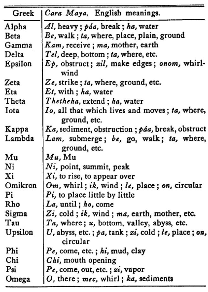
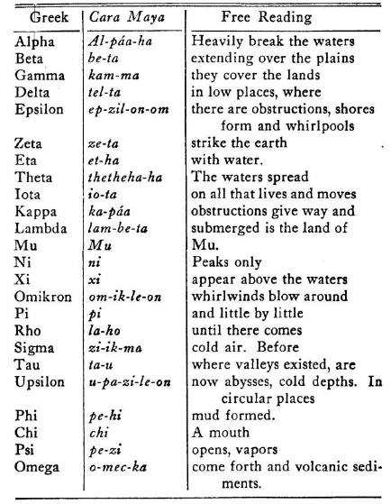
Straight Reading. - Heavily break the waters over the plains. They
cover the low places. Where there are obstructions shores form. The
earth is struck with water ; the waters spread on all that lives and
moves, the foundations give way and submerged is the land of Mu. The
peaks only appear above the water, whirlwinds blow around until
gradually comes cold air. Before where existed valleys are great
depths, cold tanks. In circular places mud banks formed.
A mouth
opens, out of which vapors pour forth and volcanic sediments.
The Greek Alphabet written in the Hieratic Characters of Mu
This is written to read from left to right. The ancients generally
wrote to read from right to left, when the writing was in horizontal
lines.
Origin of the Greek Cross
The Greek Cross as it is known has
always been an enigma and a puzzle to scientists on account of its
being found in so many inscriptions which are unreadable to our achaeologists. It appears in inscriptions in Yucatan and Central
America especially.
Winter, in his work "Guatemala," page 156, says:
"The mysterious
symbol of the Greek cross, which has also been found on the stones
of Quirigua and Copan, has been the cause of much speculation among
scholars."
No one, apparently, can solve this simple problem.

The Greek Cross, Fig. I, was the central figure of the Royal
Escutcheon of Mu - the Empire of the Sun.
The hieroglyph is a phrase
in the mother tongue of Mu, reading U-luumil (pronounced
Oo-loo'-oom'-il).
Translated into English it is:
"the land of, the
country of," and by extension, "the Empire of" or "the Kingdom of."
So that in all of the inscriptions where it appears, it represents
one of the foregoing phrases, depending on what comes before and
what comes after it.
The Greek cross confirms the accuracy of my deciphering of the Greek
alphabet; the Greek alphabet confirms the accuracy of my deciphering
of the cross; and the two confirm the existence of Mu - the Empire
of the Sun - and that she was the Motherland of the Greeks.
Back to Contents
|


