Quantitative Modeling
Quantitative Modeling
it is difficult to believe that chance alone can explain this
fitting together of the continental margins, (Barnett, 1962)
To test Global Expansion Tectonics and, in particular, the mathematical
parameters developed from empirical sea floor magnetic isochron data, spherical
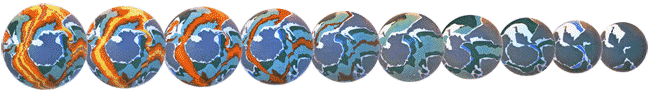
small Earth models for chron intervals corresponding to chron C0 (Present),
C3A (Pliocene), C6B (Miocene), C15 (Oligocene), C25 (Eocene), C29 (Palaeocene),
C34 (Late Cretaceous), M0 (Mid Cretaceous), M17 (Early Cretaceous), M29
(Late Jurassic) and M38 (Mid to Early Jurassic) were constructed using
the "Bedrock Geology of the World" map by CGMW & UNESCO (1990). Models
for the Precambrian are currently in draft format and won't be addressed
at this stage.
For each Post Jurassic model it was assumed that the Earth's lithospheric
budget has been cumulative with time and the surface area of oceanic lithosphere,
as represented by oceanic magnetic isochron data of Larson et al
(1985) and CGMW & UNESCO (1990), is fully fixed in the rock record.
It is acknowledged that if these basic assumptions are wrong then small
Earth modeling may fail, hence consideration should then be given to the
remaining lithospheric budget options previously discussed.
Back to Contents
Methodology
Small Earth models were constructed using high density polystyrene foam
spheres, cut to millimetre tolerance using a computer controlled "hot-wire"
technique, assembled from segments using an equatorial ring jig at the
required radius. These models, shown in the accompanying figures, are
now on permanent display in the Geological Museum of the Polish Geological
Institute, Warsaw.
Plate reconstructions for successively older small Earth models were
manually drafted by subtracting the next youngest isochron interval from
the previous model, with tracings cross referenced to the primary chron
C0 base map and model (after CGMW & UNESCO, 1990) to minimise cartographic
discrepancies. For each model, as older oceanic crust was progressively
eliminated, plate boundaries were then reassembled along their common spreading
axes at a reduced palaeoradius. Due consideration was also given to the
oceanic basin tectonic fabric and bathymetry of Gahagan et al (1988),
and geographical grids were established for each model by adopting the
Cenozoic and Mesozoic north palaeomagnetic pole positions of Andrews (1985).
The south pole and palaeoequator were then scaled through 180° and
90° of latitude respectively, and meridians of longitude established
by adopting Greenwich as 0° longitude in each case.
Published plate tectonic reconstructions of selected areas is extensive
and consideration was given to these during reconstruction where necessary,
as well as the plate tectonic reconstructions of Scotese et al (1988),
and partial expanding Earth reconstructions of Owen (1976).
Reconstruction of continents along continental margins became increasingly
necessary within the Jurassic to Early Cretaceous models. Considering the
potential for sedimentary masking of Jurassic oceanic lithosphere, reconstruction
along these margins varied from: adoption of outer continental shelf margins,
such as Australia to Antarctica to; progressive elimination of ocean basin
sedimentation, such as the Arctic Ocean and Mediterranean Sea; progressive
elimination of younger island arc volcanism, such as Southeast Asia; or
reassemblage of fragmented Palaeozoic to Archaean crust, such as the Canadian
and Greenland Arctic islands.
With the older, smaller radii models, manipulation of continental areas
also became necessary, such as minor rotation of the shield areas of West
Africa relative to East Africa (eg. Sundvik & Larson, 1988; Unternehr
et
al, 1988), or progressive elimination of Tertiary intracontinental
sedimentary basins, such as the West Siberian Basin in northern Russia
(Carey, 1976), in order to accommodate for the changing surface curvature
of successively smaller models.
These modifications to the continental
and oceanic lithosphere were deemed both necessary and fundamental to small
Earth reconstructions, considering the changing spherical geometry involved.
In each case consideration was also given to the continental stratigraphy
and structural history before deciding on the correct modification to be
adopted.
In contrast, for reconstructions using conventional plate tectonics
on a static sized Earth, attention is drawn to reconstructions by Briden
et
al (1981); Weijermars (1986, 1989), Scotese et al (1988), Dalziel
(1991), Hoffman (1991) and Moores (1991), and for reconstructions incorporating
limited subduction, Owen (1976), and Earth expansion, Kolchanov (1971)
and Vogel (1983).
Back to Contents
Development of oceanic regions
A brief descriptive outline of oceanic lithospheric development, and
accompanying dispersal of continents, will now be given for each of the
major oceans and seaways. The text is accompanied by figures representing
the sequential small Earth spreading history for each oceanic basin, from
the Early Jurassic Pangaean small Earth configuration to the Present.An
animation of this process may be viewed at
David
Ford's animation site.
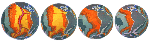
Plate Tectonic Reconstruction
For comparison with the current plate tectonic tectonic model, a chron
M17 (Early Cretaceous) constant Earth radius reconstruction is shown below
(Figure 23), reproduced in spherical format from modeling by Scotese
et
al (1988) who also used oceanic magnetic isochron data. The light blue
in each of these reconstructions represents remnant Jurassic oceanic crust
remaining after subduction, and the dark blue represents supposed subducted,
pre-existing oceanic crust.
In order to maintain a static Earth radius
all of the dark blue areas must be removed and replaced by Post-Jurassic
oceanic crust to the present (see Figure 16).
|
|
|
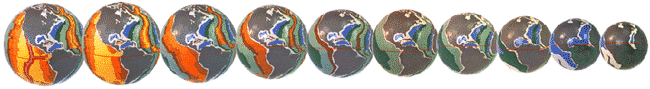
(a) Arctic Ocean (b) South Pacific Ocean (c) Atlantic Ocean (d) Caribbean
Sea (e) Indian Ocean (f) Tethys Ocean (g) South East Asia (h)
Panthalassa Ocean Figure 23 Early Cretaceous Plate Tectonic reconstructions.
(Reconstructions after Scotese et al, 1988)
|
Back to Contents
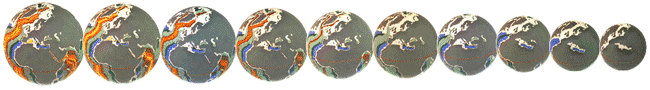
 Arctic Ocean
The Arctic Ocean consists essentially of two large basins; the Amerasia
and Eurasia Basins, separated by the Lomonosov ridge (Figure 24,
chron C0).
Detailed magnetic isochron data for the Eurasian Basin (CGMW
& UNESCO, 1990) show that the bulk of oceanic lithosphere was generated
during the Cenozoic to the Present from the active Nansen-Gakkel spreading
ridge. This spreading ridge forms a continuation of the mid-Atlantic ridge,
offset by the Spitzbergen fracture zone.
Figure 24
Arctic Ocean small Earth sequential spreading
history, from Early Jurassic to the Present. (Isochron data after CGMW
& UNESCO).
The development of the Amerasian Basin indicates there are no active
spreading centres today and the Canadian Basin, which forms part of the
Amerasian Basin, may have an older Late Jurassic and Early Cretaceous spreading
history (Owen, 1983a; Rowley & Lottes, 1988). Spreading ceased in the
Amerasian Basin during the Early Tertiary.
In the small Earth sequential spreading history shown in Figure 24
it is considered that continental extension between North America and Eurasia
during the Jurassic (chron M38 to M17), resulted in opening of the proto-Arctic
Ocean. This initiated as a passive margin extensional basin, extending
southeast into the northern extension of the Atlantic Ocean. During this
time the Alaskan and Siberian Peninsulas were joined and opening of the
Arctic Ocean occurred as a result of clockwise rotation of North America
relative to Eurasia.
Initial fragmentation and separation of the Canadian Arctic Islands,
Greenland, and initial opening of Hudson Bay in North America also commenced
during the Jurassic. This occurred as a result of continental crustal fracturing
and extension as a result of progressive changing surface curvature. Along
the Eurasian Arctic Ocean continental margin crustal extension was more
passive, with shallow basinal sedimentation extending throughout the Arctic
and North Atlantic seaways.
The Amerasian and Eurasian Basins opened during the Cretaceous (chron
M17 to C29) and is considered, from small Earth modeling, to have been
intimately associated with an early, rapid opening of the northern Pacific
Ocean. The opening of these basins was accompanied by extension and strike-slip
dislocation along the still united Alaskan and Siberian Peninsulas, plus
ongoing fragmentation and separation of the Canadian Arctic Islands, Greenland
and Hudson Bay.
From the Late Cretaceous (chron C29) to the present the Arctic Ocean
Basin history was dominated by a northward migration of the North Atlantic
mid-oceanic ridge into the Arctic Ocean region, and initiation of rifting
between Greenland and Canada. During this phase it is suggested that sedimentation
shifted from shallow basinal to passive marginal shelf sedimentation, bordering
the deep ocean spreading ridges.
This interval is considered to represent
a continuing phase of oceanic and continental crustal extension which resulted
in: further separation of the Canadian Arctic Islands; opening of Hudson
Bay; rifting between Greenland and Canada; and separation of the Alaskan
and Siberian Peninsulas across the Berring Straight during the Miocene.
Because of the limitations imposed by a constant Earth radius, conventional
reconstructions for the Arctic and North Atlantic Oceans (Bullard et
al, 1965; Pitman & Talwani, 1972; Herron et al, 1974; Le
Pichon et al, 1977; Sclater et al, 1977; Srivastava, 1978,
1985; Srivastava & Tapscott, 1986; and Savostovin et al, 1986;
Scotese et al, 1988 [see Figure 23]), predict strain histories that
are not compatible with the circum-Arctic geology, amounting to an excess
of 790 km across regions where no evidence of shortening exists (Rowley
& Lottes, 1988).
Rowley & Lottes (1988), although still constrained by a constant
Earth radius model, revised the previous plate reconstructions and concluded
that: the evolution of the circum-North Atlantic region was dominated by
the relative motion history of North America, Eurasia and Greenland; that
sea floor spreading between North America and Eurasia began approximately
110 my ago (mid Albian); and the geology of the circum-Arctic shelf is
characterised by extension and strike-slip basins, but lacks any evidence
of mid-Mesozoic or younger structures associated with contractural deformation.
Rowley & Lottes (1988) reconstruction for the Early Cretaceous is
considered comparable with the Early Cretaceous small Earth reconstruction
(chron M17) (Figure 24), with their predicted positioning of the
Alaskan/Siberian Peninsular regions more accountable on an Earth of much
reduced palaeoradius.
Back to Contents
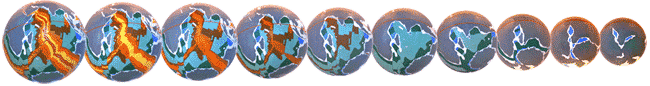
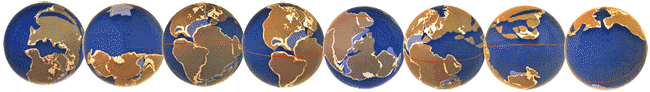
Atlantic Ocean
The closely matching outlines of continents bordering the modern Atlantic
Ocean have been well known since the pioneering
 work of Wegener
(1929). This work formed the basis for the establishment of modern global
tectonic principles. The Atlantic Ocean can be subdivided into north and
south regions, and reference is also made to the Central Atlantic region
adjacent to the Caribbean Sea.
work of Wegener
(1929). This work formed the basis for the establishment of modern global
tectonic principles. The Atlantic Ocean can be subdivided into north and
south regions, and reference is also made to the Central Atlantic region
adjacent to the Caribbean Sea.
The opening of the Atlantic Ocean as a result of Earth expansion is
depicted in the sequential spreading history (Figure 25) and commenced
with a meridional orientated opening in the Central Atlantic region, between
Africa and North America, during the Early Jurassic.
Differential movements
of North America, South America and Africa during the Mesozoic and Cenozoic
resulted in migration of the South Atlantic into the North Atlantic Ocean
region and opening of the Gulf of Mexico and Caribbean regions.
Atlantic
Ocean Animation
Figure 25
Atlantic Ocean small Earth sequential
spreading history, from Early Jurassic to the Present. (Isochron data after
CGMW & UNESCO)
Back to Contents
North Atlantic Ocean
In the sequential small Earth models depicted in Figure 25 the
North Atlantic is considered to have initiated as a passive margin basin,
extending northwards into the Arctic Ocean with time. From an initial meridional
orientated rift basin during the Early Jurassic an anti-clockwise rotation
of the South American/African supercontinent, relative to North America,
resulted in an initial phase of rifting and separation of the two continents,
spreading westwards to form the Caribbean.
During the Early Cretaceous the North Atlantic Ocean spreading ridge
extended northwards between the Grand Banks continental shelf of Canada
and Iberia, in response to progressive widening of the more southerly basin
regions of the Central Atlantic Ocean.
During the Late Cretaceous, spreading limbs extended northwards into
the Arctic Ocean; northwest into the Labrador Sea rift zone between Canada
and Greenland; and northeast, causing rifting and rotation of Spain relative
to France and England.
From the Late Cretaceous the North Atlantic spreading ridge then continued
unabated to the present as a symmetrical spreading axis, in conjunction
with the Nansen-Gakkel spreading ridge within the Arctic Ocean.
Back to Contents
South Atlantic Ocean
In the sequential small Earth models depicted in Figure 25 the
South Atlantic Ocean is considered to have originated as a passive margin
basin, commencing as a rift phase located between the African and South
American coastlines during the Late Jurassic. Basin separation commenced
along the now separated Agulhas and Falklands fracture zones in the south
during the Late Jurassic. This separation progressively extended north,
until breaching into the North Atlantic was completed along the Nigerian/Brazilian
continental margin during the Early Cretaceous. At this time forming a
single Atlantic Ocean.
The subsequent spreading history of the South Atlantic Ocean is one
of progressive symmetrical widening through to the present, with a clockwise
rotation of South America relative to Africa giving rise to a greater spreading
rate in the south.
From the Late Cretaceous onward, the crustal generation in both South
and North Atlantic Oceans occurred along a common mid-Atlantic spreading
ridge, extending to the north and south.
Conventional reconstructions of South America and Africa (Bullard et
al, 1965; Rabinowitz & LaBrecque, 1979; Pindell, 1985; Mascle et
al, 1988; Scotese et al, 1988 [e.g. Figure 23]), on a constant
radius Earth, fit the corresponding margins of North Brazil and Guinea
according to the geological matches. This produces a narrow triangular
void widening southward between the eastern continental margin of South
America and the western margin of Africa south of the Niger Delta region
(Owen 1976).
Conversely, to minimise this southern misfit, the eastern
margin of South America may be fitted against the western margin of Africa,
south of the Niger Delta region. This produces a narrow triangular void
between the Guinea and North Brazilian margins, widening westwards, producing
a significantly greater area of misfit between Florida and Central America.
In order to address these problems of misfit Sundvik & Larson (1988)
and Unternehr et al (1988) resorted to intraplate deformations in
Africa and South America, producing a tighter fit in the South Atlantic.
This however simply shifts the problem of misfit to the Mediterranean and
Caribbean Sea regions.
As shown in the Atlantic sequential small Earth Figure 25, for
an Earth undergoing exponential expansion with time, misfitting between
continental margins in the North and South Atlantic Oceans is eliminated.
During reconstruction however it was found necessary to incorporate the
intraplate deformations addressed by Sundvik & Larson (1988) and Unternehr
et
al (1988), to allow for relief of surface curvature within the African
and South American continents.
Back to Contents
 Caribbean Sea
The development of the Caribbean Sea and Gulf of Mexico basins is shown
in the small Earth sequential spreading history Figure 26.
The region is interpreted to be intimately associated with the plate motion
histories of South America and Africa relative to North America.
While
the two basins shown in Figure 26 are interpreted as originating from a
single Jurassic basin, more detailed reconstruction may show that the two
basins developed separately and were initially separated by a precursor
to the Greater Antilles Arc.
Figure 26 Caribbean Sea small Earth sequential
spreading history, from Early Jurassic to the Present. (Isochron data after
CGMW & UNESCO)
An Early Jurassic phase of intracratonic basin development and associated
sedimentation is inferred, prior to breaching and marine incursion from
the east during the Late Jurassic.
This early basin development is considered
to have been intimately associated with opening and subsequent rifting
of the North Atlantic Ocean, and related to a northwest migration of North
America relative to the South America/ African supercontinent. During this
early extensional phase, lasting until breakup and separation of South
America and Africa during the Early Cretaceous, the Nicaraguan-Panama Peninsula
was joined to South America and underwent extension and strike-slip dislocation.
Following the Early Cretaceous separation of South America and Africa,
South America then underwent a slow clockwise rotation, relative to North
America, in response to spreading in the South Atlantic Ocean. This resulted
in extension and elongation of the Caribbean and Gulf of Mexico basins,
with Paleocene oceanic lithosphere emplaced in the Lesser Antilles and
north Caribbean Sea regions.
From the Paleocene to the Present, South America continued its slow
clockwise rotation relative to North America. This resulted in sinistral
strike-slip motion along the Greater Antilles Arc, extending to the western
margin of Mexico and Gulf of California. Differential rotation between
the North and South American continents resulted in buckling of the Panama
Isthmus and south to north compression of the Columbian Basin. This was
complemented by tensional structures along the southern margin of the Venezuelan
Basin of the southern Caribbean, and northward differential movements of
the Nicaragua-Honduras craton against Yucatan.
Conventional reconstructions of the Caribbean Sea (Pindell & Dewey,
1982; Pindell, 1985; Pindell & Barrett, 1987; Pindell et al,
1988; Ross & Scotese, 1988; Scotese et al, 1988 [e.g. Figure
23]) generally fit the Brazil and Guinean coastlines to minimise the Central
Atlantic misfit. Pindell et al (1988) summarized the Central American basin
evolution as resulting from a divergence of North and South America to
approximately their present relative positions from the Late Triassic?
to Late Cretaceous.
They suggested that, from the Late Cretaceous to the
present, the relative motions between the north and south American plates
had only minor effects on the structural development of the Caribbean region.
During the Late Cretaceous to Mid-Eocene only minor relative motion occurred,
with South America diverging approximately 200 km. Since the Mid-Eocene
the region then underwent minor north-south convergence.
Ross & Scotese (1988) describe the Caribbean region as a "buffer
zone" between the North American plate, the South American plate and subducting
oceanic plates in the Pacific Ocean. This supported Pindell & Barnett's
(1987) suggestion that the Caribbean plate is a preserved piece of the
Pacific Ocean, Farallon plate, and considered it to be allochthonous with
respect to North and South America. Pindell & Barnett (1987) supported
their argument by referring to the origin and timing of formation of the
Gulf of Mexico Santa Cruz Ophiolite, and progressive emplacement of arc
material onto the continental margin of northern South America.
As shown in the Caribbean small Earth sequential spreading history Figure
26 an allochthonous origin for the Caribbean region is considered unnecessary
on an expanding Earth model. The timing and formation of the Gulf of Mexico
and Caribbean Sea agree with the conclusions of Pindell et al (1988) and
Tanner (1983), and emplacement of Santa Cruz Ophiolite and continental
arc material are considered to be a reflection of the ongoing stress règime
between the two continents.
Back to Contents
Mediterranean Sea
 The evolution of the Mediterranean to Middle East region, including
the Black Sea, Caspian Sea and Aral Sea, is shown in the small Earth sequential
spreading history Figure 27.
The evolution of the Mediterranean to Middle East region, including
the Black Sea, Caspian Sea and Aral Sea, is shown in the small Earth sequential
spreading history Figure 27.
The spreading history of this region
is depicted as commencing with an Early Jurassic extensional phase, progressing
towards an intracratonic basin phase, with oceanic lithosphere first developing
during the Late Jurassic. The opening of the Mediterranean to Middle East
region is interpreted to have resulted from a dextral rotation of Europe,
relative to Africa, in conjunction with opening of the Arctic and Atlantic
Oceans.
The opening of the Caspean Sea during the Early Cretaceous, Black
Sea during the Mid-Late Cretaceous and Aral Sea during the Mid-Paleocene
are interpreted to be regions of continental dilation resulting from interaction
between the Arabian Plate and Central Europe.
Figure 27
Mediterranean Sea small Earth sequential
spreading history, from Early Jurassic to the Present. (Isochron data after
CGMW & UNESCO)
From the Mid-Cretaceous to the Miocene the Mediterranean to Middle East
region remained essentially dormant, with relief of curvature during Earth
expansion being taken up by an extension of the Eastern Europe Iberian
Peninsula region, in a northeast-southwest direction.
This phase was marked
internally by an opening of the Adriatic Sea and Alpine mountain building,
and externally by an opening of the Bay of Biscay, between Spain and France,
during the Late Cretaceous. Similarly, opening of the Persian Gulf and
Red Sea commenced during the Eocene, extending to the present. Renewed
oceanic activity in the western Mediterranean region during the Miocene
resulted in outpouring of oceanic lithosphere and continental separation
between West Africa and Spain.
Conventional reconstruction of the Mediterranean to Middle East region
is depicted in Gealey (1988), and the Greek microplates in Turnell (1988).
The models presented depict the region as evolving from a number of microplates,
drifting between Africa and Eurasia during the Mesozoic closure of the
Tethys Ocean.
Central to reconstructions of the Mediterranean to Middle East region
on a constant radius Earth is that, the Mediterranean region forms the
western apex of a triangular oceanic area known as the "Tethys Ocean" (Crawford,
1979; Carey, 1983; Ciric, 1983b). This Tethys Ocean widens eastward towards
the Pacific Ocean (eg. Scotese et al, 1988) (Figure 23), separating
Gondwana to the south from Laurasia in the north. While the main Tethys
Ocean was considered to have closed during this period, Turnell (1988)
considered that smaller younger basins must have also formed as continental
fragments were rifted away from the "palaeo-Tethyan" margins, later to
be consumed in the progressive collision of Africa and Eurasia.
The subsequent history of this region during the Mesozoic and Cenozoic
was therefore depicted as a progressive elimination of this "Tethyan Ocean",
by subduction or thrusting of its pre-Late Triassic lithospheric crust
(Owen, 1976).
The reconstruction of Pangaea (Figure 27) on small Earth models
makes it unnecessary to postulate a large expanse of "Tethyan" oceanic
crust located between Gondwana and Laurasia. A north-south closure of the
"Tethyan Ocean", as required by a constant Earth radius, is also considered
unnecessary.
Instead, the major factor contributing to the development
and opening of the Mediterranean to Middle East region is considered to
have been a dextral eastward movement and extension of Eurasia relative
to the joint African-Arabian continent. This movement and extension, from
the Iberian Peninsula to the Tibetan Plateau, resulted in the rotation
of Italy for instance, and production of the Alpine mountain belts during
the post-Mid Cretaceous to the present.
In the eastern Mediterranean region the reconstruction shown in Figure
27 allows for ocean floor spreading to occur during the Early Mesozoic
and north to northeast thrusting from the Late-Cretaceous onwards, particularly
during the Cenozoic, resulting ultimately from relief of surface curvature
in this region.
The small Earth reconstructions also suggest a straightforward
developmental history of the Black Sea region; the orogenic belts of the
Balkens, Turkey and the Caucasus; the platform tectonics of the southern
Russian platform north of the Black Sea; together with fragmentation of
the Alpine belts and development of the Aegean Sea during the Late Cenozoic.
Back to Contents

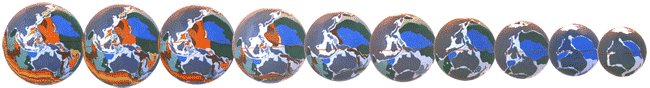
Indian Ocean
The sequential small Earth spreading history of the Indian Ocean shown
in Figure 28 shows three distinct phases of ocean floor spreading.
Early Jurassic passive margin extensional basins commenced in what are
now the Somali Basin adjacent to East Africa and an inferred Indian-Antarctican
Basin lying to the west of India.
This latter basin is inferred on spatial
grounds, separating Greater India, Asia and Antarctica.
Figure 28
Indian Ocean small Earth sequential spreading
history, from Early Jurassic to the Present. (Isochron data after CGMW
& UNESCO)
This early extensional phase continued until the Mid-Cretaceous with
the Somali Basin extending south, forming the Mozambique Channel between
Madagascar and Africa, to a triple junction south of Madagascar. The southern
extension of this triple junction joining with the newly opening South
Atlantic Basin near the Falkland Islands, and the eastern limb extending
the Indian-Antarctican Basin eastwards to join with the newly emerging
Wharton Basin adjacent to Western Australia.
Towards the end of this phase Madagascar, the Somali Basin and Mozambique
Channel were separated from India and thereafter remained part of the African
plate. This initial phase effectively marked the breakup and separation
of Eastern Gondwana from the African, Asian and Indian continents while
still retaining a land link between South America and Australia. Rifting
then began between Madagascar and India, and similarly intracratonic sedimentation
and extension initiated in the Eucla Basin between Australia and Antarctica,
along with passive extension in the adjoining South China Sea region.
The second phase of ocean floor spreading in the Indian Ocean region
(Figure 28) extended from the Mid-Cretaceous to the Paleocene. The
main feature of this second phase being a north-south widening of the Indian
Ocean, and abandonment of the earlier Somali Basin to Mozambique Channel
spreading axis in favour of spreading in the Arabian Sea, between Madagascar
and India.
With this north-south widening of the Indian Ocean there was an associated
northward displacement of Greater India relative to Antarctica, stretching
of the South East Asian, Philippines and Indonesian regions, and initiation
of the Java Trench. The Java Trench is here interpreted to be a zone of
sinistral translational displacement between the South East Asian region
and the Wharton Basin, relative to Australia.
A third Indian Ocean spreading phase (Figure 28) extended from
the post-Paleocene to the Present and was marked by development of the
Central Indian triple junction. A rapid northward migration of India relative
to Antarctica resulted in a sinistral rotation of India relative to Asia,
giving rise to up to 1400 kilometres of crustal foreshortening in the Himalayan
region and initiation of this ongoing orogenic event.
The Ninetyeast spreading axis, located in the eastern Indian Ocean region,
was abandoned during the Eocene in favour of a Southeast Indian Ocean spreading
axis. This axis extended southeastwards into the Eucla Basin, initiating
separation and northward migration of Australia relative to Antarctica.
The Gulf of Aden was formed during the Miocene as a result of North
and northwest extension of the Central Indian Ocean and Carlsberg ridges,
with a second triple junction forming at the western end of the Gulf of
Aden spreading axis. This triple junction is represented by the actively
spreading Red Sea axis, and East African Rift Valley system. In the south
Indian Ocean region the Southwest Indian spreading ridge split across older
spreading patterns and joined with the South Atlantic Ocean ridge system.
In conventional Indian Ocean reconstructions on a constant sized Earth
(eg. Patriat & Segoufin, 1988; Powell et al, 1988 ; Royer et
al, 1988; Scotese et al 1988 [Figure 23]; Chatterjee, 1992), a reassemblage
of the continents is crucial to an understanding of the breakup and dispersal
of Gondwana relative to Laurasia.
At the time of Pangaea conventional reconstruction of the Indian Ocean
necessitates a wide Tethyan Ocean between Gondwana and Laurasia (eg. Audley-Charles
et
al, 1988; Scotese et al, 1988). India is inferred to have migrated
north as an island continent (eg. Powell et al, 1988), from its
Africa- Madagascar-Antarctica configuration during the Jurassic, to collide
with the Asian continent along what is referred to as the "Indus Suture
Zone". This necessitated subduction of some 5000 kilometres of oceanic
crust in order to close the "Tethys Ocean" during the Mesozoic to Early
Cenozoic and create the Himalayan mountain belts during the Cenozoic (eg.
Valdiya, 1984).
In the sequential small Earth reconstructions of the Indian Ocean (Figure
28) it can be seen however that India remains in intimate contact with
Asia throughout the Mesozoic and Cenozoic (eg. Davidson, 1983; Stocklin,
1983) without the need to resort to a wide "Tethyan Ocean". It is considered
that the differential crustal extension and dextral motion of the Mediterranean
and European continental regions relative to Asia gave rise to a sympathetic
sinistral rotation of India relative to Asia during the Cenozoic.
This
resulted in complex thrusting and translational movement along the active
Himalayan orogenic belt, and complex sinistral translational motion along
the Java Trench.
Back to Contents
Pacific Ocean
The present day Pacific Ocean occupies nearly half the surface area
of the Earth and can be arbitrarily subdivided into north and south Pacific
regions along the present equator. In all conventional Late Triassic to
Mid-Jurassic reconstructions of Pangaea, on constant radius Earth models
(eg. Weijermars, 1986, 1989; Scotese et al, 1988 [Figure 23]), the
area of the Pacific Ocean is increased essentially by the sum of the areas
of the Atlantic and Indian Oceans, less that of the "Tethyan" and "Palaeoarctic"
Oceans (Owen, 1976).
This early Mesozoic Pacific Ocean ("Panthallassa Ocean", Scotese, 1987)
would have possessed an oceanic crust generated
 during the Triassic and
Palaeozoic at least (eg. Weijermars, 1989). The Mesozoic and Cenozoic history
would therefore be one of east-west and north-south contraction of the
oceanic area to the size of the modern Pacific Ocean, subduction of all
pre-Mesozoic crust, and subduction of a substantial quantity of oceanic
crust generated during the Mesozoic to Cenozoic.
during the Triassic and
Palaeozoic at least (eg. Weijermars, 1989). The Mesozoic and Cenozoic history
would therefore be one of east-west and north-south contraction of the
oceanic area to the size of the modern Pacific Ocean, subduction of all
pre-Mesozoic crust, and subduction of a substantial quantity of oceanic
crust generated during the Mesozoic to Cenozoic.
The small Earth sequential spreading history of the North Pacific Ocean
is shown in Figure 29 and South Pacific Ocean shown in Figure
30.
These figures suggest however that, when the circum-Pacific continents
are reassembled on small Earth models the necessity for such an expansive
pre-Mesozoic "Panthallassan Ocean", and similarly a "Tethyan Ocean", disappears.
Subduction of between 5,000 to 15,000 kilometers of Pacific oceanic lithosphere
(eg Larson & Pitman, 1972) also becomes unnecessary.
Figure 29
North Pacific Ocean small Earth sequential
spreading history, from Early Jurassic to the Present. (Isochron data after
CGMW & UNESCO)

Figure 30
South Pacific Ocean small Earth sequential
spreading history, from Early Jurassic to the Present. (Isochron data after
CGMW & UNESCO)
The Pacific Ocean small Earth sequential spreading history depicted
in Figure 29 and Figure 30 is considered to have commenced
as a northwest-southeast orientated extensional basin, located between
Eastern Australia and North America. This basin then progressively extended
south along the west coasts of North and South America during the Late
Triassic to Early Jurassic.
Four distinct phases to the evolution of the Pacific Ocean are evident.
The first phase being marked by a rapid southwest displacement of Australia,
and northeast-southwest extension of the North Pacific Ocean, relative
to North America. This resulted in preservation of a wide expanse of Jurassic
oceanic lithosphere in the north Pacific Ocean region, and extensive deposition
of passive extensional basin sedimentation in what is now the Coral Sea
and Lord Howe Rise regions of the southwest Pacific Ocean. Towards the
close of the Jurassic a deep ocean had extended southeast and south along
the west coast of South America, commencing oceanic development in the
South Pacific Ocean region.
The second phase of development lasted throughout the Mesozoic and was
characterised by an enlargement of the North Pacific Basin, extending southeast
into the South Pacific region. Oceanic lithosphere generated in the North
and South Pacific Oceans during this phase was generally arcuate shaped,
following the west coasts of North and South America and extending westwards,
separating the Coral Sea basin sediments from the North Pacific Ocean during
the Early Cretaceous.
Mid- to Late Cretaceous oceanic lithospheric continued to arc south
along the west coast of South America, initiating rifting between Antarctica
and New Zealand. As a result of this rifting the Coral Sea, Lord Howe Rise
and New Zealand complex has since remained attached to the North Pacific
Plate. The Pacific Ocean evolved during this interval with an asymmetric
spreading axis which followed and extended south along the west coastlines
of North and South America, west along the Antarctica coastline and, towards
the close of the Mesozoic, extending into the China Sea region.
The third phase of oceanic development was characterised by an initiation
and extension of symmetric style ocean floor spreading, commencing in the
Tasman Sea during the Paleocene, and extending east during the Eocene.
Elsewhere around the Pacific rim, ocean floor spreading continued to be
asymmetric, extending into the Coral Sea adjacent to Eastern Australia,
and into the China Sea regions.
The fourth phase lasted to the present and was characterised by a complex
interplay of oceanic crustal deformation, resulting from ongoing relief
of surface curvature of older oceanic crust. An extension of symmetric
style ocean floor spreading continued north, extending along the west coast
of North America to the present day location adjacent to California. Translational
crustal interaction between the North Pacific Ocean plate, Australia, South
East Asia and China gave rise to the island arc systems characteristic
of the western Pacific region. It is considered that this region represents
a complex interplay of transtension and transpressive plate motions in
an otherwise tensional règime. The Aleutian, Japanese, Philippine,
Solomon Islands, and similarly the Indonesian Islands, are all interpreted
to have resulted from extension, with associated volcanism related to translational
motion and interplate interaction.
This interpretation for the development of the Pacific Ocean based on
small Earth models cannot be reconciled with conventional reconstructions
on a constant sized Earth. This is because of the spatial and temporal
restrictions imposed by an Early Mesozoic "Panthallassan Ocean" (eg. Scotese,
1987; Scotese et al, 1988), and circum-Pacific subduction of oceanic
lithosphere (extensively covered in Ciric, 1983a; Scholl & Vallier,
1983; Beloussov, 1984; Hawkins et al, 1984; Spence, 1987; Lisowski,
1991; Phipps Morgan, 1991; von Huene & Scholl, 1991).
In the North Pacific Ocean the eastern oceanic regions are inferred
from conventional reconstructions to have been progressively overridden
by the North American continent as it was displaced westward and rotated,
since ocean floor spreading commenced in the Central Atlantic Ocean. The
apparent migration, relatively eastward, of the inferred North Pacific
spreading axis proceeded so far that it was largely overridden, and subsequently
dislocated, by the North American Pacific margin (eg. Scotese, 1987; Scotese
et
al, 1988).
In order to dispose of the excess oceanic lithosphere generated in the
Atlantic, Indian, Arctic and South Pacific Ocean spreading ridges the continental
margins of the circum-Pacific Ocean (Owen, 1976; Scotese, 1987) on conventional
reconstructions are inferred to consist of two main types. The eastern
and northern margins are marked by subduction zones along the Peru-Chile
Trench adjacent to South America; adjacent to North America; and the Aleutian
Trench subduction zone flanked by the Aleutian Island arc.
Ocean floor
within these subduction zones is then thrust down beneath the Andean cordillera,
and cordilleran fold belts of North America. Marginal oceanic basins are
characteristic of the western Pacific margin and separate the various West
Pacific island arcs, such as the Japanese Islands, from the Asian continent
to the west. Here, the principal subduction zones are inferred to lie east
of the island arcs and are marked by deep trenches such as the Marianas
Trench.
Along the southern margin of the Pacific, adjacent to Antarctica, no
active subduction zones are present, although Owen (1976) considered that
they may have existed during the Mesozoic. The western boundary of the
South Pacific Ocean has marginal oceanic basins, such as the Coral and
Tasman Seas, which separate the Australian continental margin, and active
subduction zones, marked by the Tongan and Kermadec Trenches, flank the
island arcs including New Zealand.
The reconstruction of the present Pacific Ocean on a constant sized
Earth (e.g. Figure 23) appears to work well, however major problems in
the development of the ocean occur during the Mesozoic and Cenozoic. During
this time the Pacific Ocean appears to have grown in area (Meservey 1969;
Owen, 1976, 1983c; Shields, 1979, 1983), particularly in the Late Cretaceous
and Cenozoic. Further problems are substantiated by studies of paleofloral
and faunal studies (Shields 1979, 1983; Smiley, 1992).
These studies suggest
that the Pacific Ocean was closed during the Jurassic with the North Pacific
Ocean first forming during the Early Jurassic, and South Pacific Ocean
forming during the Late Jurassic.
While the Pacific Ocean documentation (eg. Shields, 1979; Scotese, 1987;
Handschumacher et al, 1988; Sager et al, 1988; Sharman &
Risch, 1988) is extensive and can be interpreted in numerous ways, the
small Earth reconstructions shown in Figure 29 and Figure 30
demonstrate that it is feasible to have a closed Pacific Ocean in conjunction
with the closure of the Atlantic, Indian and Arctic Oceans, during the
Pre-Jurassic, on an Earth of much reduced radius. It is considered that
the oceanic magnetic spreading patterns (Larson et al, 1985; CGMW
& UNESCO, 1990) generated during exponential expansion of the Earth
negate the need for subduction of pre-existing Pacific oceanic crust. T
he
complex oceanic crustal patterns displayed are readily explained by asymmetric
to symmetric evolution of the Pacific Ocean spreading axes, and plate margin
regions explained by translational plate interaction during relief of surface
curvature.
Back to Contents
South East Asian basins
The South East Asian region comprises the Philippine, South China, Celebes,
Banda and Java Seas, and will be treated
 separately to the South Pacific
Coral and Tasman Sea regions. Using conventional reconstructions on a constant
sized Earth (Scotese et al, 1988, Figure 23) these areas are interpreted
as representing marginal oceanic basins, separating the various
island
arcs and zones of crustal subduction marked by deep trenches, and formed
by back-arc spreading (Owen, 1976; Seno & Maruyama, 1984; Gray &
Norton, 1988).
separately to the South Pacific
Coral and Tasman Sea regions. Using conventional reconstructions on a constant
sized Earth (Scotese et al, 1988, Figure 23) these areas are interpreted
as representing marginal oceanic basins, separating the various
island
arcs and zones of crustal subduction marked by deep trenches, and formed
by back-arc spreading (Owen, 1976; Seno & Maruyama, 1984; Gray &
Norton, 1988).
Small Earth sequential reconstructions of the South East Asian region
are shown in Figure 31 for models dating from the Jurassic to the
present. The region is interpreted to be an area of passive basinal extension,
and complex dextral extension and unfurling of South East Asia, primarily
resulting from southeast-northwest crustal extension between Asia and Australia.
This Southeast-northwest crustal extension in the South East Asian region
gave rise to the South China, Celebes and Banda Seas during the Late Cretaceous
to Pliocene.
Figure 31
South East Asian small Earth sequential
spreading history, from Early Jurassic to the Present. (Isochron data after
CGMW & UNESCO)
The key elements to the development of the South East Asian region are
considered to be: a northeast-southwest extension of the Asian mainland
resulting from relief of surface curvature during Earth expansion; southeast
migration of Australia relative to Asia and; a complex plate margin interaction
giving rise to island arc volcanism.
The South East Asian region can be treated in two main phases. The first
phase representing passive basinal extension, shallow basinal sedimentation,
fragmentation, and elongation of a Late Triassic to Early Jurassic landmass
lasting until the Late Cretaceous.
The second phase is marked by an eastward displacement of the North
Pacific Ocean plate, relative to Asia, giving rise to emplacement of oceanic
crust in the Philippine Basin during the Palaeocene, and east and northeast
spreading of the Philippine Basin to the present.
Back to Contents
Southwest Pacific
The sequential reconstruction of the South Pacific region for an Earth
undergoing expansion since the Jurassic is also shown in Figure 31.
The region is structurally complex and reconstructions shown are conjectural.
Modifications to the reconstruction may be necessary in time, as new data
become available.
As it stands, the region is considered intimately related to development
of the South Pacific Ocean, detailed previously, and is particularly influenced
by dextral translational motion and interplate interaction along the margin
of the Indo-Australian and Pacific plates. This contrasts strongly with
the thrust/subduction model portrayed in conventional reconstructions (eg.
Gray & Norton, 1988).
The early development of the Southeast Pacific region commenced with
passive basin extension and deposition of extensive shallow basinal sediments
during the Jurassic. West Antarctica and New Zealand are interpreted to
have been located between Australia and South America during this time,
with West Antarctica rotating sinistrally to its present location from
the Jurassic to the present. [Additional modeling to date suggests that
the rotation of West Antarctica may not have been quite as much as shown
on Figure 31].
Asymmetric spreading in the South Pacific Ocean extended westwards during
the Cretaceous, opening the Tasman Sea and isolating the Lord Howe Rise
and New Zealand from Antarctica during the Early Cretaceous.
Symmetric ocean floor spreading continued east to South America, and
west, initiating rifting between Australia and Antarctica, during the Paleocene,
while asymmetric spreading continued to spread around the Pacific Ocean
rim into the Coral Sea region.
Complex plate interaction and adjustment, interpreted to have resulted
from changing relief of surface curvature of older oceanic crust, resulted
in dextral translational motion along the South Solomon and New Hebrides
trench/arc systems. In addition, rapid symmetric ocean floor spreading
in the South Pacific Ocean resulted in a dextral rotation of the
New Zealand/Lord Howe Rise plate regions. This South Pacific Ocean plate
motion initiated spreading along the Kermadec/Tongan tench/arc system during
the Early Miocene, and up to 1000 kilometres of translation along the Alpine
fault system of New Zealand.
Both the South East Asian and South Pacific basin regions cannot be
reconciled with conventional reconstructions (eg Audley-Charles et al,
1988; Gray & Norton, 1988; Scotese et al, 1988) on a constant
radius Earth.
Both regions are interpreted from small Earth models to have
resulted from a progressive evolution of the Pacific Ocean, interplate
interaction accompanied by translational displacements and island arc volcanism,
and continental extension due to changing relief of curvature during Earth
expansion.
Back to Contents
Discussion
The main aim of this section has been to demonstrate that accurate
Post Jurassic small Earth reconstructions can be made by constraining both
palaeoradius and plate configuration using oceanic magnetic isochron data,
such as Larson
et al (1985) and (CGMW & UNESCO, 1990).
The primary
assumption being that, the magnetic isochron data represents oceanic
lithosphere which has been fully fixed in the rock record and has not been
removed by subduction processes. The only premise being that, continental
crust may undergo spherical adjustments to allow for relief of surface
curvature. It is reiterated that if these basic assumptions are wrong
then consideration must be given to alternative theories such as plate
tectonics, or to compromise theories such as Owen (1976).
It is emphasised also that, although conventional reconstructions
of individual regions on a constant sized Earth can achieve a high degree
of fit together, in most cases they obscure the fact that crustal development
and displacement in one region of the Earth affects all other areas. Problems
of misfit in one area on conventional reconstructions cannot be conveniently
transferred to an adjacent region and then ignored.
Reconstructions of Pangaea on a constant radius Earth (eg. Weijermars,
1986; Scotese et al, 1988 [Figure 23]) are considered to be inconsistent
with the geological and oceanic magnetic isochron spreading data of Larson
et
al (1988) and CGMW & UNESCO (1990). Reconstructions assuming a
constant Earth radius require that the Arctic, the Caribbean, Mediterranean
and western Pacific, in particular, must contract in area during the Mesozoic
and Cenozoic. In reality, the geological and oceanic magnetic isochron
spreading data show that they have expanded their areas during this time.
These conventional reconstructions postulate a large Arctic Ocean long
before the present day Arctic Ocean basins started to develop. Geological
evidence however negates the presence of former subduction zones around
the Arctic Ocean needed to absorb this postulated pre-Early Mesozoic crust
(Rowley & Lottes, 1988).
Reconstructions of the Caribbean and Central American regions are also
contrary to the geological and spreading data available, with Pindell &
Barnett (1987) suggesting that the Caribbean plate is a preserved piece
of the Pacific Ocean Farallon plate, and therefore allochthonous with respect
to North and South America.
The Mediterranean region is portrayed as evolving from a number of microplates
drifting between Africa and Eurasia during the Mesozoic closure of a triangular
shaped "Tethys Ocean". The subsequent Mesozoic and Cenozoic history of
this region is depicted as a progressive elimination of this "Tethyan Ocean",
by subduction or thrusting of its pre-Late Triassic lithospheric crust
(Owen, 1976).
The Mesozoic and Cenozoic ocean floor spreading history of the eastern
Indian Ocean and west Pacific, together with tectonic trends (Gahagan et
al, 1988), preclude completely the wide "Tethyan" oceanic gap between
Australia and New Guinea on the one side and Indonesia, the Philippines
and Southeast Asia on the other, which is obligatory for Pangaean reconstructions
on a globe of modern dimensions (Owen 1976, 1983c).
For the small Earth sequential histories depicted for each ocean discussed
it is significant to note that all of the ocean basins commenced during
the Late Triassic to Early Jurassic. These then evolved as shallow passive
margin basins (Figures 24, 25, 26, 27, 28, 29, 30 and 31), prior
to development of modern deep oceanic basins. Not until the Mesozoic to
Cenozoic transition
 did modern mid-oceanic type spreading ridges become
established throughout all of the major ocean basins.
did modern mid-oceanic type spreading ridges become
established throughout all of the major ocean basins.
This consistency
of timing and sequence of basinal development agrees with the constraints
imposed by the geological evidence, tectonic style and oceanic magnetic
isochron spreading data.
The Jurassic small Earth models shown in each of the figures indicate
that, Earth expansion during the Late Triassic to Early Jurassic initiated
in the north polar Arctic Ocean (Figure 24) and south polar South
Pacific/Atlantic Ocean regions (Figure 25). These initiated as passive
margin extensional basins, accompanied by extensive shallow basinal sedimentation.
This sedimentation may have possibly masked exposure of Early Jurassic
to Triassic oceanic lithosphere and small Earth modeling here tends to
confirm this observation.
Antarctic
Animation
Figure 32
Antarctic small Earth sequential spreading
history, from Early Jurassic to the Present. (Isochron data after CGMW
& UNESCO)
By Late Jurassic the primary extensional basin spreading
centers shifted
from a polar to a meridional position, centred on the Central Atlantic
and Pacific Ocean regions. Continental crustal dilation, rupture and subsequent
rifting then gave rise to emplacement of Early Jurassic oceanic lithosphere
in the newly emerging North Pacific Ocean, and Late Jurassic oceanic lithosphere
in the Central Atlantic and Indian Oceans.
Throughout the Cretaceous all of the ocean basins continued to enlarge
in what are interpreted to be passive margin basin settings. These then
extended their spreading axes as either: asymmetric spreading ridges along
the perimeters of the North and South Pacific Oceans; as symmetric spreading
ridges in the North and South Atlantic or; a combination of both asymmetric
and symmetric type spreading ridges in the Indian Ocean.

The Cenozoic was characterised by initiation and extension of modern
day symmetrical spreading axes throughout all of the major ocean basins.
This was accompanied by rifting and isolation of continental areas such
as Australia, Antarctica and Greenland, as well as breaching of land links
between Antarctica and Australia, Antarctica and South America, North America
and Europe, and Africa and Europe.
Relief of surface curvature of oceanic lithosphere in the Pacific Ocean
in particular gave rise to complex interplate translational motions and
island arc volcanism, particularly along the western Pacific Ocean island
arc/trench margins.
The apparent overriding of the North Pacific Ocean plate by North America,
often quoted as a classic example of plate consumption by subduction is
here refuted. Instead, by consideration of the spherical spatial and temporal
plate motion history of the Earth as a whole, this region is interpreted
as a region of Mesozoic asymmetric spreading history evolving towards Cenozoic
symmetric type spreading
Figure 33
South Pacific Ocean small Earth sequential
spreading history, from Oligocene to the Present. (Isochron data after
CGMW & UNESCO)
The future plate motion history of the Earth appears to be continued
fragmentation, rifting and separation of the larger continents, in particular
between North America and South America, Africa and Europe, and North America
and Europe.
Back to Contents