|

With all this, you might just be
wondering exactly what shape is the “Triangle.”
You would not be the first.
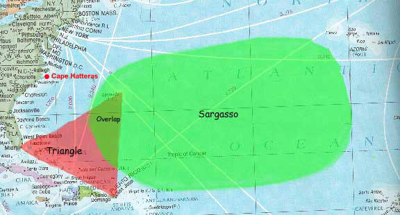
No two researchers or authors ever agreed, although most were in accord that
the Sargasso Sea and the area of the strict triangle between Miami, San Juan
and Bermuda embodies the greatest part.
Many have proposed an alternate nodal point, that is, Norfolk, Virginia,
calling to mind that Cape Hatteras has been known for centuries as the
“Graveyard of the Atlantic.” However, graveyard implies a burial place for
ships, where their rotting carcasses can still be seen.
And that is quite
true of Cape Hatteras. Many famous vessels can still be found on the bottom,
slammed by the great gales and thrashed by the reefs, like the Union
ironclad, Monitor, which foundered here.
But disappearance means no trace is
found, implying destruction on a complete and total scale, something beyond
even the great reefs and shoals of Cape Hatteras and her wild seas.
The seas off Norfolk are, of course, the Gulf Stream and the routes to
Bermuda or south to the Bahamas and Caribbean.
All the ships coming or going
to Panama and the East Coast pass by here, to Canada, New York, off to
Europe, wherever. The seas of the Carolinas are perfectly juxtapositioned to
put them in daily interplay with the greatest seaways of the Triangle.
But though these are hard waters, several mysteries share an uneasy grave
here with the rusted relics of the sea.
The freighter Southern Districts
passed by here in 1954 and vanished utterly, as have several yachts en route
to Bermuda, like Windfall or Dancing Feathers or L’Avenir. The 5 masted
cargo schooner, Carroll A. Derring, ghosted up upon the shores here in 1921,
totally shipshape but mysteriously deserted.
Captain John M. Waters, once head of Coast Guard Search and Rescue in
Washington D.C., wrote in his Rescue at Sea (Van Nostrand, 1966) about the
curious disappearance of a Coast Guard commander, James Reed Hinnant. He was
commander of the Coast Guard cutter Rockaway. It was a balmy night.
About
300 miles off Cape Hatteras, near the Sargasso Sea, the Rockaway’s propeller
became fouled. He ordered diving gear and search lights. He was an
experienced diver and was even commended for his diving under fire in the
Philippines during WWII.
Suited up, he went over the side to the propeller.
Dozens manned the rails and watched the brightened water, glowing from the
underwater spot light. After a while they tugged his line to see if he was
OK. However, there was no response.
The OD ordered it hauled in, yet it
would not budge.
The search for Hinnant was intense, but in the end it offered no clues but
this: his air hose and line were found fouled in the propeller. Capt. Waters
finishes the narrative:
“What could have happened to an experienced diver
only 10 feet below the surface? Had his retaining line and air hose fouled?
If so, he had only to release his weighted belt, take a deep pull of air,
flip off the mask, and surface. It is a simple and basic maneuver for a
diver. Many speculated that he had been hit by a shark.
There are many large
man eaters in that area, and they are attracted to light. Commander Hinnant
had been working beneath a large light, and a shark could have come in while
he was busy working on the screw. However, no sharks were seen at any time,
and there was no disturbance in the water, nor any evidence of a struggle.
No one saw him surface, though many men were watching the water at all
times. What happened to him that night will never be known.”
Mystery also befell a Navy KA-6 attack bomber in 1978 while 100 miles off
Norfolk.
The last words of the pilot, Lieutenant Paul Smyth, were: “Stand
By, we have a problem right now . . .” In the radar plot of the carrier John
F. Kennedy (Smyth’s intended destination), they continued to follow the jet
and attempt contact for 10 minutes without any response. Then the KA-6
suddenly vanished.
Shortly thereafter, another blip reappeared, tracking in
another direction, away from the carrier, then vanished off the radar scope
forever. There was never a trace found of the jet, nor any reason why Smyth
answered no calls in that period of time; no reason why there was no
automatic alarm, nor why they could not eject (ejection also triggers an
auto-alarm) And what was that second blip?
Three marines and three children departed in a launch off Surf City, North
Carolina, in 1985, only to vanish. The launch was later found . . . at the
end of a line of six unused life jackets. No explanation was found, and the
launch was towed back in.
Along with dozens of more examples, far too many to recite without being
repetitious, Norfolk or the Virginia Capes offer themselves as a point in
the “Triangle.” Premier sailor, Alan Villiers, noted this in his Posted
Missing (Scribners 1974) saying the Triangle lay between
Key West,
Chesapeake Bay and Bermuda.
|
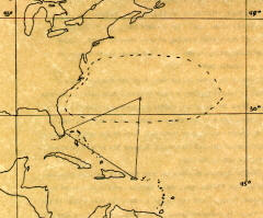
The standard triangle of
journalist Vincent Gaddis. Above this is superimposed the “vile
vortice” of biologist Ivan Sanderson. While Gaddis sought to
catalogue sea mysteries, Sanderson tried to use them to verify his
theories of areas of electromagnetic anomalies and underwater UFO
civilizations. |
However, it was Vincent
Gaddis who first tried to give shape to the area. In 1964 he wrote
an article for Argosy magazine, entitled “The Mystery of the Deadly
Bermuda Triangle.”
From that day on the sea of old mariner lore
began to be called by no other name. It was he who offered Miami,
San Juan, and Bermuda as the three nodal points.
Yet it wasn’t long
before this was challenged. John Wallace Spencer, from whom the term
“Limbo of the Lost” originates, wrote the first entire book devoted
to the subject (Limbo of the Lost, Phillips, 1969).
He believed it extended
from,
“. . . Cape May, New Jersey, to the edge of the continental
shelf. Following the shelf around Florida into the Gulf of Mexico,
it continues through Cuba, Jamaica, Haiti, the Dominican Republic,
Puerto Rico, and other islands of the West Indies, and then comes up
again through the Bahamas... then up once more to
Bermuda.”
Naturalist, Ivan T. Sanderson, who studied several phenomena from
Bigfoot to UFOs, held a different view. He observed:
“The popular
idea has been that there is a roughly triangular area with sides
running from Bermuda to central Florida and thence to
Puerto Rico...
This is a glamorous
notion, but on proper analysis it does not stand up. It is not a
triangle, and its periphery is much greater than the one outlined
above.
In fact, the area... forms a large, sort of lozenge shaped
area... which extends from about 30� to 40� north latitude, and
from about 55� to 85� west.”
|
|
Author Richard Winer offered yet
another novel shape, stating in his Devil’s Triangle (1974):
“The Devil’s Triangle is not a triangle at all. It is a
trapezium, a four
sided area in which no two sides or angles are the same.”
He
concludes:
“And the first four letters of the word
trapezium more
than accurately describe it.”
There are any number of
other novel shapes which promote an author’s imagination more than
his knowledge of the Bermuda Triangle. But John Godwin (This
Baffling World) not only identified the area most accurately, but
also gave it its most humorous name, calling it the “Hoodoo Sea.”
To
add injury to insult, Vincent Gaddis later retracted his statement
because it implied the phenomenon had “boundaries,” although it is
hard to imagine how there can be a phenomenon if there are no
boundaries.
|
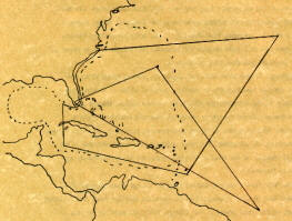
Three varied shapes: The
Trapezium of Richard Winer extends far into the Atlantic and
Sargasso Sea; Charles Berlitz’s triangle extends close to South
America; and the broken line represents John Spencer’s “Limbo of the
Lost.” |
|
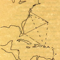
Drawing lines from the
major nodel points of Bermuda, Miami, San Juan and Norfolk creates
the “Sea of the Four Triangles.” This about covers John Godwin’s
“Hoodoo Sea.” |
It is therefore up to
the reader to decide, based upon the maps, which shape he/she
prefers.
One thing is certain: the “Triangle” is not a triangle at
all, but an amorphous body of water in the proximity of the
Sargasso Sea and West Indies.
|
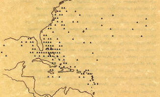
A rough estimate of
where major losses (marked by a triangle) may have occurred, based
on last known position or course followed.
|
|