|
from
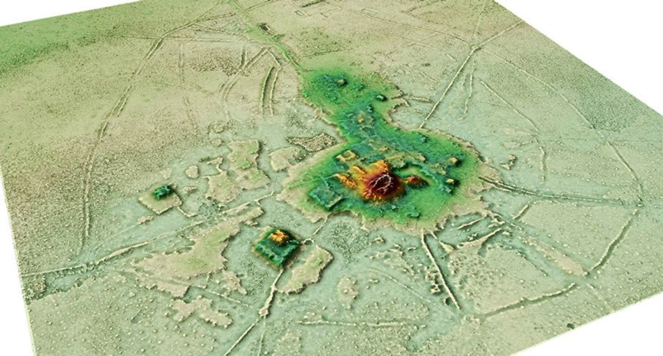
Ancient-Origins Website Screenshot from a 3D animation of the Crotoca site where evidence of the lost Amazonian civilization has been found.
Source: Heiko Prümers DAI / CC BY-NC-ND have used Lidar to identify a series of raised platforms and pyramids. Interwoven by a complex hydrological network, these abandoned sacred sites are relics
from a lost
Amazonian civilization...
Between 500 and 1400 AD, farmers in this lowland tropical savanna built a complex network of cities and towns amidst almost one thousand kilometers of canals and mud causeways.
Now, scientists flying
Lidar scanners have revealed evidence of hitherto undiscovered
settlements built by a "lost pre-Hispanic civilization".
Arstechnica explains that history has forgotten what these people called themselves, so the Casarabe people are named after the nearby colonial town.
A new study (Lidar reveals pre-Hispanic low-density urbanism in the Bolivian Amazon) published in the journal Nature claims to resolve a long-standing scientific debate about whether this region could have sustained a large population in ancient times, or not.
Previous surveys in the Llanos de Mojos identified hundreds of mounds. Most of these were concentrated within a 4,500 square kilometer section of plains around the modern Bolivian town of Casarabe.
However, 16th century Spanish missionaries only recorded finding small, isolated communities of farmers living in the region.
Study lead author, Heiko Prümers, an archaeologist at the German Archaeological Institute in Bonn, told Live Science that scientists in the 1960s interpreted these earthen mounds,
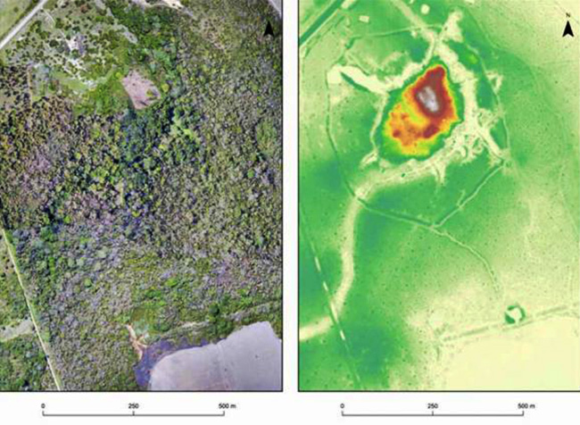
Two images of exactly the same area of the Salvatierra site. Left: a photo mosaic from drone footage; right: Lidar image. (Heiko Prümers / DAI)
Mundane Mounds Become Ceremonial Pyramids With Lidar
Penetrating the dense Amazonian vegetation with airborne Lidar, the team of researchers have successfully identified the nature of several unknown mounds in areas now known as Cotoca and Landívar.
They turned out to not be natural piles of dirt, but vast ceremonial centers with,
The new paper describes two large Casarabe settlements that stood central in a network of roads, causeways, reservoirs and canals.
Contrary to Spanish accounts, according to Prümers, this region was,
The archaeology, it turns out, is so thick in this region that earlier scientists thought the proliferation of mounds must have been geological!
Prümers concluded that Casarabe people had instituted,
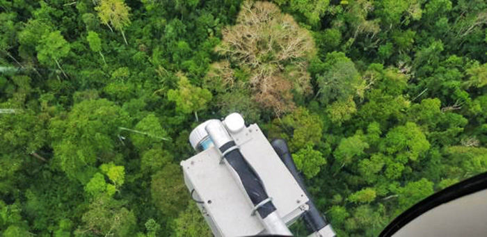
Top view of the Lidar sensor mounted in the helicopter while scanning the tropical forest.
(Jose Iriarte DAI / CC BY-NC-ND )
Finding an Amazonian
Civilization from the Sky
While the two major sites at Cotoca and Landívar were known about previously,
It was revealed that
these two mega-settlements were joined by a complex matrix of roads
and causeways forming loose concentric circles.
Prümers said this complex-hydrological system perhaps controlled seasonal floods and enabled the farming of maize and other crops in higher areas, while fish might have been farmed in lower flooded parts of the landscape.
All Good Things Must
Come to an End
This predominant
astronomical alignment, along with the ceremonial pyramid structures
suggests a well-developed cosmovision, or community wide religious
beliefs
This collapse occurred more than a century before the Spanish conquistadors arrived.
Thus, the pyramids
erected in the honor of ancient sky gods, it would seem, had lost
their life blood through droughts a long time before the dragons
arrived to scorch their land.
|