|
PART I - GEOGRAPHIC RELATIONSHIPS
The
Great Pyramid is
aligned with
Machu Picchu, the
Nazca lines and
Easter Island along a
straight line around the center of the Earth, within a margin of
error of less than one tenth of one degree of latitude.
Other sites
of ancient construction that are also within one tenth of one degree
of this line include:
-
Perseopolis, the capital city of
ancient Persia
-
Mohenjo Daro,
the ancient capital city of the Indus Valley
-
the lost city of
Petra.
The Ancient Sumerian city of Ur and the temples at
Angkor Wat
are within one degree of latitude of this line.
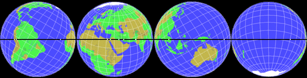
The alignment of
these sites is easily observable on a globe of the Earth with a
horizon ring. If you line up any two of these sites on the horizon
ring, all of the sites will be right on the horizon ring. 3-D world
atlas software programs can also draw this line around the Earth.
Start on the Equator, at the mouth of the Amazon River, at 49° 17'
West Longitude; go to 30° 18' North Latitude, 40° 43' East
Longitude, in the Middle East, which is the maximum latitude the
line touches.
Then go to the Equator at,
-
130° 43' East Longitude,
near the Northwest tip of New Guinea
-
then to 30° 18' South
Latitude, 139° 17' West Longitude, in the South Pacific
-
then
back to 49° 17' West Longitude, at the Equator
|
Centered on
0.00° N, 49° 17' W |
Centered on
30° 18' N, 40° 43' E |
Centered on
0.00° N, 130° 43' E |
Centered on
30° 18' S, 139° 17' W |
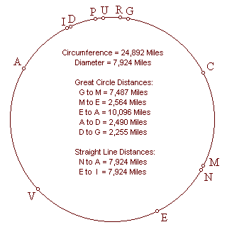
The circumference of this line around the center of the Earth is
24,892 miles. Along this line, the great circle distance from,
-
the Great Pyramid to Machupicchu is 7,487
miles, 30.0% of the circumference.
-
Machupicchu is 2,564 miles from Easter Island,
10.3%.
-
Easter Island is 10,096 miles from Angkor Wat,
40.6%.
-
Angkor Wat is 2,490 miles from Mohenjo Daro,
10.0%.
-
Mohenjo Daro is 2255 miles from from the Great
Pyramid, 9.1%.
In addition to calculating the distances between these sites as a
percentage of the circumference of the Earth, the distances may also
be calculated in degrees of the 360° circumference, by multiplying
the percentage by 3.6.
For example, the Great Pyramid is 108° away
from Machupicchu.
Angkor Wat and Angkor Thom were
constructed at a time when 72 temples were built across the Angkor
Plain. The Angkor temple at Prassat Preah Vihear, 90 miles Northeast
of Angkor Wat, is within one tenth of one degree of the line. Like
Machupicchu, the temple at
Prassat Preah Vihear was built on the edge of a
mountaintop. The first temples built around Angkor are near the
city of Rolous, Southeast of Angkor Wat.
The temples near Rolous are
also thought to have been built on foundations constructed at a much
earlier time.
Halfway between Angkor Wat and the Great Pyramid
is the Indus Valley, the city of Mohenjo Daro, and the
unexcavated city of Ganweriwala, which is East of Mohenjo Daro, and thought to
be just as large. Both of these sites are on the line between
Angkor and the
Great Pyramid. The Indus Valley is also antipodal
to Easter Island.
It is an interesting coincidence
concerning these two sites, opposite each other on Earth, that of
the few ancient written languages of the world that remain
undeciphered, two are Indus Valley Script and Rongorongo, the written language of ancient Easter
Island. The world's first known written languages,
Egyptian Hieroglyphics and Sumerian Cuneiform, were also
developed along this line of ancient sites. The Jewish, Christian,
Muslim, Hindu, Brahman and Buddhist religions, as well as ancient
Egyptian and Peruvian religions, were also developed along this
line.
Anatom Island is the southernmost Island in the new
Republic of Vanuatu, formerly known as the New Hebrides. Anatom
Island is exactly halfway between Easter Island and Angkor Wat 5,048
miles each way, or 20.3% of the circumference of the Earth. Stone
ruins on Anatom Island
once housed the largest missionary church in the southern hemisphere.
The line crosses over the source and the mouth of the Amazon,
the
mouth of the Nile, the mouth of the
Tigris-Euphrates, the
Indus River
and the Bay of Bengal near the mouth of the Ganges.
The line also crosses over a number of areas of the world that are
largely unexplored or unexcavated, including the Sahara
Desert, the Brazilian Rainforest, the highlands of New Guinea, and
underwater areas of the North Atlantic Ocean, the South Pacific
Ocean and the South China Sea.
For example, the midway point between
the Great Pyramid and Machupicchu is in
the North Atlantic Ocean, less than one degree south of the Cape
Verde Islands. This is also the midway point between Easter
Island and the Indus Valley.
Although the Cape Verde Islands were found to be uninhabited when
they were rediscovered in 1460 A.D., maps and geographical
descriptions for the past 2000 years have shown this location to be
the home of ancient island civilizations, including maps
showing this location to be the site of
Atlantis. In Plato's account of Atlantis, there
was a mountainous region north of the city.
Are the higher
elevations of those mountains now the Cape Verde Islands?
Back to Contents
PART 2 - GOLDEN SECTION SITES - ANGKOR, THE GREAT PYRAMID &
NAZCA
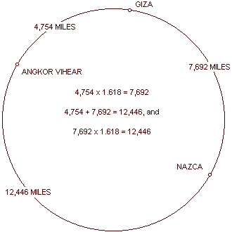
Angkor Wat is 4,745 miles from the Great Pyramid
and the Great Pyramid is 7,677 miles from Nazca.
This
is a precise expression of ?, the Golden Section:
4,745 x
1.618 = 7,677
|
Ninety miles northeast of
Angkor Wat are the Angkor temples at Prassat Preah
Vihear. Prassat Vihear is 4754 miles from the Great
Pyramid.
The line of ancient sites
crosses over the Great Pyramid and
Angkor Vihear.
Twenty five miles
northwest of the city of
Nazca is a figure known as the Hummingbird.
The Hummingbird is
7,692 miles from the
Great Pyramid.
The line of ancient sites
also crosses over the
Hummingbird.
The relationship between the distances from Angkor Vihear
to the
Great Pyramid and from the Great Pyramid to the
Nazcan Hummingbird is also a precise expression of
phi:
4,754 x 1.618 = 7,692
|
 |
Because the distance from the Hummingbird to Angkor
Vihear
is one-half of the circumference of the earth, two Golden
Section relationships
between these sites are shown by the circumference of the earth along
the line of ancient sites:
These Golden Section relationships may also be diagramed on a
straight line
The line of ancient sites
is a line, from the perspective of the illustration in
Part One, and it is a circle, from the perspective of the
illustration in
Part Six.
The line and the circle
are found in the Greek letter phi and the number 10.
Zero and one are also the first two numbers and the only two numbers
in the binary code.
The phi relationships between these sites are reflected
repeatedly in the first 500 Fibonacci numbers. The
first three prime numbers, 2, 3 and 5, approximate the intervals
along the circumference of 20%, 30% and 50%, between these three
sites.
This same percentage of the circumference relationship,
accurate to three digits, is found in Fibonacci numbers 137-139:
|
|
Percentage of
circumference:
|
Distance
between sites:
|
First three digits of
Fibonacci numbers:
|
First five digits of
Fibonacci numbers:
|
|
Angkor to Giza:
|
19.1%
|
4,754 miles
|
#137: 191... (Prime)
|
#359: 47542... (Prime)
|
|
Giza to Nazca:
|
30.9%
|
7,692 miles
|
#138: 309...
|
#360: 76924...
|
|
Nazca to Angkor:
|
50.0%
|
12,446 miles
|
#139: 500...
|
#361: 12446...
|
The next prime Fibonacci number after #137 is #359.
The distances between these sites, in miles, is reflected
by Fibocacci numbers 359-361, accurately to five digits.
Back to Contents
PART 3 - LINES
THROUGH THE EARTH
|
The line of ancient sites
may be viewed as a circle because all of the sites are on a straight
line around the center of the Earth.
The intervals
between the sites are based on their great circle distances from
each other.
The circle is oriented so that the two points where the circle crosses
the equator are on the horizontal axis, and the two points where the
circle reaches its greatest latitudes are on the vertical axis.
|
G = The Great
Pyramid
C = Cape Verde Islands
M = Machupicchu
N = Nazca
E = Easter Island
V = Anatom Island
|
A = Angkor Wat
I = Indus Valley
D = Mohenjo Daro
P = Perseopolis
U = Ur
R = Petra
|
|
 |
|
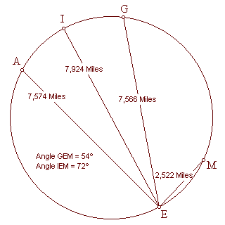 |
Straight lines may be
drawn through the Earth, connecting
Easter Island to Machupicchu, the
Great Pyramid,
Angkor Wat, and the Indus Valley
(antipodal to Easter Island).
The straight line distance, through the Earth, from Angkor Wat
to
Easter Island (7,574 miles), plus the straight line
distance from
Easter Island to Macchupicchu (2,522
miles), equals the great circle distance from Angkor Wat to Easter
Island (10,096 miles).
The straight line distance from the Great Pyramid to Easter Island
(7,566 miles) is three times the straight line distance from Easter
Island to Machupicchu (2,522 miles).
The straight line distance from Easter Island to its
antipodal point in the Indus Valley (7,924 miles),
which is also the diameter of the Earth, is 3.1416 times the
straight line distance from Easter Island to Machupicchu (2,522
miles), a precise expression of phi. |
Since the circumference of the Earth is also 3.1416 times the diameter
of the Earth, the straight line distance from Easter Island to Machupicchu times pi˛ equals the circumference of the Earth.
The angle formed by the lines from Easter Island to Machupicchu, and to the Indus Valley, is 72°.
The angle formed by the lines from Easter Island to Machupicchu, and
to the Great Pyramid, is 54°.
|
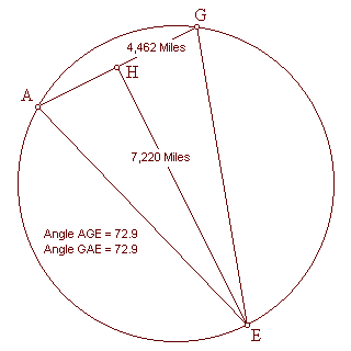
Lines connecting
Easter Island, the
Great Pyramid, and the Angkor temples near Rolous,
form an isosceles triangle with base angles of 72.9°. The base of
this triangle (AG) is 4462 miles long.
The height of this triangle
(HE) is 7220 miles long. The length of the base of the triangle
times phi equals the height of the triangle: 4,462
miles x 1.618 = 7,220 miles
|
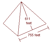 |
The length of the base of
each face of the
Great Pyramid is 755.6 feet.
The slant height of each
face is 611 feet. |
One half of the length of
the base times phi equals the slant height of the
Great Pyramid:
755.6 feet ÷ 2 = 377.8
feet
377.8 feet x 1.618 = 611 feet
|
 |
The ratio of the base to the slant height of the Great Pyramid
is exactly two times the ratio of the base to the height of the
triangle formed by through the earth straight lines connecting the
Great Pyramid, Angkor and Easter Island.
|
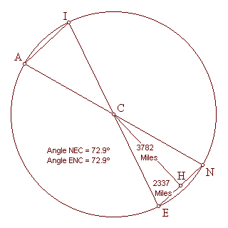 |
Lines connecting Easter
Island with it's antipodal point in the
Indus Valley, Nazca with it's antipodal
point at Angkor, Easter Island with Nazca and Angkor with the Indus
Valley, form two isosceles triangles with base angles of 72.9°.
With the same angular
dimensions as the triangle formed by Easter Island, Angkor and the Great Pyramid, the length of
the bases of these triangles times phi also equals the
height of these triangles:
2,337 miles x 1.618 =
3,782 miles
The ratio of the base to
the slant height of the
Great Pyramid is also exactly two times the ratio of the
base to the height of the triangles formed by through the earth
straight lines connecting Easter Island,
Nazca and the center of the Earth, and Angkor,
the
Indus Valley and the center of the Earth. |
Because the distance
between the Great Pyramid and Angkor is very nearly
20% of the circumference, they are very nearly 72° apart, along the
circle.
Because the distance from the Great Pyramid to
Easter Island is very nearly 40% of the circumference,
and the distance from
Angkor to Easter Island is very nearly 40%
of the circumference, the Great Pyramid and Angkor are both very
nearly 144° away from Easter Island, along the circle.
The number 72, and to a lesser extent the numbers 54,
108, and 144, have been associated with the designs of these
sites, particularly at the Great Pyramid and
Angkor. The ratio of the height and the perimeter of the
Great Pyramid, to the size of the Earth, is a multiple of 72.
The
number of temples built around Angkor is 72, and the number 54 is
reflected in the numbers of statuary in the temples at Angkor. The
use of these numbers is also prevalent in ancient writings and
folklore surrounding these sites. The number 54 is itself a factor
of 72, in that 72 plus ˝ of 72, or 36, equals 108, which divided by
two equals 54.
The number 72 is also associated with the astronomical
phenomenon known as precession, because 72
years is the length of time it takes for the constellations
to move one degree due to precession. This has
been offered as an explanation for the use of these numbers,
suggesting that the builders of these sites were aware of the
precession of the equinoxes.
In the 2nd century B.C., the Greek
mathematician, Archimedes, wrote an article entitled The
Sand Reckoner, in which he cited earlier Greek mathematicians
(like Archimedes, they had studied in Alexandria and Heliopolis) who
had calculated that the Sun occupied 1/720 of the circle of the
constellations. This may be an additional, or alternative,
explanation for the prevalence of the number 72, and its multiples
and factors, found in these sites.
In any event, the existence of
these numbers in the geometric relationships between these sites is
complementary to the use of these numbers in their internal designs.
Back to Contents
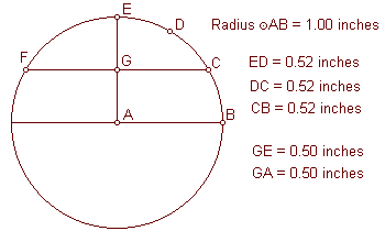
PART 4 - THE GREAT PYRAMID AND THE 30th PARALLEL
|
This circle has a
different orientation than the previous diagrams and is two inches
in diameter.
The horizontal axis is the
Equator, FC is the 30th parallel, D is 60° North latitude and E is
the North Pole.
The 30th parallel is
exactly one-third of the great circle distance from the Equator to
the North Pole, and it is located at exactly one-half of the height
of the Northern Hemisphere.
Like the Great
Pyramid, the maximum latitude of the line of ancient
sites is very close to the 30th parallel. |
 |
|
 |
This diagram illustrates
that the relationship of the 30th parallel to the circumference of
the Earth is the geometric relationship known as the Vesica
Pisces.
In relation to the lower
circumference, DE is at 30° N latitude.
In relation to the upper
circumference, DE is at 30° S latitude.
The ratio between the
straight line distance of the 30th parallel and the radius of the
Earth is 1.732 to one. 1.732 is the square root of three. |
|
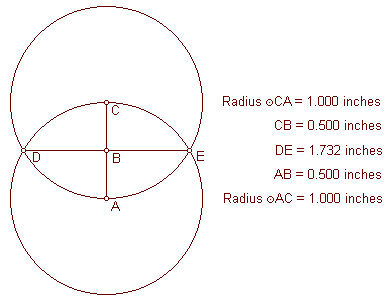
Paul Michell and
Charles Henry have noted the relationship between the
Great Pyramid and the Vesica Pisces.
The small circles in this
diagram are one inch in diameter, and the large circles are three
inches in diameter, forming a small Vesica Pisces
circumscribed by a larger one.
The triangle in this
diagram has the same angular dimensions as the
Great Pyramid. |
 |
|
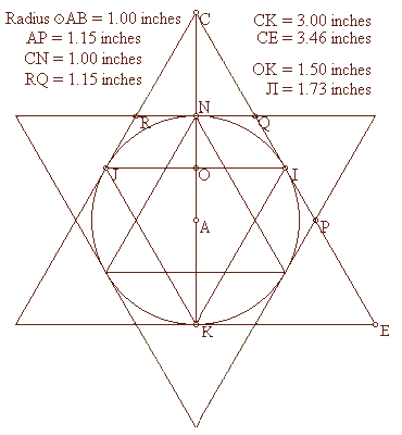 |
The circle in this diagram
also represents the circumference of the Earth with the poles on the
vertical axis.
The radius of the circle
is 1.00 inch.
The exterior and interior
equilateral triangles touch the circle only at the 30th parallels
and the poles.
The height of each
equilateral triangle is 87% of the length of each of it’s sides:
3.00 ÷ 3.46 = .87
1.50 ÷ 1.73 = .87
1.00 ÷ 1.15 = .87
The length of each of the
sides of the interior triangles, including the straight line
distance through the earth at the 30th parallel, is also 87% of the
diameter of the Earth:
1.73 ÷ 2.00 = .87
|
The radius of the Earth is
also 87% of the distance from the center of the Earth to the point
of the exterior triangles’ intersections (AP, AQ, AR, etc.):
1.00 ÷ 1.15 = .87
The Greek foot is thought
to have been developed before the size and shape of the Earth was
known and independently from the foot, which is also thought to have
been developed before the size and shape of the Earth was known. The
foot is 87% of the length of the Greek foot.
The mile, which is thought to have been developed before the size and
shape of the Earth was known, is 87% of the length of the nautical
mile, which was developed specifically in relation to the size of
the Earth. The nautical mile equals one minute of latitude, so 60
nautical miles equals one degree of latitude and 5,400 nautical
miles equals the 90 degrees of latitude between the Equator and the
poles.
The distance from the Equator to the poles is 6,215 miles:
5,400 ÷ 6,215 = .87
One minute of latitude
equals one nautical mile at any longitude.
At the equator, one
minute of longitude also equals one nautical mile, but at higher
latitudes, the distances between each minute of longitude become
shorter. Because the straight line distance through the Earth at the
30th parallel is 87% of the diameter of the Earth, the circumference
around the Earth at the 30th parallel is 87% of the circumference of
the Earth at the Equator, and each minute of longitude at the 30th
parallel is 87% of the distance of each minute of longitude at the
Equator. As a result, just as one nautical mile equals one minute of
longitude at the Equator, one standard mile equals one minute of
longitude at the 30th parallel.
The currently accepted value for the Equatorial diameter of the Earth
is 7,926 miles, with an Equatorial radius of 3,963 miles. The ratio
of the radius of the Earth to the straight line distance through the
Earth at the 30th parallel is 1:1.732.
3,963 miles x 1.732 =
6,864 miles (the straight line distance through the Earth at the
30th parallel).
6,864 miles x pi = 21,564 miles (the circumference of the Earth at the
30th parallel).
21,564 miles ÷ 360 degrees = 59.9 miles (one degree of longitude at
the 30th parallel).
59.9 miles ÷ 60 minutes = .998 miles (one minute of longitude at the
30th parallel).
As an alternative proof,
the currently accepted value for the Equatorial circumference of the
Earth is 24,902 miles, and the circumference of the 30th parallel is
87% of the circumference of the Earth.
24,902 miles x .87 =
21,664 miles (the circumference of the Earth at the 30th
parallel).
21,664 miles ÷ 360 degrees = 60.1 miles (one degree of longitude at
the 30th parallel).
60.1 miles ÷ 60 = 1.00 miles (one minute of longitude at the
30th parallel).
Conclusion: One
minute of longitude equals one mile at (or, like the Great Pyramid,
just below) the 30th parallel.
Back to Contents
PART 5 - ALIGNMENTS OF THE NAZCA LINES & FIGURES
|
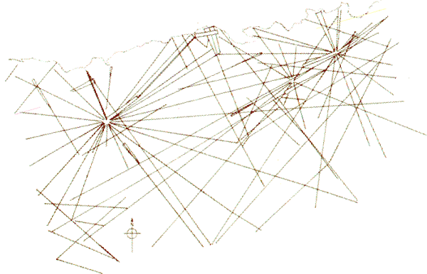
The glyphs and lines
at Nazca are oriented along the line of ancient sites.
This
image of the glyphs at Nazca, with a compass bearing, is available
on the internet, but it is usually oriented away from the cardinal
points so that the figures are roughly horizontal and vertical.
Rotating this image so that the north-south axis is vertical, aligns
the figures and geometric drawings to the line of ancient sites as
it crosses Nazca.
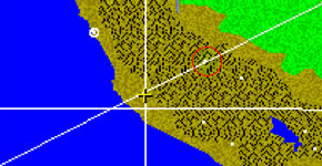
Nazca is
marked by the
yellow cross
on the illustration [above]. The vertical line in the center of the
picture is 75° West Longitude. The horizontal line is 15° South
Latitude.
The white dot in
red circle touching the
north side of the line on the upper right side of the illustration
is
Machupicchu.
|
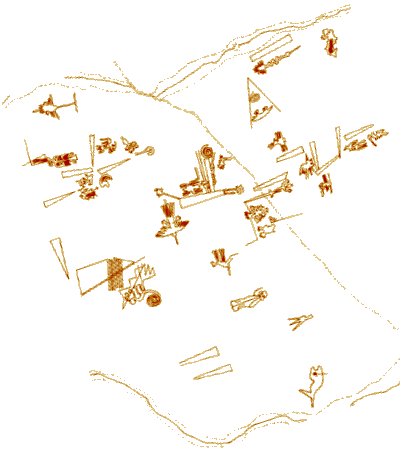 |
This below illustration of
the Nazca lines has also been rotated so that the
north-south axis is vertical, and shows the primary orientation of
the lines is from Southwest to Northeast, along the line of
ancient sites.
Back to Contents
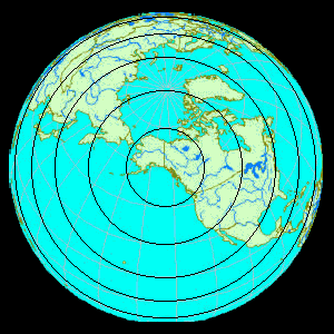
PART 6 - THE AXIS POINTS
Just as every point along the equator is 6,215 miles from both the
North and South Poles, every point along the line of ancient sites
is
6,215 miles from two axis points on Earth. The axis
point in the Northern Hemisphere is near the Southeastern coast of
Alaska, at 59° 42' N 139° 17' W, 25 miles Northeast of
Yakutat, Alaska
The North and South Poles have not always been in their present
locations. Several theories have been offered to explain observed
and suspected movements of the poles in relation to the surface of
the Earth. Plate tectonics, the prevailing theory, suggests gradual
movements of the surface of the Earth. This theory has been called
into question by recent measurements of relative movements of the
earth's surface, and by accumulating seismological data.
Alternative
theories include: Axial shifts; polar wander; and a catastrophic
form of polar wander known as Earth crust displacement.
|
Charles Hapgood
advocated the Earth crust displacement theory in a book entitled
The Path of the Poles. Hapgood supported this theory with
geomagnetic and carbon dated evidence.
In a book entitled When
the Sky Fell, Rose and Rand Flem-Ath also advocate
the Earth crust displacement theory, with additional geological and
archeological evidence. Both of these works conclude that the North Pole was located in the Yukon, at 63° N 135° W,
approximately 80,000 to100,000 years ago.
This is about 250 miles Northeast of the axis point for the line of
ancient sites at 59° 42' N 139° 17' W.
It is interesting to note
that some of the heaviest remaining glaciations in all of North
America is on the Southeastern coast of Alaska, surrounding Yakutat.
If 59° 42' N 139° 17' W
was the location of the
North Pole, then the line of ancient sites would have
been the equator at that time. The concentric circles
in the diagram represent lines of latitude from 59° 42' N 139° 17'
W.
The circle closest to the center of the diagram is 75°N, followed
by 60°N, 45°N, 30°N and 15°N. The line of ancient sites is just
beyond the horizon. |
 |
Since many of the sites along the line are precisely oriented to the
present North and South Poles, it is not suggested that they were
constructed when the poles were in a prior location.
However, if
this line had previously been the equator, the placement of these
sites on this line would be a remarkable coincidence.
In a book entitled Atlantis Blueprint, Rand Flem-Ath and
Colin Wilson
have listed some of these sites, and a number of other sites, in
relation to their calculation of the North Pole in the Yukon,
including sites that would have been on the equator during this
prior polar alignment.
A line around the center of the earth, with
the Yukon Pole as it’s axis point, approaches and crosses over the
line of ancient sites at antipodal points in Peru and Cambodia.
Along the line of ancient sites, the sites in these two areas are
close to being equally distant from the Yukon Pole and from the
Yakutat axis point.
None of the theories offered to explain the motions of the surface of
the Earth, relative to the poles, can pinpoint exact prior polar
positions. The round number coordinates that are used by Hapgood
and the Flem-Aths for the Yukon Pole indicate
that they are approximations.
If the line of ancient sites was
originally selected because of its equatorial relationship with a
prior polar alignment, the most accurate way to determine the
location of the prior alignment is to simply calculate it from the
location of the line of ancient sites.
Back to Contents
PART 7 - THE GREAT PYRAMID, PERU & PYTHAGORAS
The Great Pyramid precisely expresses the 2pi
relationship between the circumference and the radius of the Earth.
-
The height
of the Great Pyramid is 481.4 feet.
-
The perimeter
of the Great Pyramid (the length of all four sides at the base of the
pyramid) is 3,023 feet.
-
The height
of the Great Pyramid times 2pi (6.28) is 3,023 feet.
|
The relationship of the
distances between the Great Pyramid, Nazca, and the axis point
of the line of ancient sites, precisely expresses this same 2pi
relationship.
Inspired by Charles Hapgood's Earth crust displacement theory, Jim Bowles, a retired NASA engineer, wrote
The Gods, Gemini,
and the Great Pyramid. In his book, Bowles provides a
scientific explanation for the causes of Earth crust displacements.
He also discusses many similarities between the lines and figures at
Nazca, the
Great Pyramid
and ancient Egyptian hieroglyphic texts.
Bowles observes that
the Great Pyramid and the Nazca lines and figures would have been
on the equator if the North Pole had been in southeastern
Alaska, and in a lengthy proof using coordinate derivations and
spherical trigonometry he demonstrates the 2pi
relationship between the three sites.
Of course, this 2pi
relationship exists between the Great Pyramid, Nazca and the axis
point for the line of ancient sites, regardless of whether or not
the axis point was once the North Pole.
|
 |
|
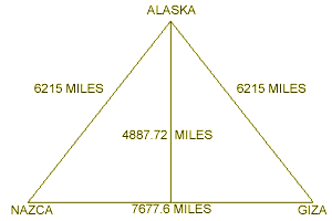 |
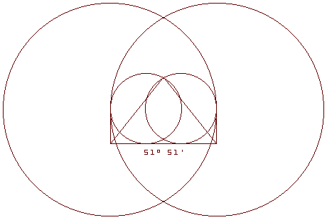
This relationship may also
be demonstrated by diagramming the great circle distances between
the three sites on a flat surface. Along the line of ancient sites,
the distance from the Great Pyramid to the
Nazca lines is 7,677.6 miles.
The distance from the line
of ancient sites to the axis point in southeastern Alaska is 6,215
miles.
This triangle, with a base of 7,677.6 miles and sides of
6,215 miles, forms an isosceles triangle with base angles of 51° 51'
and a height of 4,887.72 miles. The height of the triangle is
calculated using Pythagoras' theory (a˛ + b˛ = c˛).
The height of
the triangle times 2pi equals the base of the triangle times four.
3.1416 x 2 = 6.2832
4,887.72 miles x 6.2832 = 30,710.4 miles
7,677.6 miles x 4 = 30,710.4 miles
|
Another special triangular relationship, found in the dimensions of
the King's Chamber in the Great Pyramid, is the 3-4-5
right triangle that elegantly expresses Pythagoras' theory
(3˛ + 4˛ = 5˛).
In the King's Chamber, the diagonal length of the
east wall is 309", the length of the chamber is 412", and the long
central diagonal is 515". The stone over the entrance to the King's
Chamber is the only stone in the walls that is two courses high.
This stone also expresses a 3-4-5 right triangle relationship by its
measurements of 124"L x 93"H x 155" diagonal.
|
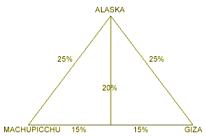
The distances between the
Great Pyramid, Machupicchu, and the axis
point of the line of ancient sites, express this same 3-4-5
relationship.
The distance from the Great Pyramid to Machupicchu
(7,487 miles) is exactly 30.0% of the circumference of the Earth.
The
distance from the Great Pyramid and from Machupicchu to the axis
point for the line of ancient sites is exactly 25% of the
circumference of the Earth.
Dividing this isosceles
triangle by it's height, forms two 15%-20%-25% right triangles. |
 |
Back to Contents
|