|
Chapter Nine
2001: A Mars Odyssey
Within a few days of the release of the new overhead view of
the Face and NASA's "unmasking" of it, the agency began to make
somewhat curious announcements about
revisiting Cydonia.
NASA's Lead
Scientist for Mars Exploration, Dr. Jim Garvin, publicly promised
that not only would more pictures of the Face be taken by MGS, but
that Cydonia and the Face would also be a target of the 2001 Mars
Odyssey spacecraft, due to go into Martian orbit in October, 2001.
This seemed a little strange to us, considering NASA had now
officially decreed the case of the Face "closed;" had gone to great
lengths to debunk the possibility that the Face was artificial, and
that it cost upwards of $400,000 to target any specific feature on
the planet. More images from MGS would certainly be useful, but
getting time on the Odyssey mission to look at Cydonia was an
unexpected boon to our efforts.
Odyssey had the potential to unlock
even more secrets of Cydonia than the Global Surveyor had.
Odyssey carried not only a gamma ray spectrometer, which would be
able to detect the underground hydrogen from any Martian reserves of
ice or water (crucial for a manned Mars mission), it also carried a
combined visual/infrared
high-resolution camera called THEMIS, for
THermal EMission Imaging System.
(Interestingly, in the annals of
Greek mythology, Themis was a Titan, one of an ancient race of gods
whose origins are unknown but who ruled the Earth before the gods of
Olympus. She was the ancient Greek goddess of justice, who was also
the opposite of Nemesis. Where Themis was order, Nemesis was chaos.)
According to Garvin, this unique instrument (which had a spatial
resolution capability about twice that of the original Viking
cameras) would be able to distinguish the "Pyramids of Giza" from
the background noise. It would do this by separating the unique
spectral signature of the materials making up the Pyramids from
their natural surroundings of the Sahara Desert.
The infrared
capability of THEMIS might also allow us to see "below the surface"
of Cydonia for the first time, using the ground-penetrating
capabilities of the near IR wavelengths. Certainly, we felt that if
THEMIS could make out the Giza Pyramids, it could deduce the
mysteries of Cydonia below the sands.
In the meantime, a new Martian controversy had broken out. Back in
June of 2000, NASA announced through Michael Malin and Ken Edgett of
MSSS that it had discovered evidence of water on Mars.
Their
discovery centered around the notion that certain features found at
latitudes above 30° north and south (in other words, from the those
locations poleward, away from the equator) indicated the ejection or
runoff of liquid water very near the surface of Mars. The ejection
points were also curiously facing away from the sun. They proclaimed
themselves to be completely baffled by this finding, since in the
conventional model water almost certainly cannot flow at such high
latitudes and out of the sunlight.
According to the accepted view of
Mars, the planet is so cold that any water should be frozen solid to
a depth of at least six miles. Further, if there was liquid water
near the surface, it should only appear near the equator, where it
is much warmer, and in areas illuminated by the sun's warming rays.
What perplexed them was that these findings were exactly the
opposite of the ideal conditions for water on Mars.
They were also
surprised that the features were so geologically "young." Even
though they admitted that their own model was inadequate to explain
the phenomenon, they put forth an idea that the water was bursting
forth from semi-permeable liquid pockets in crater walls.
Yet they
provided no examples of any mid-latitude, "poleward"-facing
seepages.
Then, just a few days later, the authors shared a discussion about
an image found by Hoagland in the vast image libraries that Malin
had put on the internet. Hoagland was at first perplexed by the odd
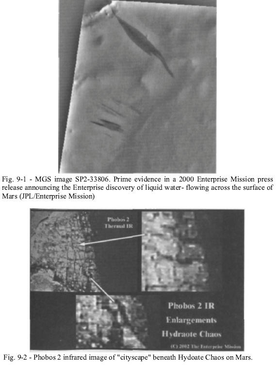
looking streak he had found on MOC image SP2-33806 [Fig. 9-1].
But
in the course of the conversation, Bara was adamant that it was
water. Bara based his reasoning on the visual resemblance to a hose
trickling water out on a dry, dusty slope. The image shows a liquid
seepage that exactly fits the Malin/Edgett model, with liquid
clearly seeping from a dark crack in the crater rim and running down
the slope of the crater wall that faces the direct sunlight. Add to
that the fact this crater sits at about 10° N, which is precisely
the kind of mid-latitude location for their model to work. Note also
that the darkest portion of the flow is in the middle, where the
largest amount of water would be in such a scenario.
But there was one real problem with this model. The water was so
dark, so obviously fresh, that it begged the question of just how
long ago this burst had happened. Water should evaporate rapidly in
the exposed Martian environment. So rapidly in fact, that unless the
water flow causes a destructive action on the crater wall, i.e. a
groove or channel, there should be no real evidence left that the
water was ever there. In this case, there is no such "destructive
force" visible in the flow. It's just a dark, apparently wet patch.
This means that it must have been a very gentle flow, and it must
have happened only hours or even moments before MGS snapped this
image. Not only had we confirmed that there was flowing liquid water
on Mars, we'd caught Mars in the act!
There were, as always, immediate objections to our assertions. The
first was that there was insufficient atmospheric pressure to allow
for liquid water at the surface of Mars, never mind the temperature.
This supposedly guaranteed that any water ice on Mars that melted in
the heat of the day would instantly vaporize.
However, we soon
discovered a paper from Dr. Gil Levin, the principal investigator of
the Labeled Release Experiment on the Viking 1 and 2 Landers. He
cited several sources that confirmed that there were vast areas of
the planet where atmospheric pressure and temperature exceeded the
triple point of liquid water.
The final proof of this came ironically not from Odyssey, but from
the venerable old Mars Global Surveyor. Surveyor has carried an
instrument that up until this point had been pretty much an
afterthought, called the Thermal Emission Spectrometer (TES).
One of
the most stunning (and stunningly ignored) results from this
instrument was its finding that during the summer on Mars (remember,
Mars' year is about twice that of Earth's), the regions of Mars even
above 40° latitude warm to a ground temperature of over 60° F.
Obviously, this is well above the threshold at which water can exist
in a liquid state, and resoundingly destroyed the last objection to
the seeps as liquid water.
We soon discovered that some amateur investigators were interested
in the water seeps as well. Working with them, we found that there
were quite a number of these "seep images." NASA, in the guise of
Malin and Edgett, stepped up to propose that they were "dark dust
streaks," simply the result of a rock becoming dislodged (by wind or
tremors) and tumbling downhill, exposing darker material underneath
the dry surface.
Of course, "darker material" under the ground on
Earth is usually darker because it's wet, but they didn't mention
that in their paper.123
Hoagland then began an exchange of ideas with Effrain Palermo, one
of the brightest of the amateur researchers. Under his mentoring
Palermo had collected an enormous amount of data on the seeps. At
Hoagland's suggestion Palermo and his research partner, Jill
England, then proceeded to systematically map the locations of these
"seep" images relative to Mars surface coordinates, to see if there
was a global pattern to their distribution. As a control, they also
mapped randomly-selected "non-stain" images until a representative
and statistically valid sampling had been completed.
Immediately, two striking global patterns emerged: both pointing to
present day liquid water as a source of the "stains" or seepages. In
the first pattern, the map showed that seepage images appeared
preferentially near equatorial latitudes, mostly between 30° north
and south; none were found above 40° north and south.
This implied
that the phenomenon is restricted to warmer areas of Mars, which
would be expected if these were truly water flows.
An equatorial
pattern is also completely inconsistent with the "dust avalanche"
model put forth by Malin and NASA as an explanation for these
features. After all, winds or tremors that shook the ground loose
would not be restricted to the warmer equatorial regions.
The second, more important pattern discovered was that the water
flows seemed to cluster preferentially around two pronounced
geological features on the Martian surface: the Tharsis and Arabia
mantle uplifts, or "bulges." The curious thing about these bulges,
though, was their location: 180° apart.
It was Hoagland who first realized the significance of this
distribution. "I've got it," he said in a phone conversation between
the authors. "They're anti-podal bulges, Mike. Tidal bulges."
His
conclusion was simple, elegant and indisputable. The Tharsis and
Arabia bulges on Mars were 180° apart, on opposite sides of the
planet. Such bulges are commonly seen all over the solar system, on
Jupiter's moons Io and Europa, on Saturn's moons and even in our own
Earth-Moon system - and they are always, 100% of the time, caused by
tidal forces between two orbiting bodies.
The scars of her former
life as a tidal-locked companion of a mysterious, long-forgotten
parent planet told the story. Mars was not always a planet. It was a
moon. A moon that had once been in a tidally locked relationship
with her parent, just as the Moon was with the Earth.
Immediately, all sorts of implications fell out of this inevitable
conclusion.
In our model, this relationship went on for millions of years,
perhaps hundreds of millions, and was broken only when "Planet V"
(named for the missing planet in Van Flandern's Exploded Planet
Hypothesis) was destroyed in a cataclysmic collision with another
body, or a gargantuan internal explosion. The resultant debris
bombarded not only Mars, but also a large portion of the solar
system.
Mars, as a close-by satellite, was the hardest hit, as the
devastating impacts ripped away most of her atmosphere and blasted
the planet with rubble. It is this bombardment that accounts for the
well known "crustal dichotomy" of Mars, where the southern
hemisphere has a crustal thickness nearly twice that of the northern
lowlands in some places.
And, the stains were indeed pockets of water. They were fossil
remnants of a former Martian bi-modal tidal ocean.
Vallis Marineris,
so inexplicable in conventional terms, became a water-eroded, tidal
bored scar - and the smooth-planed northern hemisphere was further
(and subsequent to the planetary bombardment) massively re-sculpted
in this process, by the sudden and catastrophic release of waters of
the oceans. This newly released "double ocean" flowed north from the
Tharsis Rise and Arabia Terra, completely flooding the northern
lowlands in the process.
Although we tried to get our work published at established Mars
conferences, we were told in no uncertain terms that our theory
would not be allowed to be presented because of our work on Cydonia.
But it didn't really matter, because we now had a completely new
piece of the puzzle. We now knew why it was so imperative for NASA
to keep Cydonia suppressed. It wasn't just that confirmation of
artifacts on another world would cause cultural upsets or even
panic. What was really scary was the answer to the question of what
happened to the civilization that built them.
For such a
technologically advanced civilization to be so utterly devastated
would be terrifying. If Mars was once not so different from Earth,
then the same thing could happen to Earth.
It didn't take long for one prediction after another of our model to
be confirmed. Odyssey's data showed an abundance of hydrogen
(probably water) in the northern and equatorial regions, right where
our model said they should be.
Palermo and England's distribution
pattern was confirmed by work at Brown University, and new outflow
channels were found implying that Valles Marineris had once been
filled with water - and no one had even addressed the anti-podal
tidal bulges of Mars.
Now, however, with Odyssey in orbit, we had more pressing issues to
deal with. It was only a matter of time before infrared images of
Cydonia would start beaming back.
It's Only a "Whole New Mars"- to Them
On January 21, 2002, a story by Leonard David appeared on
Space.com.124
In it, David quoted Steve Saunders, project scientist
for the 2001 Mars Odyssey mission, as saying that the spacecraft was
ready to begin the science phase of its operational life, and that
the Face on Mars would be one of the early "high priority targets."
Obviously, as we said above, if NASA really believed their own
propaganda about what the ground truth of Cydonia was, they wouldn't
be bothering to spend precious Odyssey resources on such an
endeavor.
This heads-up prompted us to consider just what they might be doing
behind the scenes at Mars Odyssey headquarters. Unlike the Mars
Global Surveyor, Michael Malin or JPL would not control the THEMIS
visible light camera directly.
Dr. Philip Christensen, a relative
newcomer to the Mars programs, would run it out of Arizona State
University. This gave us hope that we might actually get some real
data for a change. It was possible that Christensen was one of the
insiders who believed that the public should get the straight scoop
on Cydonia, rather than the part of the group that believed in
continued repression.
For purposes of our own internal discussions, we had taken to
calling these two groups the "Owls" and the "Roosters," two terms
used inside the intelligence community to refer to groups that
advocate suppression of a given issue vs. revelation of a given
issue.
We got the strong impression that the "Roosters" were
winning, as President Bush had replaced Dan Goldin with his own man,
Sean O'Keefe, shortly after the "Unmasking the Face on Mars MOLA
fraud had been exposed. Further, Deep Space told us that the order
to take the May 2001 Face image had come directly from the office of
Vice President Cheney.
We took all this with a grain of salt, of course. We didn't even
know for a fact which side Deep Space was on, much less what the
White House agenda might have been on this issue. Still, things
seemed a bit more hopeful, since some of the previous cast of
characters had been swept aside for this mission.
We strongly suspected it was this change in leadership that had led
to the change in attitude that would make the Face an early target
of the Odyssey suite of instruments, along with the promise of an
"immediate" release of the data.
The more we learned about the THEMIS instrument, the more promising
it looked. THEMIS is actually three instruments in one: a visible
light camera, a thermal imager, and a multi-spectral imager - or
infrared camera. The infrared camera can scan the planet's surface
at 100 MPP resolution, but with a sensitivity of one degree
difference in temperature.
The same infrared instrument, by scanning
in nine different regions of the IR spectrum, would allow
determination of the surface composition of the objects that it
scans at that same 100 meter/pixel resolution.
The total image would
actually be several hundred "pixels" square, allowing us to make
precise comparisons of temperature and material composition
variations over the entire surface area of the Face, at the
resolution of a football field... on a structure over a square mile
in total area. So despite the relative dearth of spatial resolution
from the IR camera, in many ways it would tell us more about Cydonia
and the Face than all of the visible light images taken so far.
As Odyssey approached Mars, the FACETS initiative paid off once
again.
Peter Gersten received a call from the office of Dr. Jim
Garvin, requesting a phone conference with him and Richard Hoagland.
The call was quickly arranged. During the course of the call, Garvin
promised that FACETS would get the data it wanted from Odyssey, and
that a future mission, Mars Reconnaissance Orbiter (MRO), would be
the mission in terms of answering all of our questions about
Cydonia. He also encouraged us to submit papers to the various Mars
conferences and publications, promising that they would get a fair
hearing.
Getting a call from NASA's Mars point man was weird enough. Having
him completely reverse his position and encourage us to participate
in the public scientific process was downright bizarre. Still, we
had little choice but to take the man at his word, and hope for the
best. The climate seemed to be changing for the better.
Then, early in 2002, Hoagland got a call from Deep Space. He told us
that the early returns from the nighttime infrared were stunning,
and had sent shock waves all throughout NASA. He assured us that
Cydonia had already been targeted successfully, and that the data
was described as "amazing." He encouraged us to demand nighttime IR
data, especially of Cydonia.
On February 26, a new story appeared on Space.com by Leonard David,
in which NASA project scientists described the early data from the
science phase of the mission as "amazing" - exactly the word Deep
Space had used. Steven Saunders added that the data represented "a
whole new Mars." While the story was short on details, it was clear
by reading between the lines that the data that was causing such a
stir internally was from the IR camera, and that raised a whole
series of interesting questions.
Some of those, we learned, might be
answered in a press briefing scheduled for the following Friday,
March 1,2002.
As we contemplated what might be revealed at the press briefing, it
occurred to us that we had no reason to think it might involve
Cydonia or the Face, or for that matter even address the question of
artificiality in any meaningful way. But if the data itself was
honest - and given the "new tone" we'd been experiencing, it might
be - then we still had reason to hope that something interesting
would be revealed on the following Friday.
But the important thing
we decided to keep in mind was that the way NASA spun what they
presented was increasingly irrelevant.
What would matter is what the
data showed, not what NASA decided to emphasize politically. Even
after the "unmasking the face" hit pieces and the MOLA fraud, an
MSNBC poll126 had found that among those that had changed their
mind, the vast majority had decided it was more likely the Face was
artificial after viewing the May 2001 image.
Those of us longing for some sort of official "disclosure" on
artificiality or even a radical geologic theory like the tidal model
were missing the point. "Disclosure" is not going to happen with the
president sitting at his desk in the oval office, with the paned
windows and pictures of his family behind him, dourly reassuring us
that it is worth going to work tomorrow despite the stunning
revelations of the "last twenty-four hours."
Disclosure had been
happening all around us, and right in front of us, pretty much
unabated since the magical ball in Times Square turned us all toward
a new millennium. We were being given the data, in bits and pieces,
and pretty much allowed to make up our own minds what we thought of
it.
NASA's own relevancy in the greater scheme of things was
increasingly precarious - perhaps even by design - as it became more
and more obvious to those of us that were paying attention just how
truly wonderful and strange a place Mars, and our solar system,
really was.
It was almost as if someone high up in the agency (or outside it)
was pulling the strings, trying to get this particular rooster to
get its message across without so much as a single crow.
We'd started to get a hint that "something" was coming about two
weeks prior to the late February Space.com piece. A series of images
suddenly appeared on the web, purportedly from Mars and leaked from
a company called IEC. They included color, infrared and radar
imagery of an "Anomaly 502" that was supposed to be of some Martian
ruins just below the surface.
While we immediately had serious
doubts about the legitimacy of the image, this was exactly the sort
of "trial balloon" that a "Brookings" pattern of disclosure would
mandate - put out an image, see what the reaction is, and decide
whether to go ahead with your disclosure based on the response.
So
while we were somewhat unimpressed with the execution, the timing
and content of the release jogged our memories and got us to
thinking.
Why a couple of weeks before the Space.com article and the press
conference? And why emphasize infrared and other ground-penetrating
technologies? Why not just forge a doctored-up surface anomaly? Then
we remembered: Mars Odyssey would not be the first probe from Earth
to use ground-penetrating technologies in Mars orbit.
The Russians had sent two probes, named Phobos 1 and 2, to Mars in
the late 1980s to study the surface and atmospheric properties of
the planet and the composition of one of its two moons (Phobos).
Phobos 1 failed along the way, but Phobos 2 made it all the way to
Mars and operated nominally for a period of several weeks.
Its
disappearance has become the stuff of UFO lore, but in the process
the spacecraft made numerous valuable observations of both the Moon Phobos and Mars.
One of the most curious discoveries was that Phobos' density was found to be extremely anomalous. According to a
paper published in the October 19, 1989 issue of Nature, Phobos had
a bizarre density of 1.95 g/cu.cm ("19.5" anyone?), meaning it was
almost 1/3 hollow. Since both Martian "moons" are actually captured
asteroids, this finding is extraordinary.
There is virtually no way
that a solid object like Phobos can be "hollowed out" in this manner
naturally, leaving a really big question - just who hollowed it out,
and why?
But things got even more interesting when Phobos 2 was rotated to
look at Mars itself. The probe carried an infrared spectrometer, a
device not too different from the infrared thermal imager on Mars
Odyssey. While it lacked the resolution of Odyssey's far better
THEMIS camera, the infrared device on Phobos 2 also gave the Russian
scientists the capability to discern buried objects just below the
surface of the planet (covered with sand or dust) via their relative
rates of cooling.
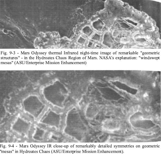
In 1989, just after the loss of Phobos 2, a program appeared on
England's independent Channel 4 revealing the discoveries of the
Phobos 2 probe Among them was a tantalizing infrared image, taken in
the Hydraotes Chaos region (0.9° N, 34.3° W), showing what seemed to
be a fairly mundane landscape in the visible light spectrum - but
when the IR filter was applied to the same area, an astonishing
rectilinear pattern appeared just beneath the sand [Fig. 9-2].
This
regular, highly geometric pattern (across an area the size of Los
Angeles) is strongly indicative of a cityscape just under the
surface. Although some of the rectilinear features seem to be
aligned with the scan lines of the image, others are unmistakably
not aligned, and are also curved and somewhat geometrically
irregular, as they would be if they were wrapping around uneven
topography.
Clearly, they are incredibly similar to some sort of
buried (regular/geometric) construction or tunnel system.
There was no question that a lot of people noticed just how weird
this all was. The program featured comments from Dr. John Becklake
of the London Science Museum (and a very sober guy), and he left no
doubt about what he thought of the images.
Interviewed in front of
an exhibit that was obviously prepared with the help of the Russians
(remember, it was still the Soviet Union then), Becklake was
unequivocal: "The city-like pattern is sixty kilometers wide and
could easily be mistaken for an aerial view of Los Angeles."
The program went on to show excerpts from a Soviet Space Research
Institute press briefing in which the anomalies were discussed. And
yet, all of this high level interest in this story by scientific
heavyweights was virtually ignored in the United States.
So maybe, just maybe, Phobos 2 had given us a preview of what would
be shown in the March 1 press conference. If the infrared images
from Odyssey were in any way similar to what Phobos 2 found, NASA
was going to have a hard time spinning the data.
We had a sneaking suspicion that we were guessing right on this one.
Keeping in mind that NASA is an agency steeped in ritual and bound
by a Brookings-like code of behavior, we couldn't help but notice
one odd little coincidence: The Phobos 2 images of Mars were taken
on March 1, 1989, exactly thirteen years to the day before the
upcoming NASA press conference.
Based on this, we expected that NASA would produce an IR image, most
probably taken of or near Hydroates Chaos at their press conference.
We had only a few days to wait and see if we were right.
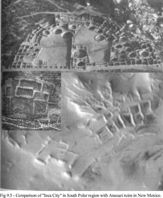
Just as we suspected, we were dead on about NASA's proclivity for
ritual and symbology.
Exactly thirteen years to the day after Phobos
2 had imaged the Hydroates Chaos region of Mars, NASA released a new
series of IR images from Mars Odyssey 2001. The undisputed star of
show was an image of the Hydaspsis Chaos region of Mars. If that
sounds familiar, it should, as it is just a few miles from Hydroates
Chaos (0.9° N x 34.3° W vs. 2° N x 29° W), the location of the
stunning Phobos 2 image.
So, as we expected, we got an IR image of
virtually the same area exactly thirteen years to the day from the
moment Phobos 2 took its picture [Fig. 9-3].
And what a picture. Almost from the beginning, many of the
scientists at the briefing seemed a bit nervous and uncertain. Dr.
Phillip Christensen, especially, seemed edgy as he presented images
from the infrared camera.
As Christensen haltingly displayed the image to the assembled media,
he made no mention of the stunning regularity of the terrain -
especially considering it is dubbed "Chaos."
What was most striking
initially is the incredible consistency of the channels between the
"sand covered mesas" (how does sand stay on top of a flat "mesa"
that is buffeted by 300 MPH winds from time to time?) in the image.
The channels all seemed to be about the same width, and remained
incredibly consistent for miles.
The mesas themselves were
shockingly geometric, not really what one might expect from a
fluvial erosion process - but the Devil of course, is in the
details.
Close-up enhancements showed some very unusual features of these
"mesas" [Fig. 9-4]. There were regular, geometric "notches," or even
openings, in some of them and others showed signs of being buried
foundations for larger objects. A little further up in the image was
a strange looking "crater" plastered on top of a dark rectangle with
incredibly square edges.
Considering that this was not aligned with
the image scan, but is aligned with actual north/south, we were
inclined to doubt this was an image artifact or natural formation.
We were also pleased to get more confirmation of our tidal model at
the press briefing, in the form of Gamma Ray Spectrometer data. The
GRS has a very coarse resolution and wasn't fully deployed yet, but
the GRS team, led by Dr. William Boynton, gathered some data anyway
while the instrument was still in its "parked" position.
Of the data, the most crucial was the information gathered on "high
energy neutrons." These types of neutrons are typically absorbed by
hydrogen - a key component of water and water ice - so by measuring
areas with little or no "HEND" return, it is possible to determine
just if, and how, water was distributed on Mars.
As it turned out, there was a hell of a lot of water, or water ice,
on Mars. Most of it was clustered (as expected) in the south polar
cap, but huge amounts of it are also present on two specific (and
bi-modally opposed) areas of the planet - the Tharsis and Arabia
bulges.
Obviously, this was a flat confirmation of our previous work on the
tidal model. Because of our specific prediction more than six months
previously in our paper, that Odyssey would find exactly this
anomalous (beyond our model) water distribution, we could state
categorically that these findings constitute absolute, inviolable
confirmation that our model is correct.
It also proved that the work
done by Palermo and England is correct, since the water distribution
corresponds precisely where they have found what were now proven
water stain images.
What was stunning was that neither Boynton nor any members of the
assembled press, either because of ignorance or timidity (is there
any American institution that has fallen into a greater state of
disrepair than the Fourth Estate?), made the slightest note of the
fact that the water - inexplicably for the established conventional
models of Mars evolution - was distributed on two such prominent
features of the Martian landscape.
This does not change the fact
that there is nothing in any conventional model that can account for
this distribution. The only explanation that fits the data is our
tidal model.
Even after they had hyped the data to be presented as a "whole new
Mars," and "tremendously exciting," not one of the scientists
bothered to explain just why any of this constituted a "whole new
Mars" - and nobody asked.
This astounding lack of curiosity by the press as to just what made
this data so exciting played right into the NASA strategy we'd come
to expect. NASA's policy was clearly now one of disclosure - but
unacknowledged disclosure. With so few science beat reporters
actually having a science background anymore, they have become
completely dependant on the agency for their material. The
scientists at NASA have become priests, virtually unassailable.
We posted our thoughts on all of this that night on the Enterprise
Mission website. The reaction - from all sides - was swift. In fact,
few stories over the years generated as much negative comment as our
web posting on the new Hydaspsis Chaos IR image.
With unanimity (and predictability), our critics steadfastly ignored
the flat-out confirmation of our Mars tidal model that was included
in the piece, and instead preferred to focus on the infrared image.
During the course of reading through these nasty comments, it became
clear to us that most of these "armchair geologists" not only did
not understand what they were seeing, but also completely
misunderstood (or deliberately misrepresented) just what it was
about this data we found so fascinating.
In many cases, they accused
us of immediately claiming that the geometric block-like features in
the IR image were artificial, which we flatly had not done - to that
point.
For the most part, the attacks focused on our (perceived) inability
to recognize "simple geology." The attackers also criticized us for
not providing a context visible light image of the Hydaspsis Chaos
region in our piece. One web article even blatantly accused us of
being "unscientific" for not including such an image.
Of course,
this critic made no mention of the fact that NASA, at its initial
Odyssey press briefing, also failed to provide such an important
context image.
This, in spite of the fact that the THEMIS folks had
their remarkable nighttime IR image for over a week before the press
conference, not to mention the budget and staff to easily do a
search for such a visible companion image from the Viking archive.
We did not have the luxury of those resources - certainly not in the
few hours immediately after seeing what the THEMIS team presented,
and the posting of our initial article, which we clearly
characterized as a "preliminary assessment" in any case.
We found this reaction, from the alleged "anomalist community" to be
quite disturbing.
They were the ones supposedly most interested in
finding proof of extraterrestrial artifacts, but when we confronted
them with solid evidence, they reacted angrily. We began to wonder
if maybe "Brookings" had been right, that the science and
engineering buffs and professionals would have the hardest time with
"proof of extraterrestrial intelligence.
In any event, when we read through the criticism, it became obvious
that the critics literally had no idea why we found this nighttime
IR image so fascinating, and so potentially important. They assumed
that we were expecting to see blatant evidence of artificiality in
the broader context visible light image. We weren't.
Key to understanding the bizarre nature of this area is the buried
formations - the underlying structure beneath the Martian surface
features, revealed for the first time at this roughly "Viking"
resolution by Odyssey's IR imager.
Just for the sake of argument, let's review one natural geologic
model for this kind of formation for a minute. One of the arguments
consistently advanced to explain such regular patterned formations
is the tired, old, "frost wedging" model.
In typical examples of frost wedging here on earth, the forms are
caused by repetitive freeze and thaw over many years.
The ground
eventually forms cracks, or weak points, sometimes in vaguely
polygonal patterns like you see above. The melting snows find their
way into these fissures, slowly wearing away the ground in between
the harder blocks and creating water-filled channels for runoff.
This is a slow process, and the wedges are very shallow-but the
important thing to remember is that the softer soil is pushed away
by the flowing waters, which eventually shapes the harder stuff into
the polygonal forms we see above. In other words, the runoff flow
creates the shapes. Now let's consider Mars.
In our tidal model, what happened to Mars was quick and cataclysmic.
In a very short period of time, starting with the fateful day of the
destruction of Mars' parent planet, "Planet V," the Red Planet took
a beating almost unparalleled in the history of the solar system.
That first day she lost better than half her atmosphere, experienced
floods of Biblical proportions, was bombarded with literally miles
of Planet V's debris, and lost her ability to sustain higher forms
of life.
Within a few months, if not weeks, virtually all of the remaining
water on Mars was either frozen in place as surface or subsurface
water ice, or sublimated to the poles. So whatever sculpting took
place was rapid and intense. Since frost wedging would have taken
decades to accomplish its erosive process, it seems unlikely that it
can be attributed to what we see here.
Look again at a close-up of this nighttime IR data from Mars Odyssey
[Fig. 9-4].
Remembering that dark is "cool" and bright is "warm,"
this image makes no sense in terms of conventional geologic models.
Casting aside for the moment NASA's silly explanation that the
"mesas" are "dust covered, which is why they are "cooler" in this
image (dust collecting deeply on the tops of flat, windswept mesas,
on a planet where the winds can exceed three hundred miles per
hour), take a good look at the edges of these tantalizingly regular
"cells."
Note that they are all brighter by a factor of at least ten
than the interior of the "mesas" they encircle.
If, in fact, the
walls of these mesas were made of the same stuff as the interior
(rock?), then they would be expected to have pretty close to the
same heat-emissive properties as the interiors, even if there were a
little dust on top. Instead, we see a dramatic difference in the
amount of heat retained by these precisely defined, amazingly
geometric "walls," compared with their very cool interiors. For
conventional geologic models, this is a big problem.
How can a natural ring around a mesa be made of something completely
different than the interior of the mesa itself - since mesas are
carved (in natural geology) out of pre-existing bedrock? And how can
the (shadowed) channels between the mesas now be brighter (warmer)
than the windswept (exposed to wind and sunlight), rocky tops?
The
channels should collect and trap significant amounts of sand and
dust over any interval of time - which should then act as
insulation, producing dark (cold) channels. In fact, the entire
situation is reversed - to NASA's own admitted bafflement.
Enter the Mars tidal model. In our take on this remarkable region,
Hydaspis Chaos was a "dumping ground" for some of the huge volumes
of water that were released from the sudden severing of Mars' prior
gravitational relationship (orbital lock) with Planet V.
As this
catastrophic flood unfolded, the sudden orbital release dumped
trillions of tons of water, massive boulders, dirt, silt and
sediment all over this (and every other) low-lying area on Mars.
The
rushing tidal waves would eventually slow to a trickle, but not
until they left literally trillions of tons of miles-deep debris,
mud and sediment in their destructive wake.
The finest sediment -
initially deposited in catchments between more resistant areas of
rock - would later be worn away by the remaining flows before the
planet then literally froze. After a period of drying, the incessant
Martian winds would then continue to erode - but at a much slower
pace, and for literally millions of ensuing years - what those last
flood waters only started.
Anything standing above ground before this almost inconceivable
cataclysm would have been simply obliterated by the sudden floods.
As these raging waters ebbed, the remaining flows have found their
way to narrower and narrower rivers and streams, constrained
somewhat by the previous geology, eventually carving out the shapes
we see here by removing much of the initial sediments deposited
between the "mesas."
OK, so at this point there's no difference between our model and
conventional processes, right? Well, our model assumes that the area
Odyssey and Viking imaged is covered now with a (relatively
insulating)
"hard mud" to a significant depth (at least several kilometers). The
initial flood of water could not have gone on too long after the
initial cataclysm (because of the sudden loss of atmosphere, and the
freezing temperatures) so there would have been relatively little
post-catastrophe erosion from remaining, flowing water before those
waters froze.
Mud and sediments unlike exposed bedrock, do not
retain heat, so it would be expected (in this model) that these deep
sediments would now show up in any nighttime IR image as a "dark" or
"cool" area, just as we see here over most of the nighttime IR image
- but if simple geologic theory were not enough, there is further
proof in this same image that we are looking at a huge "mud flow,"
rather than exposed planetary rock.
Just above the "mesas" in this nighttime image (to the west, since
north is to the right) are two modest impact craters, each a couple
of hundred feet across. In both cases, in the infrared they have
brighter (warmer) rims than their surroundings, and dark (cool)
interiors. This is as it should be - if the crater rims are (warmer)
exposed outcrops of underlying bedrock, uplifted by the initial
impact process, and the bowl-shaped interiors have trapped (cooler)
blowing dust and sediments, which now appear dark because of their
thermal insulating properties.
Yet something's not quite right with this standard geological
picture.
If you compare the brightness of the crater rims (the
"exposed rock" in the impact model), they are only slightly brighter
than their surroundings.
They are certainly not as brilliant as the
(presumed) exposed mesa rock walls of the Chaos region just to the
east. It's as if the craters were created, not in bedrock, but in an
ancient layer of insulating mud. If the impacting objects had struck
a hard-pan surface, presumably the underlying rock would have been
shattered and raised, exposing it as brightly as the edges of the
nearby eroded "mesas" - but it has not.
The IR signature of each
crater rim seems curiously dull - as if the thermal emission was
coming from something with a much softer, far more insulating nature
than bare rock (which is exactly what these nighttime IR images are
supposed to reveal). It in fact appears like clods of friable (and
thus insulating) sediment instead of deeply excavated (by the
cratering process) bedrock.
Thus, these completely unexpected IR crater signatures neatly
reinforce our model - that this region is in fact a deep flood plain
of overlying mud and sediments, with the ancient bedrock now buried
miles below the surface.
So these simple craters reveal remarkable, independent confirmation
for our basic massive flood scenario. These cannot be simple
exposed, rocky mesas, now covered with accumulated windblown dust,
but rather, that this whole area (and the other "Chaos" regions?) is
one massive mud flow from the ancient cataclysm that rent Mars from
its mother planet about sixty-five million years ago from its orbit
of Planet V.
If this area is indeed covered to some depth in ancient sediments,
then the simplest reason the interior of the mesas are now dark is
not because they are composed of the same material as the much
hotter walls and are covered with dust on top, but because they are
literally catch basins filled in with those same ancient muds still
contained within the current IR bright walls.
The latter, then, are simply composed of some much more
heat-retentive material arrayed in a stunningly regular, geometric
pattern of amazingly uniform thickness - and stretching for
literally hundreds of collective miles around each mesa.
Thus, these Hydaspsis Chaos mesas do not appear themselves to have
been shaped and eroded by the vast tidal floods gauging out
pre-existing bedrock into intricate geometric forms, but by the
tidally-released sediments flowing around and over pre-existing sets
of resistant walls composed of a heat-retentive something, walls
clearly now already in place before the catastrophe itself.
So then, the next question must become: What kind of natural
geologic process forms such walls - with regular, uniform thickness
and intricate (and opposing) geometric patterns - that can be filled
in by massive mud flows of the type we now see here? The short
answer is: none.
There is, however, a perfectly viable alternative scenario. Let's
consider what would happen on a planet like ours if a sudden
cataclysm on the scale of what happened to Mars were to occur.
If the Earth's rotational axis suddenly shifted, or if the collapse
of the Ross Ice Shelf resulted in massive amounts of water suddenly
inundating habitable coastal areas, everything above ground would be
swept away almost instantly in the resulting massive floods. Large
buildings would be crushed and tossed aside, leaving only their
foundations below the ground.
If this happened in an area the size
of say, the Los Angeles basin, then, all one would expect to see
would be the remnants of these former rising structures, arranged in
a hauntingly geometric pattern indicated by their remnant
foundations.
If you then flooded that whole area with miles-deep sediment, the
hollowed-out cores of these former skyscrapers and other structures
would also fill with sediments - and the whole L.A. basin would
become one big featureless sea of mud.
On Earth, however, as rain and wind began to erode away these
newly-formed deposits, eventually the eroding sediments would sink
low enough to reveal the preserved foundations of the former
artificial structures. At this point, the waters (and wind) would
take the path of least resistance, as they always do, and flow
around the massive base foundations of these former structures.
Yet,
protected from this erosive action by the basement walls, the
interior sediments would remain where they were initially trapped in
order to dry, and form a series of essentially level "mesas" to any
aerial observers, separated by the former streets between the
buildings.
Thus, our hypothetical post-cataclysm L.A. basin would strikingly
resemble (in the infrared) exactly what we were seeing in this
nighttime Odyssey Mars image (though on a much smaller scale) - even
down to the geometric crenellations on the mesa walls.
It was increasingly apparent that these bright, intensely geometric
outlines are, in fact, the exhumed foundations of former massive
artificial structures - all that remains after the ancient raging
floods completely leveled the original structures' towering upper
levels.
So what we'd found in the Odyssey infrared of Hydaspsis Chaos are
the ancient foundations of something far more crucial to our
eventual understanding of this entire shattered planet, far more
relevant to the search for who we ultimately are, than mere frost
wedging.
It is precisely these remarkable structures, if not answers, that
NASA was obviously looking for when they took and then released this
specific Odyssey IR data as their "first nighttime image," precisely
thirteen years to the day after the Russians took their own
provocative Phobos 2 IR images just a stone's throw away from this
same area.
Is it truly an accident that this first IR image - from a
mission named literally after Arthur C. Clarke's famed epic of
extraterrestrial intelligence's formative involvement with mankind -
should be a set of buried artificial structures which (if we had now
read the Odyssey IR correctly) can teach us so much about Cydonia
itself, if not the history of Mars destruction.
The last nail holding in place this increasingly tattered assertion,
that these intricate, highly ordered Hydaspsis Chaos forms are
somehow the product of a "simple Martian geology" was then removed
not by us, but by NASA itself.
At two subsequent Mars Odyssey public lectures, one held at JPL's
Von Karmen Auditorium, the second at Pasadena City College (in Room
333, of course), Dr. Roger Gibbs, the new Odyssey Project Manager,
provocatively showed this same baffling IR Odyssey image, and flatly
admitted that he and the entire Odyssey team had "no idea how to
interpret it."
"Why does a channel have no dust, and the top of a mesa does?" he
asked rhetorically. He then asserted that the working model was that
the channels had somehow "collapsed around the mesas."
Again, this is silly. Clearly the exposed channels were literally
scooped out by an erosive process that attacked the softer, drying
mud, but left the hard, geometric foundations - each containing its
own reservoir of trapped sediments - of the ancient arcologies
essentially intact.
Somehow, Gibbs and his colleagues can't publicly consider a
non-natural explanation for these impossible features, even while
blandly admitting,
"It [the IR image] really asks more questions
than it answers."
Clearly, if the explanation for Hydaspsis Chaos
was "simple geology," as our critics had asserted, it seems to be
"geology" well beyond the leadership of the Odyssey Mars mission, if
not of NASA's best planetary minds.
Yet still we had one last hurdle to clear. Some of the critics then
raised the similarity to even older and similar geologic anomalies
on Mars, like Mariner 9's so-called "Inca City." They pointedly used
the MGS
images of "Inca City"
in an attempt to dismiss Hydaspsis
Chaos as an obviously similar "natural set" of features - but there
is very little natural about the "Inca City" at all.
As you can see, "Inca City" (Fig. 9-5) compares very favorably (in
terms of straight geometry) to well-known archeological ruins on
Earth, like the Anasazi structures in Chaco Canyon.
Even though Inca
City is on a much larger scale and completely unexcavated, this does
not mean that artificiality should be ruled out a priori - certainly
not based simply on existing visible light data. To expect ancient,
highly eroded archaeological "ruins" on another planet (and ones of
potentially immense scale) to look as clean as a recently excavated
dig on Earth is not only naive in the extreme, it's not even
logical.
As noted previously, an IR study of this formation is crucial to
determining the underlying structure that (even heavily "mantled")
presents such a compelling geometric comparison to our own
terrestrial monuments. It's bad enough to dismiss the sand and
frost-covered "Inca City" as "natural" without a closer study of the
entire area, but to then cite it as some sort of "proof that the
Hydaspsis Chaos images have a similar "natural" explanation, is
almost criminally idiotic.
After all, what lies just beneath the surface sometimes tells a
completely different story.
Do Geologists Dream of Windblown Sheep?
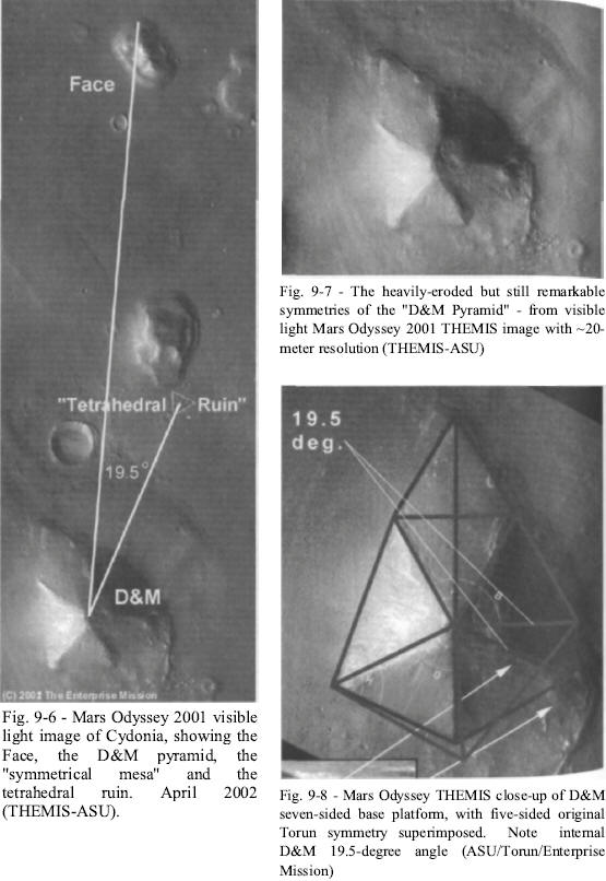
After another month of waiting, on Friday, April 12, 2002, we got
the first Mars Odyssey data to cover the Cydonia region of Mars.
Unfortunately, we did not get what we had hoped for (a
multi-spectral nighttime infrared image of the Face and surrounding
structures). Nor did we get a full-color image of the Cydonia
complex in the promised five-band color. What we did get was a nice
grayscale strip from the spacecraft's visible light camera [Fig.
9-6].
At nineteen meters-per-pixel, the image was substantially
better resolution than the fifty meter-per-pixel images we got in
the Viking era. Still, it is an order of magnitude lower than the
four to five meter-per-pixel images we got in the best of
circumstances from Mars Global Surveyor.
This did not prevent it from being useful. It was still a better
overhead view of the center of the Cydonia complex than we had
before, allowing us to view the specific objects of interest in
context and at a resolution we have not generally seen (the D&M, for
instance, had been almost completely missed in the publicly released
images from Malin Space Science Systems).
Previously identified
objects of interest that were visible in the new Odyssey image strip
included the Face, the D&M Pyramid, the Fort... and some surprises.
The first thing we noticed was that the so-called "massive
tetrahedral ruin" adjacent to the symmetrical mesa just south of the
Face was much more clearly defined than in the previous images. This
object was first spotted on the infamous Catbox MGS image strip. It
had been stylistically interpreted from previous images as a
"dolphin," or various other absurd pictogram shapes, with one
amateur pixologist even claiming he saw a "trailer park" at the base
of the object.
Part of the illusion was the extreme forced
perspective of that original MGS image-taken 45° off-nadir - which
effectively distorted the shape of the ruined pyramid. We could now
see clearly from directly overhead that there were two distinct
faceted walls that once made up this tetrahedral structure.
The
object lies just south of the suspiciously symmetrical mesa and -
conveniently - lies at exactly 19.5° off the base symmetry axis of
the D&M. This same axis passes right between the eyes of the Face.
The real prize, however, was the good, higher-resolution image of
the D&M, which we could now compare with the Viking data.
One of the most controversial objects in the entire Cydonia
artificiality debate (because of its status as the lynchpin of the
Hoagland/Torun Geometric Relationship Model), the D&M had always
been key to deciphering the correctness of the original Cydonia
observations from two decades ago.
The most crucial question
surrounding the D&M has been that of the Pyramid's five-sided
symmetry, which was suggested strongly by the original Viking data
and was an issue of some considerable debate in years past. Vince Dipietro, for one, had maintained for years that the D&M was only a
four-sided object, objecting to the implication of a "fifth
buttress" in the shadowed side of the Pyramid on the Viking data.
This projected five-sided symmetry not only held up extremely well
in the new image [Fig. 9-7] (note especially the four clearly
defined faceted sides to the pentagonal pyramid meeting at a central
apex - exactly as observed by Hoagland and Torun on the original
Viking data in 1989), but we could now see substantially more detail
on the lower section of the damaged right hand side.
We also
(despite deep shadow) could verify the existence of a "fifth
buttress" to the northeast - the final piece needed to complete the
pentagonal form and reconstruct the object's original, undamaged
shape. The buttress seemed to be pretty much the same length as the
other visible buttresses (the southeastern buttress is mostly buried
under debris flow from the mild collapse the object has endured) and
verified the predicted geometric form proposed by Torun in 1988
perfectly.
Obviously, such a "hit" was way beyond even "the power of
randomness," and is a compelling confirmation of the validity of
Torun's original work.
We could also see additional evidence of the internal bulge in the
Pyramid as noted back in the original investigation. It was once
argued - by Hoagland in Monuments - that the "crater" to the right
of the Pyramid seemed to be some sort of "entrance wound" for a
possible projectile that may have accounted for the bulge in the
upper right hand quintile.
This new Odyssey image gave far greater
detail of this area, and it seems to substantiate earlier 3D shape-from-shading work done by Mark Carlotto that indicated it
might actually be a horizontal "entrance point," either from a
projectile or as an actual architectural entrance. Additionally, the
new image - at nineteen meters per pixel resolution - revealed new
structural details of both southern "buttresses" that further
reinforce the idea that these are essential architectural elements
of a massive artificial edifice.
The conventional geologic model of these features is that they are
due to "slumping."
Basically, the idea is that loose material from
the top of the D&M tumbles down the slopes of the Pyramid and
preferentially piles up at the corners of the object. Forgetting for
a moment that none of these geologic experts seem to have noticed
that the mass-wasting has put piles of debris precisely at the five
corners of a 1.5 mile high, bilaterally symmetric, pentagonal
Pyramid, our model is that these are actually reinforcing
"buttresses" that have a specific architectural and mathematical
function.
Close examination of the new image - remember, twice as
good as the Viking data - shows that these buttresses are indeed
just that. They have a very "boxy," geometric look - and the
southwest buttress even seems to have two rectangular openings
(doors?) in the base. The simple truth is that no "mass-wasting"
process produces rectangular box shapes - certainly not ones with
several-hundred-foot-wide doors in them.
The other major discovery from the new image was that the entire
structure could now be seen to be placed atop a huge rise (or
platform) much like the Giza Plateau on Earth - and this newly
discovered platform, which was not resolvable in the Viking data,
seemed to have a geometry all its own.
When you rotate the image of the D&M from the way we are all used to
looking at it, we can see that there are two distinct but partially
buried edges to the plateau that the D&M rests on. These two edges,
not visible in the original Viking data, meet in an apex point that
is exactly aligned with the SE buttress on the opposite side of the
structure [Fig. 9-7].
What this new perspective on the D&M now allows us to see for the
first time is that the pyramid rests on a 2D, seven-sided platform
(or base) upon which the massive 3D five-side "Rosetta Stone"
structure was constructed. It also revealed an additional, second
alternative line of symmetry for the object, which conversely
produced a second, bi-laterally symmetrical four-sided geometric
figure.
When these two shapes (the seven-sided platform and the five-sided
pyramid) were superimposed upon each other, they once again
reinforced the quintessentially tetrahedral message of Cydonia [Fig.
9-8]. Indeed, one of the new internal angles generated by the new
figure is none other than the ubiquitous 19.5°. Not only did this
new data flatly validate the original Torun reconstruction and
analysis of this enigmatic object, but it also demonstrated the
correctness of the geometric relationship model derived from it (as
if the numerous successful predictions of the hyperdimensional
physics model hadn't already done so).
The new image also allowed us to do an actual side-by-side-by-side
comparison of the Face from Viking, MGS and Odyssey. Immediately,
several things became obvious.
First, the Odyssey image confirmed
that the MGS April 2001 image had been poorly ortho-rectified, as
the Face platform was much narrower (from Odyssey's more direct
overhead perspective) than it was on the Surveyor image.
Also, the
"nostrils" from the Catbox image had returned after being nearly
invisible on the April image, and the "lion"-side eye-socket
appeared to be better aligned with the opposite socket.
Of course, none of this prevented the usual nay-saying from NASA.
While almost all images released of anything other than Cydonia are
not accompanied by captions or headline stories, images of the Face
and Cydonia invariably are.
This image was no exception. The
caption, posted on the Arizona State University THEMIS web page, was
a laughable mish-mash of airy homily, inappropriate comparisons and
scientific contortions that seemed way too anxious to describe the
indescribable in terms that make sense to the limited minds of the
geologists, who were trying to close this issue once and for all. It
began by declaring that "nature is an imaginative artist" and then
proceeded to inform readers that we are always seeing things we have
"dreamed up" in our imaginations.
They then compare the Face to
Arizona's Camelback Mountain (shades of NASA's previously failed
"Middle Butte Mesa" comparison), and "Sleeping Beauty" near Ludlow,
California, among several other places. They naturally fail to
mention that all of these locations only take on the visages they
are famous for as profiles from the ground.
This is, as has been
pointed out to the NASA regulars on many occasions before,
completely unlike the Face, which is designed to be seen from
overhead. And, as is par for the course with these kind of
assessments from the "scientific community," they tried to deal with
the Face in isolation, completely ignoring the preponderance of very
anomalous structures scattered all over the rest of the image - like
the bi-laterally symmetrical, pentagonal D&M Pyramid.
They finally attempted - not very well - to claim that the Face's
appearance is the result of wind-based erosion, or a combination of
Aeolian processes and a bizarre "pasting" process that they didn't
even attempt to explain thoroughly. This is just a variation of a
discarded "differential erosion" argument that NASA had floated
several years before.
This recently rediscovered notion is frankly
nothing more than the authors' substantially uninformed (or
deliberately obtuse) opinion, which seems to permeate all levels of
NASA and its affiliate academic institutions, and not only ignores
the substantial history of predictions and observations of various
independent researchers, but simply does not hold up under the most
elementary critical scrutiny.
They fail to note the incredible
variety of "mesas" in the Cydonia region.
-
How exactly did the
Martian wind decide to change directions, at very precise 85.39 and
69.49 angles, just around the apex of the D&M every few thousand
years to sculpt the precisely mathematical Cydonia Rosetta Stone and
Pentagonal D&M shape?
-
Or perhaps the wind only blew a few miles to
the north, where it "sculpted" the Face out of our dreams?
-
Perhaps
some completely different process was responsible for forming the
D&M only a stone's throw away?
Now we're willing to engage in an
exchange of opinions, but for these "experts" to couch theirs in the
guise of stipulated fact is not "science," any more than any other
sweeping and unsupported assertion would be.
The reality is that if the Face and the rest of Cydonia were
artificial, then geologists, of all people, would probably be the
last group on the planet to recognize or acknowledge it.
The reasons for this are myriad and complex, but revolve chiefly
around the major problem confronting modern scientific archaeology.
Initially, from mere appearance, archeologists and geologists can't
even agree on whether a fairly obvious Earth artifact is artificial
or derived from a completely natural process. It is therefore hardly
surprising that a potential artifact on another world has been a
source of intense, continuing debate for decades.
A case in point is the set of recently-discovered pyramids below the
Pacific Ocean just off Japan, on
a submerged undersea island called Yonaguni.
Archeologists were quick to point out the various
characteristics that identified these structures as artificial,
monumental architecture. Geologists countered with a series of
equally reasoned arguments based on the biases of their science -
that natural processes could explain all these data points just as
readily. To most observers, the winning argument was made patently
obvious simply by looking at the pictures.
The underwater pyramids
were blatantly artificial. Yet the debate has raged on for years.
It was only when a team of divers sent by the Discovery Channel
discovered a stunning, underwater Face, complete with a Mesoamerican
headdress (or lion's mane?), that some of the geologists relented.
These new finds, joined with some key observations by Japanese
marine geologists, finally broke the dam and forced the admission of
the obvious - somebody built the stuff.
But even this single,
redundant, unifying theme - faces amid the ruins, both here and on
Mars - can leave some geologists searching for some remotely
plausible natural explanation.
This sort of debate is exactly why we have always argued that
planetary geologists are not well equipped to solely evaluate
Cydonia - or any other putative artificial structures on the planet
Mars. If the Face and other objects there are artificial, then they
should be looked at first and foremost thru the lens of archaeology,
and geology only secondly (for their natural context) - if at all.
Geologists tend to look at everything as the product of one of their
familiar natural processes, since their training has told them (a
planet full of artifacts on Earth notwithstanding) that this is the
process by which everything in the solar system has been formed.
This is how you get the simplistic "sand dunes" argument when
geologists are confronted by anomalies like the Glass Tunnels of
Mars.
The simple fact is that when dealing with a problem outside
their own discipline, and therefore limited expertise, most
scientists - from whatever field - will resort to any familiar
explanation from that field, and then cling to it at all costs, no
matter how silly or ultimately contradictory it turns out to be.
This is what their training has taught them to do (go for the
familiar first). It is also what their training limits them to.
This is why the Brookings Report was so concerned with the impact
that the discovery of artifacts might have on scientists of all
stripes.
Still, despite the limitations imposed on the image by the ASU
geology department, there were some genuine geologic observations to
be gleaned from the new image. For instance, there was some evidence
of wind erosion at Cydonia, including a predominant "wind
direction."
There is a clearly predominant "wind direction" at Cydonia. We could
see from the earlier close-ups of the Face that the city side (and
the city side only), showed some evidence of minor pitting as the
result of wind erosion processes.
But the Cliff side was clearly
protected from this process - it showed
no sign of pitting - and quite obviously the minor wind erosion we
observe was not a significant factor in the overall shape of the
Face, this last observation meaning it was either very light
(unlikely on a planet with occasional gusts for several weeks in the
300 mph range) or very recent.
The new image of the D&M only
confirms this single predominant wind direction.
The three fully
exposed buttresses are the ones that are most exposed to these
presumed "winds of Cydonia." This is because this wind has simply
blown away the dust and sand that might have once covered the
structure. The two partially buried buttresses are on the opposite
side of the structure, away from the howling winds of the Cydonia
plain and presumably protected by the towering structure itself.
From these simple observations we can easily deduce that which seems
to elude the best minds that NASA can throw at the "Cydonia
problem." Wind was not a significant factor in the geomorphology of
either the Face or the D&M. To ascribe the shape of any object of
interest at Cydonia to this process flatly ignores the observations
that contradict it.
It would be easy, even comforting, to dismiss this as merely
rationalization - to assume that the staff geologists at ASU, so
used to explaining things in comfortable terms, had simply chosen to
ignore the frightening paradigm shift that the Face, the D&M and
other objects represent.
To somehow convince themselves that, yes,
the wind could make those turns...
Chapter Nine Images
Back to Contents
|