|
...continuation of "Mars Reconnaissance
Orbiter and "The Lost Cities of Barsoom""
Again, sunlight is coming from the right.

For those with minimal experience in
aerial archaeology -- let alone, a background in analyzing ruins on
another planet via satellite (!) -- it may be a bit difficult to see
some of the more subtle features in these images ... to say nothing
of coming to grips with the inherent unbelievably ... after all
the NASA propaganda ... of viewing actual ancient ruins on the
planet Mars!
What’s needed is a solid scientific basis for comparison.
That comparison (another example, below) -- acquired as a set of
1930’s aerial photographs over a similar desiccated landscape here
on Earth -- presents a standard archaeological example of another
partially-buried terrestrial ruin in Iran, for which there is NO
SCIENTIFIC DOUBT as to it’s "artificiality" ... to be compared
directly to what we’ve found on Mars.
Note the astonishing scientific similarity ....
In terms of recognizing the hallmarks of "intelligence" via such
"remote sensing" technology, the rules are simple: look for the
geometry ... repeating, rectangular geometry ... and, features
arrayed in straight lines (especially those straight line features
simultaneously arrayed at right angles to each other ...).
Discovery of such repeating "Euclidian geometry," above a certain
scale ... on ANY planet ... is THE major, essentially fool-proof
signature... that intelligence "was there" ....

Or, as the late Carl Sagan noted so
succinctly in "Cosmos" many years ago ....
"The first indication of intelligent
life on Earth lies in the geometric regularity of its
constructions ...."

This is, by no means, an "exhaustive"
listing or analysis of the areas -- or the number -- of "anomalous
geometric artifacts" present in just this first MRO HiRISE "test"
image! For a more comprehensive survey (and, with thumbnails ...) --
carried out independently by another researcher, also a member of
the Enterprise Conference Team -- go here:
http://www.mroimages.com/
There -- organized by category and location on this 30.9 by 11.7
mile HiRISE 190.5 Megabyte image -- is a far more complete survey of
the "wonders" to be found in just this one small region ....
Mars Reconnaissance Orbiter.
Is it any "wonder" now that many have begun to question seriously
... exactly "why" and "for whom" ... is this (already astonishing)
"reconnaissance of Mars" REALLY being carried out ..!?
So, where does this leave us?
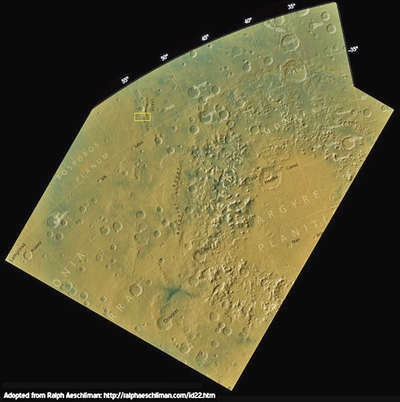
With Mars Reconnaissance Orbiter’s first released image mosaic --
centered just northwest of the great "Argyre Impact Basin"...

...straddling an ancient river channel
called "Ogygis
Rupes" (below) -- we not only have more than ample new
confirmation of intelligently-designed artifacts on Mars ... we see
these latest examples spread across a very large area on Mars,
encompassing at least several hundred square miles (!) -- indicative
of another, one-time city-sized complex ... suddenly destroyed by
some immense catastrophe ... only to be excavated once again by the
inexorable forces of entropy and Time.....

Besides countless earlier examples of
equally astonishing "half-buried artificial structures on the Red
Planet," captured by every previous NASA unmanned spacecraft -- such
as this remarkable find (below, right), imaged by Mars Global
Surveyor a few years ago ... of
another striking, obviously
sand-covered artificial ruin on Mars, located at 28.38° N., 332.54°
W., in a region called (appropriately) "Arabia Terra"...

...we also find a more clandestine record
of completely independent but strikingly similar Soviet confirmation
of "ET Martian ruins."
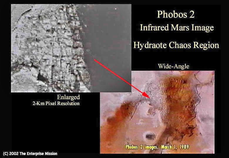
The prime example of Soviet contributions in this area came with the
ill-fated Phobos 2 Mars Mission, in 1989.
Phobos 2 -- before it was
mysteriously "lost" (after only 90 days in
Mars orbit) --
transmitted striking infrared images (below) of
additional, highly geometric, also half-buried Martian features...
eerily similar (but in a totally different region -- Hydroates Chaos
...) to our latest "buried Martian city" (northwest of the Argyre
Impact Basin).

In 2002, when NASA’s Mars Odyssey
Mission released its
first nighttime IR "test" images -- exactly 13
years (to the day!) after Phobos 2 acquired its own anomalous IR of
its "buried Martian city" -- the Odyssey data
also revealed an
astonishing set of incredibly geometric, half-buried Martian
landforms ... in a region "right next door" to the
Soviet Phobos 2
images -- in "Hydaspsis Chaos" (2° North/ 29° West -- below).

Although NASA/JPL tried to pass these
astonishing, clearly artificial structures off as merely typical
"Martian mesas," the undeniable, incredibly redundant geometric
nature of the objects (both inside and out -- note the "double,
triple, and even quadruple, parallel walls!"), and their obvious,
carefully designed architectural layout in relation to each other
... argued compellingly for a totally different scenario ....

A comparison with a partially-buried
ruin in Iran (below, left) reveals an astonishing similarity between
this Earthly, man-made structure ... with it’s periodic "walled
fortifications" -- and its vastly larger, but identically "walled"
counterparts ... on Mars!

But -- is NASA the only space agency to
have acquired solid evidence, from a variety of missions and their
instruments, of "buried Martian cities" ...?
In 1999, well after the "collapse" of the old Soviet Union, the lead
Russian designer of unmanned spacecraft bound for Mars and Venus
(including Phobos 2) -- V.G. Perminov -- in collaboration with
NASA Headquarters’s own History Office, in Washington D.C. -- had
translated a very personal (if all-too-brief) memoir of the Soviet’s
many attempts to send "his" spacecraft to the Red Planet ... titled:
"
The Difficult Road to Mars: A Brief
History of Mars Exploration in the Soviet Union"

Provocatively, in his own Introduction
to "Difficult Road ..." Perminov makes some eerily "predictive"
comments ....
"... The first stage of Mars
exploration is finished. Surprisingly, vegetation, canals, and
traces of intelligent life have not been found. However,
dried-up courses of waterways have been observed. What happened?
Why did water disappear? Did primitive or intelligent life exist
in the past, or does it exist now on Mars?
"Today, we cannot answer these questions. It now seems like Mars
is a lifeless desert. On the other hand, we know that in Earth’s
deserts, archeologists dig up cities that flourished in the past
but were neglected by ancient people, and they are now covered
with sand.
"In 1971, the largest dust storm ever registered by astronomers
covered the whole Martian surface. For a few months, hundreds of
millions of tons of dust were suspended in the Martian
atmosphere. As a result, one could not observe the Martian
surface. Nevertheless, one cannot rule out that cities covered
by sand may exist in the Martian deserts. That would be evidence
of an ancient Martian civilization that disappeared or moved to
other planets [emphasis added] ...."

Question: Was Perminov merely
"speculating" re what he’d hoped to find on Mars ....
or... was he, in fact, subtly revealing what the Soviet’s had already --
and also secretly -- confirmed ... ?... "The Lost Cities of Barsoom!!"
And then published in, of all places... an official NASA/Russian monograph -- detailing the star-crossed
history of repeated Soviet efforts to reach Mars ... if not the
reason why?!
Stay tuned ....
Update --
4/6/06
The first HiRISE engineering "test color strip" of Mars -- acquired
March 24th just prior to the beginning of MRO’s next six months of
aerobraking into its final "science orbit"-- has now been released
by the HiRISE Team at
the University of Arizona,
JPL and
NASA
(below).
A full-scale Tiff (uncompressed -- 85 Meg!) version of this same
image, for detailed study and enlargement, is also available at
NASA’s "Planetary Photojournal."

The new image is of a restricted,
central section of the original B&W, full engineering MRO mosaic
(below) -- the latter released to the media and general public by
NASA March 24th.

The new image was created by the
acquisition of multi-spectral infrared and blue-green color data,
combined with the originally released red filtered mosaic (in B&W --
above) -- detected over the central section of the larger image via
three sets of specifically "filtered CCD picture element detectors."
When these three separate, overlapping
images are recombined through appropriate filters, the result is a
full-color "central color strip" -- inset into the larger "red
filter" (presented in B&W) mosaic ... (below).

This image is NOT "natural color" (as
the human eye would see Mars, looking down from orbit), but is a
"false color view" ... shifted towards the infrared. It is designed
to detect subtle surface mineral and composition differences,
revealed as different color shadings.
When the final Mars Reconnaissance Orbiter Science Orbit is achieved
(sometime in September/October), another high-powered instrument
on-board -- the
Compact Reconnaissance Imaging Spectrometer for Mars
(CRISM) -- would be able to map the same features (imaged here --
above) in 544 much narrower-spectrum "colors" (!) -- allowing unique
mineral identification of the composition of the curiously "colored"
patches seen in this false-color HIRISE view.
The spatial resolution of CRISM at that point will be ~18
meters-per-pixel (~60 feet) -- about the size of a small house! --
compared to the ~8-foot-per-pixel resolution of the present color
HiRISE image (in its intended final orbit, the pixel resolution of HIRISE will be about "11 inches per pixel").
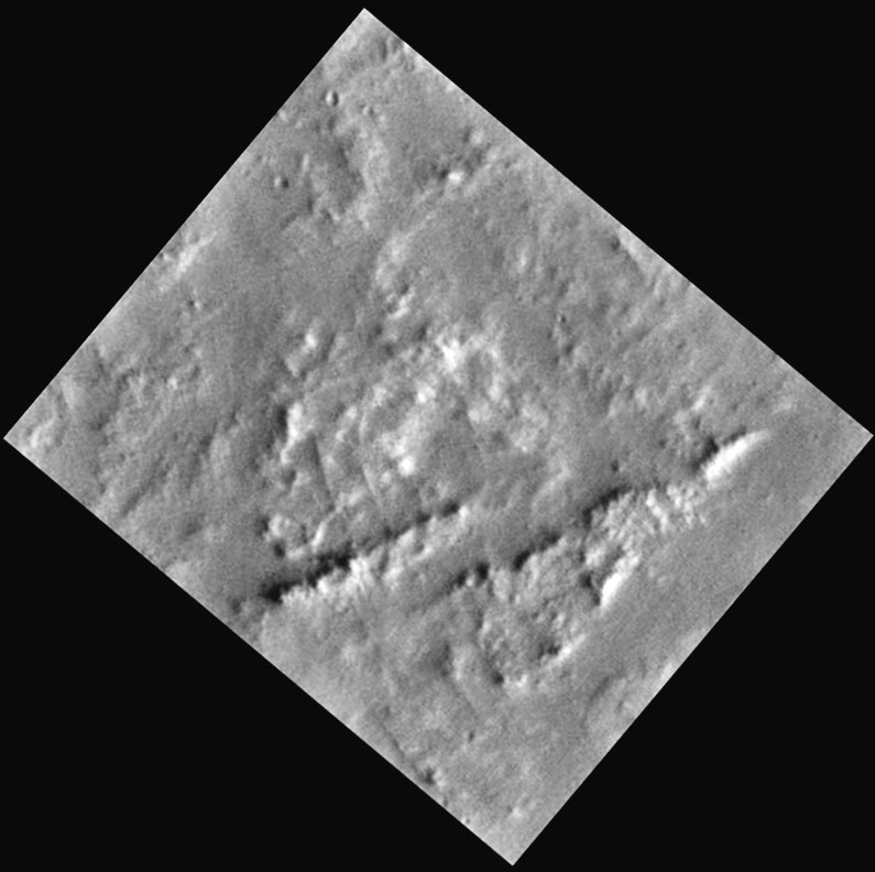
In terms of specific features on this landscape, what would future CRISM observations reveal about this (by now) familiar cluster of
"highly regular, geometric-spaced objects" from the initial MRO
mosaic ... exposed at the bottom of an ancient impact crater
(below)?

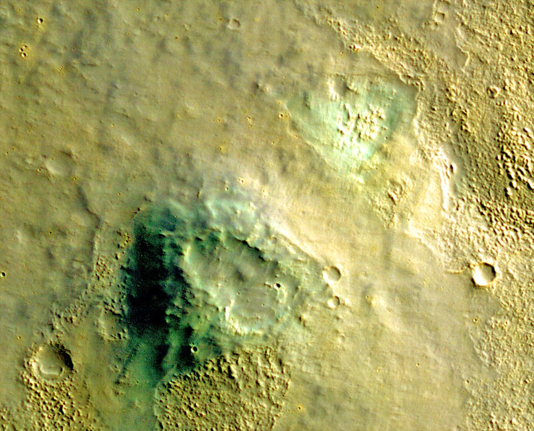
The color version of these enigmatic
structures from the color HiRISE image (below), reveals tantalizing
hints of what’s to come.

Not only is the highly ordered geometry
still present (complete with the delicate rectilinear detail seen
between the structures, also visible in the B&W version ...), the
color of these clearly organized objects is "greenish" ... at
distinct variance with the more neutral "grayish," windblown sands
seen between the structures and around the crater itself.
Something about these "geometric objects’" composition -- in this
false color HIRISE image -- is revealing a "greenish cast" ...
which, significantly, is NOT present in the windblown materials in
which they’re still partially buried!
A CRISM hyperspectral set of observations in the Fall could, in
principle, determine exactly what that "greenish stuff" could be --
its composition -- and if, in fact, that composition is consistent
with "naturally expected" desert Martian minerals for this region
.... or, if these objects are indeed made of something more "exotic."
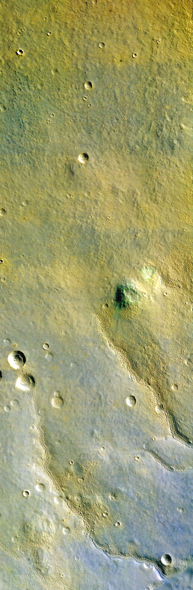
Looking back to the larger color frame (below) -- just to the
northeast of this anomalous collection of geometric "stuff" in the
crater floor -- there appear to be two curious "greenish triangles"
that immediately stand out as also "unusual" in this false color
view.
One appears to be a raised feature -- a roughly triangular-shaped
mesa. The other is clearly a shallow depression in the desert ...
with another collection of semi-organized features on its floor ....

An even closer view (below) reveals
tantalizing hints that we may be seeing more remains of ruins...

For, the green "triangular mesa"
contains a perfect right angle "base" on the upper right (northeast)
corner, as well as eroded geometry on top that eerily echoes this
same rectilinear pattern. This northeast/southwest alignment is also
shared by the collection of much smaller objects on the floor of the
near-by "green triangular depression."
Most striking, indeed, is the definite green color of both these
features ....
The same "green" -- which revealed itself in the rectilinear
collection of apparent structures in the nearby crater floor!
If these are, indeed, artificial remains of ancient buildings and
more massive Martian structures, eroding out of the desert sands
that had somehow originally buried them a long, long time ago ...
were both sets of objects originally made from the same artificial
alloy, or material ... which is now being detected as "greenish
stuff" in this false color, HIRISE view?
And, could future high-resolution CRISM observations of these same
features confirm such a possible scenario ...?
The answer’s "Yes!"
Again -- as with the B&W MRO mosaic released earlier -- we have only
"scratched the surface" of the details of this extraordinary HIRISE
color image. There is more ....
Stay tuned.
|