|

by Richard Hoagland
from
EnterpriseMission Website
"There are unimaginable
wonders [out there], for those who
can remove some of Truth's protective layers"
-- Astronaut Neil A. Armstrong, on the occasion of the
25th anniversary of the Apollo 11 landing
"The first thing we do, let's kill all the lawyers."
[Henry VI, Part 2]
-- William Shakespeare
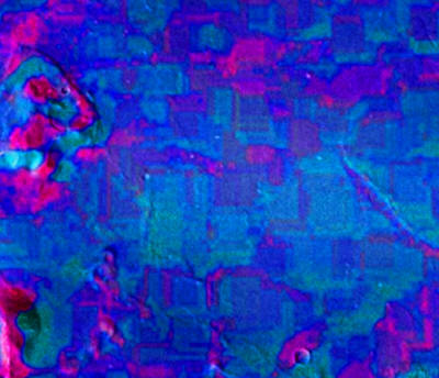
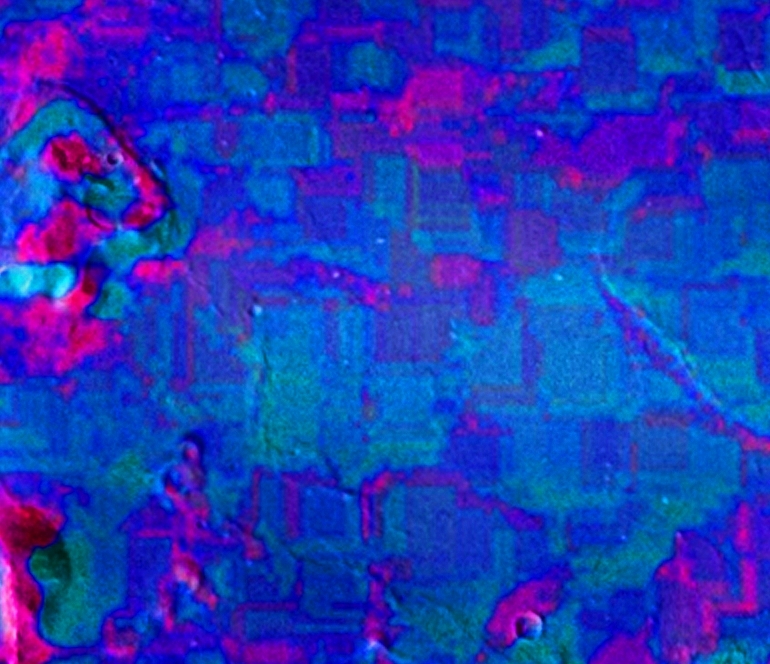
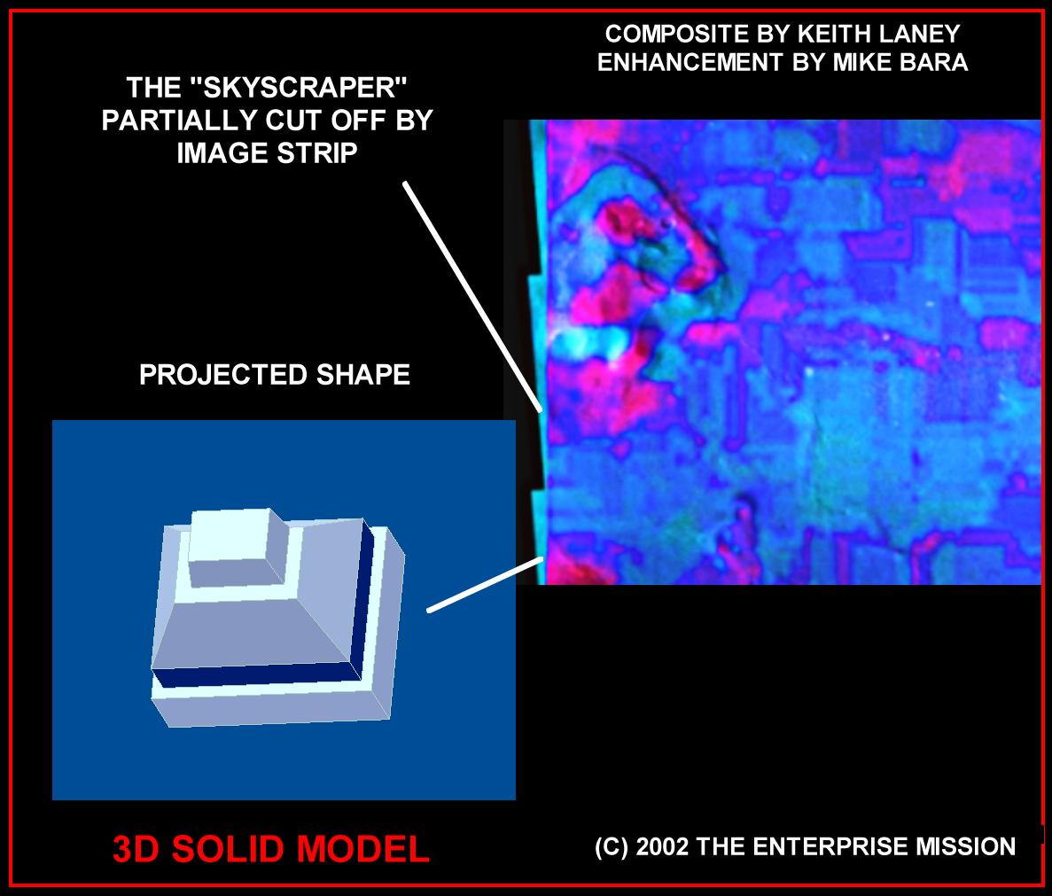
Enhanced
section of Mars Odyssey 2001 infrared/visible light composite.
Composite by Keith Laney. Enhancement by Richard C. Hoagland
For the last several weeks, since the
release of the Mars Odyssey 2001
THEMIS infrared images of Cydonia,
we have been working feverishly to produce a detailed, scientific
Report on our initial findings. As you may have surmised from our
numerous "Captain's Updates" and the image above, the discoveries we
have made in the course of extracting the first data from these
images have been overwhelming, even to our jaded eyes.
After more
than two decades of trying to tame this dragon, we stand tonight on
the Edge of Forever - finally holding the proverbial "smoking gun"
that should end once and for all the literal decades of repetitive
debate over Cydonia as an archeological reality.
It won’t of course - probably not for quite a while. But that’s not
our problem. Ours is simply to report the extraordinary new evidence
that we have found.
There can be little question now that what we are seeing at Cydonia
is "architecture." Although we have already made what we consider an
incredibly strong case over the years that certain objects at
Cydonia - including the famous Face on Mars - are artificial, the
latest THEMIS data is on a totally different level. As you will soon
see (when Richard finally posts his preliminary technical Report),
it will ultimately end this debate once and for all.
If only we could get the data to stand still.
In order for you to understand this central "problem" - and our
reasons for the great degree of confidence we are now displaying in
even our preliminary findings - we must first take you on a
"mini-tour" of that document Richard is still, after four grueling
weeks, painstakingly working to complete. We’ll begin by going back
to the beginning, in late July, 2002 … as we naively started to
address the data just released on the official THEMIS web site ….
As a deliberate choice, Enterprise Mission investigators, including
Richard Hoagland, decided early on to stay completely out of the
"processing phase" of this Investigation. We instead elected to
utilize the skills of two outside volunteers in image processing - who freely offered invaluable technical assistance at this crucial
time: Holger Isenberg and Keith Laney.
Neither were full-time members of our long-standing team of other
imaging and geological experts, whom we have previously turned to
over the years, but rather highly qualified and completely
independent recent "interested persons" in our work (Holger is a
graduate engineer for Applied Computer Science at Dortmund
University, as well as a Unix System and Network Administrator at a
German software company. Keith Laney is a digital imaging and
software applications specialist and MOC image processor for the
NASA-Ames' MOC MER2003 Landing Sites Project). We felt this would
give the maximum degree of credibility to our eventual results.
Since the other key factor in gaining credibility in scientific
circles is reproducibility, we also decided that Keith and Holger
should aim at accomplishing the same tasks, but work as separately
from each other as was practical.
Keith, at first, was not very enthusiastic about any aspect of the
"project."
Hoping to see a full color, multi-spectral image (per Dr. Saunders’
- Odyssey Project Scientist - "preview Web announcement," made
just prior to the July 24th release), Laney was so displeased with
what was eventually published on the THEMIS web site (a set of
grayscale, side-by-side, multiple-band image strips), that he didn't
even bother to download the composite THEMIS image the first day
(July the 24th, 2002) - flatly declaring that "it sucked," when
asked about it in the Enterprise Conference and on other message
boards across the Net.
Because of this highly visible position, Keith (and a few others who
had also publicly criticized the quality of the new image) than
began to get a series of interesting "responses" in the Enterprise
Conference and in private chats. These "responses" came from two new
visitors to our site: "BAMF," and one "Dan Smythe" The former had
begun posting about a month before the image release; the latter
appeared simultaneous with its release. Both of these new found
"friends" seemed to know quite a bit about "infrared image
processing," and pretty much goaded Keith into finally going back
and processing the full-size TIFF file - which (according to his
own computer log) he had downloaded on the 25th of July, at 10:27 PM
EDT.
We were, from the get-go, more than a tad "suspicious" of both BAMF
and Smythe, and that suspicion only deepened when we discovered that
"BAMF" was in fact none other than "Noel Gorelick"
- who claimed
(in his on-line Enterprise Conference profile) to be the Manager of
Arizona State University’s Mars Computation Center. Gorelick went on
to further claim that he was in fact the person who had
hand-assembled (over a period of four days) the infrared Cydonia
image posted on the THEMIS web site!
While from the beginning publicly acerbic and disparaging of the
very reason for the existence of Enterprise - as a platform for
scientific investigation and discussion of possible artificial ruins
on another world, imaged by a variety of NASA missions - privately,
"Bamf" and Smythe provided Keith and Holger - and anyone else with
the smarts to work with the new image - a virtual on-line "how-to"
tutorial in "infrared image processing." In fact, Gorelick was so
helpful, so omnipresent (spending literally hundreds of hours in
both the Conference and in "chats"), that we began to suspect that
there might be "more than one of him" … suddenly "living
electronically at Enterprise" from ASU.
Using the image he had downloaded on the 25th, and working with a
state-of-the-art software suite that included ENVI 3.5 (a superb
remote sensing software enhancement product created by
Research
Systems Inc. a division of the Kodak Corporation - which provided a
crucial "decorrelation stretch" tool) once he "got the hang of it,"
Keith began to achieve astonishing results.
His initial color ratio
composites – from the nine strips of drab B&W imaging he had
downloaded from the official THEMIS website - were nothing less
than stunning (below).
In addition to a whole new IR perspective on the "long-familiar
features" of Cydonia – the Face, the D&M, etc. - Laney found a
troublesome, quasi-regular pattern of easily discernable pervasive
rectilinear markings … running almost the entire length of each band
of the IR Cydonia strips. When he queried Gorelick about the
annoying "blockies" (as he called them), "BAMF" grudgingly admitted
"so, you've found our dirty little secret."
The ASU Manager
acknowledged that the THEMIS team had also seen this peculiar
"noise," and had decided NOT to create the normal, multi-spectral
color images produced of other areas on Mars from the same THEMIS
camera … because of this disfiguring pattern. Remarkably, he also
admitted that, despite their best efforts, they could not seem to
remove the "noise" … or find it on other published IR THEMIS images.
It seemed singularly unique to the Cydonia THEMIS IR images ….
Keith then began feverishly working on his own methods to remove
this offending pattern – even sharing a couple of "destriping
tricks" with Gorelick (who was quietly soliciting outside assistance
on the problem) in the process. But, ultimately, he had no more luck
than the official THEMIS team.
Around the same time, Enterprise principal investigator Richard C.
Hoagland (who was following this unique exchange between "Bamf" and
Laney via e-mail) decided to suggest a radically different process
for eliminating this peculiar noise, a well-known technique for
"noise averaging" used for decades in astronomical photography
- called "luminance layering." Hoagland outlined adding the earlier
Odyssey visible light image (released April 12, 2002) to the
stunning three-color IR composites Keith was creating from the
latest THEMIS release.
Laney, remarkably, had at about the same time
independently decided to do the same thing! Once Keith did this - essentially "adding" the visible light image to the color stretched IR data (below)
- things rapidly got very interesting.
What both men found to their surprise was that the pattern not only
wouldn’t go away … it actually got more pronounced. It suddenly
struck Hoagland that what he and Laney (not to mention the THEMIS
team itself!) thought was "noise" in the Cydonia images might really
be the signal. Working on this radical assumption, Hoagland switched
gears and quietly urged Laney to start trying to amplify the pattern
in his on-going ENVI processing of the "raw" data, rather than
continue efforts to remove it.
At the same time, taking the composited VIS/IR "decorrelated"
versions Laney already had completed, Hoagland began a few
experiments of his own ….
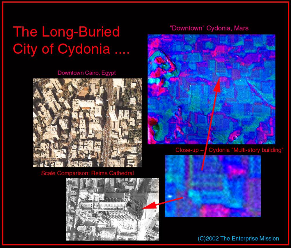
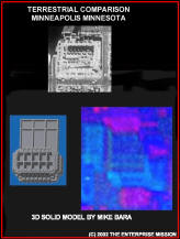
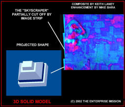
That's when the "cityscape" - the mile upon mile of individual,
clearly artificial structures hiding beneath the dusty plains of Cydonia
- became completely obvious.
By simply increasing the image saturation of the composite VIS/IR
image (below), what had been "an annoying and mystifying block
pattern," suddenly was revealed by Hoagland to be a stunning, highly
detailed city … silently sleeping for untold ages "beneath the
timeless sands of Mars" …..

Our usual critics will at this point begin arguing that this is
simply "enhanced noise," or, that we have somehow "made all this
up."
In reality, it is fairly easy to put such notions to the test. For
one thing, the pattern does NOT follow the scan lines of the imager,
but rather true Cydonia north and south - exactly as terrestrial
cities (especially "modern" American ones) most often do. In
addition, there are a wide variety of individual "structures" which
do NOT conform to this north/south grid at all. We are completely
confident that these structures are not "noise," since they show, in
both layout and design, clear evidence of architectural intent and
organization.
And even the smallest structures are at least an order
of magnitude (ten times) above the (very low) noise threshold of
these superb VIS/IR composites – both in terms of resolution as well
as intensity.
Without any further enhancement, massive individual structures
simply "fell out" of the data by simply turning up the color
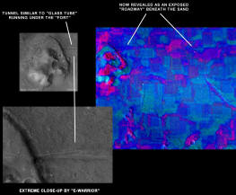
saturation. Previously identified features, like the "tunnel"
running out of the Fort, could now be seen to continue out across
the Cydonia plain … literally under the soil ....
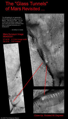
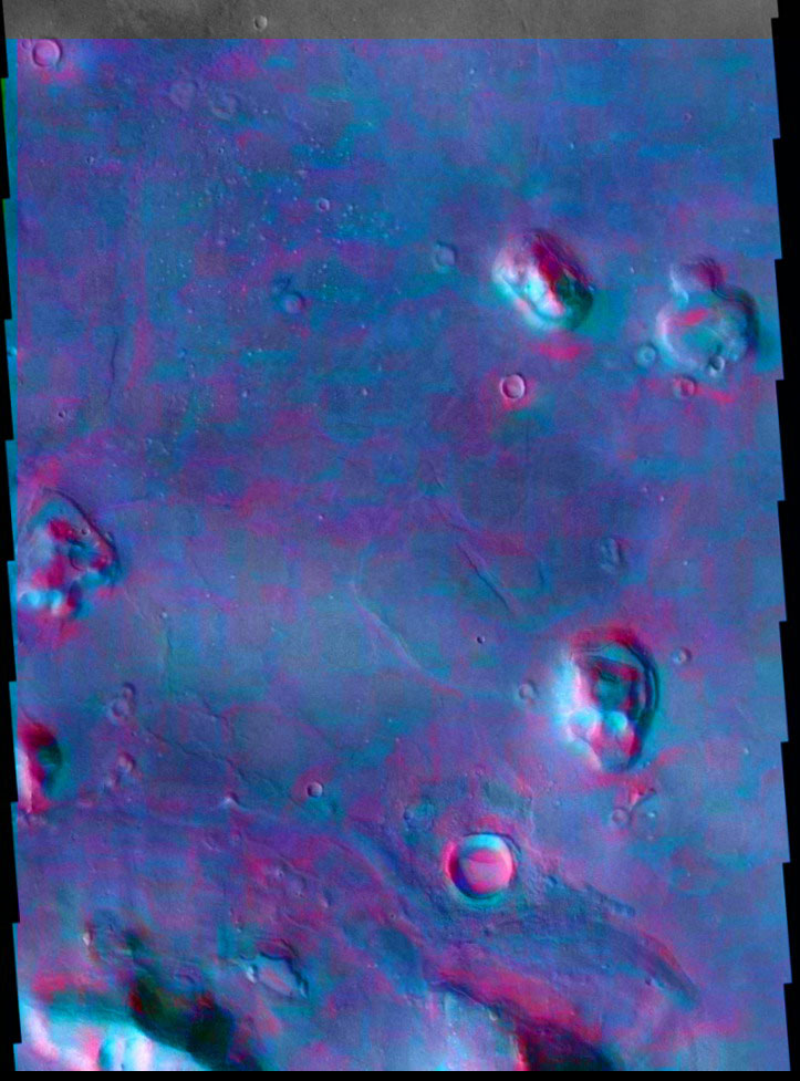
First noted by us because of its similarity to the "Glass Tunnels"
(above image) Hoagland found several hundred miles west of Cydonia two years ago,
and that got Arthur C. Clarke so excited just last year, we said at
the time (to howls of protest) that this "linear Fort feature" was
consistent with our model that the "Glass Tunnels" were some kind of
subterranean "transport system."
The exposed portion of the "Fort
tunnel" is clearly visible even in the Viking data from over 20
years ago, and runs out from underneath the Fort at a roughly 60°
angle to the Face-side wall. However, in the visible images, the
tunnel runs for only a few hundred feet before it disappears beneath
the Cydonian sands.
In the more recent B&W visible light MOC images we have received
from MGS (Mars Global Surveyor), the close-up view of the tunnel
(below) revealed that it has a distinct rib cross-structure - strikingly similar to the other Martian "Tunnels" we had found
(which our NASA critics, with boring predictability, dismissed as
simple "dune trains").
MOC Enhancement by Keith Laney
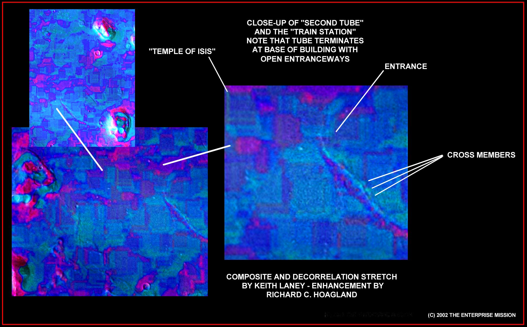
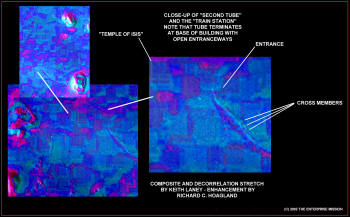
On the Cydonia VIS/IR composites, we found more of them (below).
One new "transport tunnel" emerges from the base of a "building" we
are now calling the "train station" in "downtown Cydonia"
- and
runs straight into the "mesa" just south of the Face (and just north
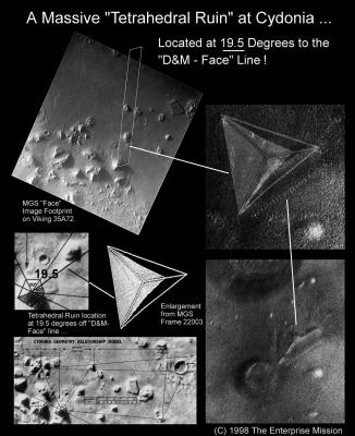
of the massive tetrahedral ruin - below image - we first noted on the "Catbox"
image).
In fact, it runs into the "mesa" (which, from the new IR
data, we are strongly suspecting is NOT even a "mesa") at the exact
lateral center of that massive above-ground structure.
Close
examination of the other end of the tube (below, right) shows that
the "tunnel" terminates at the base of the "train station" directly
in front of a series of striking open archways in that building!
What is absolutely clear from the new THEMIS enhancements is that
the "tunnels" are indeed just that. The THEMIS image allows us to
see that the "Fort tunnel" is not just a simple depression in the
landscape, but a coherent, tubular feature that runs for many miles
beneath the Martian desert and across the Cydonia plain into the
heart of the buried "Cydonia city."
There are also clear structural
cross-members - massive in scale - that run 90° to the tunnel at
various points along its traverse, as well as its companion tunnel
leading to the "mesa" south of the Face. Architects and engineers
will again quickly recognize these features as obvious evidence of
intent and design. The simple fact that the tunnels can be seen to
continue below the ground, is clear evidence that they are not
natural formations of any kind.
Some (NASA) geologists will probably try to claim that the features
are "lava tubes," or some other nonsensical ad-hoc explanation. But
just how they reconcile that vain hope with the multi-story
buildings we see all around these linear features will be
interesting to watch.
This should also, for all intents and purposes, end the debate with
geologists like David Pieri as to the reality of the other "glass
tunnel-like features" we (and other "anomalists") have now found
literally all over Mars ….
And there are the other, even more unimaginable wonders on this
THEMIS image.
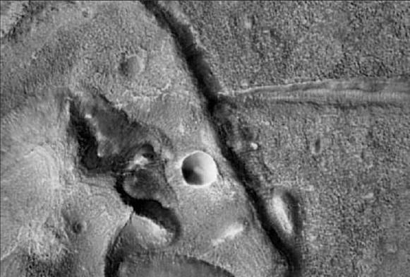
The most prominent being a stunning, overwhelmingly architectural
structure we are now calling "The Temple" (below).
You can clearly see, without even straining your eyes, the
individual cells and what appear to be decorative buttresses all
around this multi-story structure. This object, just east (to the
"Face side") of the Fort, is an architectural marvel - clearly a
structure of significance and, with the exception of its apparently
missing roof, in nearly pristine condition.
Sharp eyes will detect numerous other completely obvious buildings
of various types scattered all across the image. We can and will
identify many of these individual structures in our image gallery
and in our follow-up Preliminary Technical Report (which we will
post in the next few days).
For the moment, let's just feast our
eyes on a couple of other wonders, and contemplate the reality of
"the Lost City of Cydonia" ....
Not only is this model completely consistent with our previously
published
Mars Tidal Model, it is also the only explanation for
these buried features we are seeing on the IR composites. It is also
the only reasonable explanation for why we’re seeing them at all.
Long wave infrared imagers have a limited ability to penetrate
underground, by detecting surface "hot spots" conducting heat upward
from below.
But they cannot possibly show the kind of detail we are
seeing … unless … we are sensing our "city" through a layer of
"fluffy, micron-sized dust" essentially transparent to the THEMIS
wavebands ... covering another, thicker layer of protective (and
also IR transparent) ice.
But given the now confused state of the paper trail of this data,
how do we know that our images are "real," how can we so confidently
claim - besides the obvious visual clues already laid out - that
these objects are really there, really mummified in an icy coffin
just beneath the surface of Cydonia?
That is really beyond the scope of this article, and will be fully
addressed in Richard's technical Report.
However, we will highlight
a few additional points here.
Just as we were ready to "go to press" two weeks ago, we suddenly
became aware that the original THEMIS daytime IR image of Cydonia
posted on the website may have been altered. The first hints came
when Holger Isenberg (remember, the other imaging associate
working from Germany), was unable to duplicate our key results.
Holger was not working with precisely the same software suite as the
rest of us (ENVI 3.5 was unavailable to him, gratis, unlike Keith’s
copy, in Europe), which was both a good and bad development. For, it
inadvertently gave us a chance to compare the results when two
different, but functionally similar sets of imaging tools were
applied to the same IR data.
The first assumption was that there might be something that either
he or we were doing "wrong" that gave us differing results. We
eventually discovered that Holger was using the .PNG version of the
THEMIS image, as opposed to the full size .TIFF that the rest of us
were working with. But, that did not account for the entire
discrepancy that we were seeing. PNG's are a fundamentally solid
file format, completely lacking the "lossy" compression problems of
JPG's of GIF's.
Beyond that, the objects that we were finding were so big, so far
beyond the noise level of the image and so easy to bring out (once
the compositing of the IR bands had been done properly), that even
with a compressed web image file format, Holger should have seen
these objects literally jump out at him. Instead, there seemed to be
a distinct lack of information in the images he was processing.
And all of this came on the heels of the dramatic and curious
developments of the preceding week or so. Our new found "friend,"
BAMF, aka Noel Gorelick of ASU, made some emphatic statements that
seemed to fly in the Face (!) of his previous attempts to help our
efforts. On or around August 20th, 2002, Gorelick made what seemed
at the time to be a bizarre and arrogant claim.
He insisted he had
the power - and indeed the right - to flagrantly alter the data
posted on the official THEMIS website… at his whim.
To quote him
verbatim:
"The daily images web site is a service I provide and support
entirely because I'm a nice guy. There is no NASA mandate or
contractual requirement for me to provide these images to anyone
before they're delivered to the PDS. I do so because the public is
interested in what's going on with the mission, and it's good for
public relations.
Accordingly, if I feel like degrading the data
before I post it, I'm certainly free to do so. If I want to scribble
on the images with a crayon before posting them to my web site, I'm
probably free to do that too. The 'government data' that the public
paid for is being well cared for while it's being prepared for
delivery to the PDS."
-- BAMF, aka Noel Gorelick
Tagged onto an earlier, equally strange statement in the same vein
made by Gorelick - claiming that "no one can tell if an image has
been fundamentally altered …" - we began to become more than a tad
concerned.
This, in turn, led to us withdrawing from our original
plan to post the infrared Cydonia THEMIS data and our Preliminary
Analysis on August 22, 2002 - while we rechecked our data’s
fundamental integrity and lineage.
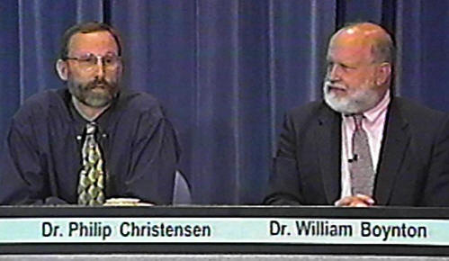
And that prompted an immediate response from ASU's Dr.
Philip
Christensen, the Principal Investigator for the Mars Odyssey 2001 THEMIS instrument. He sent us an email late in the evening on August
the 22nd, as if he had been waiting either at home or in the office
for our appearance on "Coast to Coast AM."
The complete text of his
email to Enterprise associate investigator Mike Bara read:
Dear Michael,
I am confused by your statements regarding the THEMIS IR data and
your decision not to release your findings. The data were calibrated
[sic] our standard processes and in the same way that is done for
the THEMIS science team. I am not sure why you are suggesting that
Noel, or anyone else on the THEMIS team, has done anything to alter
the data - he was simply questioning how you have treated the data
and how you have validated your methods and processes.
I look forward to your release and to a detailed description of
exactly what you have done to the data once you have downloaded
[sic] from our web site. Hopefully you will provide an accurate
description of these techniques and the methods that you have
employed to validate everything you have done to the data.
Sincerely,
Phil Christensen
THEMIS Principal Investigator
At this point, we made a conscious
decision to pretend in public that we were more than satisfied with
this response. The truth was, it only deepened our concern. Not only
does Christensen's e-mail make a blatant misstatement - Gorelick certainly did imply he might
have altered the data (and more than once), and was NOT simply
"questioning how you have treated the data."
And, if threatening to
"scribble on the images with a crayon" doesn't strike Christensen as
a reason for us to imply that Noel might have done something
untoward to the data, well, Phil, what would qualify?
But the most disquieting part of the email was Christensen's
inordinate interest in our "methods and processes." Why was he so
interested in what we had done to the data, when he himself and his
own team had provided nothing to the public (which, Gorelick's
assertions to the contrary, owns the data) about what they might
have done to it? The THEMIS team hadn't provided any description as
to how the data had been handled, treated or possibly "enhanced."
They hadn't provided the slightest hint of what filters may have
been applied, a paper trail of who had handled it, or even the most
rudimentary ancillary data (spacecraft geometry, lighting, etc.) for
any of the released Odyssey images. If they weren't even willing to
provide the date, time, and orbit number of the THEMIS Cydonia
image, why would they be soooo interested in us providing an
"accurate description" of what we had done?
We didn't quite know yet, but we knew we needed to find out.
So we went back through the data stream and tried to find any
discrepancies in either our processes or tools. The one thing that
kept coming out was that Holger Isenberg just did not seem to be
getting the same results as Keith Laney. In fact, he wasn't even
coming close. Granted, he didn't have full use of ENVI (because he
could not get a temporary European license for it), but that alone
didn't seem to fully address the striking differences ….
Keith was non-plussed by this problem. After initially thinking that
Holger just wasn't "getting it," he finally decided to retrace his
own steps, go back to the THEMIS web site and download the image
"one more time" and literally start from scratch, working with
Holger step by step (at this point our "separate but equal
processing strategy" seeming to effectively have run its course).
When he did so - to put it bluntly - he (and we!) got a major
shock.
When he brought up the two images side by side … the one he’d
downloaded on the evening of July 25th, and the one he just
downloaded again from the exact same official THEMIS website on the
evening of August 25th … they didn’t match.
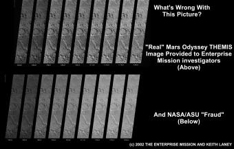
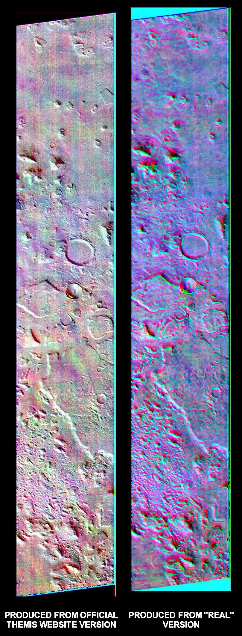
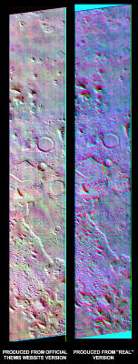
As you can clearly see from the comparison graphic (above), Keith's
original July 25th version is noticeably different – even to naked
eye inspection - from the one currently posted (as of this writing)
on the official THEMIS web site.
In Keith's version, you can plainly
see the block pattern, or part of it, even in the so-called "raw"
data - without any computer processing. In the official THEMIS
posting, these "blocks" are completely absent.
The differences become even more striking when standard IR
enhancement processes are applied. In Keith's version, he can easily
replicate his previous results (with ENVI) and get down into the
data. The result is a beautifully clean, IR composite image - with
very little noise (below, right).
When he uses precisely the same
processes on the "official" website version, the result is absolute,
unadulterated, "noise-filled crap" (left image, below).
Some readers in the Enterprise Conference have been confused because
in the "raw," the official version seems noticeably sharper. In
fact, this is apparently because it has had a sharpening filter
applied to a visual image overlaying the IR. The "real" one (in our
published version) had a mild (0.42) Gaussian blur applied to it.
Keith mistakenly applied this to the original image in an attempt to
enhance what appeared initially to him to be a "fuzzy," noisy image
(attesting to the absolute limits of simple visual inspection of IR
data for meaningful content!).
Fortunately, he saved an unblurred
copy of the original - which we intend to publish as corroboration
that, in fact, our "real" THEMIS IR Cydonia image was originally
untouched.
In any event, this should not be a major cause for concern.
As the ENVI software manual points out, in a true multi-spectral IR
image, you cannot "destroy" or add to the data with a simple filter,
like a "Gaussian blur". You can only enhance it - because each
individual IR pixel retains the same base intensity data that it had
originally (D&M image, below right).
On the other hand, if you
reduce the resolution with resampling, overlay a visible light
image, and then apply a sharpen filter (while adding an unknown
amount of pure "white noise") - as apparently has been done with
the "official" website version (below, left) - then you will get
pretty much what we see on the (obviously!) degraded version ....
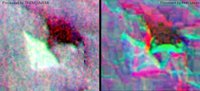
The D&M Pyramid, processed using the "official" version of THEMIS IR
Cydonia image (left)
and the "real" version (right). Note the similarity in color
distribution on both images, and the unmistakable
structural details of the D&M itself in the "real" version. Both
images composited, color ratioed, and decorrelation stretched
using ENVI 3.5 image enhancement software.
The aforementioned "noise filled crap."
So what is happening here?
Our conclusion, based on a number of facts we will lay out below, is
that the image Keith has is a genuine, or at least "close to a
genuine," Mars Odyssey 2001 THEMIS IR image. What is currently
posted on the THEMIS web site, and what was apparently posted on the
24th of July 2002 when the vast majority of interested parties
downloaded it, is a highly modified, highly degraded image of
unknown origin.
In other words; a highly diluted fake. A deception, deliberately
perpetrated on the American people by "someone."
A BIG LIE.
Indeed, if you read the abstract of Dr. Christensen's own recent
paper on the THEMIS results, "New Observations of Mars from the
Odyssey Thermal Emission Imaging System," he makes it quite clear
that the instrument is more than capable of achieving excellent
"ground penetration."
To quote from the abstract:
"Regional 100-m mapping has revealed the presence of channel systems
in ancient crater terrains not detected by Viking and not mapped by
the high-resolution camera on Mars Global Surveyor."
In other words, "We're seeing stuff with the THEMIS instrument below
the ground that can't be seen on the visible light Viking or MGS
images." Now again, revisit the graphic above and ask yourself which
of those two images is consistent with Christensen's previously
reported results, and which one seems to be practically opaque.
Kind of makes you wonder what might be under the ground at Cydonia
that they don't want you to see, doesn't it?
Faced with this discrepancy, we elected to hold off last Thursday
night, August the 29th, 2002, and instead simply put the source data
out side by side so that it could be evaluated. We waited to see if
there was a response from Christensen, but when none was
forthcoming, we elected to take the initiative and simply send an
email. We also attached a copy of the "real vs. official comparison"
we had posted in our story.
Here is the full text of our initial query:
To: Dr. Phillip Christensen
THEMIS Principal Investigator
Arizona State University
From: Richard C. Hoagland
Principal Investigator
The Enterprise Mission
P.O. Box 3550
Edgewood, New Mexico,
87015
SUBJECT:
DISCREPANCIES IN THEMIS INFRARED DATA POSTED ON THE THEMIS
WEB SITE
Dear Dr. Christensen,
I am writing you today because of a vexing problem my team has
encountered in trying to make use of the THEMIS Cydonia infrared
data your team posted to the THEMIS website on July 24th, 2002. In
the course of working with this data and attempting to extract the
information through normal enhancement processes, we have discovered
at least two and possibly as many as four distinct versions of this
image have been posted on the THEMIS public web site at
http://themis.la.asu.edu/zoom-20020724A.html
at various times.
These differing versions of the source data are
difficult for us to explain away as some sort of bureaucratic error
on your team¹s part.
All of the images in question have slightly differing text in the
header tags attached to the images, although several appear to be
made from a PNM source image, so it is possible they may have come
from the same root source image. There are also numerous visual
differences which are readily apparent upon even a rudimentary
inspection and comparison. The image which appears to have been
posted initially on the THEMIS website, and apparently upon which
the image caption (and several poorly researched news stories) seem
to have been based is in marked contrast to later version downloaded
by other members of our team.
In fact, it is so distorted by noise
and so lacking in data at the grayscale level that we do not
consider it useful for even casual research. It also displays
numerous characteristics that lead us to conclude on a preliminary
basis that it is actually a visible light image and not an
infrared image at all, although it may be simply a visual image
strip overlaid on the original IR data. In any case, it is not
useful to us and we doubt it would be of any use to other workers.
Conversely, a very different version of the composite IR image
strips was obtained from the THEMIS website by another member of our
team that is very rich in detail and free of the noise that renders
the official version useless for our purposes. We have determined
that this is not due to any error on our part, or lack of capability
of the THEMIS instrument, or improper calibration of the data.
This
difference is therefore one we are hard pressed to explain and I am
hoping that you will be able to illuminate the issue for me. Is
there some compelling reason why the images available for download
on the THEMIS page I linked above would be changed without warning
or acknowledgment on the website itself? And if there is, would you
be willing in the future to publicly acknowledge such changes in the
image caption when a new version is released?
Given the concern you expressed in your email to my colleague Mike
Bara on 8/22/2002 about our handling of this data, I¹m sure you can
appreciate the difficulty of publishing even preliminary conclusions
about a dataset that keeps changing without notice. It would also be
helpful if you would at least publish the date, time and orbit of
the spacecraft for this image, along with all of the other ancillary
data normally expected in a data release of this type. Dr Stephen
Saunders has sent an email that says, "My official position is that
there is no proprietary period for the exclusive use of mission data
by the investigators."
I take this to mean that any hold-up in the
release of the ancillary data for THEMIS IR image 20020724A is
purely an administrative issue for your team. However, due to the
intense degree of public interest in this matter, I respectfully
request that you expedite the process for this image and provide the
data immediately.
I'm sure you agree that the public who paid for this mission and
your instrument should have access to the same information as NASA
researchers do through the PDS database, and in a timely manner.
I might also suggest that the image you currently have posted on the
official website, which appears to have so much noise in it, should
be pulled in favor of the much cleaner version we have found.
Independent researchers will have a much easier time replicating our
work if they have access to the same database as we do.
Our job would also be made considerably easier if you would have a
member of your team simply send us the nine individual IR band image
strips (6.62µm[x2], 7.88µm, 8.56µm, 9.30 µm, 10.11µm, 11.03µm,
11.78µm, 12.58µm) as single files, uncompressed, without rotation,
without reducing them in size or resolution, and in TIF file format.
Please consider this a formal request.
For your consideration, I have attached a comparison of the ³better²
version of the THEMIS Cydonia infrared data we have obtained from
the website linked above, and the official one currently on your
site. I¹m sure you will conclude that it is far superior to that
posted on the website on July 24th 2002 and at various times since
that initial posting.
Please feel free to contact me or Mike Bara
with a any questions you may have pertaining to any of the issues I
have raised in this communication.
Cordially,
Richard C. Hoagland
09/02/2002
On September 3rd, Christensen responded:
Dear Mr. Hoagland,
We created the THEMIS image that is on our website on July 22. That
image has been posted continuously since it was first made
available. I have no idea where you got the images that you have
been posting and discussing, but the data on our site has not
changed. I looked at the image you posted last week that you
humorously claim to be "real". You have clearly processed and
tinkered with these data - I note that even the lettering at the
bottom of the "real" image has been filtered...
Phil Christensen
Of course, Christensen had noted the Gaussian blur filter that we
mentioned before had been applied to the image. But we found it
rather odd that he hadn't looked at the data closely enough to
notice that his official version was completely inferior to the
"real" version Keith had obtained from his own website.
Choosing to
assume the best - that he simply hadn't looked close enough - we
responded again, and this time included a side-by-side comparison of
two of the color ratioed and decorrelation stretched images we have
posted above.
He would clearly be able to see the difference.
Our response:
Dear Dr. Christensen,
I can understand your confusion on this issue, however I can assure
you of two things:
1. We have not "tinkered" with the real image in any way. The
lettering looks different because a mild (0.42) Gaussian blur was
applied to the image as an attempt to enhance it. Subsequently, the
person who obtained this image has discovered that he did keep a
completely unaltered version of the source data, and we will be
publishing that along with a full explanation of this minor
discrepancy on Thursday. I am sure you know as well as we do that
this filter is used as an enhancement tool, and cannot account for
the differences between the two sets of images.
2. We did not mean to imply that you personally had anything to do
with the striking differences in these two data sets.
I take your statement that the data on your site has not changed to
mean that you have verified this with the person who is in charge of
creating and maintaining the web pages, which I presume is Noel Gorelick. In case you are not aware of it, Mr. Gorelick has made
several curious statements during his visits to our Conference area.
To quote him:
"The daily images web site is a service I provide and support
entirely because I'm a nice guy. There is no NASA mandate or
contractual requirement for me to provide these images to anyone
before they're delivered to the PDS. I do so because the public is
interested in what's going on with the mission, and it's good for
public relations.
Accordingly, if I feel like degrading the data
before I post it, I'm certainly free to do so. If I want to scribble
on the images with a crayon before posting them to my web site, I'm
probably free to do that too. The "government data" that the public
paid for is being well cared for while it's being prepared for
delivery to the PDS."
Obviously, Mr. Gorelick is implying that he has the right to alter
data published on the THEMIS web site. Whether he did this or not we
are not certain. However, we have no doubts about the integrity of
the person who supplied our source data for the real image, nor do
we assert that the "real" image has been "degraded" in any way. In
fact, if you examine it closely using proper imaging procedures, you
will see that it is far superior to the "official" version that is
currently on the THEMIS web site (see attached).
Finally, we can tell you that the person who downloaded the "real"
image did so from a website that appeared to be either the genuine
THEMIS web site, or an exact copy of that site. How this may have
occurred is somewhat mysterious to us, but you may discover a hint
if you do some research into Mr. Gorelick's nickname that he used on
our message board, "Bamf."
Cordially,
Richard C. Hoagland
PS I have included a side-by-side comparison of the data from the
version on the THEMIS web site and the version we believe is real.
Both images have been processed precisely the same way utilizing six
properly ratioed bands, and a decorrelation stretch. Since our real
image shows virtually no noise and your website image is almost
submerged in noise, this has led to our questioning of these very
diverse datasets. It should be obvious that one cannot take the
noisy website image, and produce the noise free version.
He couldn't avoid seeing the difference this time, could he?
Well, evidently he could. Since we have sent him this communication
and the comparison enhancement, we have heard nothing now … in
almost 48 hours.
We think his silence speaks volumes. But regarding what exactly,
well ...
Now, before we discuss the scientific and political implications of
this latest NASA sponsored fraud, let's go over some of the other
points which make it overwhelmingly clear to us that the image Keith
is working with is the "real deal." Our analysis has resulted in
four separate proofs that lead us to this conclusion. In addition,
there are several other, finer points that reinforce our stance.
First: we know that Keith's image and the official image probably
don't come from the same source. The header tag in Keith's version
shows that it was converted from a PNM format, a standard conversion
format used inside NASA to process remote probe images.
In Holger
Isenberg's opinion (remember, he's a UNIX administrator for a German
software company), Keith's image was also processed on an older
UNIX-based computer - typical of the type of equipment used by
universities and the government. The "official" version, on the
other hand, appears to have been processed on a Windows based
machine and shows no sign of having been converted from a PNM. So,
there is nothing inconsistent in the header tags with Keith's image
being the genuine article.
Since we are all used to working with data in the visual light
spectrum, we have been taught to assume that "sharper is better."
Which it is - if you are working in the visible light bands.
However, visual resolution does not equate to infrared sensitivity
or information "richness." The "real" image, while it may look a bit
blurry, in fact contains far more data than the "official" version,
no matter what the "official" version looks like on first (naked
eye) inspection. That's why the processing and enhancement tools
used for multi-spectral imaging, to accomplish exactly that, are
crucial to extracting that signal from this set of IR images.
When you do a visual inspection of the two sets of raw data side by
side (or, in our case, one over the other), there are additional
visual clues that will tell you that the "real" version is true
THEMIS IR data, and that the "official" version is (at best!) a
"poorly rendered copy."
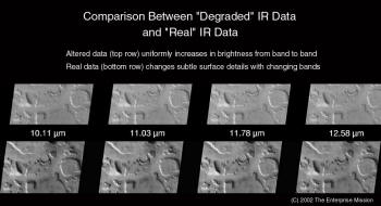
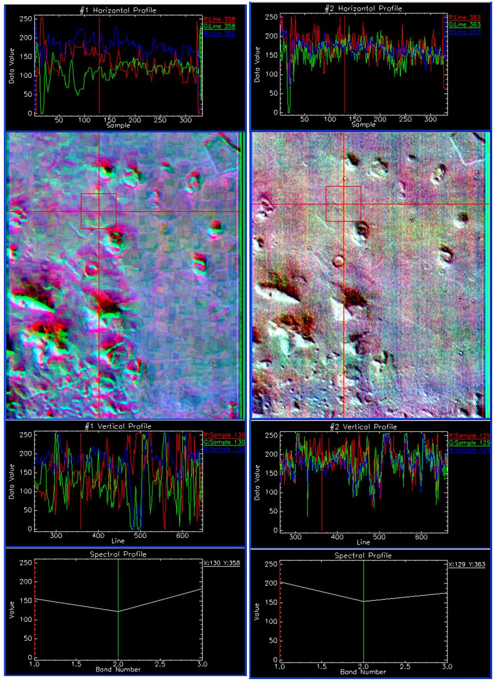
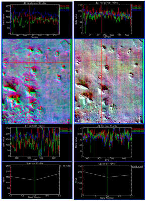
The first proof of this can be found with a simple visual inspection
of some specific features in the "raw" versions of both the "real"
and "official" versions of the THEMIS Cydonia IR data (above).
In Keith's real version, there are subtle but distinct differences
in specific features from frame to frame (bottom row). This is what
true IR data should show - because each signal return in each
individual IR waveband is going to find (in the "dusty surface
model") a slightly different "bottom" on the planet below. The
longer wavelength signals will penetrate more deeply than the
shorter wavelength signals. As an inevitable result, there will be
subtle changes in the appearance of certain features ... but only if
they are "real" features on (or just below) the planet's visible
dusty surface!
Conversely, in the official version of the Cydonia "IR" dataset (top
row), you see NO difference from frame to frame as you go up the
infrared bands. All you can see is steady, overall "brightening."
This proves that the top layer of the "official" version is not only
not real IR data, but that someone must have simply brightened the
entire image, or methodically darkened the individual image strips,
in a blatant attempt at misdirection - a blatant fraud made up to
look like "real IR data" to the uneducated eye.
The second major proof validating the "real" version is obtained by
a comparison of specific features in earlier visible light images of
Cydonia. There are numerous areas on the Odyssey, MGS, and Viking
visible light images which can be inspected and compared to the
"real" IR data. When we do so, we would expect to see some of the
"block" features that appear in the infrared to also appear in the
visible light images, assuming that some of these buried structures
are actually near the top of the dusty, icy layer.
Again, this in fact is exactly what we see (below) ….
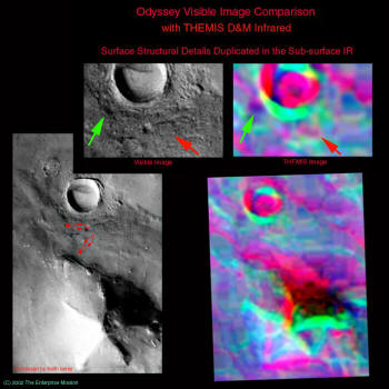
This is a side-by-side comparison of two typical "blocks" from
Keith's processed IR image, located on the platform just north of
the D&M Pyramid. As you can see, the very obvious block features
directly correspond with features from the decorrelation stretched
IR image.
There are numerous other examples of similar features,
which will be included in Richard's full Report - but the point is
that if these were processing artifacts (or "scanner marks," as one
person actually suggested), then there would not be any correlation
between visible features and the IR "blocks."
The existence of even
one correlation constitutes a "proof" that the blocks represent real
features - on or just beneath the Cydonia dusty plain.
The next proof is in the analysis of the "noise floor."
As you can see from the ENVI-generated side-by-side comparison
(above), Keith's version is much clearer, shows far more detail, and
simply contains far less noise than the "fake." What the graphs are
showing you is that the "real" image (on the left) has a much wider
range of spectral data in it, owing to the enhancement capabilities
of the ENVI 3.5 de-correlation stretch technique and the much cleaner
source data.
The image on the right (the official version) may have
actually been generated from the same original, but as you can see,
the spectral range of the image - in essence "the signal"
- has
been deliberately compressed, resulting in the extremely noisy and
scientifically worthless (by comparison) visual image on the right.
In short, if you were working with the data on the right, you
couldn't see the proverbial forest for the trees, or in this case,
the artifacts for the Artifacts ....
This second major point - which numerically validates for us the
entire reality of Keith's version - is that it is entirely
consistent with the kind of quantitative results one would expect
from the exquisite THEMIS instrument. While the "official" version
is entirely inconsistent with what that amazing instrument is
capable of producing.
According to this JPL document (also still available on the web in
HTML despite the .pdf being removed after we downloaded it), the
THEMIS instrument is accurate to plus or minus 0.001K (one
thousandth of a degree Kelvin) temperature measurement. That means
that it is capable of differentiating temperature differences –
instrument thermal "noise" - in increments THIS incredibly precise.
What that translates to visually is brought out when you
de-correlation stretch the images - as Keith has done with ENVI 3.5 - essentially separating the thermal data from the compositional
data, to allow you see more detail in the "composition bands." And
that is why, when we add the visible light overlay to the "good"
THEMIS data, as we have, the screen literally explodes with rich
detail and stunning clarity. In short, our version of the THEMIS
data behaves exactly as REAL THEMIS data should - and the "official
version" posted on the web site does not.
The final and most conclusive proof - that Keith's version of the
Cydonia IR image is the real one - comes, from of all places, the
very instrument on another spacecraft (MGS) that was
fraudulently
used by NASA in a failed attempt to debunk the Face back in 2001 ...
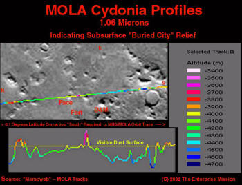
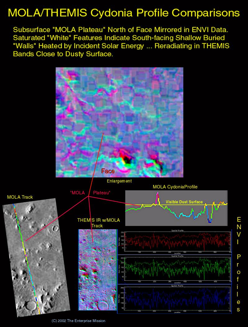
In an ironic twist, we can use published MOLA (Mars Orbiter Laser
Altimeter)
data from Mars Global Surveyor to ultimately clinch our
"buried City" model.
The laser altimetry data from
a single pass over the Face (above)
provides an excellent test of our "dust covered ice" model. The MOLA
instrument operates at the10.6 micron wavelength, essentially
smack-dab in the middle of the THEMIS sensing band. The altimeter is
not capable of penetrating solid ground at that wavelength, but it
should not have a problem piercing a "fluffy" layer of micron-sized
dust and an underlying long-wave IR translucent material … like ice.
When, in fact, we look at the altitude scan (above), we can see that
the majority of the ground truth at Cydonia (incredibly!) seems to
lie below the mean datum of the visible plain (in some areas many
thousands of feet below). In addition, there are no corresponding
visible troughs or "geologic" features to account for this anomalous
"penetration" - but there is our stunning "cityscape" ....
So what the MOLA data is exquisitely confirming is that Cydonia is
not a "flat, relatively featureless plain" - with some "mildly
eroded" mesas scattered about. It is, in fact, a deep, dust covered
plain which lies atop a thick layer of ice that has preserved and
concealed - literally for countless millennia - a once highly
advanced, plainly technological, and mysteriously now absent
civilization.
All it takes to peel back this "Truth's protective layer," is to go
there … brush away the dust … and literally start drilling ....
And there is one final point to be made here. Another reason we are
so certain that this new Cydonia data is the "real deal," and the
official version is a cruel hoax on the American people … if not the
World … is because the data from Keith's version of the IR data is
consistent with what we already know about what secrets Mars holds
under the surface.
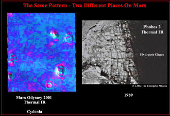
In case any of you have forgotten, this THEMIS Cydonia "city
pattern" is a virtual twin for the discovery made by a similar
"thermal IR scanner" aboard Russia's Phobos 2 spacecraft in 1989. A
side by side comparison (above) clearly demonstrates that "Cydonia
City" is NOT an isolated settlement, but rather part of what appears
to be a planet wide, far-reaching civilization ...
There can be no middle ground here. Architects and engineers will
instantly recognize the form, fit and function of their craft in the
objects scattered all throughout the THEMIS image. And even more,
some of the features can be seen, just barely covered over, in the
Odyssey visible light image … and even on the original Viking data.
How "noise" could occupy the same area and location on images taken
25 years apart, by completely different instruments, and on
completely different spacecraft … is going to be a tough hurdle for
the usual suspects to clear. In addition, the MOLA data confirms
that a great deal of Cydonia exists below the visible surface (why
didn’t the MOLA scientists back at Goddard catch this years ago …?)
- precisely in the "basin" occupied by our frozen City.
The laser can't lie.
So Keith's version of the IR image - the only one which is
consistent with all the other observations - must be the closest
thing to the "real" data returned by the THEMIS instrument we have
now in the public view (again, all this will be covered in even more
detail in Richard's document).
But there is one final point.
We are pretty sure at this point that the "official" version has a
visible light image layered over the top of the degraded
multi-spectral THEMIS image. We don't have proof positive yet, but
we are working on that.
However, there are a couple of issues that
fall out of that critical assumption.
We had hoped, based on Enterprise Principal Investigator Richard C.
Hoagland's discussion with NASA's Dr. James Garvin - the head
scientist of NASA's on-going Mars programs - to avoid the usual
"cloak and dagger" nonsense over this new data that has so permeated
and tainted our various interactions with NASA over the years.
However, we must now reluctantly conclude - based on this most
recent "bait and switch" maneuver, apparently cooked up by someone
inside ASU's official THEMIS team - that nothing’s really changed
in this regard. As we considered what might have happened, had we
gone ahead and published our results on August the 22nd, 2002, as
originally planned, it became very obvious that someone in NASA/ASU
was trying very hard -
To set us up!
Had we gone forward with our original announcement, and revealed the
images you have seen here for the first time, we would have
naturally called upon NASA professionals and experienced IR imaging
experts in the private sector and academia to replicate our work.
They would have then gone to the official THEMIS web site,
downloaded the "official" version of the THEMIS IR data … and been
totally unable to accomplish that - even given the proper
multi-spectral software and experience.
We would have been thoroughly and publicly discredited - certainly
in the eyes of the "curious middle" of this debate. And any nascent
interest in the possibility of a former, now extinct Martian
civilization - beginning to stir among some of the "honest"
professionals inside NASA (and other agency's), who have finally
begun to be suspicious that there is more to this question than has
been officially admitted by NASA over the years - would have
quietly died ….
As "someone" carefully intended.
It was a desperate gamble really, a sign of panic and disorder
behind the scenes. And it has just blown up in their Faces ....
A few of you may recall that, sometime back, we discussed our
contention that not only were the vast majority of NASA employees
"honest and open," but that among the "insiders," the ones who knew
the reality of Cydonia and the bigger questions inside the Agency,
there was a literal "war" (of sorts) going on.
We divided these two groups into the "Owls" and the "Roosters," two
terms used inside the intelligence community to refer to groups that
advocate suppression of a given issue vs. revelation of a given
issue. Based on the events of recent months, the replacement of Dan Goldin with
Sean O'Keefe, the MOC image of the Face, and the
increasing signs of cooperation from NASA (the "Garvin phone call")
for the first time in decades, we had concluded that the "Roosters,"
the whistle blowers, were "winning" this peculiar "war." We also
concluded that it was only a matter of time before the walls around
the Cydonia question came crashing down. We felt confident in this
for one essential reason -
We know their timetable.
However, this does not mean that the losers, the "Owls," will go
quietly away. And just which side is running this current
"operation" – "will the Real THEMIS image please stand up"
- is
what we are still trying to figure out ourselves.
In order to separate the good guys from the bad guys, our first
order of business was to determine just "how" and "why" Keith Laney
was apparently specifically targeted to receive this data, and just
"who" pulled the necessary strings to implement this part of the
"Grand Plan."
And, most importantly - who gave the orders!
In order to reconstruct that trail, we must go back a ways, and
necessarily, delve into the pervasive ritual pattern behind NASA's
behavior that still makes some in the anomalist community so
uncomfortable.
We can start by going back to the two main players in this little
psycho-drama, "BAMF" and "Dan Smythe."
They both showed up in the Enterprise conference area within about a
month of the release of the Cydonia IR data (actually, Smythe only
surfaced after the image was released). This was shortly after
Hoagland's seeming "breakthrough conversation" with Jim Garvin, and
before any of us had a hint that this Cydonia IR data release from
Odyssey was coming.
In retrospect, it is now obvious that this was a reconnaissance
mission, an attempt to sort out just who among our "crowd" might
have the knowledge and expertise to work with the "real" data once
it was released. Keith Laney would be an ideal candidate for this
kind of operation. He was reasonably independent of Enterprise,
worked for NASA/AMES (or "Rooster central" as we like to call it)
Marsoweb Project, and had quite a bit of experience in visual image
processing. What he lacked was any experience working with
multi-spectral data. Into this void stepped Gorelick and Smythe - as we’ve documented repeatedly above.
Once we had a "heads-up" from Stephen Saunders, the
Chief Project
Scientist for the Mars Odyssey Mission, that this data was going to
be released the week of July the 26th, we looked back to our "ritual
calendar" and tried to make a prediction as to what day it would
actually be released. Since the original nighttime IR data had been
released of Hydaspis Chaos
exactly 13 years to the day after the
taking of the Phobos 2 image of the same region, we felt very
strongly that this data release would follow a similar pattern.
Very quickly, a date jumped out at us as perfect for the completion
of this "NASA ritual."
July 25th, 1976, was a very important date, not only in the history
of this investigation, but in the annals of NASA’s record keeping.
It was on that day, at 3:26 PM GMT, that a NASA probe named Viking 1
passed over a northern plain on Mars and snapped a photograph that
would forever change the course of the space program, if not of
History itself.
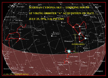
It did so, you shouldn’t be surprised to learn by now, precisely in
accordance with the now familiar "Osiris ritual" that we have
documented so many times in NASA’s 44-year history.
Immediately, we realized that in order to complete this arcane
"ritual," to stay consistent with the bizarre pattern of behavior
that we had documented over and over again, they would have to
release the new THEMIS Cydonia IR data on Thursday, July 25th, 2002,
the 31st anniversary of the taking of 35A72 - the famous first
"Face on Mars" image. No other date fit the pattern.
Imagine our surprise then, when for the first time in memory, they
broke the pattern and released the image in the early afternoon of
July 24th, 2002, not on the 25th. As we contemplated this break with
tradition, we wondered if perhaps this was a hopeful sign, and
indication that the ritualists inside NASA had – finally! - lost
control of the agenda.
We now know better.
What was released on the 24th, and what the vast majority of the
press and public downloaded, was not the "real deal" at all, NOT the
real data - but the not-so-cleverly constructed fake. Keith Laney,
almost certainly their #1 candidate to receive the "real" IR data,
took a quick look at the public release, pronounced "it sucks" and
didn't even bother to download it.
Richard Hoagland quoted Keith
that night on "Coast to Coast AM," and following that, Keith got
into get a series of pointed exchanges with both BAMF and Smythe.
Eventually, after much prodding, Keith went back to the THEMIS
website, and downloaded the image we now know is the "real" data …
on July the 25th, 2002 at 10:27 PM EDT.
So in essence, "someone" did complete the ritual: by getting the
"real data" to Keith - and thus to Enterprise, and to the American
people - on the correct ritual date, July 25th!
One other point.
We know many of you are uncomfortable with our investigation or
discussion of these types of ritualistic behaviors on the part of
NASA. We are sensitive to that, but we cannot allow it to sway us
from the truth. So we must report one other strange but consistent
"ritual observation" that Keith Laney discovered almost straight
away. When you crop and rotate the individual image strips from his
"real" source data to the vertical, and examine the pixel count
- it turns out that the image strips are 1947 pixels by 333 pixels …
down and across.
Or, 19.5 X 33, if you are tracking this sort of ritual. We thought
that was pretty cute ...
Following that, BAMF proceeded to provide enough assistance to Keith
(and Holger, among others) to enable Laney eventually to figure out
how to properly process the data he’d been given, and exactly what
software he would need to carry out the job. Bamf interlaced this
crucial private e-mail tutoring in "multi-spectral imaging" with his
previously mentioned bizarre public comments on our Enterprise
investigation, along with other categorically false assertions on
the THEMIS Cydonia data themselves.
Among these were unambiguous statements that "the IR data on the
website were useless" because they had "not been calibrated," and
that "the Face is not any different than any other object at Cydonia
… is not made of anything unusual, like metal or plastic …." Not
only are both these statements wrong - they are flat out
contradictory.
A JPL paper on decorrelation stretch techniques (Algorithm
Theoretical Basis Document for Decorrelation Stretch, version 2.2,
August 15th, 1996, Ronald E. Alley Jet Propulsion Laboratory, 4800
Oak Grove Drive, Pasedena CA. 91109.) states flatly that calibration
is not necessary to make use of decorrelation stretched IR data,
because of the nature of the algorithm and the quality of the
process itself.
All calibration ultimately does is identify which
colors relate to which materials - assuming you know what materials
you are dealing with in a totally alien context the first place.
There is, obviously, some question on that matter raised by this
particular Cydonia data.
And as for Gorelick declaring that "he knew what the Face is
composed of," after he already claimed that the data "wasn't
calibrated," this simply made no sense. Forgetting that it conflicts
with not only the image caption that he (presumably) posted, it also
conflicts with Christensen's email in which he (Christensen)
restates that the data is "calibrated." So for Gorelick to presume
he knows what the Face is made of, when by his own claim he is
working with uncalibrated data, was and is "pure poppycock."
And even if the data is calibrated, as the THEMIS web site and his
boss now claim, he still can't possibly know what the Face or
anything else is made of down there … because right now, nobody
knows what "Cydonia City" is composed of ... there being literally
NO "spectral library" on alien construction methods and materials ….
All of these conflicting signals left us with a few certainties, and
many more unanswered questions. We knew Keith's dataset was valid,
and we knew that Gorelick had tried to help us "to some degree." We
also knew that "somebody" was hoping to sucker punch us - by
changing the data on the official site, in order to create profound
confusion when we tried to have our own analysis verified by
reference to that "official" data set.
So this left us with two questions: just who were the "good guys"
and "bad guys" inside the ASU THEMIS team; and, how did they get the
right data to Keith Laney - and only Keith - for their "ritually
perfect" July 25th ritualistic window?
What then became clear was that the answer to one question should
provide the answer to the other.
Exactly how had Keith been targeted? And, how come, nobody else
(apparently) got the same image … on the same anniversary date?
Suddenly, the answer to that crucial question became very, very
clear … very, very quickly.
Keith Laney has a cable modem connection to the Internet. What that
means is that he has a "static" IP address. Every time he goes
online (or even has his computer turned on and physically connected
to the Web), he broadcasts the same identifier to the whole world.
It would certainly be a piece of cake for any reasonably savvy
computer network expert to "ping" Keith's system, determine his
static IP address, and lay a "trap" for him .…
Once "they" had convinced Keith to go back (on the 25th) and finally
download the THEMIS Cydonia image, it would be a fairly easy process
to simply wait for his IP address to "log-in" to the official THEMIS
website, and then redirect him - and only him - to a duplicate
website … that looked exactly like the official THEMIS page, but
which instead contained the "real" data Keith now has on his
computer.
But, how do we know that this was done? How can we be so sure he was
"set up" in this precise pre-calculated manner?
For one thing, although it now appears that a couple of other people
may have obtained a version of the "real" IR data similar to Keith's
(which reinforces the bizarre aspect of official data constantly
changing on a supposedly unchanging website) - none of them
obtained it on July 25th. So far as we can determine, only Keith
Laney got the "real stuff" on that key date.
But the second, and most important reason we know this was done, is
because this exact process - the act of redirecting someone to a
different server or webpage, with or without their knowledge - has
a specific name amongst the world’s computer geeks. In the jargon of
the techno-savvy, of which Noel Gorelick is undeniably a world-class
member, it's called simply ...
Bamfing ...!
So what Gorelick was doing all along - in his months-long "away
mission to the alien land of Enterprise" - was apparently seeking
out the just right person to leak this crucial IR data to … finding
the perfect character to "Bamf" the real, stunning Cydonia images.
So just who are Gorelick and Christensen, anyway? Heros … or
villains? Friend or foe? Both … or neither?
We honestly still don't really know.
It could be that they worked together to help set us up, or it could
be that Gorelick leaked the real data to Laney because he was tired
of all the cover-ups and nonsense behind the scenes. Or, it could be
that both men were pressured, put upon by a powerful outside "Owl"
element, to participate in this continuing fraud perpetrated on the
American people and the World.
Unfortunately, we tend to think that this latter scenario is the
more probable at this point.
Do not forget that "Deep Space," our inside Administration source
(who, in turn, is fronting for a host of other sources …), told us
weeks ago that "the lawyers are running everything at this point"
inside NASA, in response to our own continuing political and legal
initiatives. This sort of smarmy trick, this kind of underhanded
double dealing on this key new Cydonia data, is exactly the way some
such individuals tend to think and operate.
Especially, when they’re desperate.
Certainly, anyone who has worked with the real "new data" over the
last month can see this war is about over.
The reality of Cydonia's artificiality is a train that has already
left the station, an inevitability that must increasingly be Faced.
As we have repeatedly pointed out, the real battle is no longer
about the reality of the Monuments of Mars - that battle was won a
long time ago - but over who gets to define the meaning of those
extraordinary monuments. It is that battle which is now crucial and
obviously in full force - as is our ability to do that which
strikes fear into the heart of the "Owl's" who have worked so hard
to conceal the Truth about Cydonia and Mars … for so damn long.
If they could get the data out, become "a little bit pregnant" and
at the same time manage to marginalize the Enterprise Mission, they
win all the way around. But they have failed in this desperate
gambit. We have once more swept aside another clumsy assault on our
scientific and political credibility.
Our enemies will now go even further, and probably claim that we
somehow "fabricated" the data we have now presented to the world.
But what else can they say? The important point to remember is that
"we," as in the Enterprise Mission, have not presented this data at
all.
If you are going to accuse someone of not telling the truth, of
fabricating the "real" data here, then you must accuse Keith Laney
of the NASA/AMES Marsoweb Program, NOT "Richard Hoagland," "Mike Bara," or anyone else associated with Enterprise itself!
We literally had NO HAND in obtaining this source data. We simply
recognize what we are seeing in its stunning evidence ….
And again, we must ask you to consider just which side has more
credibility here. The side that perpetrated
the "Catbox" fraud upon
the world, and followed that with
the MOLA fraud … or the side which
has now exposed yet
another attempted duplicitous deception on the
part of NASA, with the Mars Odyssey 2001 THEMIS IR data?
We also understand that in an 11th hour move, NASA/ASU is now
putting out multiple versions of the "real" data - in an obvious
effort to hide it amongst the "noise" that will be subsequently
generated. Obviously, they are trying to flood the market with so
many differing versions (Deep Space had told us there are now 20),
that they hope to create so much doubt about the integrity of the
"real" source data that the majority will ultimately have to declare
that "no dataset can be counted on as real."
Too bad they didn't think to check the MOLA data first.
So, we must focus solely on the real THEMIS data itself, on its
extraordinary internal consistency and scientific testimony … and on
the proof that we now have. To this end, we will not even consider
working with anything other than the data that Keith first obtained
on the 25th of July, 2002. All other datasets must now be considered
suspect, because they have all popped up subsequent to our public
exposure (on "Coast to Coast." August 29th) of the fraud perpetrated
by NASA/ASU one month earlier.
What is now abundantly clear is that the system inside NASA/JPL/ASU
is so poisoned with corruption that nothing short of complete
oversight and entirely new standards of accountability can be
contemplated as a solution to this problem. Until that happens, no
one inside the THEMIS team had better so much as lose their parking
place as a consequence of all of this.
It is now more imperative than ever that nighttime IR images of, not
just Cydonia - but every Odyssey image taken so far of the entire
planet - be released without delay. Any new data acquisitions must
be monitored by outside sources, and full accountability must be
demanded of the paper trail for each and every image.
We can only do this with your help.
As Richard C. Hoagland will call for tonight, we must now take this
issue without delay to the Congress, to our President, and to our
last real hope for Freedom ... the media itself. We finally have the
proof of what is down there at Cydonia. What we must now do is to
collectively - together - twist the arms of "the bad guys" … until
they publicly admit that Truth.
When the lights come on, the cockroaches inevitably scatter.
Ironically, "Cydonia" derives from a Greek root, meaning
"enlightenment." Or, in this context "to illuminate the True History
of All Mankind."
It is our intent – with the help of the American people, and our
loyal "crew" here - to shine Cydonia’s light of Truth intensely on
the THEMIS team, regarding the wonders that await us all beneath the
dusty Cydonia plains … as it has never shone before. And on those
still hiding in the dark … still attempting - with their last
minute, desperate efforts - to manipulate us all.
OK guys, Cydonia – the Light – is coming. Time to start scattering
.…
More Mars Odyssey
2001 Cydonia Infrared Images
|