|
5 - GAIA: THE CLEAVED
PLANET
Why do we call our planet “Earth”?
In German it is Erde, from Erda in Old High German; Jordh in
Icelandic, Jord in Danish. Erthe in Middle English, Airtha in
Gothic; and going eastward geographically and backward in time,
Ereds or Aratha in Aramaic, Erd or Ertz in Kurdish,
Eretz in Hebrew.
The sea we nowadays call the Arabian Sea, the body of water that
leads to the Persian Gulf, was called in antiquity the Sea of Erythrea; and to this day,
ordu means an encampment or settlement in
Persian. Why? The answer lies in the Sumerian texts that relate the
arrival of the first group of Anunnaki/Nefilim on Earth. There were
fifty of them, under the leadership of E.A (“Whose Home is Water”),
a great scientist and the Firstborn son of the ruler of Nibiru, ANU.
They splashed down in the Arabian Sea and waded ashore to the edge
of the marshlands that, after the climate warmed up, became the
Persian Gulf (Fig. 32). And at the head of the marshlands they
established their first settlement on a new planet; it was called by
them E.RI.DU—“Home In the Faraway”—a most appropriate name. And so it was that in
time the whole settled planet came to be called after that first
settlement—Erde, Erthe, Earth. To this day, whenever we call our
planet by its name, we invoke the memory of that first settlement on
Earth; unknowingly, we remember Eridu and honor the first group of
Anunnaki who established it.
The Sumerian scientific or technical term for Earth’s globe
and its firm surface was KI. Pictographically it was represented
as a somewhat flattened orb (Fig. 33a) crossed by vertical lines
not unlike modern depictions of meridians (Fig. 33b). Since
Earth does indeed bulge somewhat at its equator, the Sumerian
representation is more correct scientifically than the usual modern
way of depicting Earth as a perfect globe...
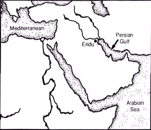
Figure 32

Figure 33
After Ea had
completed the establishment of the first five of the seven original
settlements of
the Anunnaki, he was given the title/epithet
EN.KI,
“Lord of Earth.” But the term KI, as a root or verb, was applied to
the planet called “Earth” for a reason. It conveyed the meaning “to
cut off, to sever, to hollow out.” Its derivatives illustrate the
concept: KI.LA meant “excavation,” KI.MAH “tomb,” KI.IN.DAR
“crevice, fissure.” In Sumerian astronomical texts the term KI was
prefixed with the determinative MUL (“celestial body”). And thus
when they spoke of mul.KI, they conveyed the meaning, “the celestial
body that had been cleaved apart.”
By calling Earth KI, the Sumerians thus invoked their cosmogony—the
tale of the Celestial Battle and the cleaving of Tiamat.
Unaware of its origin we continue to apply this descriptive epithet
to our planet to this very day. The intriguing fact is that over
time (the Sumerian civilization was two thousand years old by the
time Babylon arose) the pronunciation of the term ki changed to
gi,
or sometimes ge. It was so carried into the Akkadian and its
linguistic branches (Babylonian, Assyrian, Hebrew), at all times
retaining its geographic or topographic connotation as a cleavage, a
ravine, a deep valley.
Thus the biblical term that through Greek
translations of the Bible is read Gehenna stems from the Hebrew
Gai-Hinnom, the crevice-like narrow ravine outside Jerusalem named
after Hinnom, where divine retribution shall befall the sinners via
an erupting subterranean fire on Judgment Day. We have been taught
in school that the component geo in all the scientific terms applied
to Earth sciences—geo-graphy, geo-metry, geo-logy, and so on—comes
from the Greek Gaia (or Gaea), their name for the goddess of Earth.
We were not taught where the Greeks picked up this term or what its
real meaning was. The answer is, from the Sumerian KI or GI.
Scholars agree that the Greek notions of primordial events
and of the gods were borrowed from the Near East, through
Asia Minor (at whose western edge early Greek settlements
like Troy were located) and via the island of Crete in the eastern
Mediterranean. According to Greek tradition Zeus, who was
the chief god of the twelve Olympians, arrived on the Greek mainland
via Crete, whence he had fled after abducting the beautiful Europa,
daughter of the Phoenician king of Tyre.

Figure 34
Aphrodite arrived from the
Near East via the island of Cyprus. Poseidon (whom the Romans called
Neptune) came on horseback via Asia Minor, and Athena brought the
olive to Greece from the lands of the Bible. There is no doubt that
the Greek alphabet developed from a Near Eastern one (Fig. 34).
Cyrus H. Gordon (Forgotten Scripts: Evidence
for the Minoan Language and other works) deciphered the enigmatic
Cretan script known as Linear A by showing that it represented a
Semitic, Near Eastern language. With the Near Eastern gods and the
terminology came also the “myths” and legends.
The earliest Greek
writings concerning antiquity and the affairs of gods and men were
the Iliad, by Homer; the Odes of Pindar of Thebes; and above all the
Theogony (“Divine Genealogy”) by Hesiod, who composed this work and
another (Works and Days).
In the eighth century B.C., Hesiod began
the divine tale of events that ultimately led to the supremacy of
Zeus—a story of passions, rivalries, and struggles covered in The
Wars of Gods and Men, third book of my series The Earth
Chronicles—and the creation of the celestial gods, of Heaven and
Earth out of Chaos, a tale not unlike the biblical Beginning:
Verily, at first Chaos came to be,
and next the wide-bosomed Gaia—
she who created all the immortal ones
who hold the peaks of snowy Olympus:
Dim Tartarus, wide-pathed in the depths,
and Eros, fairest among the divine immortals. . . .
From Chaos came forth Erebus and black Nyx;
And of Nyx were born Aether and Hemera.
At this point in the process
of the formation of the “divine immortals”—the celestial
gods—“Heaven” does not yet exist, just as the Mesopotamian sources
recounted. Accordingly, the “Gaia” of these verses is the equivalent
of Tiamat, “she who bore them all” according to the Enuma elish.
Hesiod lists the celestial gods who followed “Chaos” and “Gaia” in
three pairs (Tartarus and Eros, Erebus and Nyx, Aether and Hemera).
The parallel with the creation of the three pairs in Sumerian
cosmogony (nowadays named Venus and Mars, Saturn and Jupiter, Uranus
and Neptune) should be obvious (though this comparability seems to
have gone unnoticed).
Only after the creation of the principal
planets that made up the Solar System when Nibiru appeared to invade
it does the tale by Hesiod—as in the Mesopotamian and biblical
texts—speak of the creation of Ouranos, “Heaven.” As explained in
the Book of Genesis, this Shama’im was
the Hammered-Out-Bracelet, the asteroid belt. As related in the Enuma elish,
this was the half of Tiamat that was smashed to pieces,
while the other, intact half became Earth. All this is echoed in the
ensuing verses of Hesiod’s Theogony:
And Gaia then bore starry Ouranos
—equal to herself—
to envelop her on every side,
to be an everlasting abode place for
the gods.
Equally split up.
Gaia ceased to be Tiamat.
Severed from
the smashed-up half that became the Firmament, everlasting abode of
the asteroids and comets, the intact half (thrust into another
orbit) became Gaia, the Earth. And so did this planet, first as Tiamat and then as Earth, live up to its epithets: Gaia, Gi, Ki—the
Cleaved One.
How did the Cleaved Planet look in the aftermath of the Celestial
Battle, now orbiting as Gaia/ Earth? On one side there were the firm
lands that had formed the crust of Tiamat; on the other side there
was a hollow, an immense cleft into which the waters of the
erstwhile Tiamat must have poured.
As Hesiod put it, Gaia (now
the half equivalent to Heaven) on one side “brought forth long hills,
graceful haunts of the goddess-Nymphs”; and on the other side “she
bare Pontus, the fruitless deep with its raging swell.’”
This is the same picture of the cleaved planet provided by the Book
of Genesis:
And Elohim said,
“Let the waters under the heaven
be gathered together into one place,
and let the dry land appear.”
And it was so.
And Elohim called the dry land “Earth,”
and the gathered-together water He called “Seas.”
Earth, the new Gaia, was taking shape.
Three thousand years separated Hesiod from the time when
the
Sumerian civilization had blossomed out; and it is clear that throughout those millennia ancient peoples, including
the authors or compilers of the Book of Genesis, accepted the
Sumerian cosmogony. Called nowadays “myth,” “legend,” or “religious
beliefs,” in those previous millennia it was science—knowledge, the
Sumerians asserted, bestowed by the Anunnaki.
According to that ancient knowledge, Earth was not an original
member of the Solar System. It was the cleaved-off half of a planet
then called Tiamat, “she who bore them all.” The Celestial Battle
that led to the creation of Earth occurred several hundred million
years after the Solar System with its planets had been created.
Earth, as a part of Tiamat, retained much of the water that Tiamat,
“the watery monster,” was known for. As Earth evolved into an
independent planet and attained the shape of a globe dictated by the
forces of gravity, the waters were gathered into the immense cavity
on the torn-off side, and dry land appeared on the other side of the
planet This, in summary, is what the ancient peoples firmly
believed. What does modern science have to say?
The theories concerning planetary formation hold that they started
as balls congealing from the gaseous disk extending from the Sun. As
they cooled, heavier matter—iron, in Earth’s case—sank into their
centers, forming a solid inner core. A less solid, plastic, or even
fluid outer core surrounded the inner one; in Earth’s case, it is
believed to consist of molten iron. The two cores and their motions
act as a dynamo, producing the planet’s magnetic field. Surrounding
the solid and fluid cores is a mantle made of rocks and minerals; on
Earth it is estimated to be some 1,800 miles thick. While the
fluidity and heat generated at the planet’s core (some 12,000
degrees Fahrenheit in the Earth’s center) affect the mantle and what
is on top of it, it is the uppermost 400 miles or so of the mantle
(on Earth) that mostly account for what we see on the surface of the
planet—its cooled crust.
The processes that produce, over billions of years, a spherical
orb—the uniform force of gravity and the planet’s rotation
around its axis—should also result in an orderly layering. The
solid inner core, the flexible or fluid outer core, the thick lower
mantle of silicates, the upper mantle of rocks, and the uppermost
crust should encompass one another in ordered layers,
like the skin of an onion. This holds true for the orb called Earth
(Fig. 35)—but only up to a point; the main abnormalities concern
Earth’s uppermost layer, the crust.

Figure 35
Ever since the extensive probes of the Moon and Mars in the 1960s
and 1970s, geophysicists have been puzzled by the paucity of the
Earth’s crust. The crusts of the Moon and of Mars comprise 10
percent of their masses, but the Earth’s crust comprises less than
one half of 1 percent of the Earth’s landmass. In 1988,
geophysicists from Caltech and the University of Illinois at Urbana,
led by Don Anderson, reported to the American Geological Society
meeting in Denver, Colorado, that they had found the “missing
crust.” By analyzing shock waves from earthquakes, they concluded
that material that belongs in the crust has sunk down and lies some
250 miles below the Earth’s surface. There is enough crustal
material there, these scientists estimated, to increase the
thickness of the Earth’s crust tenfold.
But even so, it would have
given Earth a crust comprising no more than about 4 percent of its
landmass—still only about half of what seems to be the norm (judging
by the Moon and Mars); half of the Earth’s crust will still be missing even if the findings by this group prove
correct. The theory also leaves unanswered the question of what
force caused the crustal material, which is lighter than the
mantle’s material, to “dive”—in the words of the report—hundreds of
miles into the Earth’s interior. The team’s suggestion was that the
crustal material down there consists of “huge slabs of crust” that
“dived into the Earth’s interior” where fissures exist in the crust.
But what force had broken up the crust into such “huge slabs”?

Figure 36
Another abnormality of the Earth’s crust is that it is not uniform.
In the parts we call “continents,” its thickness varies from about
12 miles to almost 45 miles; but in the parts taken up by the oceans
the crust is only 3.5 to five miles thick. While the average
elevation of the continents is about 2,300 feet, the average depth
of the oceans is more than 12,500 feet. The combined result of these
factors is that the much thicker continental crust reaches much
farther down into the mantle, whereas the oceanic crust is just a
thin layer of solidified material and sediments (Fig. 36).
There are other differences between the Earth’s crust where the
continents are and where the oceans are. The composition of the continental crust, consisting in large part
of rocks resembling granite, is relatively light in comparison with
the composition of the mantle: the average continental density is
2.7-2.8 grams per cubic centimeter, while that of the mantle is 3.3
grams per cubic centimeter. The oceanic crust is heavier and denser
than the continental crust, averaging a density of 3.0 to 3.1 grams
per cubic centimeter; it is thus more akin to the mantle, with its
composition of basaltic and other dense rocks, than to the
continental crust. It is noteworthy that the “missing crust” the
scientific team mentioned above suggested had dived into the mantle
is similar in composition to the oceanic crust, not to the
continental crust.
This leads to one more important difference between the Earth’s
continental and oceanic crusts. The continental part of the crust is
not only lighter and thicker, it is also much older than the oceanic
part of the crust. By the end of the 1970s the consensus among
scientists was that the greater part of today’s continental surface
was formed some 2.8 billion years ago. Evidence of a continental
crust from that time that was about as thick as today’s is found in
all the continents in what geologists term Archean Shield areas; but
within those areas, crustal rocks were discovered that turned out to
be 3.8 billion years old. In 1983, however, geologists of the
Australian National University found, in western Australia, rock
remains of a continental crust whose age was established to be 4.1
to 4.2 billion years old.
In 1989, tests with new, sophisticated
methods on rock samples collected a few years earlier in northern
Canada (by researchers from Washington University in St. Louis and
from the Geological Survey of Canada) determined the rocks’ age to
be 3.96 billion years; Samuel Bowering of Washington University
reported evidence that nearby rocks in the area were as much as 4.1
billion years old. Scientists are still hard put to explain the gap
of about 500 million years between the age of the Earth (which
meteor fragments, such as those found at Meteor Crater in Arizona,
show to be 4.6 billion years) and the age of the oldest rocks thus
far found; but no matter what the explanation, the fact that Earth
had its continental crust at least 4 billion years ago is by now
undisputed. On the other hand, no part of the oceanic crust has been
found to be more than 200 million years old.
This is a tremendous difference that no amount of speculation about
rising and sinking continents, forming and vanishing seas can
explain. Someone has compared the Earth’s crust to the skin of an
apple. Where the oceans are, the “skin” is fresh—relatively
speaking, born yesterday. Where the oceans began in primordial
times, the “skin,” and a good part of the “apple” itself, appear to
have been shorn off.
The differences between the continental and oceanic crusts must have
been even greater in earlier times, because the continental crust is
constantly eroded by the forces of nature, and a good deal of the
eroded solids are carried into the oceanic basins, increasing the
thickness of the oceanic crust. Furthermore, the oceanic crust is
constantly enhanced by the upwelling of molten basaltic rocks and
silicates that flow up from the mantle through faults in the sea
floor. This process, which puts down ever-new layers of oceanic
crust, has been going on for 200 million years, giving the oceanic
crust its present form. What was there at the bottom of the seas
before then? Was there no crust at all, just a gaping “wound” in the
Earth’s surface? And is the ongoing oceanic crust formation akin to
the process of blood clotting, where the skin is pierced and
wounded?
Is Gaia—a living planet—trying to heal her wounds? The most obvious
place on the surface of the Earth where it was so “wounded” is the
Pacific Ocean. While the average plunge in the crust’s surface in
its oceanic parts is about 2.5 miles, in the Pacific the crust has
been gouged out to a present depth reaching at some points 7 miles.
If we could remove from the Pacific’s floor the crust built up there
over the last 200 million years, we would arrive at depths reaching
12 miles below the water’s surface and between some 20 to nearly 60
miles below the continental surface. This is quite a cavity...
How deep was it before the crustal buildup over the past 200 million
years—how large was the “wound” 500 million years ago, a billion
years ago, 4 billion years ago? No one can even guess, except to say
that it was substantially deeper.
What can be said with certainty is
that the extent of the gouging was more extensive, affecting a
vastly greater part of the planet’s surface. The Pacific Ocean at
present occupies about a third of Earth’s surface; but (as far as
can be ascertained for the past 200 million years) it has been
shrinking. The reason for the shrinkage
is that the continents flanking it—the Americas on the east, Asia
and Australia on the west—are moving closer to each other, squeezing
out the Pacific slowly but relentlessly, reducing its size inch by
inch year by year.
The science and explanations dealing with this process have come to
be known as the Theory of Plate Tectonics. Its origin lies, as in
the study of the Solar System, in the discarding of notions of a
uniform, stable, permanent condition of the planets in favor of the
recognition of catastrophism, change, and even evolution—concerning
not only flora and fauna but the globes on which they evolved as
“living” entities that can grow and shrink, prosper and suffer, even
be born and die. The new science of plate tectonics, it is now
generally recognized, owes its beginning to Alfred Wegener, a German
meteorologist, and his book Die Entstehung der Kontinente und Ozeane,
published in 1915.
As it was for others before him, his starting
point was the obvious “fit” between the contours of the continents
on both sides of the southern Atlantic. But before Wegener’s ideas,
the solution had been to postulate the disappearance, by sinking, of
continents or land bridges: the belief that the continents have been
where they are from time immemorial, but that a midsection sank
below sea level, giving the appearance of continental separation.
Augmenting available data on flora and fauna with considerable
geological “matches” between the two sides of the Atlantic, Wegener
came up with the notion of
Pangaea—a supercontinent, a single huge
landmass into which he could fit all the present continental masses
like pieces in a jigsaw puzzle. Pangaea, which covered about one
half of the globe, Wegener suggested, was surrounded by the primeval
Pacific Ocean.
Floating in the midst of the waters like an ice floe,
the single landmass underwent a series of liftings and healings
until a definite and final breakup in the Mesozoic Era, the
geological period that lasted from 225 to 65 million years ago.
Gradually the pieces began to drift apart. Antarctica, Australia,
India, and Africa began to break away and separate (Fig. 37a).
Subsequently, Africa and South America split apart (Fig. 37b) as
North America began to move away from Europe and India was thrust
toward Asia (Fig. 37c); and so the continents continued to drift
until they rearranged themselves in the pattern we know today (Fig.
37d).
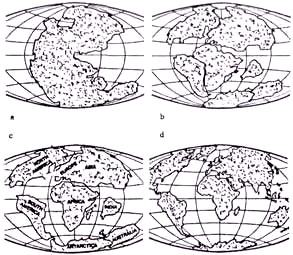
Figure 37
The split-up of Pangaea into several separate continents was
accompanied by the opening up and closing down of bodies of water
between the separating pieces of the landmass. In time the single
“Panocean” (if I may be allowed to coin a term) also separated into
a series of connecting oceans or enclosed seas (such as the
Mediterranean, Black, and Caspian seas), and such major bodies of
water as the Atlantic and the Indian oceans took shape. But all
these bodies of water were “pieces” of the original “Panocean,” of
which the Pacific Ocean still remains.
Wegener’s view of the continents as “pieces of a cracked ice floe”
shifting atop an impermanent surface of the Earth was mostly
received with disdain, even ridicule, by the geologists and
paleontologists of the time. It took half a century for the idea of
Continental Drift to be accepted into the halls of science. What
helped bring about the changed attitude were surveys of the ocean
floors begun in the 1960s that revealed such features as the
Mid-Atlantic Ridge that, it was surmised, was formed by the rise of
molten rock (called “magma”) from the
Earth’s interior. Welling up, in the case of the Atlantic, through a
fissure in the ocean floor that runs almost the whole ocean’s
length, the magma cooled and formed a ridge of basaltic rock.
But
then as one welling up followed another, the old sides of the ridge
were pushed to either side to make way for the new magma flow. A
major advance in these studies of the ocean floors took place with
the aid of Seasat, an oceanographic satellite launched in June 1978
that orbited the Earth for three months; its data were used to map
the sea floors, giving us an entirely new understanding of our
oceans, with their ridges, rifts, seamounts, underwater volcanoes,
and fracture zones. The discovery that as each upwelling of magma
cooled and solidified it retained the magnetic direction of its
position at that time was followed by the determination that a
series of such magnetic lines, almost parallel to one another,
provided a time scale as well as a directional map for the ongoing
expansion of the ocean’s floor.
This expansion of the sea floor in
the Atlantic was a major factor in pushing apart Africa and South
America and in the creation of the Atlantic Ocean (and its
continuing widening).
Other forces, such as the gravitational pull of the Moon, the
Earth’s rotation, and even movements of the underlying mantle, also
are believed to act to split up the continental crust and shift the
continents about. These forces also exert their influence,
naturally, in the Pacific region. The Pacific Ocean revealed even
more midocean ridges, fissures, underwater volcanoes, and other
features like those that have worked to expand the Atlantic Ocean.
Why, then, as all the evidence shows, have the landmasses flanking
the Pacific not moved apart (as the continents flanking the Atlantic
have done) but rather keep moving closer, slowly but surely,
constantly reducing the size of the Pacific Ocean?
The explanation is found in a companion theory of continental drift,
the Theory of Plate Tectonics. The continents, it has been
postulated, rest upon giant movable “plates” of the Earth’s crust,
and so do the oceans. When the continents drift, when oceans expand
(as the Atlantic) or contract (as the Pacific), the underlying cause
is the movement of the plates on which they ride. At present
scientists recognize six major plates (some of which are further
subdivided): the Pacific, American, Eurasian, African,
Indo-Australian, and Antarctic (Fig. 38).
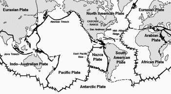
Figure 38
The spreading seafloor of the Atlantic Ocean is still distancing the
Americas from Europe and Africa, inch by inch. The concomitant
shrinking of the Pacific Ocean is now recognized to be accommodated
by the dipping, or “subduction,” of the Pacific plate under the
American plate. This is the primary cause of the crustal shifts and
earthquakes all along the Pacific rim, as well as of the rise of the
major mountain chains along that rim. The collision of the Indian
plate with the Eurasian one created the Himalayas and fused the
Indian subcontinent to Asia. In 1985, Cornell University scientists
discovered the “geological suture” where a part of the western
African plate remained attached to the American plate when the two
broke apart some fifty million years ago, “donating” Florida and
southern Georgia to North America.
With some modifications, almost all scientists today accept
Wegener’s hypothesis of an Earth initially consisting of a single
landmass surrounded by an all-embracing ocean. Notwithstanding
(geologically) the young age (200 million years) of the present
seafloor, scholars recognize that there had been a primeval ocean on
Earth whose traces can be found not in the newly covered depths of
the oceans but on the continents. The Archean Shield zones, where
the youngest rocks are 2.8 billion years old, contain belts of two
kinds: one of greenstone, another of granite-gneiss.
Writing in
Scientific American of March, 1977, Stephen Moorbath (The Oldest
Rocks and the Growth of Continents) reported that geologists
“believe that the greenstone belt rocks
were deposited in a primitive oceanic environment and in effect
represent ancient oceans, and that the granite-gneiss terrains may
be remnants of ancient oceans.” Extensive rock records in virtually
all the continents indicate that they were contiguous to oceans of
water for more than three billion years; in some places, such as
Zimbabwe in southern Africa, sedimentary rocks show that they
accreted within large bodies of water some 3.5 billion years ago.
And recent advances in scientific dating have extended the age of
the Archean belts—those that include rocks that had been deposited
in primeval oceans—back to 3.8 billion years (Scientific American,
September, 1983; special issue: “The Dynamic Earth”).
How long has continental drift been going on? Was there a Pangaea?
Stephen Moorbath, in the above-mentioned study, offered the
conclusion that the process of continental breakup began some 600
million years ago: “Before that there may have been just the one
immense supercontinent known as Pangaea, or possibly two
supercontinents: Laurasia to the north and Gondwanaland to the
south.” Other scientists, using computer simulations, suggest that
550 million years ago the landmasses that eventually formed Pangaea
or its two connected parts were no less separate than they are
today, that plate-tectonic processes of one kind or another have
been going on since at least about four billion years ago.
But
whether the mass of dry land was first a single supercontinent or
separate landmasses that then joined, whether a superocean
surrounded a single mass of dry land or bodies of water first
stretched between several dry lands, is, in the words of Moorbath,
like the chicken-and the-egg argument: “Which came first, the
continents or the oceans?”
Modern science thus confirms the scientific notions that were
expressed in the ancient texts, but it cannot see far enough back to
resolve the land mass/ocean sequence. If every modern scientific
discovery seems to have corroborated this or that aspect of ancient
knowledge, why not also accept the ancient answer in this instance:
that the waters covered the face of the Earth and—on the third
“day,” or phase—were “gathered into” one side of the Earth to reveal
the dry land. Was the uncovered dry land made
up of isolated continents or one supercontinent, a Pangaea?
Although
it really matters not as far as the corroboration of ancient
knowledge is concerned, it is interesting to note that Greek notions
of Earth, although they led to a belief that the Earth was disk-like
rather than a globe, envisioned it as a landmass with a solid
foundation surrounded by waters. This notion must have drawn on
earlier and more accurate knowledge, as most of Greek science did.
We find that the Old Testament repeatedly referred to the
“foundations” of Earth and expressed knowledge of the earlier times
regarding the shape of Earth in the following verses praising the
Creator:
The Lord’s is the Earth and its entirety,
the world and all that dwells therein.
For He hath founded it upon the seas
and established it upon the waters.
(Psalms 24:1-2)
In addition to the term Eretz which means both planet “Earth” and
“earth, ground.” the narrative in Genesis employs the term
Yabashah—literally, “the dried-out landmass”—when it states that the
waters “were gathered together into one place” to let the Yabashah
appear. But throughout the Old Testament another term, Tebel, is
frequently used to denote that part of Earth that is habitable,
arable, and useful to Mankind (including being a source of ores).
The term Tebel—usually translated as either “the earth” or “the
world”—is mostly employed to indicate the part of Earth distinct
from its watery portions; the “foundations” of this Tebel were in
juxtaposition to the sea basins. This was best expressed in the Song
of David (2 Samuel 22:16 and Psalms 18:16):
The Lord thundered from the heavens,
the Most High his sounds uttered.
He loosed his arrows, sped them far and wide;
a shaft of lightning,
and disconcerted them.
The channels of the seabed were revealed,
the foundation of Tebel were laid bare.
With what we know today about the “foundations of the Earth,” the
word Tebel clearly conveys the concept of continents whose foundations—tectonic plates—are
laid in the midst of the waters. What a thrill to discover the
latest geophysical theories echoed in a 3,000-year-old psalm!
The Genesis narrative states clearly that the waters were “gathered
together” to one side of the Earth so that the dry land could
emerge; this implies the existence of a cavity into which the waters
could be gathered. Such a cavity, somewhat over half the Earth’s
surface, is still there, shrunken and reduced, in the shape of the
Pacific Ocean.
Why is the crustal evidence that can be found not older than about 4
billion years, rather than the 4.6 billion years that is the
presumed age of the Earth and of the Solar System? The first
Conference on the Origins of Life, held in Princeton, New Jersey, in
1967, under the sponsorship of NASA and the Smithsonian Institution,
dwelt at length on this problem.
The only hypothesis the learned
participants could come up with was that, at the time the oldest
rock specimens that have been found were formed, Earth was subjected
to a “cataclysm.” In the discussion of the origins of Earth’s
atmosphere, the consensus was that it did not result from a
“continuous outgassing” through volcanic activity but was (in the
words of Raymond Siever of Harvard University) the result of “a
rather early and rather large outgassing episode... a great big
belch of the gases that are now characteristic of the Earth’s
atmosphere and sediments.” This “big belch” was also dated to the
same time as the catastrophe recorded by the rocks.
It thus becomes evident that in its specifics—the breakup of the
Earth’s crust, the process of plate tectonics, the differences
between the continental and the oceanic crusts, the emergence of a
Pangaea from under the waters, the primordial encircling ocean—the
findings of modern science have corroborated the ancient knowledge.
They have also led scientists from all disciplines to conclude that
the only explanation of the way in which Earth’s landmasses, oceans,
and atmosphere have evolved is to assume a cataclysm occurring about
four billion years ago—about half a billion years after the initial
formation of Earth as part of the Solar System.
What was that cataclysm? Mankind has possessed the Sumerian answer
for six thousand years: the Celestial Battle between Nibiru/Marduk
and Tiamat.
In that Sumerian cosmogony, the members of the Solar System were depicted as celestial gods, male and female,
whose creation was compared to birth, whose existence was that of
living creatures. In the Enuma elish text, Tiamat in particular was
described as a female, a mother who gave birth to a host of eleven
satellites, her “horde,” led by Kingu “whom she elevated.”
As Nibiru/Marduk and his horde neared her, “in fury Tiamat cried out
aloud, her legs shook to their roots . . . against her attacker she
repeatedly cast a spell.” When the “Lord spread his net to enmesh
her” and “the Evil Wind, which followed behind, he let loose in her
face, Tiamat opened her mouth to consume it”; but then other “winds”
of Nibiru/ Marduk “charged her belly” and “distended her body.”
Indeed, “go and cut off the life of Tiamat” was the order given by
the outer planets to the Invader; he accomplished that by “cutting
through her insides, splitting her heart. . . . Having thus subdued
her, he extinguished her life.”
For a long time this view of the
planets, and especially of Tiamat, as living entities that could be
born and could die has been dismissed as primitive paganism. But the
exploration of the planetary system in recent decades has, in fact,
revealed worlds for which the word “alive” has been repeatedly used.
That Earth itself is a living planet was forcefully put forth as
the
Gaia Hypothesis by James E. Lovelock in the 1970s (Gaia—A New Look
at Life on Earth) and was most recently reinforced by him in The
Ages of Gaia: A Biography of Our Living Earth.
It is a hypothesis
that views the Earth and the life that has evolved upon it as a
single organism; Earth is not just an inanimate globe upon which
there is life; it is a coherent if complex body that is itself alive
through its mass and land surface, its oceans and atmosphere, and
through the flora and fauna which it sustains and which in turn
sustain Earth.
“The largest living creature on Earth.”
Lovelock
wrote, “is the Earth itself.” And in that, he admitted, he was
revisiting the ancient “concept of Mother Earth, or as the Greeks
called her long ago, Gaia.”
But in fact he had gone back to Sumerian times, to
their ancient
knowledge of the planet that was cleaved apart.
Back to Contents
|
