|
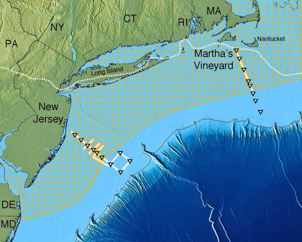
huge aquifer off the U.S. Northeast (hatched area). Solid yellow or white lines with triangles show ship tracks. Dotted white line near shore shows edge of the glacial ice sheet that melted about 15,000 years ago. Further out, dark blue, the continental shelf drops off into the Atlantic abyss. (Adapted from Gustafson et al., 2019)
Could Signal Resources Worldwide..
It appears to be the largest such formation yet found in the world.
The aquifer stretches from the shore at least from Massachusetts to New Jersey, extending more or less continuously out about 50 miles to the edge of the continental shelf. If found on the surface, it would create a lake covering some 15,000 square miles.
The study suggests that
such aquifers probably lie off many other coasts worldwide, and
could provide desperately needed water for arid areas that are now
in danger of running out.
The study (Aquifer
Systems extending Far Offshore on the U.S. Atlantic Margin)
appears this week in the journal Scientific Reports.
Starting about 20 years ago, study coauthor Kerry Key, now a Lamont-Doherty geophysicist, helped oil companies develop techniques to use electromagnetic imaging of the sub-seafloor to look for oil.
More recently, Key decided to see if some form of the technology could also be used also to find fresh-water deposits.
In 2015, he and Rob L.
Evans of Woods Hole Oceanographic Institution spent 10
days on the Lamont-Doherty research vessel
Marcus G. Langseth making
measurements off southern New Jersey and the Massachusetts island of
Martha's Vineyard, where scattered drill holes had hit
fresh-water-rich sediments.
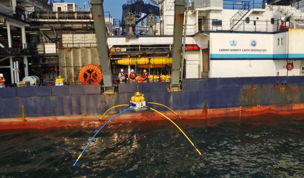
being deployed off the research vessel Marcus Langseth.
(Courtesy Kerry Key)
An apparatus towed behind the ship also emitted artificial electromagnetic pulses and recorded the same type of reactions from the subseafloor.
Both methods work in a simple way:
Analyses indicated that the deposits are not scattered; they are more or less continuous, starting at the shoreline and extending far out within the shallow continental shelf - in some cases, as far as 75 miles.
For the most part, they
begin at around 600 feet below the ocean floor, and bottom out at
about 1,200 feet.
They estimate that the region holds at least 670 cubic miles of fresh water.
If future research shows
the aquifer extends further north and south, it would rival the
great
Ogallala Aquifer, which supplies
vital groundwater to eight Great Plains states, from South Dakota to
Texas.
But the researchers say the new findings indicate that the aquifer is also being fed by modern subterranean runoff from the land.
As water from rainfall and water bodies percolates through onshore sediments, it is likely pumped seaward by the rising and falling pressure of tides, said Kerry Key.
He likened this to a person pressing up and down on a sponge to suck in water from the sponge's sides.
Also, the aquifer is generally freshest near the shore, and saltier the farther out you go, suggesting that it mixes gradually with ocean water over time. Terrestrial fresh water usually contains less than 1 part per thousand salt, and this is about the value found undersea near land.
By the time the aquifer
reaches its outer edges, it rises to 15 parts per thousand (typical
seawater is 35 parts per thousand.)
His group hopes to expand its surveys.
|


