|

by Andrea Mustain
OurAmazingPlanet Contributer
10 June 2010
from
LiveScience Website
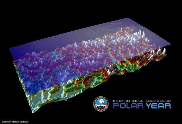
Gamburtsev
mountains of Antarctica
The image illustrates
the ice surface (transparent top layer with contour lines)
imaged from NASA's ICESat satellite and below that the
rugged bedrock topography of the Gamburtsev Subglacial
Mountains mapped from airborne geophysical data from the
AGAP project showing a surprisingly rugged mountain range
with deeply incised valleys beneath the ice sheet.
Credit: Michael
Studinger
The first detailed pictures of one of
the planet's last unexplored frontiers - a vast mountain range that
rivals the Alps in majesty buried underneath the ice of Antarctica -
were revealed by scientists this week.
The rugged peaks soar to more than 8,000 feet (2,400 meters). They
are buried beneath solid ice more than a mile (1.6 kilometers)
thick, deep within Antarctica's eastern interior.
The existence of this mountain range, called the
Gamburtsev Mountains, shocked the
Russian scientists who first discovered it more than 50 years ago,
and mystery still shrouds the nearly 750-mile- (1,200-km-) long
series of subglacial peaks.
At the International Polar Year conference in Oslo, Norway,
scientists unveiled new radar images of an area of the mountains the
size of the state of New York.
"What we'd shown before was an
estimate based on gravity data - a little bit of a coarse
resolution tool," said Robin Bell, a senior research
scientist at Columbia's Lamont-Doherty Earth Observatory in New
York. "What we showed at this meeting was the radar data. It's
like going from using a big, fat sharpie to using a fine-tipped
pencil."
What the pictures reveal, Bell said, is
spectacular: a dramatic landscape of rocky summits, deep river
valleys, and liquid, not frozen, lakes, all hidden beneath the ice.
Bell was among a team of scientists from seven countries who spent
two frigid months collecting geophysical data in the remote
antipodean wilderness via sophisticated, aircraft-mounted
instruments in late 2008 and early 2009.
The expedition provided researchers with several terabytes of
information - just one terabyte could hold two days worth of songs
or one million pictures. Although it will take years to process all
that data, Bell hopes the numbers will answer some of the questions
surrounding the Gamburtsev Mountains.
A big one is how they formed in the
first place.
"We now know it's not a volcanic
mountain range," said study team member Kathryn Rose,
of the British Antarctic Survey. "And uplift by a hotspot in the
mantle is probably out in terms of a mechanism of formation."
(The mantle is the scorching hot, molten rock that underlies
Earth's crust and is the source of volcanic magma.)
Rose said the data are also providing
invaluable insight into the evolution of the colossal East
Antarctica Ice Sheet - the 6 million square miles (15.5 million
square km) of ice that conceals the Gamburtsev Mountains and is
important to understand in terms of its potential to melt in a
warming world.
"Scientists need to improve our
understanding of ice sheets and their dynamics because it
impacts sea level everywhere," Bell told OurAmazingPlanet,
emphasizing that new insights are guaranteed for years to come.
"We're still scratching our heads as to how the mountains were
made and why they're still there," she said. "But I think we
have the data we need to solve the puzzle."
|