|


by D. Wilcock
January 2005
from
EnterpriseMission Website
Part One:
The Problem
1/8/05
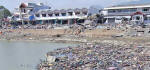
Most people say "it can't happen here" ....
... And then it did.
If the 9.2-magnitude Sumatra earthquake
had occurred along the Mid-Atlantic Ridge, then the resulting
tsunami would have wiped out a significant portion of the East Coast
of the United States of America. The economic, political and social
implications of such an event should be obvious -- it would make
9/11 look like a pre-school picnic by comparison (as this
Photoshopped image portrays above).
Unfortunately, there is the distinct scientific possibility for a
“mega-Sumatra catastrophe” … MUCH closer to home … as recently
reported by journalist, Steve Connor:
Tsunami: Why America's Coast Would Be Toast
Steve Connor
December 29 2004
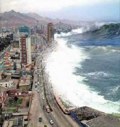
It sounds like the plot of a fanciful Hollywood disaster movie.
A dangerous volcano in the Canary Islands erupts, sends a giant
tsunami travelling faster than a jet aircraft into the major
population centres of America's east coast, killing tens of
millions and wiping out New York and Washington DC.
But unlike the eruption in the 1997 film Volcano (which
threatened in its tagline that 'the coast is toast') scientists
believe the threat from the volcano of Cumbre Vieja on the
island of La Palma is real, and that it could send a massive
slab of rock twice the size of the Isle of Man crashing into the
Atlantic.
The effect would be to generate a huge wave with the energy
equivalent to the combined output of America's power stations
working flat out for six months.
After travelling across 4,000 miles of the Atlantic for about
nine hours the tsunami would hit the Caribbean islands and the
east coasts of Canada and the US with devastating effect. It
would stretch for many miles and sweep into the estuaries and
harbours for up to 20 miles inland, destroying everything in its
path.
Those scientists are warning that the US government is not
taking the threat from Cumbre Vieja seriously enough and not
enough is being done to monitor it. Professor Bill McGuire, the
director of the Benfield Grieg Hazard Research Centre at
University College, London, warned that Boston, New York,
Washington DC and Miami could be virtually wiped out.
Professor McGuire said close monitoring might at best provide
two weeks warning of the disaster but that despite knowing about
the danger for a decade, no one was keeping a proper watch on
the mountain.
The two or three seismographs left to pick up signs of movement
in the rock were not capable of detecting a looming eruption
weeks in advance, Professor McGuire warned.
"What we need now is an
integrated volcanic monitoring set up to give maximum
warning of a coming eruption. The US government must be
aware of the La Palma threat. They should certainly be
worried, and so should the island states in the Caribbean
that will really bear the brunt of a collapse.
"They're not taking it
seriously. Governments change every four to five years and
generally they're not interested in these things," he added.
A monitoring station equipped to
look deep into the heart of the mountain and spot the early
signs of an eruption might cost hundreds of thousands of pounds.
In comparison, the US was spending $4m (£2.2m) a year scouring
the skies for kilometer-sized asteroids which were much less of
a threat, Professor McGuire said.
The Cumbre Vieja volcano last erupted in 1949 and its western
flank is highly unstable. It could literally split apart next
time the volcano erupts, which could be at any time in the next
1,000 years.
Any evacuation plan would have to be based on the forecast of an
eruption, since once the collapse happened it would be too late,
he said. However, it could be a false alarm. Several eruptions
could come and go before one of them sent the mountainside
crashing into the sea in a matter of minutes.
Professor McGuire acknowledged that the decision to depopulate
the US eastern seaboard would not be an easy one. "I don't
honestly know how we handle that," he said. "As scientists all
we should really do is advise people of what we think the risks
are."
The wave front from the collapse of the mountain would spread
out in a crescent, striking the west African coast with a wall
of water more than 300ft high in two to three hours. Its
northern side would also brush against Europe. Within three to
four hours, a 33ft-high wave would smash into the south coast of
England, causing immense damage.
If such an event were to happen close to
home, and we could know about it in advance and duly prepare,
potentially hundreds of thousands -- if not millions -- of lives
could be saved. Is it possible that someone could have predicted
this Sumatra quake in advance?
Let's do a "wish list" of a best-case
scenario for this type of event:
- We predict the exact day that
the quake will strike, perfectly.
- We predict the exact time that the quake will strike,
within 28 minutes of its arrival.
- We predict the exact coordinates where the quake will
strike, within 94.3 miles (157.1 km) of its actual location.
What you are reading is not a fairytale
or a fantasy. This exact prediction you just read was made, through
a strictly scientific process, and it came true, to the exact
specifications you see above.
[This data was presented in a report to members of the Department of
Science and Technology in New Delhi, India, on Dec. 22nd, 2004, by
Ph.D. candidate N. Venkatanathan ("V", below left)... just 4 days
before the quake itself. (Some of the background data used in this
article can be found here:
www.12thharmonic.com/astroturf/.)]
The only "mistake" that "V" made is the magnitude -- he predicted a
magnitude 6 or 7, when in fact it was a full two orders of magnitude
larger, at a factor of 9. Furthermore, he has now made 28 successful
predictions, with 75 to 80-percent accuracy and within a time window
of three to four days. In other words, every time he makes a
prediction with this technique, there is a 75 to 80 percent chance
that he is right about its location, and the timing is within a
three to four day window.
His predictive models are continually
getting more and more precise, as he indicates in the article below.
The shocking accuracy of his Sumatra prediction also clearly
indicates that he is, shall we say, "improving his game."
If you're starting to get interested now, ( ! ) you can read V's
paper here:
PLANETARY CONFIGURATION: IMPLICATIONS FOR
EARTHQUAKE PREDICTION.
Also, it's important to note here that "V" had already been
receiving mainstream media publicity for the quality and accuracy of
his results, prior to this incredible prediction being made.
The
Indian media published the following article on December 14th:
The Calcutta Telegraph
- Rao and Venkatanathan today told
The Telegraph that in 1974, US astrophysicist John Gribbin had
explained this concept in his book The Jupiter Effect. Gribbin,
they pointed out, had said that when two or more planets
“aligned more or less in line with the earth”, the latter was
“caught in the middle of a huge gravity [sic] struggle between
the Sun and the planets, especially the giant planet, Jupiter”.
Three planets — Uranus, Neptune and Pluto — were not taken into
consideration as they were farthest from the earth. But when
other planets aligned with the earth, the stress created by that
process could “change the speed of the earth in its orbit”. In
such a situation, Gribbin, they said, had warned that the centre
of the solar system could shift and the geological fault lines
“rip open, causing earthquakes”.
The researchers have downloaded ... software that gives the
planetary positions for any moment in a day. They are now
working to determine three other key parameters — the distance
of the epicentre from the planetary position, the direction of
the force acting on the possible epicentre and the [change in]
“angular momentum” ([an increase] or decrease in the [rotation]
speed of the earth).
After analyzing earthquake data of the last 100 years — provided
by the US Geological Survey — Rao and Venkatanathan said they
were able to arrive at what is called a “mean triggering
distance” of 626.125 km. It means that for every 626.125 km on
the earth’s surface, there is a possibility of an earthquake,
and they accordingly plot the hot spots on a map depending on
the other parameters when planets align with the earth.
Taking into account the other key factors, the researchers
claimed they were able to carry forward Gribbin’s insights for a
“much more accurate prediction of earthquakes”.
At the end of this feature, we reprint
the actual article that broke the story of Rao and Venkatanathan’s
astonishingly successful Sumatra prediction ... but only after the
devastating quake had occurred.
As long-time Enterprise readers are
aware, the empirical data used in their astonishingly accurate
prediction precisely confirms the “Hyperdimensional planetary
alignment” model that
Richard C. Hoagland has been lecturing,
speaking and writing about – including here on Enterprise -- for
nearly 20 years ….
Hopefully, within the next few weeks, we will be publishing an
updated Part Four of our continuing, groundbreaking "Interplanetary
Day After Tomorrow?" series – specifically, a section in
which we carefully document recent increasingly anomalous geological
and climate changes all around the Earth, talking place as part of
an overall “energetic transformation” that is occurring throughout
the Solar System.
It is vital that degreed scholars like N. Venkatanathan receive the necessary funding to continue and expand
the scope of their (and our) unique research into the fundamental
causes of these changes ….
We feel highly confident that these crucial natural phenomena – and
the increasingly obvious role they are playing in the military,
economic and social future of this planet -- involve “a whole new
realm of physics,” not currently understood by mainstream
geophysicists, meteorologists ... or, the political systems which
support their work.
A prime example: the now demonstrable role of
planetary alignments … in triggering significant “Earth changes” --
a role that (as we shall prove) goes far beyond simple
“gravitational effects.”
Some knew
it was coming
E. Saravanan
from
NewsTodayNet Website
Chennai, Dec 27:
N Venkatanathan, research scholar,
and N Rajeshwara Rao, research supervisor, Department of Applied
Geology, University of Madras.
The memories and the trauma caused by the tidal wave that washed
out parts of coastal Chennai and other parts of the State
yesterday will haunt the minds of the people for a long time to
come.
It is a tough task to forget the damage left behind by the wave
that was triggered by an earthquake in far-off Indonesia. The
Richter scale recorded the quake to be in the magnitude of 9.0.
What is so mysterious about the earthquake and the subsequent
tidal wave? Cannot it be predicted earlier and the people be
warned of it? Could necessary precautions be taken to minimize
the loss to life and property? In fact, the quake was actually
predicted by a team of research scholars of the Department of
Applied Geology, University of Madras, with a permissible error,
a week ago.
N Venkatanathan, research scholar, who is currently undergoing a
Ph.D programme in Predicting Earthquake and Aseismic
Construction Designing and the man behind the team working on
predictions, said he had already presented a report about the
Indonesian earthquake on 22 December to members of the
Department of Science and Technology, New Delhi.
The 15-member team headed by S K Tandan were in Chennai at that
time for a meeting.
Venkatanathan said, 'we predicted that the disaster would occur
on 26 December 2004 at 00:30 (GMT) with 3.54 N latitude and
97.17E longitude, which is located near the coast of Banyak
Island, Sumatra, Indonesia, with a magnitude at around 6 to 7.
The actual calamity occurred on 26 December 2004 at 00:58 (GMT),
with 3.298 N latitude and 95.779 E longitude, located off the
west coast of northern Sumatra'.
The difference in distance between the predicted place and the
epicentre was 157.11899 km, with a time difference of 28
minutes. He also said the team had predicted that the
after-shocks would occur at 700 km to the South of the epicentre
between 5 pm and 6 pm. This was recorded with permissible error.
It occurred at 157 km from the epicentre. That is with an error
of 521 km.
Venkatanathan and his guide N Rajeshwara Rao, a research
supervisor, as he calls him, admitted that "we didn't expect the
extent of damage it would cause to the Tamilnadu coast, since we
expected the magnitude might be around 7.0, which cannot damage
Tamilnadu. We never expected the consequent tidal waves that
would have such a devastating effect on the coastal areas of
Tamilnadu," admitted Rajeshwara Rao.
Venkatanathan explained that the prediction was based on a novel
method developed by the team. According to the method, when two
or more planets, the Sun and the Moon get aligned more or less
in line (0 to 180 degrees) with the earth, it could affect the
angular momentum of the earth and decrease the speed of rotation
of the earth, which could trigger an earthquake.
But in order to trigger an earthquake in one particular place,
two conditions should be taken into consideration, said
Venkatanathan. One is the distance of the planetary
configurations, and two is the directions of force acting at the
possible epicenter.
Venkatanathan also clarified that by analyzing the earthquakes
that had occurred over the last 100 years, it was inferred that
there was a role of planetary configurations in triggering
earthquakes.
He added that the team had earlier predicted the possibility of
earthquake occurrences at 27 places, among which Assam was one,
and presented a report at the International Conference of
'Hazards 2004' held at National Geophysical Research Institute,
Hyderabad.
He said the success of the prediction rate achieved so far was
around 75 to 80 per cent within a time-frame of plus or minus
three to four days.
Rajeshwara Rao said, "we are in the process of refining the
technique so as to achieve a better success rate, for which we
should have a network of inputs from various international
research organizations. For this to happen there is a need for
large-scale funding, which could be done through the
Government." He said with these things in mind, the department
had already submitted a proposal to the Tamilnadu government to
establish a Centre for Earthquake and Natural Hazards Studies (CENHAS).
The department had also submitted proposals for collaborative
programmes with Bulgaria and Uzbekistan through the Department
of Science and Technology (DST), New Delhi.
Go Back
|