by Mariaelisa Torres

March 9, 2010

from Poleshift Website


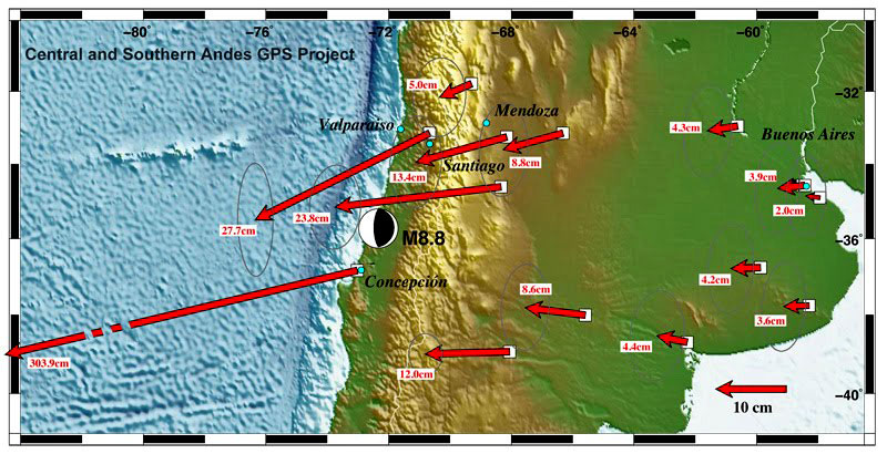
According to U.S. scientists, the Buenos Aires territory was moved by 4 cm. and that of Mendoza, by 13.


The Chilean Conception, the hardest hit by the quake, would have moved 3 meters.


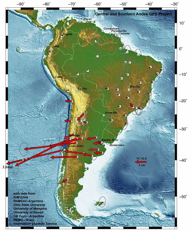
The map shows how much every city moved,

according to research (WIRED - UNIVERSITY OF HAWAII).
 

The devastating earthquake that rocked the western coast of Chile on February 27, caused a displacement of 3 meters to the west across the city of Concepción and moved several centimeters to other cities in South America.


According to a report by researchers at the University of Ohio, the earthquake of 8.8 degrees on the Richter scale, considered the fifth most powerful earthquakes in the world, since earthquake databases began to be maintained worldwide.


Conception is now 3 meters away from where it stood before the quake.


In the case of the capital city Santiago de Chile the displacement of 27.7 centimeters traveled south west and the city of Valparaiso also moved significantly, the report acknowledges that this is,

" a much more accurate picture of the power behind the earthquake, " says the report.

Argentina also was displaced.

"Buenos Aires has shifted from 2 to 4 inches to the west," reported the head of the Institute of Structural Mechanics and Seismic Hazard (IMERIS), Jorge Baron, adding that the province of Mendoza also experienced a shift in the order of 13 centimeters.

The researchers' deduced the movements of the cities by comparing the precise locations, established through the global positioning system (GPS), from before the earthquake and ten days after the earthquake.

The report indicates the potent earthquake shifted several inches other parts of South America, from the Brazilian city of Fortaleza to the Malvina Islands.


The specialist said,

"in the earthquake these stations have moved, that means that the ground has shifted to the west," adding that "is quite a deformation that has occurred in what is the central belt, especially Center-west of Argentina and Chile."

Last month's earthquake in Chile was at sea and these data measurements were done on the ground, so the IMERIS’ spokesperson advanced that,

"surely at sea the deformation or displacement has been much greater."

The report presented by the Ohio University, also benefited from the participation of the American Universities of Memphis and Hawaii, along with experts from Concepcion in Chile and the National Universities of Cuyo and Buenos Aires, Argentina.


In addition, investigators from the Military Geographic Institute of Chile also participated.


El Terremoto de Chile Desplazó Varios Centímetros Hacia el Oeste a America del Sur
Marzo 09, 2010

del Sitio Web ElClarin

Según científicos estadounidenses, el territorio bonaerense se corrió 4 centímetros y el de Mendoza, 13. La chilena Concepción, la más golpeada por el sismo, se habría movido tres metros.


El mapa muestra cuánto se movió cada ciudad,

de acuerdo a la investigación (Wired - Universidad de Hawaii).
 

El devastador terremoto que estremeció la costa occidental de Chile el pasado 27 de febrero, provocó un desplazamiento de 3 metros hacia el oeste de toda la ciudad de Concepción y, movió varios centímetros a otras ciudades de America del Sur.

De acuerdo con un informe presentado por investigadores de la Universidad de Ohio, el terremoto de 8,8 grados en la escala de Richter, considerado como el quinto de mayor poderío desde que se registran los sismos en todo el mundo, revelaron que Concepción se encuentra ahora a 3 metros de donde estaba antes del movimiento telúrico.

Por su parte, Santiago de Chile se desplazó 27,7 centímetros hacia el sur oeste, y la ciudad de Valparaíso,

"también se movió de manera significativa", explica el informe que reconocer que se trata de "una pintura mucho más precisa del poder detrás del temblor", indica el informe.

Argentina también se vio desplazada.

"Bueno Aires se ha desplazado entre 2 y 4 centímetros hacia el oeste", comentó el titular del Instituto de Mecánica Estructural y Riesgo Sísmico (IMERIS), Jorge Barón, quien agregó que la provincia de Mendoza tuvo también un desplazamiento del orden de los 13 centímetros.

Los investigadores,

"dedujeron los movimientos de las ciudades comparando las locaciones precisas", establecidas a través del sistema de posicionamiento global (GPS), de antes del terremoto y de diez días después.

El informe señala que el potente terremoto desplazó varios centímetros otras partes de América del Sur, desde la ciudad brasileña de Fortaleza a las islas Malvinas.

"En el terremoto se han desplazado estas estaciones, quiere decir que se ha desplazado la tierra hacia el oeste", dijo el especialista quien agregó que "es toda una deformación que ha ocurrido en lo que es la franja central, sobre todo centro-oeste de Argentina y Chile".

El terremoto del mes pasado en Chile fue en el mar y estos datos fueron diseñados sobre la tierra, por eso el titular del IMERIS adelantó que "seguramente en el mar la deformación o el desplazamiento ha sido mucho más grande".

El informe presentado por la Universidad de Ohio, contó además con la participación de de las universidades estadounidenses de Memphis y Hawai, junto a expertos de la Concepción, en CHILE, y la Nacional de Cuyo y Nacional de Buenos Aires, en Argentina.


Además, participaron investigadores del Instituto Geográfico Militar, de Chile.