|
by Joshua Sokol from QuantaMagazine Website
by an uncountable number of factors.
But
universal patterns have been found.
Simple physical principles can be used to describe how rivers grow everywhere
from Florida to
Mars...
Their grand plan never
went forward. But at some point in the process, da Vinci envisioned
what the entire hydrological system would look like from above.
To da Vinci, this patterning looked suspiciously alive.
Today, branching river networks still lure would-be explainers, many of whom hope to glimpse some underlying mathematical code responsible for etching out these common patterns.
It's no easy feat.
Geomorphologists have long measured statistical laws that river networks seem to obey 'the longest stream snaking through a basin,' for example, seems to be proportional to the area of the basin raised to the power of 0.6.
But these generic laws
haven't offered much insight into what actually shapes the networks.
And they all might
matter.
A team led by
Daniel
Rothman, a geophysicist at the Massachusetts Institute of
Technology (MIT), has spent the past few years arguing that a basic,
near-ubiquitous growth pattern can explain the shapes of river
networks carved into wet soils and maybe beyond.
sketched the Arno river west of Florence
as part
of a study of how it might be diverted. © Her Majesty Queen Elizabeth II 2018
Now they're looking even farther afield to Mars, and perhaps Saturn's moon Titan, each of which hosts its own mysterious branching channels.
Their basic math
doesn't work all the time, but it does work widely. And where it doesn't
work, the team believes, that breakdown provides its own hint to
underlying environmental conditions.
From Bump to Branch
These systems all follow what mathematicians call Laplacian growth, named for the 18th-century French mathematician Pierre-Simon Laplace.
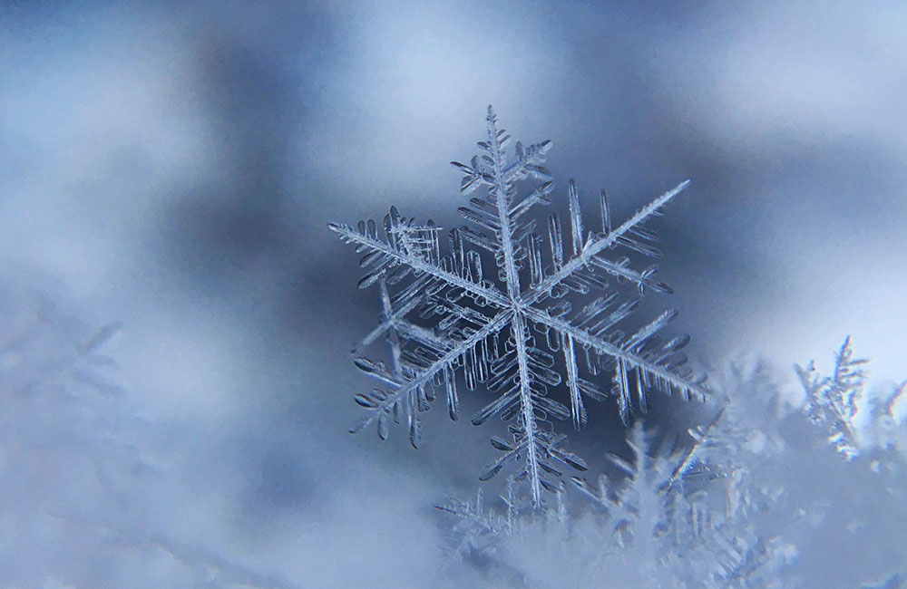
Snowflakes, analyzed up close, seem to sprout their symmetric-looking crystalline structures through Laplacian growth.
The process also predicts
the branching pattern that electric current takes when it leaps
across a gap, how bacterial colonies spread in petri dishes, and how
minerals grow into veiny, dendritic patterns that look like fossils
in rocks around the world.
Consider the surface of a newborn snowflake, a frozen edge creeping out into unfrozen ambient water. Invariably, what starts out as a smooth edge will have some little bump on it even just a few out-of-place atoms.
That bump will jut a little bit into the liquid.
Out there, the bump loses heat to the surrounding water a little faster. It cools, and a bit more water freezes on top of it. In time the bump grows, forming a bigger bump.
The process continues,
and soon enough the atomic imperfection extends into a crystalline
branch.
Eventually, the branches may spawn their own
bumps through the same process. That can make new branches that copy
the same shapes as their parent branches, only at smaller scales.
But the rub, for pattern
hunters, is to show that simple rules really do carry over into
messy reality.
A River Grows
As the channel tips grow,
they cut into 2-million-year-old sand. At each growing tip,
groundwater burbles to the surface. Just like the cold water around
a growing snowflake, it's the kind of environment that lends itself
to
Laplacian growth.
They flew to Florida and sloshed through these streams, measuring the rate at which water flows through individual channels.
Then they used
ground-penetrating radar to check the height of the water table
below.
demonstrate a remarkable statistical consistency.
But perhaps their most far-reaching result addresses a simple question:
The logic of Laplacian growth provides an answer.
Imagine zooming in close to the tip of a single growing channel. Here, groundwater flows into the channel from multiple directions.
As it does, the water pulls sand grains along with it.
Each missing grain
extends the channel a little bit.
If more water gushes in
from the right side of the channel head, for example, the channel
turns right. Soon, it points in the direction that makes the
groundwater flowing to it symmetric, where it receives the same
amount of water from either side.
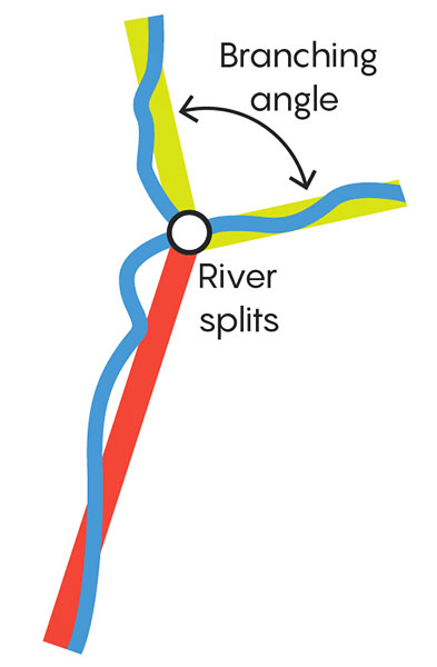
Competing effects determine the angle of the split. If the angle were wide, each new tip would bend inward, back toward the direction that maximized groundwater flow into the parent stream.
And if the angle were
narrow, the two tips would suck away each other's groundwater,
causing them to bend outward.
(The team later realized
that physicists had encountered the same angle in the early 2000s
while contemplating other Laplacian systems.)
Rothman and team members, ...found where streams in the intricate Florida network forked into two branches, at scales from large to small.
Then they measured the
angle of each junction.
Florida or Something
Fundamental?
Yes, Laplacian growth
appears to explain the patterning of one stretch of river in the
Panhandle. But what about the world's other rivers?
Branching angles vary widely, but for about half the country, they cluster around 72 degrees. And this June, Seybold extended the analysis still further, showing that the angle shows up across the globe.
It works just as well in
locations like the Amazon rainforest (where French Guiana borders
Suriname) as it does in Vermont.
Simulations of Laplacian growth demonstrate how similar structures
can emerge at many different size scales.
The wetter the area, these studies show, the more branching angles seemed to approach 72 degrees.
This could be because
groundwater tables are highest in the most humid regions, and the
same groundwater-powered mechanism found in the Florida Panhandle
might exert some control.
They buy the case in Florida, where Rothman's team nailed down the area's idiosyncrasies.
But they're more skeptical of the argument that branching angles suffice to show the same fundamental growth process is super widespread.
In the 1980s Alan Howard studied and simulated groundwater sapping out of sandstone in the southwestern U.S., eroding the rocks as it left them.
But both the sand and
sandstone networks have something rare in common. They occur in
places where groundwater dominates.
In rare cases where groundwater dominates, sure, Laplacian growth might work.
But elsewhere the mechanism doesn't quite make sense.
Christopher Paola, for his part, points back to the common branching angle.
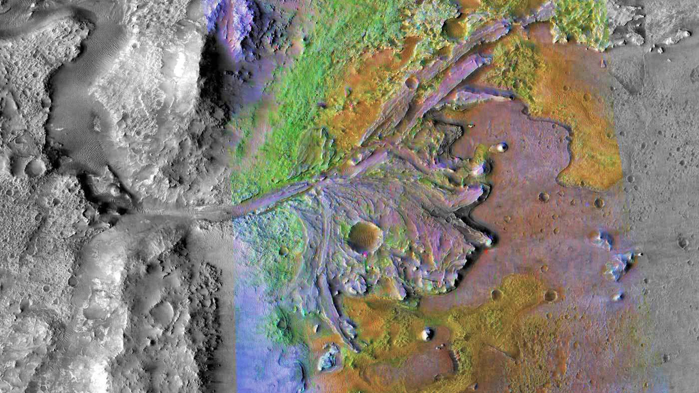
into Jezero Crater on Mars, the recently announced landing site
of
NASA's Mars 2020 rover.
That second angle "took me a long time of trying and failing" to explain by theory, Seybold said.
They still haven't solved the specific angle, but the team
argues that in arid regions, occasional surface runoff carves
steeper channels with narrower junctions.
If wet climate might brand
river networks with the 72-degree signature of Laplacian growth,
could that signature's absence also reveal the existence of a
different kind of climate?
Rivers on Mars
They looked at remote
sensing data from Mars, hoping that branching angles would hint at
the Red Planet's long-mysterious ancient climate.
Current cold temperatures and low pressures don't let surface water last very long there, so geomorphologists wondered whether the valleys could have been eroded.
The Martian valleys showed narrower angles, like those in arid places like the southwest U.S.
Consistent with other
recent studies, the new work suggests that the ancient Red Planet
was a relatively arid place. Perhaps occasional downpours carved the
Martian valleys, not groundwater.
|