by Andrej Flis

December 23, 2022

from Severe-Weather Website


Winter 2022/2023 began strongly, bringing record cold and snow into parts of the United States and Canada.

But what will the coming months offer regarding snowfall...?

First, we will look at the latest global drivers and then the snowfall predictions and trends from mid-Winter into the early Spring.

We have to take a quick look at the leading background drivers of global weather this winter season.

What does the latest analysis data show, and what influence did it play on temperature and snowfall patterns in the past?

But our primary focus is on global long-range weather forecasting systems.


We will show you their snowfall predictions for the rest of Winter and the early part of Spring.


GLOBAL WEATHER CONNECTIONS

A significant global weather factor this Winter is ENSO.


This region of the equatorial Pacific Ocean changes between warm and cold phases. Typically there is a phase change around every 1-3 years.

ENSO phases significantly influence tropical rainfall, pressure patterns, and the feedback between the ocean and the atmosphere.


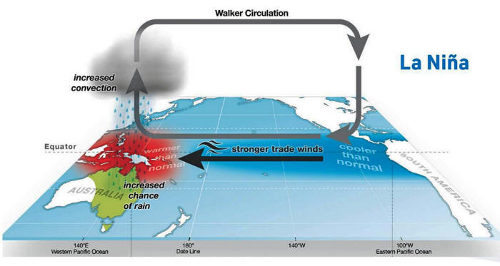
The image below shows the circulation pattern of a cold phase (currently active) and its ocean-atmosphere connection.


This way, the ENSO impacts tropical rainfall and pressure patterns, changing the atmosphere-ocean feedback system.


The ENSO influence is spread globally through this feedback system, creating a strong change in Winter temperature and snowfall patterns.

Below is the latest surface analysis of the tropical Pacific Ocean.


You can see the ENSO region in the cold phase (La Niña). But the cold anomalies are weakening, losing the organized shape, and starting to break down slowly.


La Niña usually forms during strong trade winds, which can tell us much about the state of global circulation.


This way, we can use these anomalies as an “indicator” to better understand the current state of the global climate system and its seasonal development.

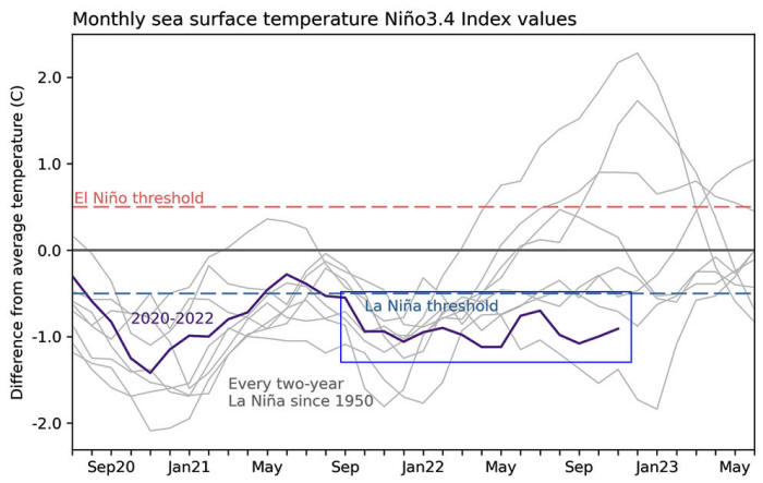
Below, you can see the progress of the ENSO temperature in the last two years. It shows that we are currently in a moderate negative phase lasting for a prolonged period.


This is also the final cold phase for at least two years.


As you will see, we will likely shift into a warm phase for the 2023/2024 Winter Season.


LA NIÑA WINTER FORECAST

Below we have an Official NOAA CPC probability forecast graphic, which shows the long-range forecast of the central ENSO region.


The cold La Niña conditions are forecast to decay quickly over Winter. However, going deeper into 2023, you can see an increased probability of a warm phase (El Niño) developing.


To better understand the ocean changes across the ENSO regions, we produced a video showing the La Niña anomalies from Summer into Fall.

So what exactly does this mean for the winter weather patterns and snowfall potential?


Despite weakening, La Niña is still active and creates its global influence. We will take a closer look at the weather effects that La Niña usually shows over North America, which is under a more direct influence.

Europe is not known to have any specific/direct influences, as it is too far from the source regions. But that does not mean it has no impact.

La Niña does change the weather globally, but apart from the direct influence over North America, places like Europe have many other factors in circulation before any La Niña influence can spread this far.


NORTH AMERICA WINTER PATTERNS


Continue reading HERE...