|
by Andrea Thompson
is one of the
strongest ever on record. could mean we surpass an important climate threshold... possibly for good.
Records are already being set well before the
event is expected to peak. And this year could set a record, only to
be eclipsed by 2027.
The question now is:
How El Niño
heats up the Planet
Normally, westerly winds pile warm waters up in the western tropical Pacific Ocean, but every few years, those winds slacken and sometimes even reverse, sending that water sloshing over to the eastern Pacific.
Aside from
raising coastal sea levels and
setting off a domino effect of changes in global weather patterns,
this shift releases massive amounts of heat from the ocean into the
atmosphere.
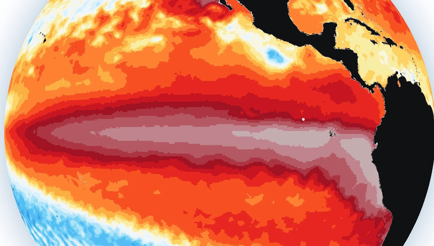
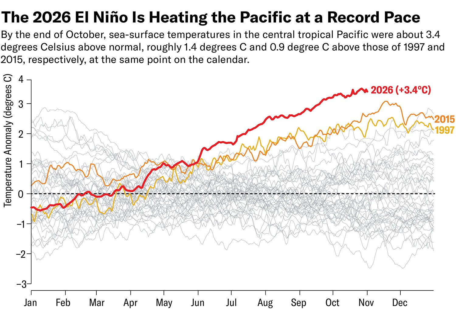
By September of this year, sea surface temperatures in the part of the Pacific that is El Niño's epicenter had already passed a daily record set in November 2015, and the phenomenon usually doesn't reach its fever pitch until November or December.
A line chart tracks daily sea-surface temperatures in the tropical central Pacific, known as the Niño 3.4 region, inº Celsius above or below normal.
Thin gray lines show each year since 1982, and the previous strongest El Niños, which occurred in 1997 and 2015, are highlighted.
The 2026 line pulls above the temperatures in
both of those years starting in June. And in late October it is
about 3.4º C above normal, very roughly a degree higher than 1997
and 2015 at the same point.
Source: El Niño–Southern Oscillation Forecast, Climate Dashboard
updated
November 2, 2026
They currently sit around a still jaw-dropping 3.4º C above normal.
Wherever sea surface temperatures peak between those numbers, they will absolutely smash the heat record from as long as we've had direct temperature measurements, which was set by an El Niño in 1877.
It would also be above estimates of past El Niño
sea surface temperatures taken from coral and tree growth rings
going back to the year 1100. And this year's event would likely set
a record even without the baseline ocean warming from climate
change.
Typically the global heat effects of El Niño come in the year after the event begins because it takes time for that heat to spread.
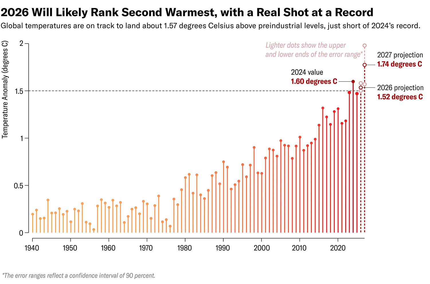
But whether or not it does, 2027 is virtually certain to take the crown.
Under the
landmark 2015 Paris climate agreement,
nearly 200 countries signed on to try to limit warming to no more
than that amount, with twoº C being a clear line that the world
vowed not to cross.
El Niño also drives drought that causes wildfires in many areas, which contribute massive amounts of planet-warming emissions to the atmosphere, says Kim Wood, an atmospheric scientist at the University of Arizona.
It's not impossible that these feedback effects could effectively lock in some of what would otherwise be a temporary global fever.
Sanidhya Sharma; Sources: Temperature, Climate Dashboard; updated November 2, 2026 (1940–2025 and 2026 projection); "State of the Climate: 2026 Likely to Tie with 2024 as the Warmest Year on Record," by Zeke Hausfather, in CarbonBrief. Published online November 3, 2026 (2027 projection)
After all, there's also a good chance the Pacific will swing into a La Niña,
This counterpart to El Niño depresses global temperatures, though even La Niña years now are much warmer than even El Niño years of decades past.
For example,
Hausfather acknowledges the possibility of staying above 1.5º C after this El Niño but says he,
If we don't stay above 1.5º C with this event, it's only a matter of time before we do.
A new study released on Monday in Nature Climate Change, though, has estimated that land areas around the world have already experienced 90 to 94 percent of the warming that would be expected in a world where global temperatures have reached 1.5º C above preindustrial.
United Nations agencies have also already acknowledged that,
But when exactly we breach 1.5º C for good
and for how long we stay
there depends heavily on decisions we make now and in the next few
years.
|