|
Chapter Nine
WHERE THE SUN
ALSO RISES
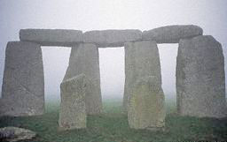
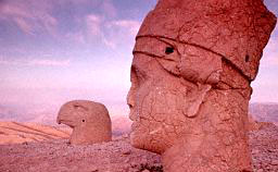
"No view epitomizes
Stonehenge more than the sight of the Sun’s rays shining through the
still-standing megaliths of the Sarcen Circle at sunrise on summer’s
longest day, when the Sun in its northern migration seems to
hesitate, stop, and begin to return.
As fate would have it, only
four of those stone pillars remain upright and connected at the top
of the curving lintels, forming three elongated windows through
which we, as though we were Stonehenge’s long-gone giant builders,
can also view - and determine - the beginning of a new annual cycle.
"And as fate would have
it, somewhere on the other side of the world, another set of three
windows in a massive structure of cyclopean stones - built, local
lore relates, by giants - also offers a breathtaking view of the Sun
appearing through white and misty clouds and direct its rays in
precise alignment.
That other place of the Three Windows, where the
Sun also rises on a crucial calendrical day, is in South America, in
Peru.
"Is the similarity just a visual fluke, a mere coincidence? We think
not.
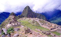
"Nowadays the place is called Machu-Picchu, so named after the sharp
peak that rises ten thousand feet at a bend of the Urubamba River on
which the ancient city is situated.
"It is now known that
it
was built long before the Incas, and that it’s olden name was
Tampu-Tocco, "Haven of the Three Windows."
The place, and its unique
windows, are featured in local lore regarding the origins of the
Andean civilization when the gods, led by the great creator Viracocha, placed the
four Ayar brothers and their four sister-wives
in Tampu-Tocco. Three brothers emerged through the three windows to
settle and civilize the Andean lands; one of them founded the
Ancient Empire that preceded that of the Incas by thousands of
years.
The reader may find more on the
construction of the Inca ruins on
Book Four "The Lost Realms".
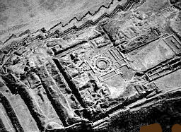
click image to
enlarge detail
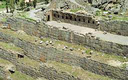
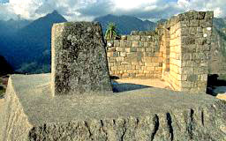
"....The Temple of the Three Windows
(click above image)
as Bingham named, has only
three walls: the one with the windows facing in an easterly
direction, and two sidewalls as protecting wings.
The western side
is completely open, providing room for a stone pillar, about seven
feet high; supported by two horizontally placed, carefully shaped
stones, one on each side, the pillar precisely faces the central
window.... and we believe that the pillar here served the same
purpose as the Heel Stone (at first) at Stonehenge or the
Altar
Stone (later on here), i.e, as the Seventh Pillar of Gudea to
provide the line of sight.
Ingeniously, the availability of three
windows made possible three lines of sight - to sunrise on midsummer
day, equinox day, and midwinter day.
"....Its other principal structure, also three-sided has its longest
wall on the Plaza’s (Sacred Plaza) northern end and is without a
wall on its southern face.... The central north wall has been so
constructed as to create seven false windows - trapezoidal cutouts
that imitate the three windows but do not in fact cut through the
stone wall.
A massive rectangular stone monolith, measuring fourteen
by five by three feet, lies on the structure’s floor below these
false windows.
"....The suggestion that the structure could have been related to
festival days i.e. to the calendar - is intriguing. The false seven
windows have six markedly protruding stone pegs above them, so that
some kind of counting involving seven and six - as at the Girsu in
Lagash - cannot be ruled out....
"....A smaller enclosure.... was built as an adjunct to the
Principal Temple.... It can best be described as a roofless room
with a stone bench; Bingham assumed that it was the priest’s abode,
but there is nothing there to indicate its purpose.
"....Right behind this enclosure there begins a stairway.... it
winds its way upward, leading from the Sacred Plaza up a hill which
overlooks the whole city. The top of the hill was flattened to
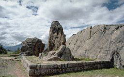
enable the construction of an enclosure.
There, in the center, where
the hill was flattened to form a platform an outcropping of the
native stone was left sticking out, then shaped and carved
magnificently to create a polygonal base from which a short stone
column projects upward. That the stone-on-a-base served
astronomical-calendrical purposes is evident from its name:
Inti-huatana, which in the local tongue meant "That which binds the
Sun."
As the Incas and their descendants explained, it was a stone
instrument for observing and determining the solstices, to make sure
that the Sun be bound and not keep moving away for good without
being pulled back to return.
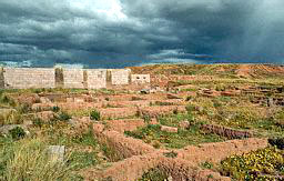
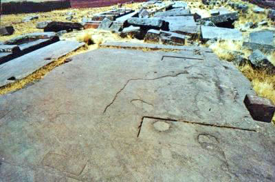
|
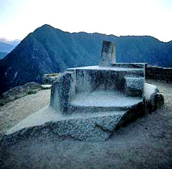 |
Intihuatana
Stone at left; Intihuatana Temple, above, Machu Picchu,
Peru. |
"Nearly a quarter of a
century passed between the discovery of Machu Picchu and the first
serious study of its astronomical connotations. It was only in the
1930s that Rolf Muller, a professor of astronomy at the University
of Potsdam in Germany, began a series of investigations at several
important sites in Peru and Bolivia....
"....Muller concluded (Die Intiwatana (Sonnenwarten) im Alten Peru
and other writings) that the short pillar atop the base, and the
base itself, were cut and shape to enable precise astronomical
observations at this particular geographical location and elevation.
The pillar served as gnomon and the base as recorder of the shadow.
However, the base itself was so shaped and oriented that
observations along its grooves could pinpoint sunrise or sunset on
crucial days.
Muller concluded that those preintended days were
sunset, on the day of the winter solstice (June 21 on the southern
hemisphere) and sunrise on the day of summer solstice (there,
December 23).
He furthermore determined that the angles of the
rectangular base were such that if one were to observe the horizon
along the diagonal sightline connecting protrusions (3 and 1,
diagram on book) one would
have observed sunset precisely on the equinox days at the time the
Intihuatana was carved.
"That, he concluded based on the Earth’s greater tilt at the time,
was just over four thousand years ago - sometime between 2100 B.C.
and 2300 B.C. This makes the Intihuatana at
Machu Picchu
contemporaneous with, if not somewhat older than, the Eninnu at
Lagash and Stonehenge II.
More remarkable perhaps is the rectangular
layout for the astronomical function of the Intihuatana’s base, for
it imitates the exceptional rectangular layout of the Four Station
Stones of Stonehenge I (though, apparently, without its lunar
purposes).
 "The
legend of the Ayar brothers relates that the three brothers
from whom the Andean kingdom stemmed.... got rid of the fourth
brother by imprisoning him in a cave inside a great rock, where he
was turned into a stone. Such a cave inside a cleft rock, with a
white vertical stem or short pillar inside, indeed exists at Machu
Picchu. "The
legend of the Ayar brothers relates that the three brothers
from whom the Andean kingdom stemmed.... got rid of the fourth
brother by imprisoning him in a cave inside a great rock, where he
was turned into a stone. Such a cave inside a cleft rock, with a
white vertical stem or short pillar inside, indeed exists at Machu
Picchu.
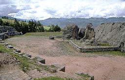
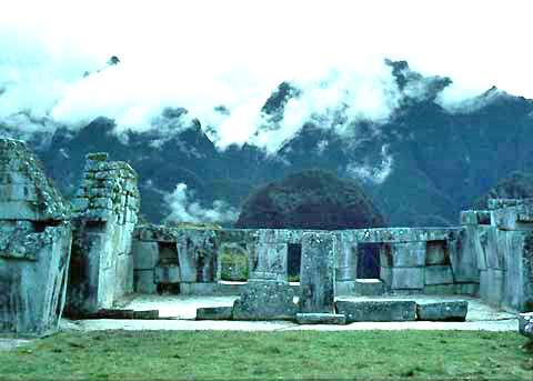
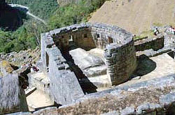
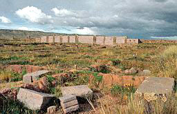
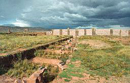
Above it one of the most remarkable structures in the whole
of South America still stands.... an enclosure which on two sides
for perfect walls at a right angle to each other, and on the other
two sides curves to form a perfect semicircle. It is know as the Torreon (the Tower)
(click image right)
The enclosure, which is reached by seven stone steps, encompasses,
as at the Intihuatana, the protruding peak of the great rock on
which it was constructed.
As with the Intihuatana, the outcropping
here was also carved and given a purposeful shape; except that here
no stem was made to act as a gnomon. Instead, the astronomical
sightlines that run along grooves and polygonal surfaces of the
"sacred rock" lead to two windows in the semicircular wall.
Muller,
and other astronomers after him.... concluded that the sightlines
were oriented to sunrises on the days of the winter and summer
solstices - more than four thousand years ago.
But there is another window:
"where the semicircle ended and the straight wall began, had a third
window - if one can so call the aperture. It is larger than the
other two, its sill is not straight, but is shaped as an inverted
stairway, and its top is formed not by a straight lintel stone but
by a wedgelike slit, like an inverted V.
"....In addition to the three apertures, there were nine false
trapezoidal windows in the straight parts of the enclosing walls.
Spaced between these false windows there protrude from the walls
stone pegs.... The longer wall which has seven false windows, has
six such pegs - duplicating the arrangement in the longer wall of
the Principal Temple.
"The number of the windows - actual plus false -
twelve, undoubtedly
denotes calendrical functions, such as the count of twelve months in
a year. The number of false windows (seven) and pegs (six) in the
longer wall, as in that of the Principal Temple, may indicate a need
to engage in intercalation - a periodic adjustment of the lunar
cycle to the solar cycle by adding a thirteenth month every-few
years. Combining with the alignments and apertures for observing and
determining the solstices and the equinoxes, the false windows with
their pegs lead to the conclusion that at Machu Picchu someone had
created a complex solar-lunar stone computer to serve as a calendar.
"The Torreon, contemporaneous with the Eninnu and with
Stonehenge
II.... presents the extremely rare circular shape of a stone
structure - extremely rare, that is, in South America, but with an
obvious kingship to the stone circles of Lagash and Stonehenge.
"....The Inca Empire was not the first kingdom with a capital at Cuzco in Peru. Researchers now know that the
legendary Incas, whom
the Spaniards encountered and subjugated, came to power in Cuzco
only in A.D. 1021. Long before them one of the Ayar brothers,
Manco
Capac, founded the city when a golden rod given him by the god
Viracocha sunk into the ground to indicate the right location. It
happened, by the calculations of Montesinos, circa 2400 B.C. -
almost 3,500 before the Incas.
"....When the Spanish conquerors arrived in
Cuzco, the Inca capital,
in 1533, they were astounded to discover a metropolis with some
100,000 dwelling houses, surrounding a royal-religious center of
magnificent palaces....
The Spaniards were amazed at the amount of gold in the empire’s
holiest temple.... Cori-cancha, meaning Golden Enclosure....
|
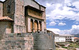
Coricancha,
Cuzco; with the addition built on the Inca structure by the
Catholic Priests.... |
"Chroniclers who had
seen the Coricancha before it was vandalized, demolished by the
Catholic priests, and built over into a church, reported that the
enclosed compound included a main temple, dedicated to the god Viracocha; and shrines or chapels for the worship of the
Moon,
Venus, a mysterious star called Coyllor, the
Rainbow, and the god of
Thunder and Lightning.
The Spaniards nevertheless called the temple
Temple of the Sun, believing that the Sun was the supreme deity
worshipped by the Incas.
"It is assumed that the
idea came to the Spaniards from the fact that in the Holy of Holies
of the Coricancha - a semicircular chamber - there hung on the wall
above the great altar an "image of the Sun." It was a great golden
disk which the Spaniards assumed to represent the Sun. In reality,
it had served in earlier times to reflect a beam of light as the
Sun’s rays penetrated the dark chamber once a year - at the moment
of sunrise on the day of the winter solstice.
"Significantly, the arrangement was akin to that in the
Great Temple
of Amon in Karnak, in Egypt. Significantly the Holy of Holies was in
the extremely rare form of a semicircle, as the Torreon in the
Machu
Picchu.... And, not surprisingly, careful studies and measurements
by Muller showed that the orientation designed to permit the beam of
sunlight to travel through the corridor and bounce off the "image of
the Sun" was conceived when the Earth’s obliquity was 24º, which
chronologically means, he wrote, more than four thousand years
earlier.
This matches the timetable related by Montesinos, according
to which the ancient Empire began circa 2500 - 2400 B.C. and the
assertion that the temple in Cuzco was built soon thereafter.
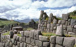
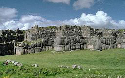
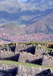
"....A megalithic Age with its colossal structures had obviously
preceded the Ancient Empire.... The prize for that should
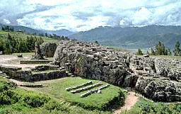
undoubtedly go to the ruins at Sacsahuaman, the promontory that
overlooks Cuzco....
"....As with the other megaliths at
Machu Picchu, the ones at
Sacsahuaman too were brought from a great distance, were given their
smooth and beveled faces and polygonal shapes, and remain holding
fast together without mortar.
"By whom, when, and why were these structures above ground, and the
tunnels, channels, conduits, bored holes, and other odd shapes
carved into the living rocks, made and fashioned? Local lore
attributed them to "the giants." The Spaniards, as the chronicler
Garcilaso de la Vega wrote, believed that they were "erected not by
men but by demons." Squier wrote that the zigzagging walls
represented without doubt the grandest specimens of the style called
Cyclopean extant in America," but offered no explanation or theory.
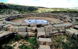
"Recent excavations have uncovered.... one of the most unusual
structural shapes in South America: a perfect circle.
"....This, however, was not the only circular structure on the
promontory. Assuming that the three tiers of colossal walls were
ramparts of a fortress, the Spaniards took it for granted that
structural remains in the highest and narrowest part of the
promontory, behind and above the walls, belonged to an Inca
fortification.... Archaeologists discovered that the area behind and
above the three walls was honeycombed with subterranean tunnels and
chambers.
More important they uncovered there the foundations of a
series of connected square and rectangular buildings; in their midst
there were the remains of a perfectly circular structure. The
natives refer to the structure as the Mayocmarca "The Circular
Building"; the archaeologists call it the Torreon -
The Tower - the
same descriptive name given to the semicircular structure at
Machu
Picchu, and assumed that it was a defensive tower, part of the
Sacsahuaman "fortress."
|
 |
 |
|
Ramparts of
Sacsahuaman
 |
|
Circular
Structure |
Areal view
of Sacsahuaman. The zigzagging walls and the circular
structure can be well appreciated. |
"Archaeoastronomers,
however, see in the structure clear evidence of an astronomical
function. R.T. Zuidema (Inca Observations of the Solar and Lunar
Passages, and other studies) noted that the alignment of the
straight walls adjoining the circular structure was such that the
north and south points of zenith and nadir could have been
determined there.
The walls that form the square enclosure within
which the circular structure was emplaced are indeed aligned with
the cardinal points; but they form only a frame for the circular
structure, which consisted of three concentric walls connected by
spokes of masonry that divide the outer two circular walls into
sections. One such opening - an aperture if the higher courses
forming the tower followed the ground plan - does point due south
and thus could have served to determine sunset on nadir day.
But the
four other openings are clearly oriented to the northeast,
southeast, southwest, and northwest - the unmistakable points of
sunset and sunrise on the winter and summer solstice days (in the
southern hemisphere).
"If these are, as it appears, the remains of a
full-fledged
astronomical observatory, it was in all probability the earliest
round observatory in South America, perhaps in all the Americas.
"The alignment of this round observatory to the
soltices puts it in
the same category as the one at Stonehenge and orientationally as
that of Egyptian temples. The evidence suggests, however, that after
the Megalithic Age and in the era of the Ancient Empire began under
the aegis of Viracocha, both the equinoxes and the lunar cycle
played the key roles in the Andean calendar.
"....According to the authoritative study
The Andean Calendar by L.E.
Valcarcel, such a fixing and veneration of the equinoxes was carried
into Inca times although they switched from an earlier equinoctial
calendar to a solstitial one.
"....The need to adjust the solar calendar over a period of
millennia because of the phenomenon of precession and , perhaps,
also due to the wavering between a solstitial and an equinoctial New
Year, led to repeat reforms of the calendar even in the days of the
Ancient Empire....
That such calendar reforms had to do with
wavering between solstices
and equinoxes is confirmed by the statement that the monarch Manco
Capac IV "ordered that the year begin in the spring equinox," a feat
possible because he was an Amauta, a "knower of astronomy."
But
evidently in doing so he only reinstated a calendar that had once
been in use, in earlier times; for, according to Montesinos, the
fortieth monarch who had reigned a thousand years before Manco Capac
IV, "established an academy for the study of astronomy and
determined the equinoxes, which the Indians called Illa-Ri.
"....In his studies of
Andean archaeoastronomy Rolf Muller reported
that a site called Pampa de Anta, some ten miles west of
Sacsahuaman,
the sheer rock has been carved into series of steps that form a
semicircle or crescent. Since there is nothing to view there except
the promontory at Sacsahuaman to the East, Muller concluded that the
place served to make astronomical observations along a sightline
anchored on the Sacsahuaman promontory - but apparently, linked to
appearances of the Moon. The native name for the edifice, Quillarumi,
"Moon Stone," suggests such a purpose.
"....In fact the early Spanish chroniclers stated repeatedly that
the Incas had an elaborate and precise calendar incorporating both
solar and lunar aspects.... The assertion that the Incas observed
both solar and lunar cycles is confirmed by the fact that next to
the shrine to the Sun in the Coricancha there was a shrine to the
Moon.
In the Holy of Holies the central symbol was an
ellipse
flanked by the Sun on the left and the Moon on the right; it was
only the ruler Huascar, one of the two half brothers who were
fighting over the throne when the Spaniards arrived, who replaced
the oval with a golden disk representing the Sun.
"These are
Mesopotamian calendrical features; finding them in the
remote Andes has baffled the scholars. Even more perplexing has been
the certainty that the Incas were familiar with the
zodiac - a
wholly arbitrary device for dividing the orbital cycle around the
Sun into twelve parts - a Sumerian "first" by all accounts.
"E.G. Squier, in his report on Cuzco and the meaning of its name
("Navel of the Earth"), noted that the city was divided into twelve
wards arranged around the nucleus or "navel" in an elliptical shape,
which is the true orbital circuit. Sir Clemens Markham (Cuzco and
Lima: The Incas of Peru) quoted the chronicler Garcilaso de la
Vega’s information that the twelve wards represented the twelve
zodiacal constellations. Stanbury Hagar.... showed that -
as in
Mesopotamia - the Incas also associated each of the twelve zodiac
"houses" with a parallel month in the calendar.... (bearing names
resembling their Near Eastern names that originated in Sumer).
"There were other aspects - complex aspects - of the
ancient Near
Eastern calendars in the calendar that the Incas had retained from
the days of the Ancient Empire. The requirement (still in force in
the Jewish and Christian calendars) that the spring festival
(Passover, Easter) be held when the Sun is in the relevant zodiac
house and on or immediately after the first full Moon of that month,
forced the ancient priest-astronomers to intercalate the solar and
lunar cycles.
The studies by R.T. Zuidema and others concluded that
only did such intercalation take place in the Andes, but the lunar
cycle was additionally linked to two other phenomena: it had to be
the first full Moon after the June solstice, and it was to coincide
with the first heliacal rising of a certain star. This double
correlation is intriguing, for it brings to mind the Egyptian
linking of the beginning of their calendrical cycle both to the
solar date (rising of the Nile) and the heliacal rising of a star
(Sirius).
"Some twenty miles northeast of Cuzco, at a place called
Pisac,
there are remains of a structure, probably from early Inca times,
that appear to have been an attempt to emulate and combine some of
the sacred structures at Machu Picchu....
"At a place not far from
Sacsahuaman called Kenko, a large
semicircle or well-shaped ashlars fronts on a large stone monolith
that could have had the shape of an animal (the features are too
damaged to be discerned); whether or not this edifice had
astronomical-calendrical functions is unknown.
These sites added to
those of Machu Picchu, Sacsahuaman, and
Cuzco, illustrate the fact
that in what has been called the Sacred Valley - and only there -
religion, the calendar, and astronomy led to the construction of
circular or semicircular observatories; nowhere else in South
America do we find such structures.
"Who was it who, at
about the same time, applied the same set of astronomical principles
and adopted a circular shape for celestial observations in early
Britain, at Lagash in Sumer, and in South America’s Ancient Empire?
"All legends, supported by geographical evidence and archaeological
finds, point to the southern shores of Lake Titicaca as the place of
the South American Beginning - not only of human civilization, but
of the gods themselves. It was there, according to the legends, that
the repopulation of the Andeans lands began after the Deluge; that
the gods, headed by Viracocha, had their abode; that the couples
destine to begin the Ancient Empire were given knowledge, route
instructions, and the Golden Wand with which to locate the site of
the Navel of the Earth - of establishing Cuzco.
"Insofar as
human beginnings in the Andes are concerned, the tales
connected them to two distinct islands off the southern shore of
Lake Titicaca. They were called the Island of the Sun and the Island
of the Moon, the two luminaries having been considered as the two
principal helpers of Viracocha; the calendrical symbolism inherent
in these tales has been noted by many scholars.
The abode of Viracocha was, however, in a
City of the Gods on the mainland at the
lake’s southern shore. The place, called
Tiahuanacu, was settled by
the gods (according to local lore) in times immemorial; it was, the
legends related, a place of colossal structures that only giants
could erect.
"....By the end of the nineteenth century the reports assumed a more
scientific accuracy as a result of the visits of researchers.... the
most renowned and tenacious researcher of Tiahuanacu,
Arthur Posnansky (Tiahuanacu - The Cradle of American Man).
Their work and
more recent excavations and studies, reviewed at length in
The Lost
Realms, have led us to conclude that Tiahuanacu
was the tin capital
of the ancient world, that its extensive above-ground and
underground structures were metallurgical facilities, that the huge
one-piece multiwalled stone blocks were part of port facilities at
the ancient lakeshore, and that Tiahuanacu was founded not by
Man
but by the Anunnaki "gods" in their
search for gold long before Man
was taught the uses of tin.
|
 |
 |
|
Foundations
at Tiahuanacu
 |
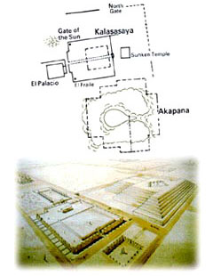
"Where a narrow and rare
plain fanned out from the southern shore of Lake Titicaca, the sight
of the once magnificent Tiahuanacu and its port (nowadays called
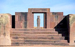
Puma-Punku), only three principal monuments to its past dominate the
landscape:
* the artificial hill of
Akapana, believed to have been a step
pyramid as a facility for the separation and processing of ores.
* the "Gate of the Sun," the single stone block from which it was cut
and shaped, measured about 10 by 20 feet and weight more than 100
tons.
The most enigmatic and elaborate carvings are on the upper front
side, facing due east. There the arch of the gate has been carved to
depict in relief a central figure - probably of Viracocha - flanked
on each side by three rows of winged attendants.
|
 |
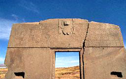
GATE OF THE
SUN |
"The writings of
Posnansky have established that the carvings on the gate represented
a twelve-month calendar of a year beginning on the day of spring
equinox in the southern hemisphere (September), yet a year where the
other major points of the solar year - the autumn equinox and the
two solstices - are also indicated by the positions and shapes of
the depicted smaller images. It was, he concluded, a calendar of
eleven months of thirty days each plus a "great month," a twelfth
month of thirty-five days, adding up to a solar year of 365 days.
"A twelve-month year beginning on the day of the spring equinox was,
as we now know, first introduced at Nippur, in Sumer,
circa 3800
B.C.
"The "Gate of the Sun," archaeologists have discovered, stands at
the northwest corner of what was a wall constructed of upright stone
pillars that formed a rectangular enclosure within which the third
most prominent edifice of the site stood. Some believe that there
was originally a similar gate at the southwestern corner of the
enclosure, flanking symmetrically a row of thirteen monoliths erected
in the precise center of the enclosure’s western wall.
That row of
monoliths, part of a special platform faced exactly the monumental
stairway that was built at the center of the eastern wall, on the
enclosure’s opposite side. The monumental stairway which was
unearthed and restored, led to a series of raised rectangular
platforms that encompassed a sunken courtyard.
Given the name Kalasasaya ("The Standing Pillars"), the edifice was
thus oriented precisely along an east-west axis, in the manner of
the Near Eastern temples. This was the first clue that it could have
served astronomical purposes...
"....The realization
that this ancient structure, more than twenty thousand feet up the
Andean mountains, in a desolate, narrow plain among snowbound
mountains, was a sophisticated calendrical observatory was
compounded by discoveries regarding its age.
Posnansky was the first
to conclude that the angles formed by the lines of sight suggested
an obliquity somewhat greater than the present declination of 23.5º;
it meant, he himself was astounded to realize, that the Kalasasaya
had been designed and built thousands of years before the Common
Era.
"....Investigations and thorough measurements left no doubt that the
obliquity prevailing at the time of construction was such that the
Kalasasaya could have been built circa 4050 B.C. or (as
the Earth
tilted back and forth) circa 10,050 B.C.
Muller, who had arrived at
a date of just over 4000 B.C. for the megalithic remains at
Machu
Picchu, was inclined likewise to date the Kalasasaya - a conclusion
with which Posnansky in the end agreed.
"....In
The Lost Realms we presented the evidence and arrived at the
conclusion that it was the same Anunnaki, those who had
come to
Earth from Nibiru in need of gold.
And, like the men who searched
for the golden El Dorado millennia later, they also came to the New
World in search of gold. The mines in southeastern Africa were
flooded by the Deluge; but the same upheavel uncovered the
incredibly rich veins of gold in the Andes.
"We believe that
Anu and his spouse Antu, visiting Earth from
Nibiru circa 3800 B.C., also went to see for themselves the new
metallurgical center on the southern shore of Lake Titicaca.
They
left by sailing away on the lake from the port facilities of Puma Punku, where the
cyclopean chambers, carved and shaped out a single
stone blocks, then stood along massive piers.
|
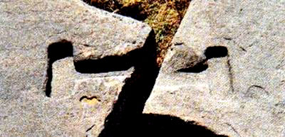
T-shaped
cutouts in adjoining stones for bronze
clamps - Puma Punku |
|
Slab of
Puma Punku Pyramid |
"The remains at
Puma Punku hold another enigmatic clue to the
amazing link between the structures at Lake Titicaca and the
unusual
temple to Ninurta that Gudea built.
To the disbelief of the site’s
excavators, they found that the megalithic builders had used
bronze
clamps, formed to fit T-shaped cutouts in adjoining stones, to hold
together the huge stone blocks.
Such a clamping method, and such a
use of bronze, were unique to the Megalithic Age, having been
found
only at Puma Punku and at another site of cyclopean megaliths,
Ollantaytambu, some forty-five miles northwest of
Cuzco in the Sacred
Valley.
"Yet thousand of miles
away, on the other side of the world, at Lagash in
Sumer, Gudea used
the very same unique method and the very same unique bronze clamps
to hold together the stones that, imported from afar, were used in
the construction of the Eninnu.
Recording in his inscriptions the
unusual use of stones and of metals, this is how Gudea lauded his
own achievements:
He built the Eninnu with stone,
he made it bright with jewels;
with copper mixed with tin [bronze]
he held it fast.
"It was a feat for which a
Sangu Simug, a "priestly smith," was
brought over from the "Land of Smelting." It was, we believe,
Tiahuanacu in the Andes.
Return
Chapter Ten
IN THEIR
FOOTSTEPS
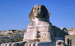
"The Great Sphinx of Egypt gazes precisely
eastward, welcoming the
rising Sun along the 30th parallel. In ancient times its gaze
welcomed the Anunnaki "gods" as they landed at their
spaceport in
the Sinai peninsula, and later on guided the deceased pharaohs to an
Afterlife, when their Ka joined the gods in their heavenly ascents.
At some time in between, the Sphinx might have witnessed the
departure of a great god - Thoth - with his followers, to be
counted
among the First Americans.
"...."For the last 50 years, the received wisdom has been that the
11,500-year-old artifacts found at Clovis, New Mexico, were made
soon after the first Americans found their way across the Bering land-bridge,"
Science magazine (21 February 1992 issue) wrote in an
update on the debate among scientists; "Those who have dared
question the consensus have met with harsh criticism."
The
reluctance to accept an earlier age and a different arrival route
stems primarily from the simple assumption that Man could not have
crossed the oceans separating the Old and the New Worlds at such
prehistoric times because maritime technology did not yet exist.
Notwithstanding the evidence to the contrary, the rock-bottom logic
continues to be, if Man couldn’t do it, it didn’t happen.
"The age of the
Sphinx has recently emerged as an analogous issue,
where scientists refuse to accept new evidence because it implies
achievements by Man when Man could not have achieved them; and
guidance or assistance by the "gods" - Extraterrestrials - is simply
out of consideration.
"In October 1991, some fifteen years after our initial presentation
of such evidence in The 12th Planet, Dr. Robert M. Schoch, a Boston
University geologist, reported at the annual meeting of the
Geological Society of America that meteorological studies of the
Sphinx and its layering indicated that it was carved out of the
native rock "long before the dynasties of the Pharaohs."
The
research methods included seismic surveying of subsurface rocks by
Dr. Thomas L. Dobecki, a geophysicist from Houston, and Egyptologist
Anthony West of New York and the study of weathering and watermarks
on the Sphinx and its surroundings. The precipitation-induced
weathering, Dr. Schoch stated, "indicated that work on the
Sphinx had begun in the period between 10,000 B.C. and 5000 B.C., when the
Egyptian climate was wetter."
"The conclusion "flies in the face of everything we know about
ancient Egypt," the Los Angeles Times added in its report of the
announcement. "Other Egyptologists who have looked at Mr. Schoch’s
work cannot explain the geological evidence, but they insist that
the idea that the Sphinx is thousands of years older than they had
thought just simply "does not match up" with what has been known.
The newspaper quoted archaeologist Carol Redmount of the University
of California at Berkeley: "There’s just no way that could be true .
. . The Sphinx was created with technology that was far more
advanced than that of other Egyptian monuments of known date, and
the people of that region would not have had the technology, the
governing institutions or the will to have built such a structure
thousands of years earlier."
"....The final argument by
the debunkers was the absence of evidence
that a civilization advanced enough to carve the Great Sphinx
existed in Egypt between 7000 and 5000 B.C. "The people during that
age were hunters and gatherers; they didn’t build cities," Dr. Lehner said; and with that
the debate ended.
"The only response to this
logical argument is, of course, to invoke
someone other than the "hunters and gatherers" of the era -
the
Anunnaki. But admitting that all evidence points to such more
advanced beings from another planet is a threshold that not
everyone, including those who find the Sphinx to be 9,000 years old,
is as yet ready to cross.
|
 |
"The same
Fear-of-Crossing (to coin an expression) has blocked for many years
not just the acceptance, but even the dissemination, of evidence
concerning the antiquity of Man and his civilizations in the
Americas.
"The discovery near Clovis, New Mexico, in 1932 of a trove of
leaf-shaped, sharp-edged stone points that could be attached to
spears and clubs for hunting, and subsequently as other North
American sites, led to the theory that big game hunters migrated
from Asia to the Pacific northwest some 12,000 years ago, when
Siberia and Asia were linked by an icy land-bridge.
In time, the
theory held, these "Clovis People" and their kindred folk spread
over North America and, via Central America, eventually also to
South America....
"....As linguistic research and genetic trace-backs joined other
investigative tools, the evidence began to mount in the 1980s that
humans arrived in the New World some 30,000 years ago - probably in
more than one migration, and perhaps not necessarily over an ice-bridge but by rafts or canoes hugging the coastlines.
"....That evidence, whose discovery was not only ignored but even
initially suppressed, pertains primarily to two sites where Stone
Age tools, crushed animals bones, and even petroglyphs have been
found.
"The first of these unsettling settlement sites is
Monte Verde, in
Chile, on the continent’s Pacific side. There, archaeologists have
found remains of clay-lined hearths, stone tools, bone implements,
and foundations of wooden shelters - a campsite occupied some 13,000
years ago. This is a date much too early to be explained by a slow
southward migration of Clovis People from North America.
Moreover,
lower strata at this campsite yielded fragmented stone tools that
suggest that the site’s human occupation began some 20,000 years
earlier. The second site is all the way on the other side of South
America, in Brazil’s northeast. At a place called
Pedra Furada, a
rock shelter contained circular hearths filled with charcoal
surrounded by flints; the nearest source of flint is a mile away,
indicating that the sharp stones were brought over intentionally.
Dating by radiocarbon and newer methods provided readings spanning
the period 14,300 to 47,000 years ago.
"....The ongoing challenge to the
Clovis theory in regard to the
time of arrival has been accompanied by a challenge to the
via-the-Bering-strait route as the sole path of arrival.
Anthropologists at the Artic Research Center of the Smithsonian
Institution in Washington, D.C., have concluded that the image of
animal-skin clad hunters carrying spears across a frozen wilderness
(with women and children in tow) is all wrong in thinking of the
first Americans.
Rather, they were maritime people who sailed in
rafts or skinboats to the more hospitable southern shores of the
Americas. Others, at the Center for the Study of the First Americans
at Oregon State University, do not rule out a crossing of the
Pacific via the islands and Australia (which was settled circa
40,000 years ago).
"....Who was there, tens of thousands of years ago, who possessed
the technology required for crossing vast oceans by boat, and how
could those prehistoric mariners have known that there was land,
habitable land, on the other side?
"This is a question that (also when applied to the
Age of the
Sphinx) has only one answer: the Anunnaki, showing Man how to cross
the oceans, telling him why and whereto - perhaps carrying him over,
"on the wings of eagles," as the Bible has described - to a
new
Promised Land.
"....The latest archaeological discoveries lend credence to memories
of early events that are called "myths" and "legends." Invariably,
they speak of multiple migrations and always from across the seas.
Significantly, they often involve the numbers seven and twelve -
numbers that are not a reflection of human anatomy or digital
counting, but a clue to astronomical and calendrical knowledge, as
well as to links with the Old World.
"One of the best preserved cycle of legends is that of the
Nahuatl
tribes of central Mexico, of which the Aztecs whom the Spaniards
encountered were the latest extant.... The earliest tribes, the oral
legends and the tales written down pictorially in books called
codices related, came down from Azt-lan, the "White Place," which
was associated with the number seven. It was sometimes depicted as a
place with seven caves out of which the ancestors had emerged;
alternatively, it was painted as a place with seven temples: a
central large step-pyramid (ziggurat) surrounded by six lesser
shrines.
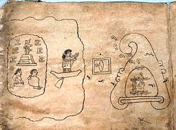
Codex Boturini contains a series of cartoonlike paintings
of the early migration by four tribes that began from the place of
the seven temples, involved crossing a sea in boats and a landing in
a place of cave shelters; the migrants were guided in that journey
to the unknown by a god whose symbol was a kind of
Seeing-eye attached to an elliptical rod.
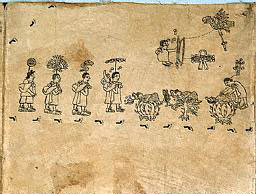
"The four clans of
migrants then trekked inland, passing by and following various
landmarks. Splitting into several tribes, one, the Mexica, finally
reached the valley where an eagle was perched on a cactus bush - the
signal for their final destination and the place where the Nahuatlan
capital was to be built.
It later developed into the Aztec
capital
whose symbol remained the eagle perched on a cactus bush. It was
called Tenochtitlan, the City of Tenoch.... (as explained in
The
Lost Realms): according to the Bible Cain, who was banished to a
distant "Land of Wandering," built a city and named it after his son
Enoch; and Enoch had four descendants from whom there grew four
clans.
"....Sahagun (Historia
de las cosas de la Nueva Espana), whose sources were verbal as well
as Nahuatlan tales written down after the conquest, recorded the sea
voyage and the name Panotlan, of the landing site; the name simply
meant "Place of arrival by sea," and he concluded that it was in
what is now Guatemala.
His information added the interesting detail
that the immigrants were led by four Wise Men, "who carried with
them ritual manuscripts and who also knew the secrets of the
calendar." We now know that the two - ritual and calendar - were two
sides of the same coin, the worship of the gods. It is a safe bet
that the Nahuatlan calendar followed the twelve-month arrangement,
perhaps even the twelve-zodiac division; for we read (in Sahagun’s
chronicles) that the Toltecs, the Nahuatl tribe that preceded and
taught the Aztecs, "knew that many are the heavens; they said that
there are twelve superimposed divisions" thereof.
"Down south, where the Pacific Ocean lapped the coasts of South
America, Andean "myths" did not recall pre-Diluvial migrations but
knew of the Deluge.... The legends do speak clearly of
new, post-Diluvial
arrivals by sea; the first or most memorable of them was one headed
by a leader called Naymlap....
"....An ancient relic made of pure gold, now kept in the
Gold Museum
of Bogota, Colombia, depicts a tall leader with his entourage atop a
balsa wood raft. The artwork may well have represented the sea
crossing by Naymlap or his like. They were well acquainted,
according to the Naymlap legend, with the calendar and worshiped a
pantheon of twelve gods.
Moving inland where Quito,
Ecuador’s
capital, is now situated, they built there two temples facing each
other: one dedicated to the Sun, the other to the Moon. The Temple
of the Sun had in front of its gateway two stone columns and in its
forecourt a circle of twelve stone pillars.
"....The veneration of both the Sun and the Moon indicates a
solar-lunar calendar, again as the one began in Sumer. A
gateway
with two stone columns in front of it brings to mind the two columns
that were erected at the entrances to temples throughout the ancient
Near East, from Mesopotamia through western
Asia and Egypt. And as
if all those links to the Old World were not enough, we find a
circle of twelve stone pillars. Whoever had arrived from across the
Pacific must have been aware of the astronomical stone circles of
Lagash, Stonehenge - or both.
"Several stone objects that are now kept in the
National Museum of
Peru in Lima are believed to have served the coastal peoples as
calendrical computers.
"....Fritz Buck (Inscriptiones Calendarias del Peru Preincaico) who
made the subject his specialty, was of the opinion (about a stone
object) that the 116 pegholes or indentations in the sixteen squares
indicated a link to the calendar of the Mayas of Mexico and
Guatemala. That the northern parts of the Andean lands were in close
contact with the people and cultures of Mesoamerica - a possibility
until recently rejected out of hand - is now hardly disputed.
Those
who arrived from Mesoamerica undoubtedly included African and
Semitic people, as evidenced by numerous stone carvings and
sculptures.... and before them Indo-Europeans have been depicted....
Another group may have arrived overland via the Amazon basin and its
tributaries; the symbols that were associated with them were
identical to the Hittite hieroglyph for "gods."
Inasmuch as the
Hittite pantheon was an adaptation of the
Sumerian pantheon, it
perhaps explains the otherwise remarkable discovery of a golden
statuette in Colombia of a goddess holding in her hands the emblem
of the umbilical cutter - the emblem of Ninharsag, the
Mother
Goddess of the Sumerians.
"....Scholars find that throughout the millennia the dominant
cultural influence on all these peoples was that of Tiahuanacu (Lake
Titicaca); it found its most obvious expression in the thousands of
clay and metal objects that bore the image of Viracocha as it
appears on the Gate of the Sun....
The most prevalent of those symbols or, as
Posnansky and others
consider them, hieroglyphs, was that of the stairway, which was also
used in Egypt, and which was often used on Andean artifacts to
denote a "Seeing-eye" tower. Such observations, to judge from the
astronomical lines of sight at the Kalasasaya and from the celestial
symbols associated with Tiahuanacu, included the Moon....
"On the Pacific side of South America, it thus appears,
the calendar
and its celestial knowledge followed in the footsteps of the same
teachers who had been active in the Near East.
"Commenting on the evidence, earlier discussed, for the much greater
antiquity of human presence in the Americas and their routes of
arrival, Dr. Niede Guidon, of the French Institute of Advanced
Social Studies who participated with Brazilian archaeologists in the
Pedra Furada discoveries, said thus: "A transatlantic crossing from
Africa cannot be ruled out."
"Pedra Furada is just
the most studied site in the area.... more than 260 archaeological
sites of early occupation are found there, and 240 of them contain
rock art. As the carbon dating of the charcoal samples from the
prehistoric hearths shows, Man lived there beginning some 32,000
years ago.
Throughout the area, such habitation appears to have come
to an abrupt end circa 12,000 years ago, concurrently with a marked
change in climate. It has been our opinion that the change coincided
with the abrupt end of the last ice age by the Deluge,
the Great
Flood....
"....A hiatus of some two thousand years followed until human
occupation of the site resumed, when other and new groups arrived in
the area. Their rock art suggests that they had come from a distant
land, for animals not native to the area were included in the
paintings: giant sloths, horses, an early type of llama, and
(according to the excavators’ reports) camels (which, to our eyes,
looked more like giraffes).
This second phase lasted till about
5,000 years ago and included, in its latter part, the making of
decorated pottery. It also included in its art, in the words of
Niede Guidon who has led the excavations, "abstract designs" that
"seem related to ceremonies or mythical subjects" - a religion, an
awareness of the "gods." It is at the end of that phase that the
transition to petroglyphs akin to Near Eastern signs, symbols, and
scripts make their appearance, leading in such a third phase to the
astronomical and calendrical aspects of the markings on the rocks.
|
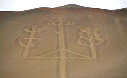
Candelabra or
Trident, Paracas, Peru |
"....Some scholars,
especially in South America, interpret various signs as a kind of
cuneiform Sumerian script.
The largest petroglyph in that zone is
the so-called
candelabra or trident that faces whoever reaches South
America’s Pacific shore at the Bay of Paracas.
According to local
lore it is the lightning rod of Viracocha, as seen atop the Gate of
the Sun in Tiahuanacu; we have identified it as the Near Eastern
emblem of the "Storm God," the younger son of
Enlil whom the
Sumerians called Ishkur, the Babylonians and Assyrians Adad, and the
Hittites Teshub ("The Wind Blower").
"....We have shown some of the
Hittite signs to be found in Brazil,
but probably much more lies unearthed and unstudied behind such a
coincidence as the fact that the hill people of Anatolia were the
first to introduce iron in the Old World, and the parallel fact that
the country’s name, Brazil, is identical to the Akkadian word for
iron, Barzel - a similarity that Cyrus H. Gordon (Before
Columbus and Riddles in History) considered to be a significant clue
regarding the true identity of early Americans.
Other clues are the
Indo-European types depicted on the busts found in Ecuador and
northern Peru, and the fact that the enigmatic inscriptions found on
Easter Island, in the Pacific Ocean opposite Chile, run as
the
Hittite script did in the "as the ox ploughs" system - beginning on
the upper line from left to right, continuing on the second line
from right to left, then again from left to right and so on.
"Unlike
Sumer, which was situated in an alluvial plain with no stone
therein to serve as building materials, the Enlilite domain of
Anatolia was all KUR.KI, "mountain land," of which
Ishkur/Adad/Teshub
was put in charge. The structures and edifices in the Andean lands
were also made of stone - from the earlier cyclopean stoneworks
through the exquisite ashlars of the Ancient Empire, down to the
fieldstone of the Incas and to the present....
"....Making an on-site visit to the ruins or
Hattusas, the ancient
Hittite capital, and other bastions nearby, some 150 miles northeast
of Ankara, the capital of present-day Turkey, one begins to realize
that in some respects they represented crude emulations of Andean stoneworks, even including the unique and intricate incisions in the
hard stone to create "the stairway motif."
|
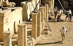 |
Ruins in
Anatolia |
"It is odd that in the
increasingly heated debate about the First Americans, little if any
attention has been given to the question of how much maritime
knowledge the ancient peoples possessed.
There are many indications
that it was quite extensive and advanced; and once again, the
impossible can be accepted as possible only if teachings by the
Anunnaki are taken into account.
"....Gilgamesh, having been mothered by a goddess went in search of
immortality. His adventures precede in time but exceed in drama
those of Odysseus, (of whom it is believed that he might have come
to America).
"....Gilgamesh is a known historical ruler of ancient
Sumer; he
reigned in Erech (Uruk) circa 2900 B.C. Centuries later, Sumerian
traders reached distant lands by sea routes, exporting the grains,
wool, and garments for which Sumer became known and exporting - as
Gudea has attested - metals, lumber, construction, and precious
stones. Such two-way repeated voyages could not have taken place
without navigational instruments.
That such instruments had existed in antiquity can be judged from an
object that was found in the eastern Mediterranean off the Aegean
island Antikythera at the beginning of this century....
"....The objects and materials raised from the wreck were taken to
Athens for examination and study. Among them were a lump of bronze
and broken-off pieces that, when clean and fitted together, stunned
the museum officials. The "object" appeared to be a
precise
mechanism with many gears interlocked at various planes inside a
circular frame that was in turn held in a square holder, it seemed
to be an astrolabe "with spherical projections and a set of rings."
After decades-long studies, including its investigation with X rays
and metallurgical analysis, it has been put on view in the National
Archaeological Museum in Athens, Greece (catalog number X.15087).
The protective housing bears a plaque that identifies the object as
follows:
"The mechanism was found in the sea of
Antikythera Island by sponge
divers in 1900. It was part of the cargo of a shipwreck which
occurred in the first century B.C. The mechanism is considered to be a
calendrical Sun and Moon
computing machine dated, after the latest evidence, to circa 80
B.C."
"....Even medieval astrolabes, more than a millennium after the
Antikythera time frame, look like toys compared to the ancient
object. Moreover, the medieval and later European astrolabes and
kindred devices were made of brass, which is easily malleable,
whereas the ancient device was made of bronze - a metal useful in
casting but extremely difficult to hone and shape in general and
especially to produce a mechanism that is more intricate than modern
chronometers.
"Yet the instrument was there; and no matter who provided the
science and technology for it, it proves that time-keeping and
celestially guided navigation were possible at that early time at an
incredible level of sophistication.
"It seems that the
reluctance to acknowledge the unacceptable also
lies behind the fact that hardly anything concerning early
cartography was brought up in the First Americans debate - even with
such an opportunity as the 500th anniversary of the Columbus voyage
in 1492.
"....In Istambul.... the Topkapi Museum, [keeps] another find that
throws light on ancient navigational capabilities. It is know as the
Piri Re’is Map....
"....The
Piri Re’is Map attracted particular interest for a number
of reasons: first, its accuracy and its sophisticated method of
projecting global features on a flat surface; second, because it
clearly shows the whole of South America, with recognizable
geographic and topographic features of both the Atlantic and Pacific
coasts; and third, because it correctly projects the Antarctic
continent.
Although cartographed a few years after the Columbus
voyages, the startling fact is that the southern parts of South
America were unknown in 1513 - Pizarro sailed from Panama to
Peru
only in 1530, and the Spaniards did not proceed farther down the
coast or venture inland to explore the Andean chain until years
later. Yet the map shows all of South America, including its
Patagonian tip.
As to Antarctica, not only how it looks, but its
very existence, was unknown until 1820 - three centuries after the
Piri Re’is map. Strenuous studies since the map was discovered in
1929 among the Sultan’s treasures have reaffirmed these puzzling
features of the map.
"Brief notations on the map’s margins are more fully explained in a
treatise titled Bahariyeh ("About the Sea") that the admiral wrote.
Regarding such geographic landmarks as the Antilles islands, he
explained that he obtained the information from "the maps of the
Genoese infidel, Colombo."
He also repeated the tale of how
Columbus
first tried to convince the grandees of Genoa and then the king of
Spain that according to a book that he (Columbus) possessed, "at the
end of the Western Sea (Atlantic), that is on its western side,
there were coasts and islands and all kinds of metals and also
precious stones."
This detail in the Turkish admiral’s book confirms
reports from other sources that Columbus knew quite well in advance
where he was going, having come into possession of maps and
geographic data from ancient sources.
"In fact, the existence of such earlier maps is also attested to by
Piri Re’is. In a subsequent notation, which explains how the map was
drawn, he listed maps made by Arab cartographers, Portuguese maps
("which show the countries of Hind, Sind and China"), the "map of
Columbus," as well as "about twenty charts and Mappae Mundi; these
are charts drawn in the days of Alexander, Lord of the Two Horns."
The latter was an Arabic epithet for Alexander the Great, and the
statement means that Piri Re’is saw and used maps from the fourth
century B.C. Scholars surmise that such maps were kept in the
Library of Alexandra and that some must have survived the
destruction by fire of the great hall of science by Arab invaders in
A.D. 642.
"It is now believed that the suggestion to sail westward on the
Atlantic to reach existing coasts was first made not by Columbus but
by an astronomer, mathematician, and geographer from Florence,
Italy, named Paulo del Pozzo Toscanelli in 1474. It is also
recognized that maps, such as the Medicean from 1351 and that of
Pizingi of 1397, were available to later mariners and cartographers;
the most renown of the latter has been Gerhard Kremer, alias
Mercator, whose Atlas of 1569 and methods of projection have
remained standard features of cartography to this day.
"One of the odd things about
Mercator’s maps of the world is that
they show Antarctica, although that ice covered continent was not
discovered, by British and Russian sailors, until 250 years later,
in 1820!
"As those who had preceded ( and succeeded) him,
Mercator used for
his Atlas earlier maps drawn by former cartographers. In respect of
the Old World, especially the lands bordering on the Mediterranean,
he obviously relied on maps that went back to the time when
Phoenicians and Carthaginians ruled the seas, maps drawn by
Marinus
of Tyre that were known to future generations by the astronomer,
mathematician, and geographer Claudius Ptolemy who lived in Egypt in
the second century A.D. For his information of the New World, Mercator relied both on olden maps and the reports of explorers
since the discovery of America.
But where did he get the data not
only on the shape of Antarctica, but on its very existence?
|
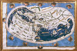
Facsimile of
a fifteenth century Map of the World according to
Ptolemy. |
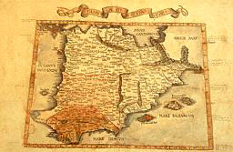
Medieval Map
of Iberia |
"Scholars agree that his
probable source was a Map of the World made in 1531 by Orontius
Finaeus.
Correctly projecting the Earth’s globe by dividing it into
the northern and southern hemispheres, with the north and south pole
as epicenters, the map not only shows Antarctica - an amazing fact
by itself. It also shows Antarctica with geographical and
topographical features that have been buried under and obscured by
an ice sheet for thousands of years!
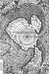 "The map shows in unmistakable detail coasts, bays, inlets,
estuaries and mountains, even rivers, where none are now seen
because of the ice cap that hides them. Nowadays we know that such
features exist, because they were discovered by scientific below-ice
probing that culminated with intensive surveys by many teams during
the International Geophysical Year, 1958. "The map shows in unmistakable detail coasts, bays, inlets,
estuaries and mountains, even rivers, where none are now seen
because of the ice cap that hides them. Nowadays we know that such
features exist, because they were discovered by scientific below-ice
probing that culminated with intensive surveys by many teams during
the International Geophysical Year, 1958.
The depiction (which
appears on Mr. Sitchin’s book) on the Finaeus map
(click image right) it then became
clear, uncannily resembles the true shape of the Antarctic continent
and its various geographical features.
"....Charles H. Hapgood (Maps of the Ancient Sea Kings) concluded
that the Finaeus map was drawn by him based on ancient charts that
depicted Antarctica at a time when the continent, after having been
freed of its ice covering, began to be covered by ice again on its
western parts. That, his research team concluded, was about six
thousand years ago, circa 4000 B.C.
"....Presenting his conclusions in
Maps of the Ancient Sea Kings,
Charles Hapgood wrote: "It becomes clear that ancient voyagers
travelled from pole to pole. Unbelievable as it may appear, the
evidence nevertheless indicates that some ancient people explored
Antarctica when its coasts were free of ice.
It is clear, too, that
they had an instrument of navigation for accurately determining
longitudes that was far superior to anything possessed by the
peoples of ancient, medieval, or modern times until the second half
of the 18th century."
Mr. Sitchin continues:
"But those ancient mariners, as we have shown, only followed in the
footsteps of the gods.
Return
|