Foreword - A Cautionary
Note To UFO Buffs
Persistent rumors of secret underground
bases and deep underground tunnel systems have swirled through the field
of UFOlogy for some years now.
These underground installations are variously said to be constructed,
staffed and operated by covert human agencies (either part of the
military-industrial complex or various federal government agencies), or
by extraterrestrial or alien beings (the so-called "Little Greys" often
mentioned in the UFO literature), or by both covert human agencies and
aliens working together in secret, underground installations.
I will say at the outset that my research has not revealed whether or
not Little Greys even exist, much less whether or not they are living
and working in underground installations.
Perhaps the
Little Greys
really do exist; perhaps they do not.
But since I cannot definitively
answer the question one way or the other, I will not deal with it to any
great degree in this report. Neither will I discuss reported cases where
abductees have been taken into purported underground installations,
where they have allegedly seen and experienced many strange things,
including bizarre medical procedures and biological engineering
experiments.
Though I have both heard and read such stories I cannot
testify as to the veracity of these reports, so I will not concentrate
on them here. These anecdotal accounts are interesting, however, and I
am keeping an open mind about them.
What I do know for certain is that there are many underground
installations here in the United States.
I also know that the military-industrial complex and various federal
government agencies have constructed, and are working in, many of these
installations.
I also know that throughout virtually the entire post-WW II period (and
perhaps before) the United States government has been actively planning
and constructing underground facilities and installations, some of which
are very deep underground, quite sophisticated and capable of
accommodating large numbers of people. I have documented quite a number
of these facilities and will describe them, to the extent that I am
able, in this book.
I have also been told of many other underground
facilities that I am presently not able to document. For that reason,
most of them will not be discussed here.
I have been able to find considerably less information about the
much-rumored tunnel system said, by some reports, to crisscross the
United States. This does not mean that it does not exist. It may simply
be that its deep underground location (if it really exists) gives it a
natural cover that is hard to break. Or maybe it really does not exist!
I don't know for sure one way or the other.
Whatever the case, I will
present what information I have uncovered about tunneling technology and
tunnel systems - the kind of information that may well form the popular
basis for the rumored underground tunnel system.
My approach to the tunneling and tunnel network issue is the same as to
the underground base question: I will present for my readers reports,
information and facts that I have discovered and leave them to draw
their own conclusions. I trust that most of what follows will be as new
and intriguing for others to read as it was for me to discover.
I understand that some readers may object to the publication of
information about military facilities. However, it is my feeling that
the aims and ideals of representative democracy are poorly served by
secrecy in government, especially in the policies of the armed services.
History teaches us that when a country has an exceptionally powerful
military, and when that military carries out secret policies and agendas
like the U.S. military does (think of the illegal Iran-Contra affair, of
super-secret nuclear bomb testing in Nevada, of the astronomical amounts
of money given to the Pentagon every year for so-called "black
projects"), then there is an ever present danger of that military taking
control of the government.
That control could be taken quickly - or
gradually. Noisily or quietly. But dictatorships are born when power is
usurped by the military. God forbid that a military dictatorship should
ever march under the stars and stripes of the United States of America.
Protection against that ever happening begins with the exercise of our
First Amendment right to speak freely.
So, in that spirit, and in the hope that some of what follows will help
peel away the cover of excessive secrecy that shields too much of what
the Pentagon does from public scrutiny, I offer solid documentation of
underground military installations, as well as official plans and
documents pertaining to the construction, operation and planning for
such installations.
I would like to briefly relate an unpleasant incident involving the U.S.
Army Corps of Engineers. In December 1992, while researching this book,
I filed a Freedom of Information Act Request with the U.S. Army Corps of
Engineers.
My request sought information about the Corps' involvement in
underground base and tunnel construction and maintenance. As it happens,
I was at that time a PhD candidate in political science working on my
doctoral dissertation. After getting no substantive response to my
request, I called the Pentagon and was referred to the Army Corps'
Freedom of Information Office.
I subsequently called that office and
complained about the Corps' noncompliance with my request. A few days
later an attorney for the Army Corps of Engineers called my dissertation
advisor to complain about me. He informed my dissertation advisor that
if I wanted to get bureaucratic that he would show me what
"bureaucratic" was!
Subsequently I received a letter from the Corps denying my request for a
fee waiver and stating that I would have to pay all fees related to
searching for and providing documentation on their subterranean
construction and maintenance activities. Needless to say, this could
easily have run to thousands of dollars.
As a result, that information is not in this report. However, I still
found plenty of other information relating to the U.S. Army Corps'
underground construction activities and it is all discussed in detail in
the pages that follow. So the Army's attempt at suppressing my First
Amendment rights was not entirely successful. The free press lives!
Chapters 7 and 9 of this book were first published in UFO Magazine,
edited by Vicki Cooper.
Now, let's go underground - and see what's there!
RICHARD SAUDER, Ph.D.
January 1995
Back to
Contents
Chapter One
Oh Yes, They're Real!
Do secret, underground government installations exist? The answer is
absolutely, positively - yes. They are real.
In 1987, Lloyd A. Duscha, the Deputy Director of Engineering and
Construction for the U.S. Army Corps of Engineers, gave a speech entitled
"Underground Facilities for Defense - Experience and Lessons."
In the first
paragraph of his talk he referred to the underground construction theme of
the conference at which he was speaking and then stated:
"I must deviate a
little because several of the most interesting facilities that have been
designed and constructed by the Corps are classified."
Mr. Duscha
subsequently launched into a discussion of the Corps' involvement, back in
the 1960s, in the construction of the large NORAD underground base beneath
Cheyenne Mountain, Colorado (See Chapter 3 for a more detailed discussion of
the NORAD installation).
And then he said:
"As stated earlier, there are
other projects of similar scope, which I cannot identify, but which included
multiple chambers up to 50 feet wide and 100 feet high using the same
excavation procedures mentioned for the NORAD facility." 1
I submit that you will probably not find a more honest admission anywhere by
a military officer that the Pentagon has, in fact, constructed secret
underground installations.
Given such an explicit admission, within the context of the paper trail that
the military has left over the last 35 years (set out in this book in
considerable detail), and the stories that I have heard from other
individuals, I consider it an absolute certainty that the military has
constructed secret underground facilities in the United States, above and
beyond the approximately one dozen "known" underground facilities listed
elsewhere in this book.
Just a few of the many places where these underground facilities are alleged
to be are:
-
Ft. Belvoir, Virginia (home of the Army Corps of Engineers)
-
West Point, New York (site of the Army's
officer training academy)
-
Twentynine
Palms Marine Corps Base, in southern California
-
Groom Lake or Area S-4, on
or near Nellis Air Force Base, in southern Nevada
-
White Sands Army Missile
Range, New Mexico
-
under Table Mountain, just north of Boulder, Colorado
-
under Mount Blackmore in southwestern Montana and near Pipestone Pass, just
south of Butte, Montana
I would be glad to hear from individuals with
information about any of these alleged facilities.
But not all underground installations are secret military projects. Many
underground tunnels and facilities have been built that are not covert in
any way. There are numerous highway and railroad tunnels, and many major
cities have extensive subway systems. There are also miles of utilities,
such as water lines and sewer tunnels, with accompanying pumping stations.
Some of the most complex, non-covert underground facilities that have been
built are for hydroelectric powerhouses. The rooms and halls in these kinds
of plants can be hundreds of feet below the surface and quite huge in some
cases.
For example, the powerhouse at Portage Mountain Dam in British
Columbia, Canada is 890 ft. long, 66.5 ft. wide and 152.5 ft. from top to
bottom. Of special note is the method used to deliver concrete to the
powerhouse chamber during construction. An 8-in diameter pipe was run 400
ft. from the ground surface down to the construction area, and the concrete
was delivered through the pipe.2
But if such extraordinary human ingenuity and effort can bring into being
the tunnels through which we freely drive our cars, and the power stations
which deliver electrical power to our homes, it requires no great stretch of
imagination to suppose that installations of similar, or even greater, size,
complexity and depth could have been built underground, perhaps covertly, by
agencies of the United States government and huge corporations.
As this book
reveals, our government - and the contractors with which it works - has the
personnel, technical know-how, machinery and money to plan and complete
mammoth underground construction projects.
Where are the bases?
In the pages that follow I will list, one
by one, as many of the known underground facilities in the United States and
Canada that are operated or maintained by United States government agencies
and major corporations as I can presently document, reporting as much
information about each one as possible.
For some, I can report only that
they exist; for others, I can say a good deal more.
As it happens, there are
many similar deep underground facilities in other countries. Sweden,
Switzerland, France, Saudi Arabia, Israel and Russia are known to have
sophisticated underground installations - and, presumably, yet other
countries have them as well. In this book I will restrict my discussion only
to North American facilities. So there is no question that secret
underground bases exist.
But how do they get there? How is it possible to
plan, build, and operate them, all in secrecy?
As it happens, it is easier
than the average person might suspect.
In 1985 the U.S. Army Corps of Engineers published a report entitled
Literature Survey of Underground
Construction Methods for Application to Hardened
Facilities
The report concluded that,
"Since adequate technology
is available to construct hardened underground facilities under virtually
any ground conditions, the main constraint in construction projects remains
economic viability rather than technical feasibility."
In other words, with
enough money, underground facilities can be built almost anywhere.
Given the
huge buildup in military budgets under the administrations of Ronald Reagan
and
George Bush one cannot help but think that "economic viability"
- money - may not have been a drawback at all, especially for projects done beginning
in the early 1980s.
In very general terms the Army Corps report discusses a variety of types of
underground facilities and construction techniques.
Two of the types of
underground facilities it discusses are:
-
deep shaft structures
-
tunneled structures in mountainsides
Inspect Illustration 1.3. Notice that tractor trailer trucks are depicted as
entering both kinds of structures.
In the mountainside facility the truck
appears to drive in through a tunnel. In the deep shaft structure truck
entry appears to be via an access building and some kind of vertical hoist
or elevator that would seem to be implicit in the layout of the facility.
The deep shaft structure is also shown with an accompanying ventilation
shaft to the surface, which has its topside terminus in a "protective
enclosure."
How To Hide An Underground Base
To illustrate just how well hidden such
underground facilities - and the entrances that give access to them can be,
consider the examples of two actual, underground installations.
One of them
is in England, the other in Sweden.
First, the Swedish installation:
In central Sweden there is an underground factory excavated deep into a
granite mountain which employs nearly 3,000 workers and manufactures diesel
and gasoline engines, agricultural machinery, and various machine tools.
As
you approach this installation, the only man-made structure apparent to the
unaccustomed eye is an innocent looking Swedish farm house, located at the
foot of a hill. However, when the hinged walls of this house swing open,
much like large garage doors, there is an opening of sufficient size to
accommodate large trucks.4
Consider that these words were written in 1949, during the immediate
post-war period. If in the 1940s the Swedes could disguise the entrance to a
major, underground, industrial facility as an ordinary farm house, what
might the Pentagon be capable of today?
Clearly, the possibilities are
extensive.
Now for the English example.
Until 1989 the War Headquarters of the British
Army's UK Land Forces Command was situated in an underground bunker 50 ft.
below a field in Sopley, Hampshire.
When it was active the sign in front of
the installation identified the place as a "training area" for the "No. 2
Signals Brigade." (This is more than a little reminiscent of the two U.S.
Army "Warrenton Training Center" stations mentioned later.)
The English
bunker has now been replaced by a newer facility elsewhere, but the
interesting thing about the now abandoned Sopley facilities is how
nondescript the entrance is.
On the surface, only a guardhouse and two ventilator shafts now stand in an
empty, but fenced-off field... A shaft concealed at the back of the
innocuous looking guardhouse gives access to a stairwell and underground
tunnel - at the end of which is a two-story bunker with about 50 rooms.5
I strongly suspect that the designers here in the United States have been at
least as ingenious as their counterparts in Europe in disguising and
concealing entrances to underground installations. Virtually any house
anywhere, or any building, large or small, is capable of concealing an
entrance to an underground facility.
This is not the same, of course, as
saying that every house and building that one sees is, in reality, a
disguised underground base entrance.
Still, as the above examples show, some
houses and buildings certainly can be disguised entrances for such
facilities. Since they don't have signs on them advertising the fact, the
hard part is figuring out which ones they are.
To say that this is not easy
is an understatement.
Starting Construction - One Case History
So underground bases do exist and they can be hidden.
But how do underground
construction projects get underway in the first place, without being
noticed?
Consider Kennesaw Mountain, just outside of Marietta, Georgia, in the late
1950s, and Green Mountain, on the outskirts of Huntsville, Alabama.
Two articles in 1957 reported that the Army was planning to build a huge
underground rocket factory inside Green Mountain. The project was to have
been undertaken jointly by the American Machine and Foundry Company, the
Redstone Arsenal and the Army Ballistic Missile Agency.
In addition to the
missile plant, the facility was
also slated to have a,
"sort of subterranean 'junior Pentagon' where
elaborate headquarters would be installed to direct the defense of the
southern U.S. from enemy attack."
A local group bought 200 acres along the
Tennessee River for docks from which a company called Chemstone would ship
the limestone excavated during construction to market.6
This same group,
comprised of members of the Huntsville Industrial Expansion Committee, also
engaged in a nearly two-year,
"series of obscure real estate transactions" in
which they purchased, "in their own names or through proxies, various
parcels of land scattered about... Green Mountain" 7 for the construction of
the underground, military-industrial facility.
I don't know if this base was ever actually built (if you do, please contact
me).
But whether or not it actually moved to the construction phase is
beside the point here. It is fascinating enough to see how a site is
selected, bought and prepared for construction.
The preparation and preliminary work proceeded in a most interesting
fashion, in that, even though it was to be a combination underground "junior
Pentagon" and U.S. Army missile factory, the land for it was actually
purchased not by the Department of Defense, but by private citizens, acting
on their own or as proxies for others.
The plan for the facility is also
intriguing in that, as of 1957, it clearly showed the kind of
military-private industry cooperation that has today become commonplace. In
this case, it involved the U.S. Army and the American Machine & Foundry Co.
So already in 1957 the Pentagon - and local business interests - showed
themselves capable of coming together to plan the construction of a major
underground military facility, to be built inside of Green Mountain, in the
southern Appalachians, just outside of Huntsville, Alabama.
That nexus of interests was comprised of,
-
big business
-
military agencies
-
private individuals who were in on the
deal (and who very likely benefitted from insider speculation in the
local real estate market)
Underground base researchers would do well to
look for this nexus of interests and pattern of activity elsewhere, as
similar groups are likely to have played key roles in planning and
constructing underground facilities in other places.
Here is the way I see the actual construction scenario playing out:
military
agencies desire to construct underground facilities as secretly as possible.
The Army Corps of Engineers can supervise the actual construction and draw
up the plans, but special expertise and equipment will often need to be
supplied by private industry.
And specific or highly technical industrial
operations will likely need to be conducted by private companies as well.
Although the Pentagon and other federal agencies (notably the U.S. Forest
Service, National Park Service, Bureau of Indian Affairs, and the Bureau of
Land Management) control huge tracts of land in the West, in other parts of
the country most of the land is owned by private citizens.
So if a military
agency wishes to secretly construct a base on a piece of land that it does
not own, in order to avoid drawing attention to its plans, it might covertly
employ a sympathetic group of private citizens or businessmen to handle the
real estate transaction(s) for it.
In this way, the military gets its land,
but without unwanted publicity and fanfare.
The Air Force Times announced in 1959 that the Air Force was on the verge of
agreeing with the U.S. Department of the Interior to place an underground
SAGE radar facility inside of Kennesaw Mountain (the mountain was, and is, a
National Park owned by the Interior Department), on the outskirts of
Marietta, Georgia. Construction was projected to last two years and to cost
about $15 million (in 1959 dollars).
The facility was to be a
"semi-automatic Air Defense Center" for the surrounding 13 state region.8
I
do not know if this installation was ever built. The mountain is only a few
miles from Dobbins Air Force Base, so it would have been possible to drive a
tunnel the short distance from Dobbins AFB and excavate the inside of the
mountain without disturbing the surface of the national park in the
slightest.
All of the heavy machinery required to build the facility could
have entered and exited the underground construction site via Dobbins AFB.
Whether this was in fact done I do not know. But even if neither the
Kennesaw Mountain nor the previously mentioned Green Mountain underground
facilities were ever constructed the mere fact that plans to do so were
announced demonstrates that the Pentagon, as of the late 1950s, was actively
planning for underground bases in the southern Appalachian region.
Not only
that, but the plans were in an advanced stage of preparation. (Turn to
Illustration 2 to see how military planners in the late 1950's were
visualizing their underground bases.)
So even if these two particular facilities were not built (and I do not know
one way or the other) my research leads me to believe it is likely that
others were built in northern Alabama and Georgia, and in the Carolinas, and
perhaps in Tennessee as well.
Of course, major underground projects would probably get underway in much
the same way in any other state or region of the country.
Supplying Power to Underground Military
Facilities
A primary consideration in the construction of deep-underground facilities
is obtaining sufficient power for operation once the installation is built
and functioning.
By the early 1960s the U.S. military had decided that,
"...
either of two prime power plant systems would provide suitable sources of
electrical power for hardened, underground Command Centers. These two are
the diesel power plant and the nuclear power plant." 9
While it may seem
possible to plug into the commercial network that services most of the
country for the electrical power needs of underground facilities, a 1963
Army report concluded that the power requirements of these installations can
be sufficiently unique, due to,
"stringent voltage and frequency requirements
which may be imposed by special electronic equipment," and due to the
necessity of power self-sufficiency under emergency conditions, "that it is
far more satisfactory, and in many cases more economical, to provide a
generating plant within the installation itself to serve all the load and to
eliminate any connection to a commercial power source."
The 1963 Army report concluded that,
"...nuclear power plants appear to be
advantageous for use in underground installations."
And it effectively
endorsed their use in underground military installations:
"...(N)uclear
power is the only field tested, non-air-breathing system with sufficient
electrical generating capacity to support an underground installation of the
size and type envisioned."
The report then proceeded to discuss the pros and
cons of various power plants, most of them conventional, before concluding
with a list of the various nuclear power plants already built, under
construction or being designed for military use.10
However, the report
unfortunately did not specify for what size and type underground
installation these power plants were intended, or where the facilities may
be located. But the very existence of an Army Corps of Engineers manual
entitled
Utilization of Nuclear Power
Plants in Underground Installations
means it is entirely possible that underground military facilities may be
powered by self-contained nuclear power plants.
In the case of diesel power plants, during emergency "button-up" periods
when the installation would be sealed from the outside world, there would be
a so-called "closed-cycle" system in operation.
This system would utilize,
-
sodium hydroxide for disposal of carbon dioxide in the exhaust produced by
the diesel engines
-
liquid oxygen stored in cryogenic tanks for combustion
of the diesel fuel
-
fuel oil to power the diesel engines,
stored in an underground depot, and replenished as needed from tanks
on the surface 11
Other proposals that have been advanced to generate independent power
economically are detailed in Chapter 5.
The secret underground bases exist; they can be well hidden; and they can be
independently powered.
In the next chapter I take the reader on a guided tour of underground bases
throughout the United States. No doubt the locations of some of these bases
will be a surprise to many!
Back to
Contents
Chapter Two
The Military Underground -
Air Force, Army and Navy
It is important, first of all, to realize that the United States military
has been heavily involved in underground construction for decades.
I will
set out for you as many of the locations where the various military agencies
have actually constructed major underground facilities as I can presently
document. I have been told of, and have read of, many others. While I think
it highly probable that at least some of these other secret installations
may exist I will not discuss most of them in this report, because I cannot
presently document them.
I will also discuss at some length planning documents generated by various
military agencies pertaining to construction and operation of underground
bases and tunnel systems.
These planning documents are real. They were
written over a 25 year period beginning in the late 1950s and continuing up
to the mid-1980s. The reader will have to be the judge of whether any of the
underground facilities discussed in the planning reports have been
constructed.
I personally have not been in any underground military
facilities and am not privy to classified information; however my hunch is
that some of the facilities mentioned in these reports and studies probably
were built.
The Air Force and Project RAND
One of the most prominent names in
the early history of U.S. government planning for underground bases is
Project RAND.
The RAND Corporation became operational in November 1948. It
actually grew out of U.S. Air Force Project RAND, which was established in
1946 to carry out long-range research projects of interest to the Air Force.
The mission of the RAND Corporation was to work on cutting edge problems in
the realms of engineering, economics, mathematics, physics and social
science.
In the late 1950s, one of the problems that the RAND Corporation was working
on was the question of underground base construction for the United States
military.
Accordingly, Air Force Project RAND and The RAND Corporation held
a symposium on this topic, on 2426 March 1959, to which they invited a wide
variety of technical experts from the public and the private sector.
According to the chairman, the purpose of the symposium was to discuss,
"the
problems of protecting military installations located deep underground or
under mountains" in the event of nuclear war.
He went on to say that for the two years previous (since 1957)
The RAND
Corporation had been,
"actively investigating the need for a small number of superhard deep underground centers" that could withstand the fury of a
massive nuclear attack.1
The two-volume report itself is made up of dozens
of papers about tunneling, underground excavation, geology, engineering
technology and the like. Most of the papers are quite general.
The major importance of this RAND Corporation symposium, however, is that it
reveals that already in the 1950s the U.S. government was actively planning
for the construction of underground bases and installations.
(In fact, as I
shall show later, already in the 1950s the United States government had
constructed a number of secret, deep underground installations.)
Also noteworthy is the way in which the groundwork for the move underground
was prepared:
The RAND Corporation called on experts from military and
nonmilitary government agencies, from the corporate world and from major
universities.
Chairmen for the individual sessions were drawn from,
...and an assortment of independent
consultants and private firms.
This pattern of collaboration on underground
construction projects between university researchers and university
engineering schools, private sector industry and the military and other
government agencies is one that has continued right up through the 1980s.
In 1960 the RAND Corporation published a study under contract to the Air
Force in which twelve specific locations across the country were selected as
possible sites for deep underground installations. In this RAND Corporation
report, all installations are assumed to be more than 1,000 ft.
underground.2
One of these sites, on the Keweenaw Peninsula near Calumet, Michigan, was
selected for its location under places where previous hard rock mining had
occurred. The theory expressed in the report was that in the event of a
nuclear attack, seismic waves from the detonation of nuclear weapons on the
surface would be attenuated and deflected by the previously excavated
shafts, tunnels, drifts, rooms and chambers of the copper mine workings,
thereby shielding the underground installation from the full brunt of a
nuclear explosion.
In the cases where such mine workings did not already
exist, so-called "umbrellas" could be excavated above the installation.
These are open spaces in the rock that would serve the same purpose of
protection as mine workings.3
Another site where a facility was proposed was under an abandoned iron mine
near Cornwall, Pennsylvania.4
Other sites proposed for deep underground
military installations were,
-
Mohave and Coconino Counties, Arizona, under the
Grand Wash and Vermilion Cliffs
-
a limestone mine near Barberton, Ohio,
about 8 miles from Akron
-
the Book Cliffs near Rifle, Colorado, where the
federal government already has excavated an oil shale experimental mine
-
the
area near Morgantown, West Virginia
-
the area of McConnellsville, Ohio,
between the towns of Marietta and Zanesville
-
the northwest corner of Logan
County, Illinois, about 25 miles south of Peoria
-
an indeterminate location
in southwestern Minnesota
-
the thick diatomite strata of Santa Barbara
County, California
-
perhaps most interestingly, under the
glacial ice and rock of the Kenai Peninsula in southern Alaska
In the last
two cases, it was felt that the chalk-like diatomite and the glacial ice
would help absorb the considerable force of a nuclear blast and thereby
afford a greater measure of protection to the deeply buried facility.5
While I do not know if the Air Force has constructed underground
installations at the 12 locations specified in the RAND report, there is no
question that the Air Force does have underground installations that can be
documented. One such facility, little known, is in operation near
Albuquerque, New Mexico.
The site is referred to as the Kirtland Munitions
Storage Complex by the Air Force, which for years would not comment on what
was there, though speculation was rampant that the complex was a nuclear
weapons storage area.
In 1949 the Air Force dug into one of the ridges in the foothills of the
Manzano mountains near Albuquerque and began to fill it with tunnels and
caverns.
One of the miners who helped excavate the complex personally told me of
blasting out large chambers underground, 40 ft. wide, 30 ft. high, and 100
ft. long. Security during construction was so tight that as soon as his crew
completed a tunnel or chamber they were pulled out and sent away to excavate
another portion of the mountain.
This was compartmentalization of the most
literal kind, intended to ensure that not even the miners who built this
underground base would be familiar with its complete layout.
The miner further told me that this facility contains a covert,
subterranean, nuclear weapons assembly plant. Another man I have spoken with
who has been inside the facility told me that it seemed to him that the
mountain contained miles of tunnels. This second man also said that there
was a secret nuclear weapons assembly plant inside the mountain (See
Illustration 3).
Security at the facility, which is clearly visible a couple of miles to the
south of 1-40 on the eastern outskirts of Albuquerque, is extremely tight.
The 3,000 acre base, actually a separate base within the Kirtland AFB/Sandia
National Laboratories complex, is ringed by a 9.5 mile concentric band of
four, tall, chain-link security fences, the third of which carries a lethal
electrical charge, and the fourth of which is topped by coils of razor-sharp
concertina wire.6
Entrance to the facility is via secure blast doors set
into the mountain. Until recent years, armed police in jeeps patrolled the
perimeter around the clock.
In 1989 the Air Force began construction of a second underground facility
within sight of the Manzano Base. The new facility, completed in June of
1992, is also on land controlled by Kirtland Air Force Base. 95% of the new,
285,000 sq ft. bunker is below ground.
I was told by one of the Marine guards at the new facility that in addition
to more prosaic security measures such as magnetically coded ID cards there
are also devices that scan the palm print and retina of the eyes of each
person seeking entry. But he would tell me no more about the facility than
that.
According to the Air Force, whatever used to be in the Manzano complex has
now been transferred to the new underground bunker. However, this sheds
little light on what was transferred to the new bunker since Air Force
officials have never in the first place discussed what used to be in the
Manzano complex. And although the Air Force may have announced that it has
vacated the mountain, it is hardly empty.
A recent report indicates that the
Department of Energy (DOE) now occupies 50% of the Manzano bunker complex.
But like the Air Force before it, the DOE is not commenting either about
what it is doing in the Manzano base. Nuclear arms experts speculate that
nuclear weapons are being stored in both the new bunker and the old Manzano
base.7
And they may well be right.
On the other hand, even supposing that nuclear weapons are in either or both
of these underground bunkers, it is still entirely possible that something
more than weapons storage is happening below the surface at Kirtland.
Indeed, if my two sources are correct there was in the past, and still may
be, a secret nuclear weapons assembly plant underground, beneath the
foothills at Kirtland Air Force Base.
Knowing from published newspaper accounts in the local Albuquerque Journal
that the Department of Energy (DOE) had moved into 50% of the large
underground facility on Kirtland Air Force Base, I filed a Freedom of
Information Act (FOIA) request with the DOE's Washington, DC office. I asked
for information about the underground facility at Kirtland.
I also asked for
information about other underground facilities rumored to be operated by the
DOE at,
-
Los Alamos, New Mexico
-
the huge Pantex nuclear weapons factory near
Amarillo, Texas
-
the Rocky Flats nuclear facility in Colorado
-
an unusual electronics facility called
"ICE STATION OTTO," located in a very rural area a few miles north
of Moriarty, New Mexico on Highway 41
My request was sent to the DOE's Albuquerque office at Sandia/Kirtland.
(Sandia National Laboratories, run for decades for the Department of Energy
by AT&T, are now administered by Martin Marietta. Sandia Labs are located on
Kirtland Air Force Base.)
In their initial response to me, DOE denied that
they have any records of underground facilities at any of these sites. Or,
in DOE jargon, "no responsive records to your request were located."
Well, that's an interesting response, because the local newspaper has
reported actual underground facilities at Kirtland AFB that are fully 50%
occupied by the DOE. Once again, a government agency has refused under the
Freedom of Information Act even to release information that is readily
available in the public domain.
I have been told that there are underground facilities and tunnels at Los
Alamos National Labs as well. But the DOE response to my request said that
there were none. When I received this response I called up the appropriate
DOE personnel and informed them that the FOIA office at Los Alamos was not
forthcoming.
In reaction to my phone call the DOE again queried the Los
Alamos FOIA office. Within a couple of days the DOE at Los Alamos provided a
badly blurred photostatic copy of an article by Earl Zimmerman entitled "LASL'S
Unusual Underground Lab," which describes an underground laboratory built in
the late 1940s (See Illustration 4 for a photograph taken from inside this
mysterious facility).8
But the DOE included no information as to when, or in
what magazine or journal the article appeared.
At my request the Sandia
office again called the Los Alamos DOE office for more information and was
told they did not know the facts of publication of the article and that they
had no other information about this underground facility.
Hmm...
Isn't it interesting that Los Alamos' first search found no records
responsive to my request, but the second search did?
As best as I can make
out from the barely legible text in the photostat of the article about the
LASL, the facility was constructed in 1948-49 by the huge fabrication
company of Brown & Root, Inc., of Houston, Texas.
The main tunnel was
designed by a company called Black and Veatch, of Kansas City, Missouri. It
was bored into the cliff-side of Los Alamos Canyon, at a place called TA-11
or perhaps TA-41 (owing to the poor quality of the Xerox the numbers are
indistinct). Opening off of the main tunnel, which was quite large and could
accommodate a large truck for nearly 250 feet of its length was a thick vault
door, behind which was a high security room, containing five more, thick,
vault doors containing multiple combination locks, of the sort that banks
have for their vaults.
Behind each of these doors was a walk-in vault.
The
whole complex was,
"lined with reinforced concrete, equipped with three
sources of electric light and power, modern plumbing, forced ventilation and
air conditioning."
The climate control called for a "constant humidity of
about 50 percent and a temperature that remained between 40° and 60°."
A
spur tunnel led to another room that contained an emergency diesel
generator, to supply power in the event that outside sources were cut off.
In an emergency batteries could also provide lighting. The complex was
located beneath the Non-commissioned Officers Club.
The complex was reportedly originally built to store nuclear materials, and
later converted to a fall-out shelter, designated as Shelter 41-004 (here
again the numbers are indistinct). In an emergency it contained supplies to
take care of 219 people for two weeks. According to the article,
construction details of the 6,000 sq ft. underground facility were
declassified in 1959.
Interestingly, the article says that its vaults are "still used as vaults
and security is just as strict as ever." And the article alludes to the
facility's use as a "pure physics" laboratory.
The article also mentions
that the complex was associated with something called "W Division."
In subsequent communications with the DOE I received information indicating
that this facility was in active use as recently as the mid-1980s.
The existence of this facility raises many questions.
The most logical is:
-
Are there other tunnels and other high security suites of vaults and rooms
deep under Los Alamos?
-
And in light of persistent rumors of captive "EBEs"
9
held hostage at Los Alamos, was this high security, climate controlled,
plumbing equipped suite of vaults really dug into the mesa as a storage site
for nuclear materials - or was that just a cover story?
-
Was this complex,
instead, actually intended as a high security jail for alien prisoners held
against their will, incommunicado behind thick steel doors, deep
underground?
Certainly the time frame of 1948-1949 is suggestive, since that
is the approximate time when one, possibly more, UFOs were rumored to have
crashed and to have been retrieved, along with some of their occupants, by
the U.S. military.
But perhaps the only secrets being protected here really did revolve around
the infant nuclear industry. After all, in the late 1940s the nuclear age
was still in its infancy and Los Alamos was the place where the atom bomb
was developed and first produced.
So it would have made perfect sense to
have a local, high security, underground facility for storing nuclear
materials.
Something Old, Something New
Yet another provocative underground Air Force installation has recently been
reported in the heart of California's wine country.
Within the last couple of years a secret underground installation has
allegedly been covertly constructed near Oakville Grade, not far from Napa,
California. Aerial photographs of the entrance to the supposed underground
facility, located in rugged, mountainous terrain, show,
"large cement bunkers
with large concrete doors, a new road, freshly graded."
There are also eight
to ten microwave dishes pointing straight up into the sky, evidently
providing satellite communications links. There has been heavy helicopter
traffic to the facility, evidently to outfit and provision it. When asked
about the flights the Air Force responded that they were a "classified
operation."
According to a local newspaper the new facility is an,
"elaborate
underground complex designed to hold government officials, scientists and
other high echelon personnel in the event of an emergency."10
U.S. Army Corps of Engineers
A big player in the underground installation business is the U.S. Army Corps
of Engineers - and the "regular" Army itself.
Given the RAND Corporation symposium in 1959, it
is no surprise that in the years 1959-1961 the U.S. Army Corps of Engineers
published a five-part series of training manuals entitled Design of
Underground Installations in Rock. I cannot possibly condense the entire
contents of these documents here, nor will I cite them all.
But suffice it
to say that the tone of the series assumes that there already were
underground military installations, as of the late 1950s. The manuals are
clearly intended for use by military engineers training for the construction
and maintenance of underground facilities. Judging from the manuals, the
facilities in question were intended for use as command and control centers
and survival bunkers for the military brass, in the event of nuclear
warfare.
Citing the failure of the Germans and Japanese to recognize early enough in
WW-II the strategic importance of placing crucial facilities underground,
the Army Corps concluded that it was imperative for the United States to
construct vital facilities deep underground. This decision was lent extra
force by the destructive power of nuclear weapons which made previous
installations obsolete.
Significantly, one of the reports in this series,
issued in 1961, says,
"Vital governmental installations have been placed
underground, as exemplified by the Ritchie project."11
The Ritchie project is a large, underground, military facility on the
Maryland-Pennsylvania border which is discussed in some detail later in this
report.
The interesting thing here is that already in 1961, in a publicly
available document, explicit reference is made to governmental installations
(plural) already having been placed underground.
Examples of the sorts of facilities the military was discussing placing
underground were: communications centers, fortifications, air raid shelters,
staff headquarters and offices, research facilities, shops and factories,
and storage areas; and hospitals, kitchens, lavatories and sleeping areas
for the use of the personnel stationed underground.
According to the Army
Corps, some facilities were to be relatively shallow, while other,
"more
important equipment and facilities essential to defense may be installed in
deeper workings" that "are likely to be long and tunnel-like," occupying
"one or several stories."
According to the report, such deeper facilities
may be several hundred feet underground.
Several kinds of facilities are
discussed:
-
a simple installation with a single
shaft or tunnel
-
a simple installation with two or more
shafts
-
a simple installation with tunnel
-
larger installations with multiple
tunnels and shafts for access and ventilation.12
The documents provide several possible schematic
layouts for underground installations (See Illustration 5 for one such
schematic).
In addition to the tunnels giving access to the
facilities there are also shafts to the surface for ventilation, heating and
cooling, and for exhaust of gases from power plant machinery. The documents
also show possible designs and appearances of air-intake shafts for
underground facilities (Illustration 6) and how an exhaust system for an
underground power plant might look (Illustration 7).
According to the
report, sewage would be piped out of the facility and treated at a nearby
plant. There would also be spray ponds, cooling towers, or other air
conditioning equipment visible on the surface in the near vicinity of an
underground installation, besides air-intake shafts or vents, and exhaust
pipes for the power plant. Water would be supplied both from outside
commercial sources and also from wells sunk near or from within the
facility. Large reservoirs would be hollowed out underground to provide
operational water reserves for emergencies.
The facilities discussed in the
report would also contain kitchens, snack bars, cold storage areas,
dispensaries or first aid rooms, medical facilities, personnel lounges,
barracks, auditoriums and conference rooms.13
Readers should keep in mind that these facilities could be almost anywhere
and could be quite large. According to the report, they could be constructed
inside "hills or plateaus" with concealed shaft entrances.
There need not necessarily be any conspicuous hoist house for a vertical
shaft since the,
"principal parts of a hoist plant may... be contained
underground."
Tunnels could be as large as 50 ft. by 50 ft. in diameter and
chambers as much as 100 ft. high. In some installations "truck or rail
traffic might be important."
In such cases provision would have to be made
for "narrow-gauge rail transportation" or "single-lane highway tunnels," or
perhaps even for "two-track railroad or two-lane highway tunnels" as much as
"31 ft. wide by 22 ft. high."
And it is possible that quite large entrances
to underground facilities could open directly off of major canals, lakes,
rivers, bays and even the open sea, since the report says that,
"...an
installation might require entrances for barges or ships."
The manual goes
on to say that,
"Landscape scars, roads, and portal structures (entrances)
should be as inconspicuous as possible. Camouflage should be considered."
Actual underground layout of the chambers in the installation might be in a
parallel configuration with connecting shafts and tunnels as necessary or
desired for utilities, ventilation, passageways, etc.; or there might be
either,
"radial chambers connected at center, ends, and at regular intervals
to form a spider-web pattern," or "chambers in concentric circles or
tangents with radial connections," after the manner of the Pentagon.14
Certainly, this series of official Army documents, which explicitly
discusses constructing large underground installations, some set inside of
hills and plateaus with concealed shafts and portals, and underground
hoisting
plants and water wells, perhaps with entrances for barges and ships, and
maybe even with tunnels that can accommodate two lanes of truck traffic or
two-track railways, ought to give considerable pause to reflect.
At the very
minimum, they mean that at least as early as the late 1950s the Army was
training its engineers to design such facilities.
In fact, it seems very
likely that the Army has built underground facilities similar to the ones
described in the five-report series. It also seems very possible that they
may be camouflaged or concealed, and for that reason, hard to detect.
In a three-volume report issued in June and July of 1964 and entitled
Feasibility of Constructing Large Underground Cavities, the Army Corps of
Engineers sets out 12 sites across the country (See Illustration 8) where it
calculated 600 ft. diameter cavities could be excavated, up to 4,000 ft.
underground. The ostensible reason for constructing these huge underground
caverns was to have been for conducting underground nuclear tests.
The idea
was to "decouple" the blast by situating the explosion in a huge, deeply
buried cavity. In that way, seismic energy produced by a nuclear explosion
could be muffled, rendering detection (presumably by the Russians)
problematic. Let me emphasize that I do not know whether any of these
twelve, huge, very deeply buried cavities were ever excavated.
And if they
were excavated, I do not know if they were used for nuclear testing or for
something else.
If actual nuclear tests were carried out in large cavities, deep
underground, which had the effect of greatly attenuating the explosion,
making detection by the Russians difficult, then it is possible that
detection was difficult for others as well. Conceivably, these others could
have been local American citizens who may have merely heard what they
thought was a muffled sonic boom, or felt what they perceived as an
unexplained, perhaps unquestioned, short-lived rumbling underfoot.
But that
is speculation. Maybe the cavities were never excavated. Or perhaps they
were excavated, but used for another purpose unrelated to nuclear testing.
In any event, Volume I begins by observing that if the surrounding rock is
structurally sound,
"...construction of a spheroidal cavity at least 200 ft.
and possibly as much as 600 ft. in diameter and located 3000 to 4000 ft.
below the ground surface presents no unsolvable construction problems."
It
further concludes that,
"...a number of sites are available within the
continental United States in which large cavities up to the maximum size
considered in this report can be constructed."
The authors state that a 200
ft. cavity would require two years and $8.5 million dollars to construct.
The relevant time and money for a 600 ft. cavity were calculated at 3½
years and $26.7 million. And all at 3000 to 4000 ft. underground. At the
time this report was issued, all of the sites in the western part of the
country were on federally owned land, some of them on or near military
reservations. Most of the sites were also in regions of low population
density.15
Interestingly, the first report estimates that construction of a 600 ft.
diameter cavity would create about 4.2 million cubic yards of rock, not
including the muck (excavated rock and soil) from the construction of the
access tunnel.16
The third report in the series estimates that construction
of a 600 ft. diameter cavity and access tunnels would create about 7.0
million cubic yards of muck which could be disposed of in an 80 acre dump
area (my italics).17 Both reports allude to concealing, camouflaging or
blending the muck dumps into the terrain, so that construction of the tunnel
and cavity would be harder to detect.
Volume I goes into lengthy geological discussions of the various sites.
Interested readers should consult the document directly for more detail than
can be provided here.
I will simply list the 12 sites, giving
directions to the planned locations of the underground facilities that are
as precise as possible.
SITE 1 - YUMA COUNTY, ARIZONA
Access via vertical or inclined shaft. The
site is located either in the Gila, Copper or Cabeza Prieta Mountains,
or conceivably in all three ranges. Yuma, Arizona lies 40 miles
northwest of the central Gila Mts. Ajo is about 25 miles east of the
boundary of the general area in question.
U.S. Highway 80 and the
Southern Pacific Railroad cross the northern part of the area. When the
report was issued parts of the area were controlled, respectively, by
the Yuma U.S. Marine Corps Air Station, the U.S. Air Force Gila
Auxiliary Air Force Base and a wildlife refuge.
SITE 2 - MOHAVE COUNTY, ARIZONA
Access via vertical shaft. The location is
in the east-central Hualapai Mountains (Gila and Salt River Base Line
and Meridian). The site is reached by a secondary road that heads south
along the base of the range from Arizona Highway 93. Kingman is about 30
miles northwest.
SITE 3 - INYO COUNTY, CALIFORNIA
Access via inclined shaft. The five
potential sites are located in the Argus Mountains and near the town of
Darwin. The report says the two most important locations, from the
standpoint of geological conditions that are favorable for constructing
a large, underground cavity, are sites D and E.
Site D is 4 miles due
west of Darwin; Site E is several miles northwest of Trona, directly
under Argus Peak. This is a few miles inside the boundary of the China
Lake Naval Weapons Center.
SITE 4 - MESA AND MONTROSE COUNTIES, COLORADO
Access via vertical shaft. The areas lie in
the Sinbad and Paradox Valleys; two sites, one approximately 30 miles
east, and the other about 40 miles southeast, of Moab, Utah.
The site in
Paradox Valley can be reached from Nucla, Colorado by State Route 90;
the one in Sinbad Valley can be reached by State Route 141, out of Grand
Junction, Colorado, and an unimproved road along Salt Creek Canyon.
SITE 5 - PERSHING COUNTY, NEVADA
Access via vertical or inclined shaft. The
site is located in a U.S. Naval Gunnery Range in the Shawave and
Nightingale Mountain Ranges. To reach the area take unimproved roads
from State Highway 34. Lovelock, Nevada is 30 miles to the east and
Fernley, Nevada is south 35 miles.
SITE 6 - MESA COUNTY, COLORADO
Access via vertical, inclined or horizontal
shafts or tunnels. The location is in Unaweep Canyon, approximately 30
miles southwest of Grand Junction, Colorado. State Highway 141 runs
through the area. (See Illustration 9)
SITE 7 - EMERY COUNTY, UTAH
Access by vertical shaft. The area is called
Horse Bench and is 10 miles south of U.S. 50, and just to the southeast
of State Highway 24. Green River, Utah, is about 10 miles to the
northeast.
SITE 8 - WINKLER AND NORTHERN WARD COUNTIES,
TEXAS
Access by vertical shaft. Located near the
small towns of Kermit and Wink, Texas. 50 miles west of Odessa, access
is by U.S. Highway 80.
SITE 9 - MOHAVE COUNTY, ARIZONA
Access by vertical or inclined shaft. Site
is on the western edge of the Grand Wash Cliffs, at head of Grapevine
Wash. The location is northwest of Kingman, accessible by secondary
roads from U.S. Highway 93.
SITE 10 - FRANKLIN COUNTY, ALABAMA
Access by vertical shaft. The site is about
10 miles southwest from Russellville, near the small community of Gravel
Hill. U.S. Highway 5 is about 5 miles to the east.
SITE 11 - KANSAS AND NEBRASKA GRANITIC BASEMENT
AREAS
Access by vertical shaft. No specific site
was chosen, as the region has many useful sites where the geology is
favorable for deep underground construction. Red Willow County, Nebraska
was chosen as an example.
SITE 12 - OGLETHORPE AND PARTS OF GREENE, WILKES
AND ELBERT COUNTIES, GEORGIA
Access by vertical shaft. One proposed site
is near the community of Stephens, one mile due east of Highway 77 and
the Georgia Railroad.
There are a number of other potential sites for
deep excavation in these counties in northeastern Georgia in a general
area that lies about 20-30 miles from Athens.18
Any of these 12 potential sites would be fertile ground for research and
investigation, even now. I would like to hear from readers who may have
information about underground facilities at these locations.
Volume III of Feasibility of Constructing Large Underground Cavities is
devoted to an analysis of the cost and constructability of a large cavity
4,000 feet underground, under Argus Peak, or the Southeast Peak, both
located several miles to the northwest of Trona, California, within the
boundary of the present-day China Lake Naval Weapons Center.
A variety of schemes for access were considered, including vertical and
inclined shafts, and long horizontal tunnels, as much as three or four miles
in length (See Illustration 10 for the vertical access scheme). The actual
facility was planned to be hollowed out from top to bottom, with a spiraling
perimeter tunnel and a large central shaft (Illustration 11).
Method of
excavation was to be by conventional hard rock mining techniques, using
truck mounted mining drills, high explosives, front end loaders, caterpillar
tractors, dumptors, etc. Muck (excavated rock) would be removed from
underground by either conveyor belts, trolley trucks, mining rail cars,
hoists or a combination of rail cars and hoists.
Two tunnel sizes for access were considered:
(a) 13 ft. in width by 15.5 ft. in
height
(b) 23 ft. wide by 19 ft. high.19
I would reemphasize at this juncture that I do
not know whether or not any of the cavities discussed in this Army Corps of
Engineers document, including the one near Trona, California, were ever
excavated.
Clearly, a great deal of care and time was invested in this
planning study; whether that care and planning translated into actual
construction I do not know.
I would note, however, that the projected Trona,
California site lies just inside the boundary of the China Lake Naval
Weapons Center, which has long been rumored to be the site of a massive
underground installation. While I cannot speak to the truth of the rumor, I
nevertheless find it suggestive that in 1964 the Army Corps of Engineers
published a document that sets out in some detail a plan to construct a
large, deep underground cavity at that location.
I know from direct experience that at least one U.S. Army facility does
exist.
The U.S. Army operates a facility in the northern Virginia town of
Warrenton. A reported underground bunker known as the U.S. Army Warrenton
Training Center, this very secretive installation is supposedly a Federal
Relocation Center for an unknown agency.20
In fact, when I visited the area
in the summer of 1992 I decided that there may possibly be two such sites. There are two U.S. Army facilities there, one on Rt. 802 and the other on
Bear Wallow Road, on Viewtree Mountain.
One facility is "Station A" and the
other is "Station B". Both have signs out front saying "Warrenton Training
Center."
When asked about local, underground installations, the person who gave
directions to these facilities said that Station B is believed to be a
computing and communications facility (this may well be true, judging by the
large antennae towering overhead and the AT&T microwave facility located in
a field to the rear).
He then added,
"but no one knows what goes on at
Station A."
Unfortunately, if the actions of the guard on duty at Station A
when I visited are any indication the Army does not want anyone to find out,
either.
As I attempted to snap a photo of the gate area from my car the guard sprang
into action and bounded toward me waving his arms and angrily shouting,
"No!"
Somewhat taken aback at his reaction, which seemed out of all proportion to
an innocent snapshot of a government facility, I asked him,
"Why not? I'm on
a public right-of-way."
He replied even more forcefully,
"Because I said so!"
As he spoke those
words, three other security personnel standing just inside the gate began to
move toward me.
Suddenly feeling very much as if I had abruptly been
stripped of citizenship in a democratic republic and had crossed over
unaware into some grim netherworld ruled by military decree I gave up trying
to take a picture and drove away.
Peering through the fence at the back of the installation I did notice that
at Station A there are massively thick power cables that descend utility
poles from large electrical transformers and disappear underground.
Navy Plans
If the Air Force and Army are going underground, can the Navy be far behind?
The Naval Facilities Engineering Command issued a report in 1972 that
discussed placing several sorts of Navy installations underground.21
The
stated reasons for planning for subsurface naval installations revolved
around concerns such as cost efficiency, environmental impact of new
construction and the severe land pressures facing many Navy bases, which are
hemmed in by surrounding cities and towns.
The five sorts of facilities the report's
authors recommended for underground construction were:
-
administration buildings
-
medical facilities
-
aircraft maintenance facilities
-
ammunition storage facilities
-
miscellaneous storage facilities
Interestingly, while the report is devoted to a
discussion of the merits for the Navy of underground installations, there is
also a brief, passing mention made of possible needs for "undersea ports"
and emplacements that would service a future, submarine Navy.
To be sure, I have heard stories and read rumors
of undersea Navy ports at various places along both the Atlantic and Pacific
coasts of the United States, as well as in the Great Lakes region.
Have they
been built? Does this 1972 document hint at what is now a military reality?
If you know, please send me the relevant information.
The schematic illustration of the underground weapons storage area is
interesting (Illustration 12). Notice that there can be more than one level,
and that the complex may extend down several hundreds of feet. Presumably,
the network of shafts and tunnels could also be adapted for other uses
besides weapons storage. I consider it entirely possible that these sorts of
facilities have been built by the Navy.
But the Navy isn't just interested in underground bomb 'n' submarine parking
garages. They're also interested in your telephone calls.
The U.S. Navy runs a secret electronics facility near the isolated mountain
community of Sugar Grove, West Virginia, on the Virginia-West Virginia line.
The purpose of the installation, which works out of a two-story underground
operations center, is to spy on microwave communications traffic for the
National Security Agency (NSA).
This illegal and unconstitutional activity
is a serious military violation of civil liberties as set forth in the Bill
of Rights.22
But if the government doesn't very much care about your rights to privacy,
it certainly cares a lot about its own right to secrecy. Especially when it
comes to fighting war. In particular, the big one.
Back to
Contents
Chapter Three
The Ultimate War Rooms -
Fighting the Big One From Deep Underground
A 1989 article in U.S. News & World Report stated that the
Federal Emergency
Management Agency (FEMA) and the Pentagon administer approximately 50 secret
underground command posts around the country, where the president might flee
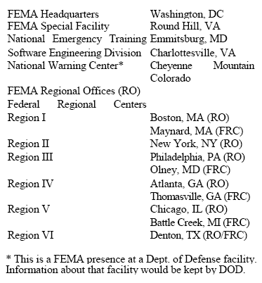
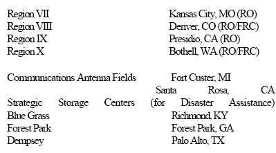
in the event of a nuclear war.
(Although FEMA is perceived as a "civilian"
federal agency, in reality FEMA and the Pentagon work closely together.)
Each of these underground bunkers is "equipped to function as an emergency
White House." The article specifically cites the FEMA "Special Facility" at
Mount Weather and the Pentagon back-up facility called Raven Rock, or Site
R, located along the Pennsylvania-Maryland border, and operated by Fort
Ritchie (see the next page for more on the Ritchie facility).
Supposedly, in
the event of a nuclear crisis, 1,000 civilian and military officials would
be rushed to these secret bunkers. They would take refuge there while the
rest of the country muddled through the ensuing radioactive holocaust as
best it could.1 In reality, given the number of secret bunkers cited (50),
it seems that the number of personnel who would be evacuated would be
considerably higher.
The logical question is: where are the underground command posts and
bunkers?
The answer is not an easy one, since by their very nature these
facilities are hard to find. To begin with, they are all underground. Some
of them are on military bases. Virtually all of them have been constructed
behind a veil of secrecy and high security. And all of them continue to
operate under considerable security.
Nevertheless, at least a partial answer can be provided, because the
locations of some of the underground bunkers are known.
And information is
also available about the function of some of them and what they contain.
THE PENTAGON - NORTHERN VIRGINIA
As might be suspected, the Department of
Defense has burrowed underneath the Pentagon, in Arlington, Virginia and
established a sophisticated facility called the "National Military
Command Center."
"SITE R" AKA "RAVEN ROCK" OR THE RITCHIE
FACILITY
In the hills of southern Pennsylvania, near
the small town of Blue Ridge Summit, is the home of the "Underground
Pentagon."
Run by nearby Fort Ritchie, since the 1950s the facility has
been a major electronic nerve center for the U.S. military.
This huge
installation, known as "Raven Rock" or "Site R," was blasted out of the
native granite known as greenstone and lies 650 ft. below the surface.
The 265,000 sq. ft. facility which sprawls beneath 716 acres is
comprised of five different buildings in specially excavated separate
caverns.
It normally is staffed by about 350 people. Access to Raven
Rock is by way of portals set into the mountainside. Its corridors are
lit by fluorescent lights and it contains a wide variety of amenities
including a convenience store; barbershop; medical, dining and fitness
facilities; a subterranean reservoir that contains millions of gallons
of water; a chapel; 35 miles of telephone lines; and six 1,000 kilowatt
generators.
"Site R" has long functioned as a sort of second Pentagon
and is equipped as a supercomputing and electronic command post linked
with numerous military communications networks all over the globe. Local
rumor has it that "Site R" is connected by tunnel to the presidential
hideaway at Camp David, several miles away in northern Maryland, near
the town of Thurmont.
According to a recent press report, with the
thawing of the Cold War "Site R" has gone to a standby status and will
be staffed at a lower level than in the past.2
THE WHITE HOUSE - WASHINGTON, D.C.
There is a large, sophisticated bunker
complex under the basement of the White House in
Washington, D.C.
Dating
back at least to the Eisenhower administration, special forces were
ready to tunnel down and extract the President from deep underground in
the event a nuclear holocaust reduced everything above to rubble.
But just how extensive - and deep - is this complex?
One source I have
personally interviewed claims that there are many, many levels below the
basement of the White House, that keep going down and down. On one
occasion during the Lyndon Johnson administration (in the 1960s), this
source was sent to deliver some papers from the Department of Housing
and Urban Development (HUD).
Upon arrival, my source was escorted by two
Secret Service agents to an elevator in an area of the White House that
is not open to the public. They entered the elevator and went down for
what the source remembers as 17 levels. When the elevator doors opened
they stepped out into a corridor covered on the walls, ceiling and floor
with beige, ceramic tiles. The corridor was very long, stretching away
in the distance to the vanishing point.
According to my source, other
corridors and doors opened off the main corridor.
The fluorescent
lighting was recessed in the ceiling. There was a man sitting at a desk
by the elevator doors. The papers were delivered to a man in a room that
opened off of the corridor and then my source was escorted back to the
elevator, back to the surface and out of the White House. All of the men
appeared to be Secret Service agents and were dressed in dark, business
suits.
The person who related this story to me had the impression there
were even more levels below the 17th level. Why papers from HUD had to
be delivered to the subterranean bowels of the White House, my source
did not know.
Whatever the actual size of this underground installation
may be, clearly there is far more to the White House than is apparent
from driving by on Pennsylvania Avenue.
KANEOHE - HAWAII
There is also an underground installation at
Kaneohe, in Hawaii, connected with U.S. Pacific Fleet operations.
CAMP DAVID - MARYLAND
At the presidential retreat in northern
Maryland, there is "an ultrasensitive underground command post" for the
use of the president in an emergency.
During the Eisenhower
administration this command post was run by a group of military officers
known as the "Naval Administrative Unit." 3
OMAHA - NEBRASKA
And at Offutt Air Force Base, in Omaha,
Nebraska, there is an underground command post for the Strategic Air
Command.4
Unfortunately, I know little more about these installations than I have
set forth here. And that's just the point - I'm not supposed to know,
and neither are you. In the event of nuclear war, we'll be nuclear
missile fodder while the President and the Joint Chiefs of Staff huddle
underground figuring out how to bounce the rubble one more time. For
that type of arrangement to work, you need secrecy, and lots of it.
In a time of nuclear war, or during some other crisis, when the
politicians and military planners go underground, where will they get
the information they need to make decisions?
Some of the most important
information will come from - you guessed it - other underground
facilities, among them the NORAD facilities described below.
NORAD AT CHEYENNE MOUNTAIN - COLORADO
For subterranean privacy, try Colorado
Springs, Colorado, where the North American Aerospace Defense Command (NORAD)
operates perhaps the best known of the major underground bases.
This super-secret facility is located deep inside Cheyenne Mountain,
outside of Colorado Springs, Colorado. Here's where the latest space,
missile, and air-traffic information is gathered, using state-of-the-art
equipment, and fed to military and civilian decision makers.
Planning for the subterranean, 4.5 acre, 15 building complex began in
1956. Construction was started in 1961. The Utah Mining and Engineering
Company of San Francisco did the excavating, under the supervision of
the Omaha District of the Army Corps of Engineers. The large engineering
firm of Parsons, Brinckerhoff, Quade and Douglas was also involved on
the project.
In 1966 NORAD moved in and began underground operations.
Jointly staffed by United States and Canadian military personnel, the
installation constantly monitors all space traffic in and around the
earth, all missile launches worldwide, submarine movements and air
defenses for North America. This NORAD base is also the National Warning
Center for the Federal Emergency Management Agency (FEMA). This is the
place from which civil defense warnings for Canada and the U.S. are
initiated.5
About 1,700 personnel operate the facility around the clock, including a
night shift of 300 people.
A 4,675 ft.
tunnel bores straight through the mountain. The entrance tunnel is 22.5
ft. high and 29 ft. wide, while the central access tunnel, that branches
off the entrance tunnel, is 25 ft. high and 45 ft. wide.
Three hundred
and fifty hardrock miners, working in three shifts, excavated almost
700,000 tons of granite to construct the facility. The NORAD base is
stocked with 30 days of contingency supplies, including enough fuel to
run its six diesel generators for 30 days. It also has underground
reservoirs, hewn out of solid rock, that hold six million gallons of
water for cooling purposes and for use by personnel for domestic
purposes.
Its 25 ton, hydraulic-operated blast doors, that open off of
the access tunnel, well inside the mountain, can open or shut in just 45
seconds. Hardened microwave channels and coaxial cables provide
essential communications links for the state-of-the-art electronic and
computer systems inside the facility.6
(See Illustration 50 for
schematic diagrams of how these communication links might look.)
NORAD AT NORTH BAY - ONTARIO, CANADA
This deep underground command center, which
is located about 200 miles north of Toronto, is also jointly staffed by
both Canadian and U.S. military personnel.
The North Bay installation
became operational in October 1963 and consists of two huge caverns,
bored out of the solid rock, hundreds of feet under the Pre-Cambrian
Shield. The two huge caverns, each 400 ft. long, by 60 to 70 ft. high
and 45 ft. wide, are connected by three cross tunnels. Inside the
caverns, just as at Colorado Springs, three-story buildings have been
constructed to house personnel and equipment.
There are two access
tunnels, the one about 6,600 ft. long and 12 ft. by 12 ft., the other
about 3,500 ft. in length and 16 ft. by 16 ft. Inside are 142,000 sq ft.
of floor space, filled with offices, communications and computer
equipment, and defense radars that cover the northern sectors of North
American air space.
There are also kitchen and dining facilities that can accommodate 400
people, a hospital and infirmary, washrooms and showers, a "well
equipped canteen," and space for people to rest and sleep. Power is
supplied by six generators that are normally fueled by natural gas piped
down from the surface. Under emergency conditions the generators would
run off of diesel fuel stored underground in the complex.
During normal
operations, water for equipment cooling and personnel use is obtained
from nearby Trout Lake. But during emergency "button-up" conditions
water would come from underground reservoirs specially excavated for use
when the facility was sealed off from the outside.
One reservoir holds
200,000 gallons for domestic use, and the other contains five million
gallons for air conditioning and equipment cooling.7
Federal Emergency Management Agency
(FEMA)
There are other secret underground
government command facilities.
Many of them are operated by
FEMA, the
Federal Emergency Management Agency. FEMA usually pops up in the news as
the lead federal agency charged with hurricane or flood relief efforts.
But FEMA has another side as well - a secret, underground side.
MOUNT WEATHER - BLUEMONT, VIRGINIA
The hub of the FEMA subterranean network is
located inside Mount Weather, near the small town of Bluemont, in
northern Virginia.
This top-secret base was constructed in the 1950s to
house the United States government in the event of a national crisis
such as nuclear war. Funded by "black" money, Mount Weather remains
nearly as inaccessible to scrutiny as it was when first built. Although
it is the headquarters for FEMA's far-flung underground empire it does
not even appear in the agency's published budget.
Security is tight at
the installation, which is surrounded by a 10-ft. perimeter fence
patrolled by armed guards. There are a few buildings above ground, but
most of the real work of Mt. Weather takes place deep below, in great
secrecy. The mountain contains what amounts to a small town.
The
infrastructure includes:
-
a small lake
-
a pair of 250,000 gallon water
tanks, capable of supplying water for 200 people for over a month
-
a
number of ponds 10 ft. deep and 200 ft. across, blasted out of solid
rock
-
a sewage plant capable of treating 90,000 gallons per day
-
a
hospital
-
a cafeteria
-
streets and sidewalks
-
a diesel powered
electrical generating plant
-
private living quarters and dormitories
able to accommodate hundreds of residents
-
a sophisticated, internal
communications system using closed-circuit color TV consoles
-
a radio
and TV studio
-
massive super-computing facilities
-
a "situation room"
equipped with communications links to the White House and "Site R" in
southern Pennsylvania
-
a transit system of electric cars that
transport personnel around the complex
According to published reports,
some of the hundreds of people who work inside the mountain routinely
stage practice drills for managing a wide variety of potential crises,
ranging from civil disturbances and economic problems, to natural
disasters and nuclear war.8
Speaking off the record, in the mid-1970s government officials stated
that, in fact, Mt. Weather houses a resident, back-up government.
Many
federal departments and agencies are represented there, including,
-
the
Departments of Agriculture, Commerce, HUD, Interior, Labor, State,
Transportation and the Treasury
-
agencies such as FEMA, the Office
of the President, the U.S. Postal Service, the Federal Communications
Commission, the Federal Reserve, Selective Service, the Federal Power
Commission, the Civil Service Commission and others
These highly placed
government sources maintain that the administrators of the Federal
departments at Mt. Weather hold cabinet-level rank and are referred to
as "Mr. Secretary" by the personnel who work under them.
These covert
"Secretaries" are said to keep their positions over the course of more
than one administration, their terms not being limited by the
presidential election cycles that govern the terms of office of their
Washington counterparts.9
These are sensational allegations, but if they
are true, then the political news we are fed in the mainstream media
must be fictional to some, unknown degree and the system governing us is
controlled to that same unknown degree by agencies and officials who
work in great secrecy, literally underground and totally unaccountable
to the citizenry of the United States.
Mount Weather serves as a hub for a system of other underground
installations and bunkers, known as Federal Relocation Centers. These
are located within a 300 mile radius of Washington, DC known as the
"Federal Arc."
Key government officials and personnel would be evacuated
to these centers in the event of nuclear war as part of the Continuity
of Government Plan (COG). Besides Mt. Weather, there are said to be an
additional 96 of these centers in Pennsylvania, Maryland, West Virginia,
Virginia and North Carolina.10
Presumably, at least some of the approximately 50 secret, underground
command posts mentioned earlier in the discussion of military facilities
would be among these 96 centers in the FEMA Continuity of Government
system.
Among other things, the centers are said to contain data files
and computer systems maintained by a variety of Federal agencies, and
are supervised by the facility at Mount Weather.11
A 1991 Jack Anderson column in The Washington Post reported that the COG
system was created by the Reagan administration and consists of a,
"$5
billion network of bunkers filled with high-tech communications
equipment at secret locations around the country."12
Just how many of
these secret centers were newly constructed during the 1980s, and how
many are older facilities that the Reagan administration merely converted
to its purposes (expanded, remodeled and modernized) is not known.
My
guess is that at least some of the dozens of secret COG facilities are
mentioned in this book.
Of course, that would leave dozens of others
which are not.
MOUNT PONY, CULPEPER, VIRGINIA
There are several underground installations
either known, or alleged, to exist in the five-state "Federal Arc" area.
The best known is probably the large bunker complex that lies under
Mount Pony, a couple of miles east of Culpeper, Virginia, just off of
Rt. 3 in the northern part of the state. Although one published report
identifies this underground facility as the emergency relocation center
for the Treasury Department, two other reports, local rumor and the sign
by the front gate identify the installation as a "Federal Reserve
Center."
Constructed in the late 1960s, the 140,000 sq ft. facility is
said to be supplied with water, food, a generator, communications
equipment and even cold-storage for corpses. One source who formerly
worked in the Culpeper area told me it is believed that the Federal
Reserve stockpiles very large supplies of United States currency there.
Indeed, 5 billion dollars are reportedly stored under Mt. Pony.
But this is not a dormant facility, waiting for Armageddon before
springing to life. From its underground vantage point in Culpeper the
Federal Reserve constantly monitors all major financial transactions in
the United
States.
It does this by means of the "Fed Wire," a modern, electronic
system that permits it to keep track of all major business and banking
activity that occurs.15
Why does
the
Federal Reserve need a secure,
underground bunker to monitor the nation's economic life?
I don't
pretend to know, but clearly, judging by the intermittent traffic going
in and out the front gate on the day I visited, the Mount Pony bunker is
in active use and doing something.
As it happens, just six weeks after my mid-June 1992 visit to the
Federal Reserve's Mount Pony bunker a cover story appeared in Time
Magazine that dealt, in part, with that very installation.
The story
said that, as of July 1992,
"the facility's mission will no longer be
needed."16
My opinion is that this may well be disinformation.
I doubt
very much that the Federal Reserve has really abandoned its bunker in
Culpeper. And even if the bunker really were to be emptied out, my
suspicion is that the contents would merely be transferred to another,
more secure location, quite likely also underground.
For what it is worth, I had spoken on the phone with the Time Magazine
article's author just a few days after visiting the Mount Pony bunker.
He wanted to know where I found my information about underground bunkers
and installations, and so I mentioned a few of the installations to him
that I knew about at that time.
FEMA IN OLNEY, MARYLAND
Another, less well known, underground
installation is located on Riggs Road, off of Rt. 108, between Olney and
Laytonsville, MD.
Although it has been reported that there are actually
two such facilities, a Federal Emergency Management Agency (FEMA) civil
defense bunker in Olney and a bunker operated by an unknown government
agency in Laytonsville,17 a recent visit to the area turned up only one
site, midway between the two towns.
If there is another
bunker in the vicinity it is sufficiently well concealed that it is hard
to spot. While it is not clear to passers-by who operates the facility
on Riggs Road, since there are only generic United States government "NO
TRESPASSING" signs posted on the security fence that surrounds the
complex, this site is reportedly the backup command center for FEMA's
day-to-day operations.18
When I arrived the gate was open and no one was
in the guard house. However, a prominently placed sign did advise that
the entrance area was under electronic surveillance. So presumably, any
unauthorized intrusion would not go unchallenged.
The one building visible from outside the fence is in an advanced state
of disrepair and gives every appearance of having been vacant for some
years. However, the real work at this site takes place beneath the
surface. One former Maryland resident who told me of the site spoke of
seeing a long line of cars heading through the gate when shifts change
and disappearing behind a slight rise in the near distance.
I did speak
with one man who had been inside the place many years ago on a school
field trip. He remembers going down two or three levels and seeing an
underground office complex and electronics facilities.
This is not
surprising given the large number and variety of aerials and antennae
visible on the surface.
Both this man and another local with whom I
spoke said that the bunker is believed to extend as deep as ten levels
underground.
THE GREENBRIAR HOTEL, WHITE SULPHUR
SPRINGS, WEST VIRGINIA
Recent revelations about a large, secret
bunker beneath the posh Greenbriar Hotel in White Sulphur Springs, West
Virginia make clear that it is entirely possible to keep the existence
of a large, underground installation out of the public eye for decades
on end.
Until the story broke in the last week of May 1992 only six
members of Congress knew that between 1958 and 1961 a warren of
living quarters, meeting rooms, and banks of computers and
communications equipment had been installed underground beneath the
hotel, located about 250 miles southwest of Washington, DC in the
Allegheny mountains.
Situated behind two giant blast doors, each
weighing more than 20 tons, and supplied with water, electricity and
sewage treatment, the complex is large enough to house eight hundred
people.
It contains,
-
a large dormitory
-
an infirmary
-
shower facilities
-
a television studio
-
radio and communications equipment
-
phone booths
and code machines
-
a dining and kitchen area
-
a power plant
-
a
crematorium for getting rid of the corpses of those who might die inside
the sealed bunker
According to published reports, the bunker was
constructed to shelter the United States Congress in the event of a
nuclear attack.19
Of course, the obvious question is:
in the certain chaos of an impending
nuclear war, how could the hundreds of members of Congress take shelter
in a distant bunker that most of them did not even know existed?
According to press reports, only a few local people, the hotel
management and maintenance staff, a handful of government officials, and
other government personnel with a "need-to-know" appear to have been
aware of the installation.
Could it be that the bunker has, or had,
another purpose which is not being divulged?
After all, if the bunker
itself was kept secret for over 30 years isn't it conceivable that there
is more to the story than has so far been publicly admitted?
FEDERAL REGIONAL CENTERS
In addition to the huge bunker at Mt.
Weather and bunkers in the neighboring states, FEMA also operates
underground installations at other sites around the country.
Reported
locations for these facilities, designated as Federal Regional Centers,
are:
-
Santa Rosa, California
-
Denver, Colorado
-
Thomasville, Georgia
-
Maynard,
Massachusetts
-
Battle Creek, Michigan
-
Denton, Texas
-
Bothell,
Washington 20
There are probably others; these are the ones that can be
identified from the public record.
I did file a Freedom of Information Act (FOIA) request with FEMA asking
where their underground facilities were located.
Even though information about underground
FEMA sites is readily available in the public domain, FEMA refused to
name them, citing national security provisions of
Executive Order 12356,
although they did list the following FEMA facilities in a letter to
me: 21
The observant reader will note that I have
already identified 10 of the facilities listed above as underground FEMA
installations.
I do not know if any of the other facilities listed in the FEMA response
to my request include an underground component. My guess is that some,
or all of them, well may. I welcome information from readers who can
tell me more.
The Defense Nuclear Agency
In 1975 the Defense Nuclear Agency published a detailed, geological
study that discussed dozens of possible sites all over the country for
very deeply based military installations - as much as 5,000 ft.
underground.22
Some of these prospective sites are relatively large in
area, while others are fairly limited in geographic extent.
Most of them are in the West; a few are
located in the mid-West and on the Eastern Seaboard. The report
delineated the sites as follows:
East
Adirondack Mountains, New York (in vicinity of Elizabethtown)
3 sites in Central New Hampshire Area to
northwest of Portland, Maine Northeastern, Central and South Central
Virginia
Mid-West
St. Francois Mountains, Missouri
(between St. Louis and New Madrid)
Northern Wisconsin (general area between
Chippewa Falls, Wausau and Florence)
Minnesota River Valley (generally 30-40 miles south of Benson and
about 50 miles southwest of Minneapolis-St. Paul)
West
Southeastern Wyoming Rio Grande River
Valley, New Mexico (to west and north of Taos; area of special
interest 20-30 miles north of Taos, near Colorado border)
Pedernal Hills, New Mexico (60-70 miles east-southeast of
Albuquerque)
Zuni Mountains, New Mexico (100 miles
due west of Albuquerque, south of 1-40)
La Sal Mountains, Utah (20 miles
southeast of Moab)
Sierra Nevada Mountains, California
(large area 350 miles long by 50 miles wide)
Idaho Batholith (large area in central
Idaho, north of Boise)
South Central Idaho (under Snake River
lava flows between Twin Falls and Idaho Falls)
Holbrook, Arizona (general vicinity)
Northwestern
Arizona (north of Seligman)
Ash Fork and Williams, Arizona (general
vicinity)
Black Mesa Basin, Arizona (under Hopi
and Navajo Reservations)
Book Cliffs-Uncompahgre Uplift. Area along Utah-Colorado border (in
general vicinity of and to south of Grand Junction, Colorado)
Monument Uplift and Blanding Basin, Utah (southeastern part of state
near towns of Blanding and Mexican Hat)
San Rafael Swell, Utah (west of town of
Green River)
Extreme West
Central Utah (area 30-40 miles west of
towns of Delta and Minersville)
Southwestern Utah (area between towns of Cedar City and Panguitch)
Nuclear Test Site, southern Nevada Central Nevada (50 mile radius of
town of Tonopah)
Northwestern Nevada (50 to 100 miles east and northeast of Carson
City)
Special Sites
Washington, D.C. (surrounding area in Virginia and Maryland)
Omaha, Nebraska (general vicinity)
Readers should bear in mind that any installations that may have been
built in these areas are likely to be well hidden, and very deeply
buried. In addition, since the areas are often rather large, the
directions provided are of necessity only a general guide to the
location of possible installations.
After all, the geological formations
of interest to the Pentagon for subterranean bases usually extend for
miles.
Also, entrances to underground facilities may be some distance
away from the base itself. So finding these places is not necessarily an
easy task.
My guess is that some of these sites have been used for underground base
construction over the last 20 years.
Readers who may have information
about the presence of underground bases at any of these sites are urged
to get in contact with me.
Deep "Black" Underground: The Oliver North
Connection
In Oliver North's autobiography,
Under Fire, he briefly mentions an
extremely secret government program called "The Project."
According to
North, for a year and a half during Reagan's first term he was the "de
facto administrator of The Project" and coordinated a group of expert
advisors known as the "Wise Men."
The work of the Wise Men and The
Project entailed providing for the survival of the United States
government in the event of a nuclear war.
North specifically says that
he wrote policy directives pertaining to The Project which President
Reagan signed, and that he also often briefed then Vice-President
George
Bush about The Project. While North does not say precisely how The
Project was carried out he does mention that the Soviet Union had "a
network of secret tunnels under Moscow" to which its leaders would flee
in time of war, while the United States had nothing comparable.23
By
implication, then, The Project would seem to have provided a similar
capability for the United States.
In fact, it seems that The Project did involve an extensive underground
construction program. In April 1994 a front page story in the New York
Times announced the existence of a previously undisclosed program known
as "The Doomsday Project."
According to the story, the project was an
"amalgam of more than 20 'black programs'" during the Reagan
administration, supervised by George Bush, with some involvement by
Oliver North. It reportedly cost some $8 billion to build and took
eleven years to complete. The Doomsday Project was concerned with the
survival of the federal government in the event of nuclear war.
The
project involved many people, including,
"White House officials, Army
generals, CIA officers and private companies."
Of direct interest for
readers of this book is the fact that the Pentagon built "scores of
secret bunkers" as part of something called the "Presidential
Survivability Support System."24
It is my educated guess that many of
these "secret bunkers" would be located in the areas and locations set
forth in previously discussed documents generated by the Army Corps of
Engineers, U.S. Air Force Project RAND and the Defense Nuclear Agency.
Last But Not Least: Underground Command
Center For Sale
And finally, this through-provoking footnote to our tour of underground
strategic command centers: As of 1992 there was a decommissioned
Strategic Air Command bunker for sale in Amherst, Massachusetts.
The
44,000 sq ft. bunker is three stories high, buried under a mountain,
blast-proof, climate-controlled, with a glassed-in command theater. It
was for sale for just $250,000.25
There are a couple of interesting
things about this piece of information.
-
First, the size and location of
this bunker underscore the fact that underground facilities and
installations can literally be almost anywhere.
-
Second, the fact that
SAC is getting rid of it on the open real estate market means that it
must be obsolete. So obsolete that they don't care who goes inside, and
they don't care who knows where it is.
One obvious conclusion would be that the
Pentagon now has something better, somewhere else.
Back to
Contents
Chapter Four
More Underground Facilities -
Military, Government, Nuclear and Business
Although I've been told that the Pentagon operates many other underground
facilities here in the United States, perhaps dozens more than I've
discussed so far, in this chapter, as in the previous chapter, I will err on
the conservative side and report only on those underground installations for
which I can provide some form of tangible documentation.
Along with military installations I also report on facilities run by other
branches of the government, and on some run by private business. Currently,
I can positively verify just seven underground corporate facilities. I
strongly suspect there are many more. I welcome information in that regard
from readers who know of other underground corporate facilities.
But whether it's the Navy or the Federal Reserve or private industry, they
all seem to have one thing foremost in their minds: S-E-C-R-E-C-Y.
ATCHISON, KANSAS
At Atchison, Kansas the Pentagon operates
(or used to operate) the Defense Industrial Plant Equipment Facility (DIPEF).
This huge underground warehouse facility, with 987,000 total square ft.
of space, is a converted and remodeled limestone mine.
The facility is
serviced by underground roadways that make it easy to move the thousands
of items of machine tools and industrial equipment stockpiled there.
Half of the underground area is paved with concrete and the entire
facility is climate controlled.
As of 1974, 138 people were employed at
the DIPEF.1
THE FEDERAL RESERVE
A 1981 Wall Street Journal article says
that,
"Nine of the 12 Federal Reserve Banks have underground emergency
quarters, where records are updated daily."
I do not know where most of
these underground emergency centers are, or how elaborate they are.
Neither do I know exactly what kind of records are kept in them.
However, since the Federal Reserve is the agency that controls national
monetary policy I would speculate that the records it keeps in these
underground centers might well have to do with the national money supply
and the daily affairs of the world of high finance.
Moreover, since we
are living in a computerized, electronic era of instantaneous
telecommunication I would speculate further that these underground
centers might contain sophisticated computing and communications
systems.
But all this is speculation on my part, since I have never been
in the Federal Reserve's underground facilities.2
NATIONAL SECURITY AGENCY - FT. MEADE, MARYLAND
Beneath the National Security Agency's
headquarters at Fort Meade, Maryland are "cavernous subterranean
expanses," said to be filled with more than ten acres of the most
sophisticated supercomputers that money can buy.3
The NSA operates in
tremendous secrecy; however, it is a safe bet based on what is known
about the agency that these computers are engaged in a massive
surveillance of much of the world's telephone, telegraph, telex, fax,
radio, TV and microwave communications, including surveillance of
domestic, internal U.S. communications by ordinary citizens.
In a word,
Big Brother is already here, and his name is "NSA."
THE DEPARTMENT OF ENERGY'S NEVADA TUNNELS AND
INSTALLATIONS
The DOE also has many underground tunnels
and installations in Nevada.
Most of the DOE activity appears to be
conducted at the Nevada Test Site (NTS), where the Department of Defense
(DOD) and the DOE have for decades been excavating tunnel complexes for
underground testing of nuclear weapons (See Illustrations 13 and 14).
These tunnel networks can be quite elaborate (See Illustration 15). The
DOE and DOD sometimes reuse the tunnels; other times they are apparently
abandoned. Their usual practice is to pack the tunnels with all sorts of
sophisticated, hi-tech equipment and machinery to monitor the blasts
(See Illustrations 16 and 17).
Much of the monitoring takes place within
thousandths of a second, even millionths of a second after the nuclear
device detonates.
I do not know the purpose of all of the hundreds of underground nuclear
blasts (a number that seems excessively high) detonated by the DOD and
the DOE; I only know that there have been many, many of them and that
there are many tunnels under the nuclear test site. I do not know where
all of the tunnels are, what they are all used for, or how extensive the
interconnections between them are, providing such interconnections exist
at all.
Like many students of UFOlogy I have heard rumors and read anecdotal
accounts that allege there are extensive underground complexes for
living and working under the Nevada Test Site. I am inclined to think
some of these accounts may be true, but I cannot provide factual
documentation that demonstrates that such facilities exist.
The DOE also
operated a test facility at the NTS in the early 1980s, deep
underground, for storing nuclear waste (See Illustration 18).
THE NUCLEAR WASTE DEPOSITORY AT YUCCA
MOUNTAIN, NEVADA
Evidently the nuclear waste storage tests in
the early 1980s were successful, or at least encouraging, because in
1991 and 1992 the DOE actively solicited companies for construction of a
deep underground tunnel complex inside and beneath Yucca Mountain, about
100 miles northwest of Las Vegas, as another "test" depository for
nuclear waste.
The actual name of the facility is the "Yucca Mountain
Site Characterization Project, Exploratory Studies Facility (ESF)."
The
solicitations were for companies that can provide:
-
tunnel boring
machines (TBMs) capable of boring tunnels of 25 ft. to 30 ft. in
diameter
-
mobile miners and other mining equipment for excavating
tunnels
-
conveyors and muck removal systems
-
underground ventilation,
water and power supply systems
-
all requisite support facilities,
buildings, roads and equipment for excavating and maintaining a major,
underground complex
Construction was slated to begin in November 1992.
Reynolds Electrical & Engineering Co., Inc., which is the Prime
Management and Operations Contractor for the Nevada Operations Office of
the Department of Energy, is the company that will supervise
construction and carry out the actual testing at the facility when it is
constructed.
The plans call for 14 miles of underground tunnels and ramps, ranging
from 14 ft. to 25 ft. in diameter, with grades as steep as - 16%. Since
the facility also is slated to contain a 1,300 ft. vertical shaft, by
implication the complex will be at least 1,300 ft. beneath the surface.
Here again, as with so much of what goes on underground, it is hard to
say what the DOE is up to. Maybe they really are making a test facility
for long-term storage (10,000 years) of nuclear waste. Or maybe the
high-security curtain of the Nevada Test Site provides a convenient
screen behind which the DOE can carry out other, more secret projects,
under the public relations rubric of a nuclear waste "test" facility.
The trail of lies at the DOE, and at its predecessor, the
Atomic Energy
Commission (AEC), is so long where things nuclear are concerned it is
hard to know when to trust the public relations rhetoric and press
releases.
The more so, since no one without a security clearance (people
like the author of this book, for instance) is usually allowed anywhere
near these facilities, let alone permitted to actually go underground to
poke around to see what is there.4
LOS ALAMOS, NEW MEXICO
At a June 1983 scientific conference in Lake
Tahoe, the Los Alamos National Laboratory (which is located in northern
New Mexico, but run by the University of California) put forward a
proposal for a "National Underground Science Facility" to be constructed
deep beneath the Nuclear Test Site in southern Nevada.
The proposal
called for the facility to be built 3,500 ft. underground, with the
possibility of extending it as deep as 6,000 ft. Initially, Los Alamos
envisioned two experimental test chambers for doing particle physics,
gravity experiments and geophysical studies. The facility would also
include machine and electronic shops, a small computer, and dormitory
space.5
Whether or not this installation was built I do not know. But,
even if it wasn't, the fact that a government agency was actively
planning to go as far down as 6,000 ft. to construct a manned scientific
facility gives an idea of how deeply based these underground
installations can be.
Most of the underground facilities I identify in
this book range anywhere from tens to hundreds of feet underground.
However, it is quite possible that there are bases that are thousands of
feet underground. Researchers and students of this subject should be
prepared to think of bases located as much as a mile or more beneath the
surface.
That may seem implausibly deep, but I promise the reader that
at the Pentagon there are planners who have commissioned studies calling
for military bases to be built as deep underground as 8,000 feet below
the surface of the earth - that's over a mile and a half down!
Those
plans are discussed later in this book.
STANDARD OIL CO. OF NEW JERSEY
As recently as 1970 Standard Oil Co. of New
Jersey operated an emergency center 300 ft. underground in upstate New
York, near Hudson. The facility was formerly known as Iron Mountain
Atomic Storage.
The site contained company records,
"vaults, dining
halls and more than 50 sleeping rooms for key company officials and
their families." 6
More recent reports indicate this facility is now
used for storage of corporate records.
NORTHROP
In the Antelope Valley of southern
California, near the towns of Rosamond, Palmdale and Lancaster are three
mysterious underground facilities, operated by Northrop, Lockheed and
McDonnell Douglas. (See Illustration 19).
The Northrop facility is
located near the Tehachapi Mountains, 25 miles to the northwest of
Lancaster. There are rumors that the installation there goes down as
many as 42 levels, and that there are tunnels linking it with other
underground facilities in the area. I do not know whether these rumors
are true or not.
There are also reports of many strange flying objects
in the vicinity, of many shapes and sizes.
Some are reportedly
spherical, others are alleged to be triangular, elongated, boomerang or
disk shaped. And they are said to range in size up to hundreds of feet
in diameter. The facility itself is engaged in electronic or
electromagnetic research of some sort. There are large radar or
microwave dishes and strange looking pylons to which various objects can
be affixed, ostensibly for the purpose of beaming electromagnetic
radiation at them.
These pylons rise up from underground out of
diamond-shaped openings in the middle of long, paved surfaces that
resemble aircraft runways, but which, in fact, are not used by aircraft.
MCDONNELL DOUGLAS
The McDonnell Douglas facility is located at
the now closed Gray Butte airport, northeast of Llano, California. It
too has "runways" that are not runways, with diamond-shaped openings
through which huge pylons with strangely shaped objects mounted on them
are raised to the surface.
These objects sometimes resemble elongated
disks or flying saucers and have been seen to glow and change colors.
Glowing spheres have also been seen by people in the area at night.
However, the nature and function of the spheres is not known.
LOCKHEED
The Lockheed installation is adjacent to
what used to be the Hellendale auxiliary airport, six miles to the north
of Hellendale, California.
Just like the McDonnell Douglas and Northrop
facilities it also has the runway-like features, with large,
diamond-shaped doors through which huge pylons rise from underground
with strange objects attached. This facility also has an obvious
underground entrance. (See Illustrations 20 and 21.)
To compound the high strangeness of these California facilities, there
are ominous reports of covert military activity associated with them,
possible alien activity (and I emphasize possible), possible abductions
and lost time episodes, and numerous sightings of extremely
unconventional aircraft and flying objects, to which I have already
alluded.7
AMERICAN TELEPHONE & TELEGRAPH
A 1981 report revealed that AT&T had seven
"emergency centers" in separate regions of the country.
At least three
of these were underground complexes. Near Netcong, New Jersey, to the
west of New York City, AT&T buried a three-story emergency center in the
granite, 40 ft. below ground.
In the center were,
"...executive living
quarters, a control room and a computer (with) the data bank for AT&Ts
entire system."
Also in the center were a,
"kitchen, a month's supply of
food for 100 people, sleeping quarters and emergency generators."
Facilities like the one at Netcong were also located at Rockdale,
Georgia and Fairview, Kansas.8 And I have been told there are others all
over the country, in isolated rural areas.
One of these underground AT&T
communications facilities is said to be located in Catron County, New
Mexico.9
In the preceding pages I have set out dozens of
known underground facilities, installations and bases.
Some of these are
quite complex and sophisticated installations, capable of supporting large
numbers of people in some degree of comfort. Some are operated by the
military, or other branches of government, and some are run by Fortune 500
companies in the military-industrial complex. I have also presented
information on dozens of other possible sites where the military was
contemplating building deep underground installations.
By now it should be clear that underground bases and installations could
literally be just about anywhere:
-
under a military base
-
under a major
hotel
-
under a prominent government building
-
under old, abandoned mine
workings
-
under virtually any mountain or hill
-
under a national park, or
perhaps in a national forest
-
in a small town
-
in the middle of a large
city - maybe even deep under an Alaskan glacier
And as the Army Corps of
Engineers documents spell out, these underground facilities could be - and
in many cases probably are - well camouflaged and concealed, making
detection by a casual observer difficult.
The purpose and function of many of these facilities appear to be related to
either the waging or the surviving of nuclear war - or both. Of course, many
other agendas and projects could conceivably be carried out in these
underground installations as well.
Let your mind run - secret scientific
research? Super-secure prisons where people are secretly detained
incommunicado? Extraterrestrial living areas?
I must confess that while I don't have many answers, at the least it does
seem certain that the southern California Lockheed, Northrop and McDonnell
Douglas facilities mentioned above are heavily engaged in nonconventional,
hi-tech aerospace research.
And while there are stories floating around in
UFO circles about bizarre, Nazi-style genetic engineering programs being
conducted in underground facilities by "Little Grey" aliens and the U.S.
military I can offer no proof that such programs exist. They may exist; they
equally may not.
As for the possibility of secret, underground prisons: I will simply observe
that many people absolutely disappear in this country every year, never to
be heard from again. No bodies are found, no trace of them ever surfaces. I
don't know where these people go; I don't know what happens to them. I can
offer no proof that any of them are held in secret underground prisons.
I
cannot even offer any proof that there are secret, underground prisons.
However, it occurs to me that at the end of WW II many German citizens were
surprised to find out that there were concentration camps, run by the Nazis,
in which millions of their neighbors (Jews, Gentiles, Gypsies, mentally
impaired, homosexuals, political prisoners) had been incarcerated, tortured,
forced into slave labor - and killed.
Given the many underground facilities secretly operated by the U.S.
government, could a similar, smaller-scale program be going on here?
I have
no proof of such a program, but considering the large numbers of disappeared
people and the existence of dozens of underground installations operating
behind a thick security veil it occurs to me that the possibility is at
least conceivable.
As I have shown, there is every reason to think that the underground
construction plans and activities of the military continued during the
1970s, 1980s and into the 1990s.
A 1974 report by
Bechtel Corporation, a huge multinational company that
derives significant revenues from government contract work, stated that,
"The demand for tunneling and underground excavation for national defense
needs is believed to be large. Some examples of underground defense
facilities include: hard-rock silos, command posts, communications systems,
personnel shelters, storage and power generation facilities." 10
And a 1981 report issued by the U.S. National Committee on Tunneling
Technology made a similar point:
"The demand for defense-related underground
construction will be affected significantly by decisions made in the early
1980s. It could be for as much as 20 million cubic meters for missile sites
and underground command posts, most of which would be constructed between
1985 and 1995. These projects do not include the civil construction
routinely carried out by the (Army) Corps of Engineers." 11
In other words, there could easily be a lot of covert construction going on
beneath our feet right now.
Back to
Contents