|

by Alexander Liskin
February
17, 2019
from
SputnikNews Website
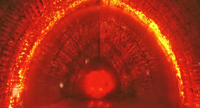
© Sputnik / Alexander Liskin
While the finding does not support
the
Hollow Earth Theory,
it does
provide some interesting insights
into geology and the history of
the Earth...
Mountains larger than Mount Everest and rougher than Tibet likely
lie deep beneath Earth's surface, a recently published study has
revealed.
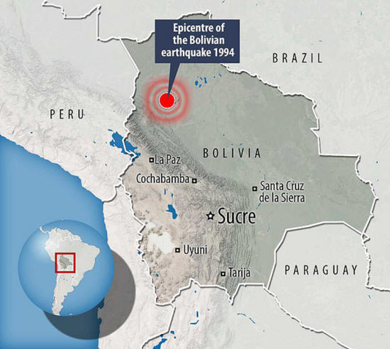
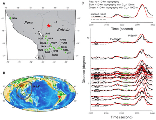
Researchers from the Institute of Geodesy and Geophysics in China
and at Princeton University in the US state of New Jersey, have used
seismic-wave data from a
1994 massive earthquake in Bolivia to
examine a layer of rock located some 660 kilometers beneath the
Earth's surface, according to Science Daily.
A very strong powerful earthquake is necessary for this type of
research, the study team noted, and the Bolivian earthquake is the
second-strongest earthquake ever recorded.
"You want a big, deep
earthquake to get the whole planet to shake," said Jessica
Irving, an assistant professor of geosciences.
According to Jessica Irving, the
earthquake had to be deep, a kind which,
"instead of
frittering away their energy in the crust, can get the whole
mantle going," cited by
Sciencedaily.com.
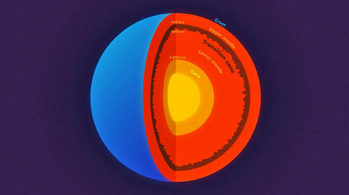
The layer of rock, whose
existence was previously known to seismologists, has no official
name and is usually referred to as the 660-km or the 410-mile
boundary.
In order to examine the
boundary, researchers used the property of waves to bounce and bend
around boundaries, Science Daily writes.
Much like people can see objects because they reflect and scatter
light waves, seismic waves are reflected from underground
inconsistencies.
Homogenous spans of rock
are transparent to such waves - similar to how glass is transparent
to our eyes, according to researchers.
The study ran the 1994 data through
Princeton's Tiger supercomputer
cluster to simulate the complicated behavior of scattering waves and
were shocked when the model revealed just how rough the underground
terrain is.
While the method does not
allow for precise measurement, researchers nonetheless believe that
the underground anomalies are of much larger dimensions than on the
surface.
"In other words, stronger topography than the Rocky Mountains or the
Appalachians is present at the 660-km boundary," noted research
collaborator Wenbo Wu.
"They find that
Earth's deep layers are just as complicated as what we observe
at the surface," said seismologist Christine Houser, an
assistant professor at the Tokyo Institute of Technology who was
not involved in the study.
"To find 2-mile (1-3 km) elevation changes on a boundary that is
over 400 miles (660 km) deep using waves that travel through the
entire Earth and back is an inspiring feat," Houser noted.
The team's finding
provides better insight into the structure of Earth's mantle,
Science Daily writes.
For years, scientists debated the importance of the 660-km boundary
and whether it influences thermal convection inside our planet.
Earlier observations have suggested that the two layers of the
Earth's mantle are either chemically homogenous or chemically
dissimilar.
New research results may
bring those divergent observations together and provide insight into
processes that have led to the mantle's current state.
Huge Earthquake in Bolivia reveals...
Vast Underground Mountain Range
...bigger than
anything on Earth's Surface
by Strange Sounds
February
16, 2019
from
StrangeSounds
Website
Scientists were able to determine the roughness
at the top and bottom of the transition zone,
a layer within the mantle, using scattered earthquake waves.
They found that the top of the transition zone,
a layer located 410 kilometers down, is mostly smooth,
but the base of the transition zone, 660 km down,
in some places is much rougher than the global surface average.
"In other words, stronger topography than the Rocky Mountains
or the Appalachians is present at the 660-km boundary."
Classic sci-fi writer Jules Verne once imagined a whole subterranean
landscape deep inside the planet, complete with lost prehistoric
species and plant life.
The book was aptly titled
Journey to the Centre of the Earth.
Now, a new research is revealing
features in the underworld resembling structures on the surface.
Far from a bubbling hot
mess, there are mountains deep below rivaling anything up here… Yes,
there's a chance that these mountains are bigger than anything on
the surface of the Earth.
So taller than the
Everest...!
Geophysicists from
Princeton University in the US and the Chinese Academy of Sciences
used the echoes of a massive earthquake that struck Bolivia two
decades ago to piece together the topography deep beneath the
surface.
The earthquake
On 9 June 1994, an 8.2 magnitude tremor rocked a sparsely populated
region of the Amazon in Bolivia.
Nothing this powerful had been seen
in decades, with shocks being felt as far away as Canada.
"Earthquakes this big don't come along very often," says
geoscientist Jessica Irving.
Not only was it big, it was deep, with a focal point estimated at a
depth of just under 650 kilometers (about 400 miles).
Unlike quakes
that grind through the crust, the energy from these monsters can
shake the whole mantle like a bowl of jelly.
Using wave data
from
a 8.2 magnitude earthquake in Bolivia,
mountains
were discovered at the transition zone
in
layer in Earth Mantle.
The tremor happened to be
one of the first to be measured on a modern seismic network,
providing researchers with unprecedented recordings of waves
bouncing through our planet's interior.
So what?
Just like the soundwaves from an ultrasound can reveal differences
in the density of tissue inside a body, the huge waves pulsing
through Earth's molten guts as its crust shudders and grinds against
itself can be used to put together an image of what's down there.
Only recently geoscientists used signatures in these waves to
determine the rigidity of the planet's core.
In this instance, the researchers took advantage of the 1994 quake's
intensity to detect waves scattering as they transitioned between
layers, revealing details of the boundaries.
"We know that almost
all objects have surface roughness and therefore scatter light.
That's why we can see
these objects - the scattering waves carry the information about
the surface's roughness," says lead author Wenbo Wu, a
geoscientist at the California Institute of Technology.

Topography
above and below the transition zone.
via Science via Google
"In this study, we investigated scattered seismic waves
travelling inside the Earth to constrain the roughness of the
Earth's 660 kilometer boundary."
At this depth there's a
division between the more rigid lower parts of the mantle and an
upper zone that isn't under quite as much pressure, one that creates
a discontinuity marked by the appearance of various minerals.
The deepest hole we've ever dug is a paltry 12 kilometers (7.5
miles) deep, so without a Jules Verne scale tunnel to drop us down
there, we've had no idea what this transition zone looks like.
Until
now...
The transition
zone and implications
Based on those all-important waves coursing through the boundary,
the researchers have concluded the meeting point between the
mantle's upper and lower parts is a zigzagging mountain range that
puts anything on the surface to shame.
"In other words,
stronger topography than the Rocky Mountains or the Appalachians
is present at the 660 kilometer boundary," says Wu.
Their statistical model
didn't allow for precise height determinations, but there's a chance
that these mountains are bigger than anything on the surface of the
Earth.
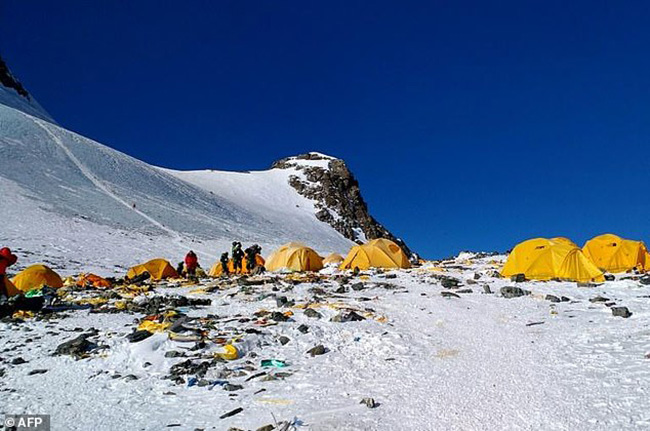
An underground mountain range
has been discovered that lies
410 miles beneath the Earth's surface
that's taller than Everest (pictured),
and possibly than any structure on Earth.
via AFP
This jagged line has significant implications for Earth's formation.
Most of our planet's mass
consists of mantle, so knowing how it mixes and changes by
transferring heat informs us of how it evolves over time.
Different takes on the evidence have produced competing models on
how minerals flow and churn within the pressurized rock, some saying
it's well-mixed, others suggesting there's interference at the
border.
Earthquake waves show similar patterns…
A huge
mountain range was discovered underground.
By
Science via Google
Knowing the details of
this subterranean mountain could decide the fate of various models
describing the history of our planet's ever-changing geology.
"What's exciting
about these results is that they give us new information to
understand the fate of ancient tectonic plates which have
descended into the mantle, and where ancient mantle material
might still reside," says Irving.
It might not be an easy
place to explore. And forget the mastodons and giant insects.
But the lost world under
our feet still holds clues about our past if we know where to look.
Video
|