|

by Scott Corrales
from
GreyFalcon Website
Doubt of the real facts,
as I must reveal them, is inevitable; yet if I
suppressed what will seem extravagant and incredible
there would be nothing left.
~H. P.
Lovecraft
The inspiration for this article began
in the summer of 1996, when a series of email messages began to
appear suggesting the possibility that “someone” or “something” was
surreptitiously removing all recent maps of Antarctica.
The notion
was so outrageous that even die-hard conspiracy theorists found
themselves having to clarify the subject - it wasn’t that Big Brother
and his henchmen were ripping map pages out of every World Almanac
and atlas in the country, it had merely become harder to obtain
recent maps on Antarctica.
Intrigued by the electronic statements, I placed a call to
Penn-Oh-West Maps in Pittsburgh to check on the availability of
Antarctic projections. The storeowner’s response was startling:
“Sorry, sir. All our new maps of South Pole are on back order. Must
be some kind of problem with the USGS.”
The United States Geological Service, or
USGS, produces the most
detailed maps available, such as the 7.5-minute series topographic
maps at a 1:20,000 scale.
Nor is the USGS planet-bound - their
expertise extends to detailed maps of the Moon, Mars, and Venus.

Antarctica has nearly 90% of the ice and 70% of the fresh water on
Earth.
The third-largest continent, it is one and a half the size of
the US.
Nations including the United States, Britain, Australia, New
Zealand, France and Argentina
carry out experiments at bases dotted
across the continent.
|

ALH 84001 was found in Antarctica during the 1984-1985 Antarctic
summer.
It was found by a team of meteorite hunters from the ANSMET
program, which is sponsored by the Polar Programs Office of the U.S.
National Science Foundation. ANSMET stands for ANtarctic Search for
METeorites, and has been funded since 1977 by the NSF.
It is nearly certain that ALH 84001 is from Mars, even though people
have never been to Mars and no rocks have ever been collected on
Mars. In fact, there are 11 other meteorites, called the SNCs, that
are also almost certain to be from Mars.
The strongest evidence for
their Martian origin is that they, including ALH 84001, contain
traces of gas that is just like the Martian atmosphere. We know the
composition of the Martian atmosphere, because the Viking Lander
spacecraft analyzed it, on Mars, in 1976. The Martian atmosphere is
really different from the Earth’s atmosphere, or Venus’, or any
other source of gas that has ever been found.
To get off Mars, ALH84001 must have left its surface going faster
than Mars’ escape velocity, about 5 kilometers per second (about
11,000 miles per hour). The only known natural process that can get
rocks moving so fast is meteorite impact - volcanoes can not throw
rocks fast enough.
If a large enough meteorite or asteroid hit Mars,
some rocks nearby on Mars’ surface would be blasted up faster than
the escape velocity and could leave Mars completely. The best
estimates are that an asteroid bigger than about 1/2-2 kilometers
could launch rocks like ALH 84001 off Mars and into space.
After it left Mars, ALH 84001 orbited the Sun on its own, like a
small asteroid. It started out with an orbit nearly like Mars’. But
its orbit changed each time it passed close to Mars or collided with
an asteroid. Also, gravity from the planets (especially from
enormous Jupiter) slowly nudged ALH 84001 farther and farther from
Mars.
By chance, the orbit of ALH 84001 changed enough so that it
came near the Earth's orbit. 13,000 years ago, the Earth and ALH
84001 collided.
New Antarctica
Mystery
A new meteorite that came from Mars has been
discovered by US scientists in Antarctica, the US
space agency NASA announced.
The meteorite was found by a field party from the US
Antarctic Search for Meteorites program (ANSMET) on
December 15, 2003, on an ice field in the Miller
Range of the Transantarctic Mountains, roughly 750
kilometers from the South Pole.
The 715.2 gram black rock, officially designated MIL
03346, was one of 1,358 meteorites collected by
ANSMET during the 2003-2004 austral summer, said the
National Aeronautics and Space Administration.
Scientists at the
National Museum of Natural History involved in
classification of Antarctic finds said the
mineralogy, texture and the oxidized nature of the
rock are unmistakably Martian.
The new specimen is the seventh recognized member of
a group of Martian meteorites called the nakhlites,
named after the first known specimen that fell in
Nakhla, Egypt, in 1911.
Nakhlites are thought to
have originated within thick lava flows that
crystallized on Mars approximately 1.3 billion years
ago and sent to Earth by a meteorite impact about 11
million years ago.
afp
Daily Times for July 22, 2004
"Piece of Mars found in Antarctica"
This leaves unanswered the question of how this rock crossed 52
million miles of space and arrived on Earth.
Maybe a UFO landed on
Mars, and the rock became lodged in its landing gear. Later, as the
saucer was making its final approach into an alien base in
Antarctica, the rock came loose and landed in the ice field.
In
short, the rock came to Earth the same way the dandelion came to
North America - by ship.
|
Reflecting on the situation, I thought that the changes on the
seventh continent are so few that they hardly justify the creation
of new maps.
If someone desperately needed a map of the South Pole,
it would suffice to resort to a National Geographic map or to the
nearest Rand McNally atlas. But could the polar conspiracy theorists
be onto something?
The matter of polar cartography was soon forgotten - at least for
me - until in 1999, the media trumpeted news of a truly sensational
discovery: a lake whose waters had never seen the light of day, at
least not for millions of years, a few miles beneath the polar
icecap.
The new body of water was christened with the name of the
Russian experimental station located immediately above it: Vostok.
A Truly
Stygian Lake
The discovery of Lake Vostok was a source of almost immediate
interest for the U.S. space program, whose scientists saw in it the
chance to conduct a series of experiments foreshadowing future
unmanned missions to Europa, one of the moons of Jupiter, whose icy
surface contains lakes and deposits similar to Lake Vostok.
In September 1999, a total of 80 scientists from over a dozen
countries met at Cambridge University’s Lucy Cavendish College to
establish protocols for researching the alleged life forms teeming
in what must surely be the blackest waters in the world.
In a series
of press releases, the assembled scientists reported that the new
lake’s micro organisms would have been isolated from the rest of the
world for millions of years and therefore represented a possible
source of new antibiotics and enzymes.
British microbiologist Cynan Ellis-Evans stressed that the scarcity
of food sources, the intense pressure and darkness of the
subterranean lake, meant that finding advanced animal life at said
depths would be difficult. His comments tabled any hopes of finding
Arthur Conan Doyle’s Lost World under the Antarctic icecap.
However, undeterred by their colleague, the scientists gathered at
Cambridge drew up an ambitious research program for Lake Vostok,
including the precautions to be taken to avoid sullying the pristine
waters of the hidden polar lake. The use of a “cryobot” was
suggested: a ten-foot long device resembling a writing implement
with a hot tip.
The cryobot would descend the four miles separating
the polar surface and the lake and, upon reaching Lake Vostok, would
launch a sonar and camera-equipped “hydrobot” to explore the liquid
environment. During the ’70s, Russian scientists had managed to
drill to a depth of 3,600 meters, almost reaching the lake, whose
existence was still unsuspected.
Ice-core samples proved the existence of methane - the predominant gas
in the atmosphere of distant Europa.
Scientists and laypersons alike were thrilled by the discovery and
its space-related implications, but Lake Vostok was never mentioned
again outside specialized circles… until now.
A Continent of
Magic and Terror
The Antarctic has always represented a source of inspiration for
authors of fiction and adventure novels.
One of the most memorable
passages of Jules Verne’s 20,000 Leagues Under the Sea is the moment
when his anti-hero, Captain Nemo, unfurls his vast black flag at the
South Pole, claiming to be the first to have reached the beckoning
goal.
But it would be flesh-and-blood characters who would write the
real adventure stories of the Antarctic:
-
Shackleton’s heroic
attempts to reach the pole in a series of expeditions, none of them
successful
-
the tragic death of Robert Falcon Scott at the pole,
following the bitter discovery that Amundsen had beaten him to it by
a matter of days
-
finally, the efforts made by Vice Admiral
Robert Byrd to establish a permanent U.S. presence in Antarctica - the
research station known as “Little America”
But Antarctica always manages to escape the confines of textbooks
and appears to be bent on haunting works of fiction.
The errant
seaman of Coleridge’s Rime of the Ancient Mariner finds himself in
an Antarctic realm filled with ghosts, while master horror writer
H.P. Lovecraft, author of “At the Mountains of Madness,” describes the
polar journey made by a scientific expedition.
The trek results in
the discovery of an unknown mountain range that conceals the
existence of a nameless, ancient city built by the “Old Ones.” This
primeval, non-human species met its end at the tentacles of its own
creations: the huge and terrifying Shoggoths.
The man who seldom ventured away from his hometown of Providence,
Rhode Island, delivers a story so convincing that the Antarctic cold
chills the reader’s fingertips.
It is precisely in Lovecraft’s works that the purely fantastic
becomes uncomfortably mixed with the factual, leading us to confront
other polar mysteries of an equally ambiguous nature. Foremost among
these is Nazi Germany’s expedition to conquer “Neuschwabenland,” or
what had formerly been known as Queen Maud’s Land on most maps.
The
expedition and its goals have been the crucible for all manner of
theories - each more outrageous than the last - regarding
intra-terrestrial empires, Nazi flying saucers, and the successful
creation of “supermen” in hidden polar bases.
Conspiracy theorists
seek to bolster their speculation by referring to the sudden display
of U.S. military force in the South Pole in the years following
World War II, with the supposed aim of combating the forces
defending the last Nazi stronghold.
More recently, film spectaculars like John Carpenter’s The Thing
(1982) and X-Files: Fight the Future (1998) have employed the white
continent as a hideout for extraterrestrial forces, whether arrived
by accident or as part of a grim conquest operation, and the efforts
made by human protagonists to overcome said unknown quantities.
Possibly inspired by this assortment of sources, belief in Atlantis
has also found a new “lost continent” in which to nestle itself.
After 17 years of intense research, British authors Rand and
Rose Flem-Ath completed a work entitled
When the Sky Fell (1995). Their book did not seek to ascertain the location
of the allegedly sunken continent, but rather of other lands where
the survivors of such a catastrophe would have sought shelter.
The Flem-Ath’s studies led them to select two regions in separate
continents: the environs of Lake Titicaca in the Peru-Bolivia highlands
and Ethiopia’s Lake Tana, suggesting that both of these areas were
particularly suited for the reintroduction of agricultural
techniques in the wake of a planetary disaster.
Was Atlantis
in Antarctica?
Graham Hancock, author of
Fingerprints of the Gods (1995), has joined the Flem-Aths and other authors in supporting
controversial scientific theories regarding the displacement of
tectonic plates. As regards Antarctica, the theory suggests that the
southernmost continent was located north of the present Antarctic
Circle and could have been inhabited, featuring “a climate and
resources suitable for the development of a civilization.”
Could
these researchers have solved the riddle of the mother culture we
have come to identify with Plato’s
Atlantis?
Whether Atlantis was located in Antarctica or not, it is worth
bearing in mind the prophecies issued by
Edgar Cayce, the “Sleeping
Prophet.” Aside from performing a number of cures while in a trance
state, Cayce also gave us a series of readings regarding Atlantis
which are studied to this very day. One of them made mention of an
enormous crystal allegedly employed by the Atlanteans as a source of
energy.
Cayce predicted that said object would be rediscovered in
the late 20th century, but without specifying its location.
If the
Sleeping Prophet’s prophecies coincide with the theories put forth
by the Flem-Aths and Graham Hancock, could the Lake Vostok anomaly
be connected to the lost power source of the ancient Atlanteans?
The Magnetic
Anomaly
Early research into Lake Vostok indicated that the body of water had
a depth of 2,000 feet - far deeper than any of the Great Lakes and
half as deep as Asia’s Lake Baikal (5,000 feet) - a length of 300
miles and a width of 50 miles. Contrary to what was initially
believed, the lake received filtered light.
Further investigations
also detected the existence of geothermal sources which warmed the
lake to an astonishing 50 degrees Fahrenheit, with “hot spots” of up
to 65 degrees. Given these new discoveries regarding solar radiation
and temperature, scientists suggested the possibility that the
lake’s encapsulated atmosphere purified itself through a complex
interaction with water, and that the chances for vegetable life
forms were very good.
Research conducted by Russian scientist Ian Toskovoi - who vanished
near the Vostok station in March 2000 - on “geothermal upboiling” also
hinted at an alternative means of purification and replenishment for
the subterranean lake’s atmosphere.
Toskovoi’s geothermal upboils
were located in the so-called “ice dunes,” which appear to be formed
by thousands of bubbles of air measuring between several feet to
several hundred feet.
However, the most intriguing news coming out of Antarctica had to do
with the extremely powerful “magnetic anomaly” located in the
northern end of the lake’s coast: a discovery which would give rise
to a number of conjectures and would be compared with the fictional
TMA-1 (Tycho Magnetic Anomaly-1) in the movie
2001: A Space Odyssey.
The
electronic newspaper Antarctic Sun, which soon
became the main source of information on the Lake Vostok magnetic
anomaly, stated that during the initial flight of the SOAR (Support
Office for Aero-physical Research), aimed at conducting magnetic
resonance imaging over the area, the magnetometer recorded an
increase of 1,000 nanoteslas beyond the 60,000 nanoteslas which
characterized the Vostok Station.
Scientists had expected to find
magnetic anomalies in the range of 500 to 600 nanoteslas in areas
where volcanic material could be located, but the ranges encountered
were simply startling.
“This anomaly is so large that it cannot be
the product of a daily change in the magnetic field,” stated Michael Studinger, one of the researchers involved in the mapping endeavor.
Also significant was the sheer size of the anomaly: 65 by 46 square
miles. According to the mission’s geological team, the anomaly’s
size and severity pointed to the fact that geological changes had
taken place under the lake, suggesting the possibility that it was a
place where “the earth’s crust was thinner.”
Australian geologist Harry Mason summarized the subject thus:
“The
magnetic anomaly’s sheer size and intensity suggest the presence of
a large ultrabase component under this section of Lake Vostok at the
surface of the continental crust rock, in other words, on the old
surface prior to the ice formation.”
Using much less technical language, others noted that Mason’s
explanation matched the hypothesis suggested by Prof. Thomas Gold in
Australia’s Nexus magazine.
According to Professor Gold, the amount
of methane and exotic gases such as xenon and argon could represent
a direct threat to global climate, since they would come directly
from the Earth’s mantle using the geological features under Lake Vostok as “chimneys.”
Aside from the danger this could represent for
our planet’s embattled atmosphere, the teams of scientists and
technicians in charge of drilling through the methane dome would be
in the first line of danger, since such an operation would likely
result in a catastrophic explosion.
Two Million
Nazis
The lunatic fringe didn’t wait too long before chiming in on the
Lake Vostok situation.
The most outrageous rumors emanated not from
the U.S. but from Australia, where a website (Fortress Australia
Outpost)
indicated - or ranted, more properly - that the total population of
Nazis in Antarctica now exceeded two million and that many of them
had undergone plastic surgery in order to move about with greater
ease through South America and conduct all manner of business
transactions.
Conspiracy theorists stoked the fire by saying that
the polar Nazis had successfully stolen an intaglio press to forge
dollars, in addition to having forged “virtually undetectable”
pounds sterling. The monetary needs of the polar Nazi community were
further supplemented by “the gold stolen during the war and their
ability to transmute base metals into gold.”
It was only logical,
they argued, that the mystery of Lake Vostok was also directly
related to the nefarious activities of the polar Nazis.
The strange writings of the author known only by the surname
“Branton” also resurfaced, especially one set of documents alleging
that the Nazis had managed to build flying saucers and transfer them
to Antarctica in 1944, and that the Nazi bases in the South Pole
also included groups of renegade Pleiadans and Men in Black.
A digression becomes necessary at this point: While the odds that
Pleiadans and MIB are cooling their heels at an underground
Antarctic base are slim to none, there is a factual basis to claims
involving Nazi Germany’s interest in the South Pole. In 1938, the
hydroplane carrier Schwabenland left the German port of Hamburg for
Antarctica, commanded by Albert Richter, a veteran of cold-weather
operations.
The Richter Expedition’s scientists used their large
Dornier airboats to explore the polar wastes, emulating Adm. Richard
Byrd’s own efforts a decade earlier. The German scientists
discovered ice-free lakes with traces of vegetation and were able to
land on them. It is widely believed that the Schwabenland’s
subsequent visits to the pole were aimed at scouting out a secret
base of operations on the White Continent.
A suitable location was
found at the Hlig-Hoffman massif, which was hollowed out into a
facility known only as “Base 211.”
In 1947, Admiral Byrd would lead a task force of 13 surface ships
and 4,000 soldiers to Antarctica as part of
Operation Highjump.
Although the expedition’s avowed intention was the testing of
military hardware under extreme conditions, the suggestion that it
was a combat operation aimed at dislodging Nazi troops from their
last redoubt has always floated in the air.
At one point the torrent of email messages regarding Lake Vostok
suggested the belief that almost everyone was involved in the
mystery (First Lady Laura Bush was allegedly in charge of
coordinating shipments of “unknown artifacts” headed for the
Antarctic) and that the mystery also involved a UFO. Other remarks
indicated that four experts in Antarctic mountaineering had been
sent to Lake Vostok as part of a “secret mission.”
In early March 2001, a U.S. channeler known as Lady Kadjina replied
to a series of questions regarding the mystery of Lake Vostok.
Regarding the nature of the magnetic anomaly, she declared that long
before the Antarctic became icebound, the continent had been used as
a landing site by extraterrestrials.
|
Lady Kadjina
March 1, 2001
from
ShastaPortal Website
Why is Magnetic Anomaly at
Lake Vostok Being Guarded by National Security Agency?
Wayne: There has recently been posted information about
a magnetic anomaly in the Antarctica in the Lake Vostok
region (http://www.cyberspaceorbit.com/antmag.html)
with the implication that this area is being guarded by
the National Security Agency.
Can you tell us what the
implications of this magnetic anomaly are?
Good morning. Enough of the ice cap has melted in this
region to allow for the emitting of a certain signal.
Before there was ice, there was land and there was a
large landing port for extraterrestrial craft.
And the
extraterrestrials put up something comparable to
what you would call an observatory. It contained a
signaling device that could transmit frequencies in a
coded pattern. Even after the ice cap began forming, at
this end of the lake there was still an entranceway into
the inner regions of the earth. Now this inner region is
not completely underground.
It is under ice, but not
totally under ground. But with the melting of the polar
cap, the signaling device has been picked up. And as
planetary grid systems are reconnected with great earth
crystals, and being that the technology of this
observatory is based upon crystal technologies, its
signal has been amplified. It is of a sonar-type of
frequencies and has a certain similarity to Tesla
technologies and the Rife technologies, but is
considerably more advanced than your understanding of
these technologies.
And these technologies, to
those in outer space, would be equated to a homing
device. When a sonar energy is emitted, it goes out in
wave-like patterns and this is what is giving wave-like
patterns to surrounding areas of snow.
Over the next several months, more and more bases like
this will be discovered. And the various governments are
going to want to seize control. It used to be that
governments wanted to seize control of those things
going on in space, but so much is now being discovered
upon Planet Earth that governments are acting quickly to
secure and lock up certain areas that contain
information that would rewrite all of your histories and
require tremendous rethinking on the part of many.
When you take a look at
all of the information that has come forth in just the
last several months (civilizations in Peru and parts of
Europe, the Mediterranean, the Pyramids, the Grand
Canyon, Florida, New Mexico, Missouri, Virginia). And
then on top of this you have your visionaries who are
able to see great domes over areas of the Biminis, over
areas of Washington. And then again you have the
mysteries of the orbs and all of these things are not
the doings of overworked imaginations; they are very
real.
As more and more of you develop 4th and 5th dimension
vision and hearing and mind, you will begin to see great
devas in your mountains, over your lakes and oceans,
communications with the fairy people will become
commonplace and they will give forth much information as
to the parcels of land that are safe to live upon and
those that have energies that need clearing before
construction. And all of this information that is coming
forth has frightened your world leaders, who are bent
upon control. They are losing their grip.
I will divert into another topic concerning the
chemtrails. It has long been a practice in your mental
hospitals to give everyone heavy medications as a way of
controlling them. You are doing this with your young
people by giving the Ridalin instead of answering and
addressing their legitimate concerns, you are in fact
sitting on them.
And this is part of what is being done
with the chemtrails. There are too many people asking
too many questions, divert them; give them enough of
something to make them ill enough so that their
attention is diverted and they no longer ask questions.
It is a fact that
ingestion of chemicals creates an impingement upon the
soul’s ability to maintain control over its physical
vehicle. And this is the reason for the heavy snows and
the floods and the changes in wind currents that are
sudden and dramatic and that help clear the atmosphere
and set free the people so that they can continue to
question and think.
Wayne: What is actually creating the magnetism at the
Vostok site?
It is that observatory. There are huge crystals that are
emitting certain types of magnetic emissions and this
creates the homing device. It is a similar type of
energetic to that which is transpiring in Bimini, where
the energy can actually draw into itself crafts and
ships and sink them. It used to be that great
spacecraft, not quite the size of a mother ship, but of
a cargo ship, would have equipment that would be lowered
into this region on a magnetic beam somewhat like a
magnetic elevator.
And from this region the
equipment would be disbursed as needed to other
locations. These magnetic beams could transport heavy
items to far distant places and energize those objects
somewhat like the operation of a hover plane, not
precisely the same, but similar.
And this gives a little bit of an insight into the
construction of some of your pyramids and other massive
edifices such as the great sphinx. For this
magnetic-sonar system also can emit sound, both audible
and silent. So you may ask, how can sound be silent?
It is of a frequency
beyond the range of the human ear. And so your Secret
Service is wanting to harness this energy for their own
purposes. They think it can be beamed to your Telstar or
other objects in space. They also believe that it can be
used as a weapon of destruction if need be. So they are
hoping to reactivate this equipment.
They will not be allowed
to do so beyond a certain point.
Wayne: Is this magnetic anomaly and the entrance into
the underground realm at this location related to
Admiral Byrd’s experience of going into the inner earth?
Yes indeed, and when he did, he found himself in a
totally different dimension, for these are also portal
type of energies. The purpose of these great
observatories, and they were much more than that, was to
create time and space warp zones for the admitting of
craft which were of a 5th dimensional frequency. With
full knowledge of this equipment, a human could
time-travel and access information stored in many
distant places.
But you will be prevented
from doing this until such time as governments have an
arms treaty in place and become of a more peaceful state
of being.
Wayne: Is this portal used today for entering/exiting
craft that have been seen going up and down west coast
of South America?
This particular site can be used as a refueling station,
if you would. Many of the craft, especially the small
ones, function from a magnetic standpoint. And it would
work somewhat like the need to recharge a fuel cell in
some of the vehicles you have now, or refueling your
electric cars.
Many craft operate on
magnetic energy systems and these magnetic energy beams
can serve to refuel or recharge many of these craft. The
“portal” is not on the earth plane, but is created in
the atmosphere where it allows for admission of beings
and craft from other dimensions.
We have mentioned before that the nadial connectors are
on the earth plane. But they are also out in the galaxy
as well. And these nadial connectors are also portal
entrances to access the next connecting point.
If you recall we spoke of
these nadial connectors being somewhat like Tinker Toys
so that when you connect with one of these nadial hubs,
you then would follow a certain energy pattern to the
next connector.
|
The ever-benevolent aliens
built what we would call an observatory, explained the channeler,
equipped with a signaling device capable of broadcasting coded
messages.
More and more such observatories would be discovered in
coming months, and Earth governments would try to seize them. Lady Kadjina added that the observatory contained vast crystals which put
forth a certain kind of magnetism, which had been employed as a
guidance system so that large spaceships could land at that
location.
But that wasn’t all: the magnetic anomaly also served as a port of
entry to other dimensions. Vice-Admiral Byrd had apparently stumbled
into one of them and had radioed back reports of seeing a completely
different, verdant landscape under his aircraft.
With proper knowledge of this equipment, a human being would be able
to travel in time and access information stored in distant places.
But we will be kept from doing so until our governments have put
aside the arms race and reach a more peaceful level of co-existence.
The
Interrupted Press Conference
“Good morning. Could I speak with
Debra Shingteller?”
“Of course, one moment,” replied the switchboard operator at
NASA headquarters in Washington, D.C.
This was my second attempt at contacting
the protagonist of the extremely bizarre press conference allegedly
held by NASA regarding its involvement, or rather, the sudden end of
its involvement, in the Lake Vostok project.
It appeared that the agency’s budgetary
cuts had been so severe that not even background music could be
heard while I was on hold.
“I’m sorry, sir. She’s not in at the
moment.”
“Ah...could you please give me her voicemail?”
“Of course. Hold on, please.”
Although I doubted that the elusive Ms.
Shingteller would actually return my message, I thought that it was
still worth a try.
I was surprised, however, when the voice on the
answering machine did not correspond to that of the spokesperson,
but to another functionary of the NASA Public Information Office. It
would appear that Ms. Shingteller had taken some time off after the
conference that would make her a household name in conspiracy
circles around the world.
My question, in any event, was
straightforward: why didn’t the press release regarding the sudden
distancing of NASA and JPL with the Lake Vostok project appear among
the ones publicly available on the web (www.nasa.gov)?
The communiqué which had vanished from the electronic medium would
have read thus:
“ANTARCTIC CARTOGRAPHIC MISSION INTERRUPTED DUE TO
N.S.A. OVERRIDE,” adding that NASA spokesperson Ms. Shingteller had
alluded to “matters of national security” which necessitated the
termination of both space exploration agencies’ involvement in the
research initiatives at Lake Vostok.
After saying these words, the
spokeswoman was escorted from the podium while her assistant
responded to the inevitable questions from the press core with a
rote sentence:
“The project has been cancelled due to environmental
reasons.”
Shortly after this event, JPL’s Frank D. Carsey tried to put an end
to the rumors by saying that the wrong acronym had been employed,
and “NSA intervention” should have been “NSF intervention,” given
the National Science’s Foundation assumption of the NASA’s drilling
operations, arising from the fact that the space agency’s funds had
been exhausted.
This did nothing to allay the mystery.
Word spread over the Internet that researchers stationed at Norway’s
Amundsen base, 150 miles east of Vostok, had witnessed the arrival
of a large quantity of equipment and personnel in the study area.
Australian sources remarked that the two women who had taken the
challenge of crossing Antarctica by skiing from one end to the other
had been forcibly evacuated.
Apparently both skiers had been
transferred to the Australian polar base and from there to Samoa by
an elite U.S. Marines unit, despite the protests of Australian
personnel.
Another rumor held that Russian scientists had been
evicted from the Vostok base by U.S. Navy SEALS (what must Vladimir
Putin have thought about all this?) while an exodus of personnel
from the U.S. bases was underway: Seven individuals, all of them
employed by Raytheon, which provides support services for the
American polar bases, were evacuated for medical reasons, while
another four departed from the McMurdo base voluntarily.
According to statements made on the Art Bell Show, two of departees
from the South Pole were suffering from an ailment about which they
refused to comment.
Much was made about a comment voiced by the
physician in charge at McMurdo to the medical officer who was coming
in to replace him:
“Fill your pockets with salt”
- apparently a
phrase commonly employed in the nuclear industry referring to the
taking of iodine tablets in order to prevent any harm to the thyroid
gland in the event of a nuclear crisis.
Even more startling was a statement posted on the Internet and
attributed to Mike Bara, who coordinates the
Enterprise Mission’s
“South Pole Update.”
The statement supposedly suggested that the
short supply or complete lack of salt at the South Pole at the end
of the Antarctic summer, at a time when sufficient quantities ought
to be found after seasonal revictualing, suggested the possibility
that the salt was being consumed by workers due to high levels of
radioactivity - suggesting the possibility that the source of Lake Vostok’s heat could have been
radioactive in nature.
Conclusion
Lest the reader be given the idea that the Antarctic has a monopoly
on mystery, a visit to the lands surrounding the Arctic Circle may
be in order.
In his book
Atlantis Rising (1976), renowned paranormal and
UFO researcher Brad Steiger mentioned a 1965 paper presented by
Canadian geophysicist John M. DeLaurier of the Dominion of Canada
Observatory. According to this scientist, there was something
strange going on beneath the ground at Ellesmere Island, a barren
location mostly covered by glacial icecap and roamed by herds of
caribou and musk oxen.
Professor DeLaurier’s paper discussed the existence of a structure
so vast that it defied imagination - a quasi-cylindrical loaf of an
object measuring 65 miles long by 65 miles thick at a staggering
depth of 80 miles.
The huge structure had been detected by seismic
equipment located at Alert, one of the U.S.-Canadian Distant Early
Warning (DEW) stations in the Arctic wilderness.
Studies showed that
the object, which straddled the earth’s mantle and crust, was the
source of some sort of disturbance - similar to the situation
encountered at Lake Vostok 30-odd years later - affecting the magnetic
field at the Alert facility and “inducing a strong flow of
electricity.”
Official sources have not provided much additional information
regarding the mysterious Antarctic lake, and the controversy rages
on across the Internet, while hundreds of different opinions clash
over the nature of the goings-on at this remote location.
|
Some people believe there is a base built under the Antarctic ice to
house up to 2 million people.
It is thought that towards the end of the Second World War the Nazis
moved to Antarctica and that they began to construct a base there.
It was to be manned by mostly SS men. As the allies got closer and
closer to Berlin, Hitler was moved out to this Arctic base.
The location of this base is said to be Lake Vostok. This lake,
about the size of Lake Ontario, is about 2km below the surface ice.
It contains life forms that are not known anywhere else on the
planet and is at a relatively comfortable temperature of between 50
and 65 degrees Fahrenheit. Not bad considering the surface
temperature is about -60 degrees F.
In 1998 NASA and JPL were involved in a scientific operation to
drill into and explore Lake Vostok. Their stated objective was to
train astronauts for future missions to the frozen moons of Jupiter.
It seems that in 1998 the chances of any manned craft getting to
Jupiter in the life time of the men being trained was not very
likely.
In February, 2001, all drilling and scientific work at Lake Vostok
was abruptly ceased. NASA and JPL stated that they were vacating the
area and abandoning their research. They just up and walked away
from billions of dollars worth of equipment. Why? Because they were
concerned about damaging the natural environment. Since when has
NASA had a 'Green' conscience? However, they didn't leave the base
unattended.
As they walked out, the NSA walked in.
Many other strange events happened around the same time.
Extraordinary and unprecedented emergency airlifts were made to
evacuate ill personnel during the dead of the six-month winter.
Scientists discovered massive magnetic anomalies beneath the ice at
Lake Vostok. Three of those same scientists died in 'accidents'
before they could leave Antarctica. Another technician apparently
"became insane" and was evacuated to New Zealand. This is after the
hitherto lucid, rationally-minded man publicly broadcast news of
large UFO's at McMurdo Base.
What could have caused them to stop?
One site believes that a
civilization from
Mars is below there. It’s just as likely this
could be the Nazi base that was constructed in the war.
UFO Over
Antarctic - Stops, Goes, Maneuvers
In official public statements, Argentina and Chile have solidly
nailed down the existence of UFO color pictures taken at their
Antarctic scientific stations. Adding to earlier press stories, the
Secretary of the Argentina Navy confirmed these details:
“On July 3, 1965, a giant lens-shaped flying object was seen,
tracked and photographed at the Argentina scientific base, Deception
Island, in the Antarctic. Lt. Daniel Perisse, C.O., confirmed by
radio that the large UFO alternately hovered, then accelerated and
maneuvered at tremendous speeds. While being tracked by theodolite
and watched through binoculars, the unknown object caused strong
interference with variometers used to measure the earth's magnetic
field, and also registered on magnetograph tapes. Color pictures
were taken through a theodolite by a member of a visiting group from
the Chilean scientific base.”
Also confirming these points, the Chilean Minister of
Defense at
Santiago added new information radioed by Cdr. Mario Janh Barrera,
C.O. of the Chilean base:
"On June 18, a similar UFO had
maneuvered
over the area, seen by all personnel. During the July 3 sighting,
the strange object had caused strong radio interference, temporarily
blocking his attempts to report the UFO to the English and Argentina
bases."
It would seem something is going on down there, but what?
|
At The
Mountains Of Madness
The pace of shrinkage of Antarctic glaciers has been accelerating.
Especially during the past five years has the shrinkage been rapid.
Antarctica is a continent, an enormous land area covered by ice. As
its snowy cover disappears, what might this continent reveal? Easter
Island-type statues? Stonehenge-type ruins?
This farthest southern land has long been a blank slate inviting
speculation. In Edgar Allan Poe's strange novel, The Narrative Of
Arthur Gordon Pym Of Nantucket, the adventurer finds that, beyond a
certain latitude, the climate begins to get warmer!
This echoes
claims in a later book,
The Hollow Earth, by Dr. Raymond Bernard. Dumbrova, a Russian explorer, is therein quoted as referring to,
"The memorable December 12th discovery of heretofore unknown land
beyond the South Pole by Capt. Sir George Hubert Wilkins."
F. Amadeo
Giannini confirmed "indeterminable land extent" at the South Pole in
his suppressed 1959 book, Worlds Beyond The Poles.
Building upon Poe's earlier work, H.P. Lovecraft told a fantastic
tale in his, At The Mountains Of Madness. An Antarctic expedition
finds a cyclopean lost city dating from before pre-Cambrian times.
Two explorers investigating weird hieroglyphics in underground
caverns encounter blind, 6-foot tall albino penguins. Unearthed is
evidence of a long-gone alien civilization, which had retreated to
the polar region.
Deep underground, a final discovery drives one of
the explorers insane and they both narrowly escape with their lives.
But pari passu with such fanciful tales arose other polar prose not
definitively fictional. With such accounts, it is uncertain where
fact ends and fiction begins. The essential guidebook to various
intriguing literature regarding Antarctica is Joscelyn Goodwin's
Arktos: The Polar Myth (1993). Mentioned is a German Antarctic
expedition to Queen Maud Land in 1938-1939 which discovered "a group
of low-lying hills sprinkled with many lakes and completely free of
ice and snow."
A later key incident was the surrender, in 1945, at
Mar del Plata, Argentina, of a German submarine, U-530. This
surrender is also covered in
Reich of the Black Sun by Joseph P.
Farrell.
Grand Admiral Karl Dönitz is reported to have stated, in
1943, that,
"the German submarine fleet is proud of having built for
the Führer, in another part of the world, a Shangri-La on land, an
impregnable fortress."
Later, at the Nuremberg trials, Admiral Dönitz boasted of "an invulnerable fortress, a paradise-like oasis
in the middle of eternal ice."
In 1946, the U.S. government proceeded with urgency to launch a
military expedition to Antarctica: "Operation Highjump". The
operation was commanded by Rear Admiral Richard E. Byrd. The
expedition "encircled the German claimed territory of Neuschwabenland (New Schwabialand)."
Following aerial reconnaissance
by Byrd and others, in which four escort craft vanished, the project
was abruptly halted.
"Byrd was returned to Washington DC, debriefed,
and his personal and operational logs remain classified to this
day..."
(Farrell, op. cit.)
But before the apparent clampdown, odd reports appeared briefly, for
example in the Chilean newspaper, El Mercurio. Farrell, in his book,
reproduces a photostat of the article, dated March 5, 1947, by Lee
van Atta, who had accompanied Byrd.
A portion of the article is
translated as follows:
Byrd announced to me today that it is necessary for the United
States to put into effect defensive measures against enemy airmen
which come from the polar regions. The Admiral further explained
that he did not have the intention to scare anyone but the bitter
reality is that in case of a new war the United States would be in a
position to be attacked by flyers which could fly with fantastic
speed from one pole to another.
Other portions of the El Mercurio article:
-
Admiral Richard E. Byrd warned today that it is necessary for the
United States to adopt protective measures against the possibility
of an invasion by hostile aircraft originating from the Polar
Regions.
-
Byrd: "The fantastic pressure with which the world is now dealing is
an object lesson learned during the Antarctic exploration now
ending."
-
The Admiral declared a necessity to remain "in a state of alert and
vigilance as the best protection against invasion."
-
Byrd's remarks are cryptic: do they warn of the need to defend
against future weapons technology or against something already
present at the time?
Iconoclastic magazine editor Ray Palmer commented on discoveries
made by Byrd, quoting him as having stated,
"We have penetrated an
unknown and mysterious land which does not appear on today's maps."
Again, the statement is either relatively mundane, or it is laced
with deeper significance.
Return now to the noncommital news that shrinkage of Antarctic
glaciers has been accelerating.
A blip on the radar screen to many;
evidence of environmental problems to some; fraught with potential
meaning to a few: Is something cooking there, at the mountains of
madness?
Piri Reis Map
Introduction
In 1929, during renovations of the old Imperial Palace in what is
now Istanbul (formerly Constantinople), a painted, parchment map,
drawn on a gazelle skin was found, dated in the month of Muharrem,
in the Moslem year 919 (A.D. 1513), and signed by an admiral of the
Turkish navy, Piri Ibn Haji Memmed, known as Piri Re'is.
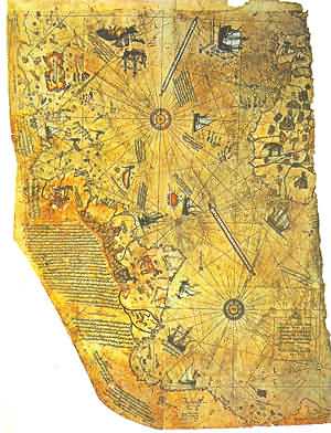
Research showed that it was a genuine document
drawn in 1513 by Piri
Reis in the sixteenth century.
His passion was cartography. His high rank within the Turkish navy
allowed him to have a privileged access to the Imperial Library of
Constantinople.
Piri Re'is own commentary indicates that some of his source maps
were from the time of Alexander the Great (332 B.C.)..
The Controversy
The Piri Reis map shows the western coast of Africa, the eastern
coast of South America, and the northern coast of Antarctica.
The
northern coastline of Antarctica is perfectly detailed. The most
puzzling however is not so much how Piri Reis managed to draw such
an accurate map of the Antarctic region 300 years before it was
discovered, but that the map shows the coastline under the ice.
Geological evidence confirms that the latest date Queen Maud Land
could have been charted in an ice-free state is 4000 BC.
On 6th July 1960 the U. S. Air Force responded to Prof. Charles H. Hapgood of Keene College, specifically to his request for an
evaluation of the ancient Piri Reis Map.
6 July, 1960
Subject: Admiral Piri Reis Map
TO: Prof. Charles H. Hapgood
Keene College
Keene, New Hampshire
Dear Professor Hapgood,
Your request of evaluation of certain unusual features of the Piri
Reis map of 1513 by this organization has been reviewed.
The claim that the lower part of the map portrays the Princess
Martha Coast of Queen Maud Land, Antarctic, and the Palmer
Peninsular, is reasonable. We find that this is the most logical and
in all probability the correct interpretation of the map.
The geographical detail shown in the lower part of the map agrees
very remarkably with the results of the seismic profile made across
the top of the ice-cap by the Swedish-British Antarctic Expedition
of 1949. This indicates the coastline had been mapped before it was covered
by the ice-cap. The ice-cap in this region is now about a mile thick.
We have no idea how the data on this map can be reconciled with the
supposed state of geographical knowledge in 1513.
Harold Z. Ohlmeyer
Lt. Colonel, USAF Commander
The official science has been saying all along that the ice-cap
which covers the Antarctic is millions of years old.
The Piri Reis map shows that the northern part of that continent has
been mapped before the ice did cover it. That should make think it
has been mapped million years ago, but that's impossible since
mankind did not exist at that time.
Further and more accurate studies have proven that the last period
of ice-free condition in the Antarctic ended about 6000 years ago.
There are still doubts about the beginning of this ice-free period,
which has been put by different researchers everything between year
13000 and 9000 BC.
The question is:
To draw his map, Piri Reis used several different sources, collected
here and there along his journeys.
He himself has written notes on
the map that give us a picture of the work he had been doing on the
map. He says he had been not responsible for the original surveying
and cartography. His role was merely that of a compiler who used a
large number of source-maps.
He says then that some of the
source-maps had been drawn by contemporary sailors, while others
were instead charts of great antiquity, dating back up to the 4th
century BC or earlier.
|

In his book,
Fingerprints of the Gods,
Graham Hancock presents
strong evidence that Antarctica was charted long ago by unknown
people, when temperatures were much warmer.
He cites a number of old maps, such as the one drawn by
Oronteus
Finaeus in 1531, reproduced here. Experts examined the original and
its age was verified. It was made in the 1500s--three centuries
before Antarctica was allegedly even sighted, much less documented.
The map is startlingly accurate, depicting ice-free mountain ranges,
a South Pole that's just about dead on and the Ross Sea as it would
look without the ice shelf.
You can even see Ross Island.
How could someone draw such a map more than 200 years before Capt.
James Cook even sailed south of the Antarctic Circle?
Hancock's answer is that it was actually mapped long ago, perhaps
thousands of years earlier, and Finaeus merely copied those ancient
sources.
|
Dr. Charles Hapgood, in his book
Maps of the Ancient Sea Kings
(1979), said that:
It appears that accurate information has been passed down from
people to people. It appears that the charts must have originated
with a people unknown and they were passed on, perhaps by the
Minoans and the Phoenicians, who were, for a thousand years and
more, the greatest sailors of the ancient world.
We have evidence
that they were collected and studied in the great Library of
Alexandria (Egypt) and the compilations of them were made by the
geographers who worked there.
Piri Reis had probably come into possession of charts once located
in the Library of Alexandria, the well-known most important library
of the ancient times.
According to Hapgood's reconstruction, copies of these documents and
some of the original source charts were transferred to other centers
of learning, and among them to Constantinople.
Then in 1204, year of
the fourth crusade, when the Venetians entered Constantinople, those
maps begun to circulate among the European sailors.
Most of these maps - Hapgood goes on - were of the Mediterranean and
the Black sea. But maps of other areas survived. These included maps
of the Americas and maps of the Arctic and Antarctic Oceans. It
becomes clear that the ancient voyagers travelled from pole to pole.
Unbelievable as it may appear, the evidence nevertheless indicates
that some ancient people explored Antarctic when its coasts were
free of ice.
It is clear too, that they had an instrument of
navigation for accurately determining the longitudes that was far
superior to anything possessed by the peoples of ancient, medieval
or modern times until the second half of the 18th century. [...]
In 1953, a Turkish naval officer sent the Piri Reis map to the U.S.
Navy Hydrographic Bureau.
To evaluate it, M.I. Walters, the Chief
Engineer of the Bureau, called for help Arlington H. Mallery, an
authority on ancient maps, who had previously worked with him.
After a long study, Mallery discovered the projection method used.
To check out the accuracy of the map, he made a grid and transferred
the Piri Reis map onto a globe: the map was totally accurate. He
stated that the only way to draw map of such accuracy was the aerial
surveying: but who, 6000 years ago, could have used airplanes to map
the earth??
The Hydrographic Office couldn't believe what they saw: they were
even able to correct some errors in the present days maps!!
The precision on determining the longitudinal coordinates, on the
other hand, shows that to draw the map it was necessary to use the
spheroid trigonometry, a process supposedly not know until the
middle of 18th century.
The way the Piri Reis map shows the Queen Maud land, its coastlines,
its rivers, mountain ranges, plateaus, deserts, bays, has been
confirmed by a British-Swedish expedition to Antarctic (as said by Olhmeyer in his letter to Hapggod); the researchers, using sonar and
seismic soundings, indicated that those bays and rivers etc, were
underneath the ice-cap, which was about one mile thick.
Charles Hapggod, in 1953, wrote a book called "Earth's shifting
crust: a key to some basic problems of earth science", where he made
up a theory to explain how Antarctic had been ice-free until year
4000 BC.
The theory summing up is as follows:
-
The reason Antarctic was ice-free, and therefore much warmer, it is
to be found in the fact that, at one time, its location wasn't the
south pole. It was located approximately 2000 miles further north.
Hapgood says this "would have put it outside the Antarctic Circle in
a temperate or cold temperate climate.
-
The reason why the continent moved down to its present location has
to be found in a mechanism called "earth-crust-displacement". This
mechanism, not to be confused with the plate-tectonics or the
continental drift, is one whereby the lithosphere, the whole outer
crust of the earth "may be displaced at times, moving over the soft
inner body, much as the skin of an orange, if it were loose, might
shift over the inner part of the orange all in one piece".
This theory was sent to Albert Einstein, which answered to Hapgood
in very enthusiastic terms.
Though geologists did not seem to accept Hapgood's theory, Einstein seemed to be as much open as Hapgood
saying:
In a polar region there is a continual deposition of ice, which is
not symmetrically distributed about the pole. The earth's rotation
acts on these unsymmetrically deposited masses, and produces a
centrifugal momentum that is transmitted to the rigid crust of the
earth.
The constantly increasing centrifugal momentum produced in
this way will, when it has reached a certain point, produce a
movement of the earth's crust over the rest of the earth's body...
~Einstein's foreword to "Earth's shifting crust"
In fact Piri Reis himself admitted he based his map on way older
charts; and those older charts had been used as sources by others
who have drawn different maps still of great precision.
Impressive is the "Dulcert's Portolano", year 1339, where the
latitude of Europe and North Africa is perfect, and the longitudinal
coordinates of the Mediterranean and of the Black sea are
approximated of half degree.
An even more amazing chart is the "Zeno's chart", year 1380. It
shows a big area in the north, going up till the Greenland; Its
precision is flabbergasting.
"It's impossible" says Hapgood "that
someone in the fourteenth century could have found the exact
latitudes of these places, not to mention the precision of the
longitudes..."
Another amazing chart is the one drawn by the Turkish Hadji Ahmed,
year 1559, in which he shows a land stripe, about 1600 Km. wide,
that joins Alaska and Siberia. Such a natural bridge has been then
covered by the water due to the end of the glacial period, which
rose up the sea level.
Oronteus Fineus was another one who drew a map of incredible
precision. He too represented the Antarctic with no ice-cap, year
1532.
There are maps showing Greenland as two separated islands, as it was
confirmed by a polar French expedition which found out that there is
an ice cap quite thick joining what it is actually two islands.
When human beings were supposed to live in a primitive manner,
someone "put on paper" the whole geography of the earth. And this
common knowledge somehow fell into pieces, then gathered here and
there by several people, who had lost though the knowledge, and just
copied what they could find in libraries, bazaars, markets and about
all kind of places.
Hapggod made a disclosure which amazingly lead further on this road:
he found out a cartographic document copied by an older source
carved on a rock column, China, year 1137. It showed the same high
level of technology of the other western charts, the same grid
method, the same use of spheroid trigonometry.
It has so many common
points with the western ones that it makes think more than
reasonably, that there had to be a common source:
could it be a lost
civilization, maybe the same one which has been chased by thousands
years so far?
Summary
The Piri Re'is map is often exhibited in cases seeking to prove that
civilization was once advanced and that, through some unknown event
or events, we are only now gaining any understanding of this
mysterious cultural decline.
The earliest known civilization, the
Sumerians in Mesopotamia, appear out of nowhere around 4,000 B.C.
but have no nautical or maritime cultural heritage. They do,
however, speak reverently of ancestral people who were like the
"gods" and were known as
the Nefilim.
Here is a summary of some of the most unusual findings about the
map:
-
Scrutiny of the map shows that the makers knew the accurate
circumference of the Earth to within 50 miles.
-
The coastline and island that are shown in Antarctica must have been
navigated at some period prior to 4,000 B.C. when these areas were
free of ice from the last Ice Age.
-
The map is thought to be one of the earliest "world maps" to show
the Americas
-
Early scholars suggested that it showed accurate latitudes of the
South American and African coastlines - only 21 years after the
voyages of Columbus! (And remember, Columbus did NOT discover North
America - only the Caribbean!)
-
Writing in Piri Re'is own hand described how he had made the map
from a
collection of ancient maps, supplemented by charts that were
drawn by Columbus himself. This suggests that these ancient maps
were available to Columbus and could have been the basis of his
expedition.
-
The "center" of the source map projected from coordinates in what is
now Alexandria - the center of culture and home of the world's
oldest and largest library until its destruction by Christian
invaders.
Arctic Fabulous - Speculative Fiction
and the Imaginary Arctic
by Siobhan Carroll
21 November 2005
In 1577, a group of English explorers found a dead unicorn on
the western shore of what is now called Baffin Island.
They were
delighted with their find, even though the giant fish stretched
on the beach didn't resemble the traditional unicorn of
folklore.
The maps that guided their expedition had prepared
them for an Arctic world full of magic and monsters; clearly,
the fish on the beach fell into the latter category, and since
it possessed a horn, what could it be but a unicorn? However,
some of the crew members questioned whether the fish-like "Sea
Unicorn" possessed the same qualities as the land variety.
A
quick-witted sailor devised a test to end the debate: he caught
a couple of spiders in the ship's hold and rammed them into the
broken tip of the whale's horn. The spiders died, to the great
delight of the explorers. Here, at the very edge of the known
world, they had discovered one of the great treasures of the
Elizabethan age: a magical horn that could cure all poisons and
bring death to venomous creatures.
From a twenty-first century perspective, what is surprising
about the accounts of sixteenth century Arctic explorers is not
that they believed the Arctic was a magical landscape, but that
their beliefs have persisted for so long.
Even today, you can
find conspiracy theorists who believe that the Arctic harbors
alien spacecraft, for example, or that an international military
alliance has covered up the existence of a tropical island at
the South Pole. For SF writers, the Arctic and its stories have
been an ongoing source of inspiration.
This essay argues that
the imaginary Arctic has served as a repository for fantastic
possibilities from ancient to modern times. Ancient Greeks,
Gothic novelists, Nazi mystics, and contemporary television
shows (as well as many others) all seem to agree that the Arctic
is a space where the impossible might come true.
The Arctic's fantastic reputation began with the ancient Greeks,
who noticed that the "Arktos" constellation (now called the
"Great Bear"), circled the northern sky without setting. The
Greeks considered this a bizarre way for stars to behave, and
they thought that the lands beneath the Arktos constellation
were probably as strange as the stars that circled above them.
Greeks who collected travelers' tales about the mysterious
northern lands soon determined that the arctic lay above the
source of the north wind, and thus enjoyed a pleasant climate.
The land was allegedly populated by an equally pleasant race of
people, the Hyperboreans. Life in the Arctic was so easy that
the Hyperboreans were basically immortal.
They spent their lives
singing, dancing, and eating. Unfortunately, even paradise has
its downside: after about a thousand years of partying, the Hyperboreans had lost all interest in music and food.
They
strung flowers around their necks and drowned themselves out of
sheer boredom.
Greek travelers' tales weren't just limited to stories about the
mass suicide of mythical civilizations, however. Around 330 BC,
an astronomer called Pytheas supposedly sailed north of Britain
and discovered a land called Thule, where the sun was visible at
midnight on the summer solstice. When he tried to sail north of
Thule, he encountered an impassable barrier he called the "sea
lung" and was forced to turn back.
Pytheas added Thule and its
dangerous sea lung - thought by modern scholars to be drifting sea
ice - to the maps of the ancient world, where it soon passed into
legend. For centuries, "Thule" became the shorthand for the
mysterious regions of the North, where peculiar sea lungs and
Hyperborean paradises awaited bold explorers.
Medieval English explorers added their own travels, mixed with a
healthy dose of garbled Norse mythology, to the mix. In addition
to tropical lands of plenty, the Arctic was soon known as the
land of pygmies, and had a coastline plagued by giant
whirlpools.
In 1569, Flemish geographer Gerhard Mercator put
medieval polar knowledge to work in a very influential map,
which depicted not only the complex coastlines of the Open Polar
Sea, but also a strange "black rock" that was Mercator claimed
stood at the pole itself. This was the map that guided
Elizabethan explorers on their quests into Arctic territories.
By the time England launched its 1577 Arctic expedition, the
northlands were widely thought to be habitable territory worthy
of annexation. Elizabeth I summoned her court astrologer and
learned advisor,
John Dee, and told him to come up with an
argument for British sovereignty in the Arctic.
Dee obliged her
with a report that dated England's Arctic claims back to King
Arthur. When he wasn't pulling swords out of stones and
dispatching knights to slay dragons, King Arthur apparently
mounted expeditions to the Arctic.
Dee claimed that Arthur,
"even
unto the North Pole... did extend his Jurisdiction: And sent
Colonies thither".
Sadly, however, the Elizabethan expeditions failed to profit
from their adventures.
The crops the sailors planted died in the
icy blasts of the Arctic winter, and gold mines they established
on Baffin Island produced only useless rock. In hindsight,
however, Dee's "Arthurian" Arctic claim would prove important to
world history: it fueled further Elizabethan exploration of the
north and helped legitimize English settlement in North America.
By the time the next wave of exploration came round, England's
Arthurian claims to the Arctic had fallen by the wayside, but
the mystique of the polar regions remained. In 1817 England
renewed its Arctic ambitions when whalers' reports indicated
that the icy barrier around the pole was melting. The Admiralty
gave Sir John Ross command over the first major English Arctic
expedition of the nineteenth century, which set sail from London
in April 1818.
Although the Ross expedition failed to discover
either a Northwest Passage or an Open Polar Sea, discussion
surrounding the planning, departure, and subsequent adventures
of the expedition reignited English interest in the Arctic.
With public interest in the Polar Regions at a new high,
fiction-writers stepped in to speculate on what the explorers
would find in the north.
Mary Shelley's Frankenstein, arguably
the most famous Arctic novel of 1818, begins with the departure
of an ill-fated polar expedition.
"I try in vain to be persuaded
that the pole is the seat of frost and desolation," Captain
Walton declares in the novel's opening chapter, "I will put some
trust in preceding navigators... there snow and frost are
banished, and sailing over a calm sea, we may be wafted to a
land surpassing in wonders and beauty every region hitherto
discovered on the habitable globe".
While Walton never does reach the Pole, he does get his share of
marvels in the forms of amateur polar-travelers Victor
Frankenstein (the original mad scientist) and his murderous
Creature.
At the end of the novel, Frankenstein's Creature takes
off for the North Pole, supposedly to commit suicide, but
Shelley deliberately leaves the monster's final fate unresolved.
While Frankenstein is often credited with being the first
science fiction novel, few modern readers realize that its SF
elements go far beyond Frankenstein's corpse-raising
experiments. At the time Shelley was writing, English explorers
had not yet mounted a modern expedition to the pole, nor had
they used dog sleds or the other methods of travel she
describes.
For all Shelley and her contemporaries knew, the pole
could very well be the tropical paradise Walton envisions.
But
in describing the outer Polar Regions as a desolation of ice
best crossed by dog sled, Shelley predicted the future of Arctic
exploration with surprising accuracy.
With Britain back in the Arctic game, it didn't take long before
America also began to mount expeditions to the polar
territories, and American SF authors followed suit. Twenty years
after the publication of Frankenstein, a travel narrative
appeared claiming to recount the Adventures of Arthur Gordon Pym
of Nantucket, a stowaway whose macabre misadventures had landed
him on a tropical island in the Open Polar Sea of Antarctica.
Chased by cannibals and tormented by the weird cries of strange
penguins, Pym made his way to the South Pole, where he was
promptly sucked down a giant polar hole into. . . .
But here, to everyone's disappointment, the narrative broke off.
Notwithstanding the question of how a manuscript last seen
accompanying its author to the center of the earth ended up in
the hands of American publishers, some readers considered Pym's
description of the Antarctic plausible enough to warrant a
revision of world maps. Unfortunately, Pym's narrative was
actually a work of fiction, invented by an imaginative author by
the name of Edgar Allen Poe.
Although Pym is not one of Poe's most famous works, it proved
popular enough to survive and inspire other SF authors. H.P.
Lovecraft wrote At the Mountains of Madness as a loose sequel to
Pym, and his invention of Antarctic "shoggoths" went a long way
towards explaining why poor Arthur Gordon Pym was so terrified
of penguins.
At the time that Lovecraft was writing, the poles had finally
been reached and documented, and no tropical islands, gigantic
holes, or mysterious "black rock" had been found. But the Polar
Regions' magical reputation proved extraordinarily resilient,
and it took on new life with the rise of Nazism.
In 1912, a group of German mystics founded
the Thule Society.
Inspired, perhaps, by Friedrich Nietzsche's identification of
northern supermen with the legendary Hyperboreans of the arctic,
the Thule Society traced their order back to the ancient island
of Thule.
Like Atlantis, this advanced civilization had
supposedly perished when the island sank into the ocean, leaving
their Aryan descendents stranded on a southern continent
populated by Jews and other racially-inferior creatures.
Luckily, some of Thule's secrets were accessible to members of
the Thule Society, and they hoped to use their knowledge to
re-establish Aryan supremacy over the globe.
The Thule Society
became a reliable source of the radical recruits who would help
Adolf Hitler form the National Socialist Party, and its
terminology continues to surface in modern white-supremacist
magazines like Thule.
Nazism's connection to the mystical Arctic spaces was revised
following the Second World War, when Flying Saucers editor
Ray
Palmer wrote an article linking the Arctic to the relatively new
phenomenon of UFO sightings.
Strange as it may seem to those of
us raised with the concept of little green men, early discussion
of UFOs often assumed that flying saucers and their ilk were the
experimental war planes of undefeated Nazis, hiding in some
as-yet undetected portion of the globe.
The Arctic quickly
became a prime candidate in this mythos: after all, if you were
Adolf Hitler, where would you hide? South America? Or the
traditional dwelling place of racially-superior mystics?
Clearly (according to Palmer), the Nazi UFOs were based
somewhere in the Arctic. In fact, they were probably hidden
inside the giant polar hole described by people like Edgar Allen
Poe. This conspiracy theory received a boost with the
publication of a "secret log" supposedly kept by
Admiral Byrd
during his transarctic flight on February 2, 1947.
According to
the secret log (generally believed to be a hoax), Byrd was
forced to land in the tropical Arctic by Nazi flying saucers,
and then interrogated by Aryan space aliens, who persuaded him
to enter into a conspiracy to protect their secret Arctic
paradise. Different versions of this story exist, some of which
also include a secret American military operation aimed at
wiping out an Antarctic Nazi colony, but in all of them we can
see the vestiges of earlier polar legends.
Although most speculative fiction writers have preferred alien
UFOs to the Nazi variety, Polar Regions have continued to crop
up in stories of government conspiracies and hidden spacecraft.
In John Carpenter's The Thing, for example, Antarctic
researchers stumble across a UFO frozen in pack ice, and learn
too late one of the most important rules of arctic survival:
never defrost a UFO you find hidden in pack ice.
In The X-Files
movie, intrepid FBI agents Mulder and Scully make a similar
discovery when they come across a UFO buried in Antarctica,
although, being the stars of an ongoing TV series, they manage
to survive quite a bit longer than the researchers in The Thing.
The tropical aspects of Arctic legends appear far less often in
modern speculative fiction. However, Lost, the new,
genre-bending TV series that made a splashy debut last season,
could possibly be a throwback to the age-old stories of the
Hyperborean Arctic.
Lost follows the survivors of a plane crash
that has left them stranded on a mysterious tropical island
patrolled by polar bears and invisible monsters.
An old distress
signal speaks of a "black rock," and concrete bunkers hidden in
the jungle provide evidence of a possible government conspiracy.
Meanwhile, the survivors fear to put a raft to sea in southern
winds, for fear of drifting to Antarctica. After reviewing the
little information the survivors have gathered about the island,
conspiracy theorists and Elizabeathan explorers would probably
conclude that they were already in Antarctica, and would be
better off staying put.
Regardless of whether or not Lost turns out to have anything to
do with the Arctic, it seems likely that the Polar Regions will
continue to play a role in speculative fiction.
Although much of
the Arctic's romance is now overshadowed by the even more remote
(and therefore even more mysterious) regions of space, the
Arctic provides not only an earth-based location for speculative
plotting, but a well-established tradition for authors to draw
upon.
Bibliography /
Further reading
-
McGhee, Robert. The Last Imaginary Place: A Human History of the
Arctic World. Toronto: Key Porter Books, 2004.
-
Poe, Edgar Allen. The Narrative of Arthur Gordon Pym of Nantucket.
Ed. Richard Kopley. New York: Penguin: 1999.
-
Pratt, David. Exploring Theosophy.
-
Shelley, Mary. Frankenstein. New York: Alfred A. Knopf Inc, 1992.
-
Spufford, Francis. I May be Some Time: Ice and the English
Imagination. New York: St. Martin's Press 1997.
-
Vaughan, Richard. The Arctic: A History. Stroud: Alan Sutton, 1994.
|