|

by Dr. Matthew
Wielicki
October 19,
2023
from
IrrationalFear Website

Despite claims
of
2023 being the
'warmest' year ever,
NASA GRACE-FO
mission data shows
Antarctica
continues to add ice mass
and lower sea
level...
Gravity Recovery and
Climate Experiment (GRACE)…
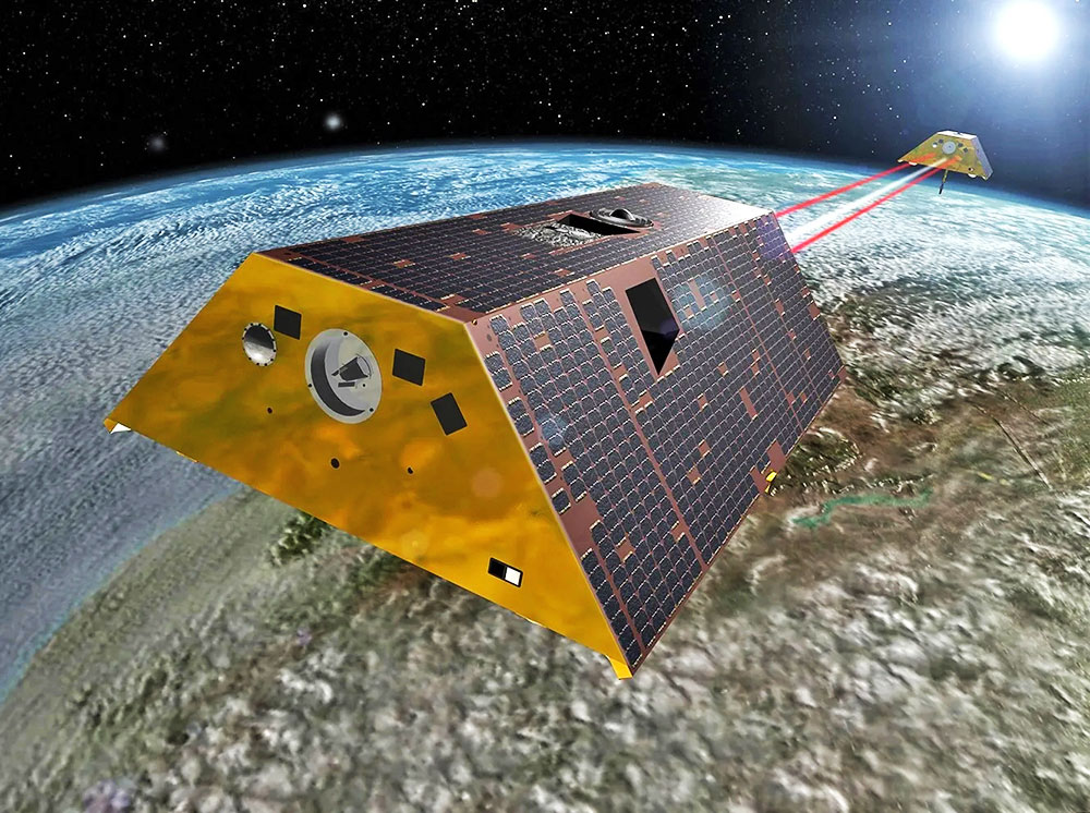
The
GRACE (Gravity Recovery and
Climate Experiment) mission was a pioneering collaboration between,
Launched in March 2002,
the mission's pair of identical satellites operated until October
2017.
Their primary objective
was to detect variations in Earth's gravity resulting from mass
movement on and beneath the planet's surface.
By producing monthly maps of these gravity anomalies, GRACE provided
invaluable insights into several key Earth processes.
The data enabled
scientists to track changes in ice sheets and glaciers,
particularly in regions like Greenland and Antarctica...
Additionally, the mission
highlighted shifts in underground water storage and offered critical
observations on sea levels, ocean currents, and even the dynamics
deep within Earth's mantle.
Building on the success of GRACE, the GRACE-FO (GRACE
Follow-On) mission was launched in May 2018.
Its main goal is to
ensure continuity in the collection of gravity anomaly data
initiated by its predecessor.
As of September 2023,
GRACE-FO remains operational, perpetuating its vital role in Earth
observation.
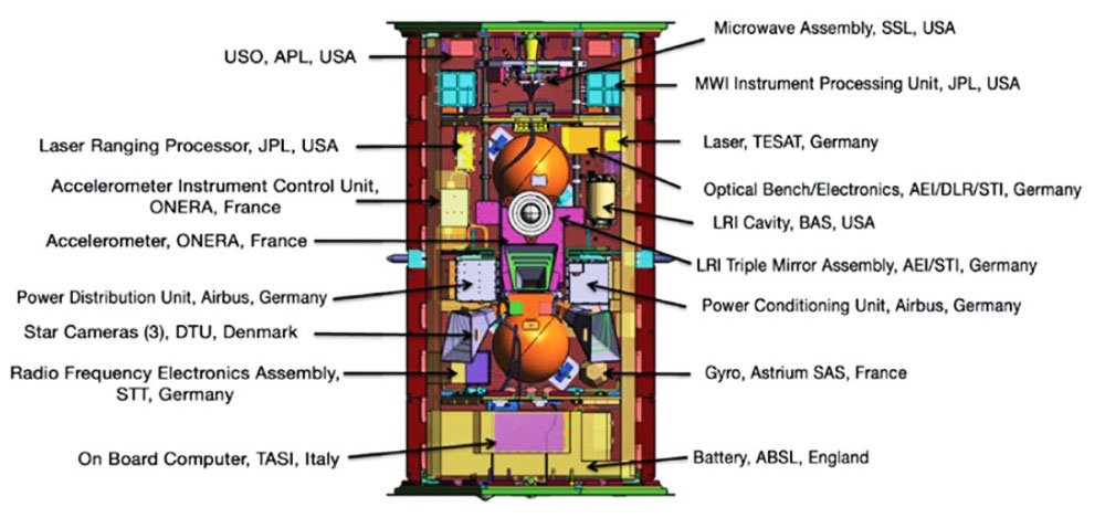
While GRACE-FO mirrors
the core objectives of the original GRACE mission, it boasts
advancements in technology.
One notable
enhancement is the inclusion of a laser-ranging interferometer,
anticipated to refine the precision of measurements between the
two satellites.
Through this follow-on
mission, scientists continue to deepen their understanding of
various Earth processes, spanning climate science, hydrology,
oceanography, and geophysics.

Source
Measuring ice
mass from space…
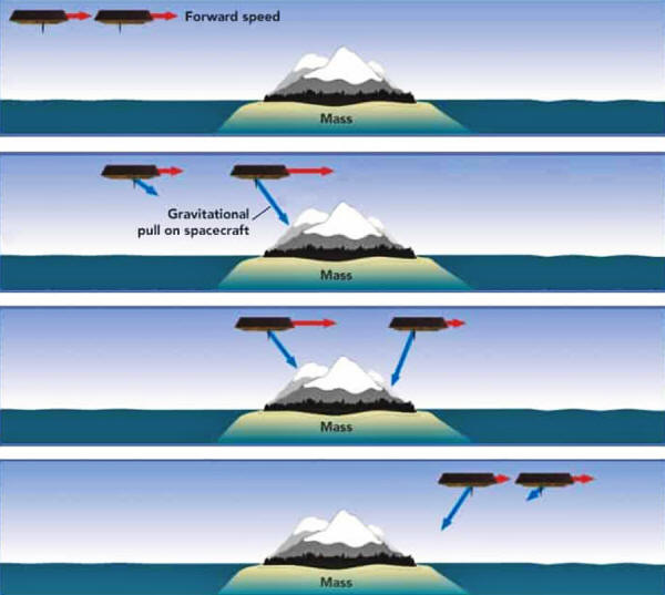
The GRACE and GRACE-FO missions utilize a unique
approach to monitor changes in ice mass, especially in regions like
Antarctica.
Unlike traditional observation methods,
these missions don't
directly measure the ice itself.
Instead, they focus
on detecting gravity anomalies, which serve as indicators of
mass changes.
Both missions employ,
a pair of satellites
flying in tandem in a polar orbit...
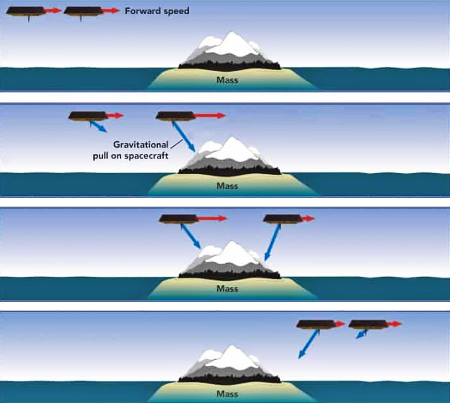
The primary principle
behind their operation hinges on gravitational pull.
As the leading satellite approaches an area with a significant mass
- be it a mountain range or a dense portion of an ice sheet - it
experiences a stronger gravitational attraction.
This causes the satellite to momentarily accelerate, creating a
slight increase in the distance between itself and its trailing
counterpart. As the second satellite subsequently approaches the
same mass, it experiences a similar acceleration.
This delicate dance, with satellites constantly adjusting their
relative distances due to Earth's gravity, allows for precise
mapping of gravitational variations.
In GRACE-FO, this
precision is further enhanced by a laser-ranging interferometer.
The magic lies in the interpretation of this data.
Ice, being a
substantial mass, exerts its own gravitational pull.
When regions like
Antarctica lose ice, whether through melting or calving events,
there's a discernible decrease in gravitational pull in that
vicinity.
Conversely,
significant snowfall
or ice accumulation results in an increased gravitational
attraction.
By processing the raw
satellite data into monthly gravitational maps and analyzing these
over time, researchers can identify regions undergoing gravitational
increase or decrease.
The real-world implications of these findings are profound.
By pinpointing areas
where gravity has changed over consecutive months or years,
scientists can deduce the loss or gain of ice mass in
Antarctica.
This not only paints a
clearer picture of the state of ice on the continent but also aids
in predicting potential future sea-level rise.
Source
GRACE and
GRACE_FO data…
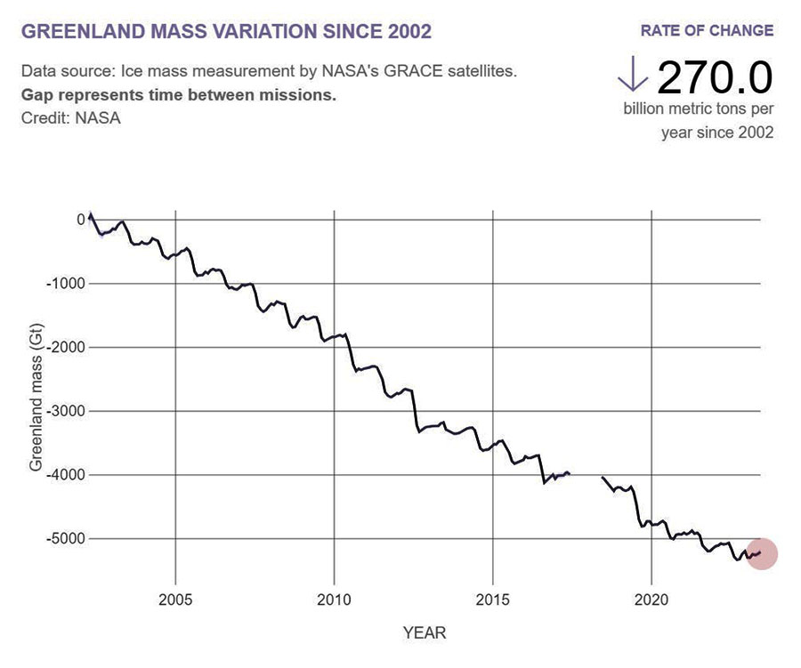
In Greenland, the GRACE missions detected pronounced ice mass loss.
Since 2002
Greenland's ice sheet diminished by approximately 270 gigatons
annually.
This significant decrease
in ice mass underscores the rapid changes that have occurred in the
Arctic, however, a significant slowdown in melting since 2020 is
evident.
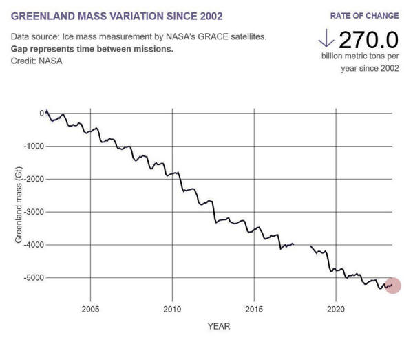
Source
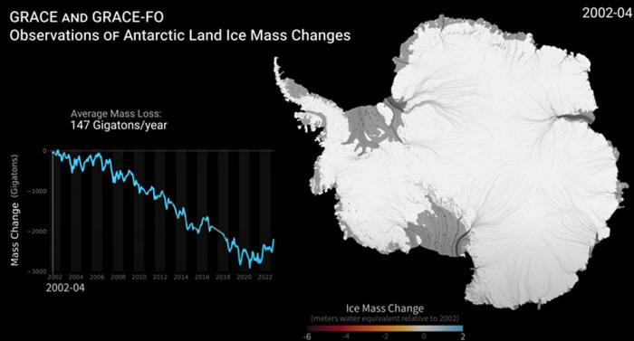
Antarctica presented a more complex picture.
While the continent
as a whole lost about 130 gigatons of ice each year during a
similar timeframe, the loss was most pronounced in West
Antarctica, especially around the Amundsen Sea sector.
This accelerated melting
in West Antarctica is a matter of particular concern for
researchers, as it is claimed to have the potential to destabilize
larger sections of the Antarctic ice sheet, leading to more
pronounced sea-level rise in the future.
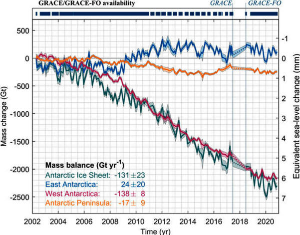
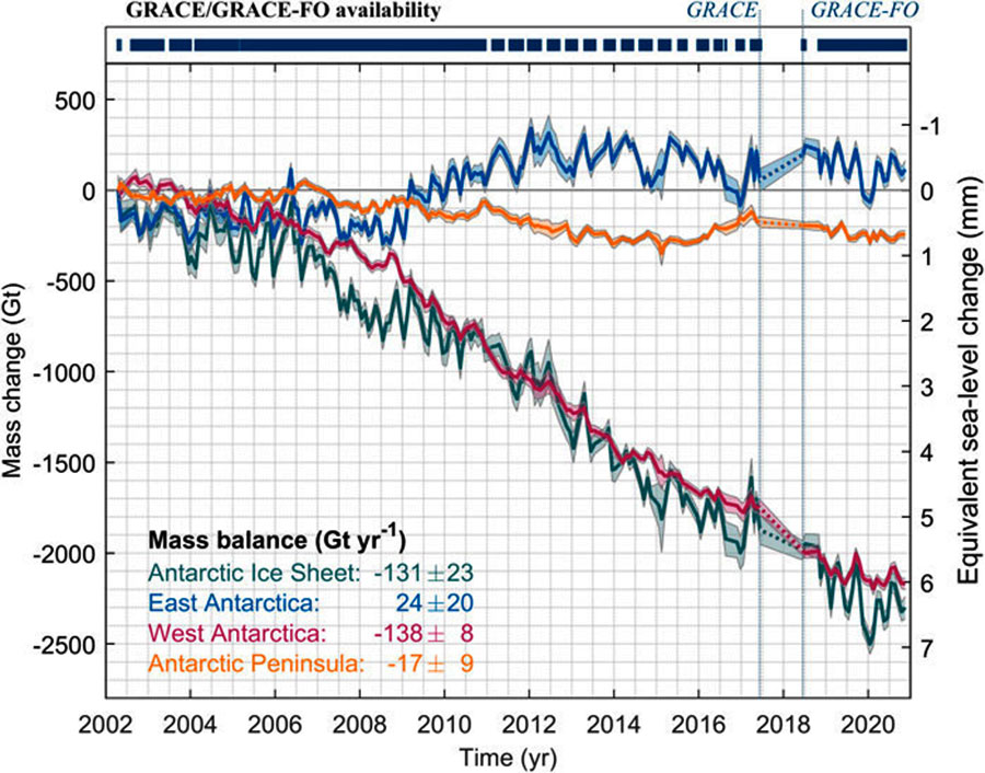
Mass change of the Antarctic Ice Sheet
from
April 2002 to September 2020.
Time
series of mass change from
the
GRACE and GRACE-FO missions, M(t),
for the
entire Antarctic Ice Sheet (green) and its division into
East
Antarctica (blue), West Antarctica (red),
and the
Antarctic Peninsula (orange).
The
vertical lines indicate the end of the GRACE
and the
beginning of the GRACE-FO monthly data availability
(June
2017 and July 2018, respectively).
Shadings represent 1-σuncertainties.
Equivalent sea-level contribution (right axis)
is
approximated as 1 mm sea-level rise
for
360 Gt of ice mass loss.
Source
However, since early 2020, nearly 1,000 gigatons of ice have been
added to Antarctica.
This remarkable ice
gain represents nearly one-third of the total ice loss since
2002...
Source
What's causing
the melting of West Antarctica?
While it's true that CO2 and other greenhouse
gases can contribute to an overall 'increase'
in global temperatures, the effects of this warming
can manifest differently across regions due to various local and
regional factors.
A study published in the journal Nature in 2020, titled "Low
Antarctic continental climate sensitivity due to high ice sheet
orography" concludes:
The Antarctic
continent has not warmed in the last seven decades, despite a
monotonic increase in the atmospheric concentration of
greenhouse gases.
When looking at
Antarctica, the continent is vast, diverse, and influenced by a
combination of atmospheric, oceanic, and geophysical conditions that
contribute to changes in ice dynamics.
One of the biggest drivers of ice melt in West Antarctica is warm
ocean water getting underneath the floating ice shelves.
The Circumpolar Deep Water (CDW) is a relatively warm and
salty water mass.
It's more pronounced
in West Antarctica, especially in the Amundsen Sea sector, where
it can get beneath ice shelves and melt them from below.
Changes in atmospheric
circulation can affect different parts of the continent differently.
For example, the
Antarctic Peninsula, which juts out toward South America, has
experienced more warming in recent decades, partly because of its
unique position and the atmospheric patterns it encounters.
East Antarctica, which is largely comprised of the East Antarctic
Ice Sheet, is primarily situated on a continental landmass that's
higher in elevation.
In contrast, much of
the West Antarctic Ice Sheet rests on bedrock that's below sea
level.
This makes West Antarctica particularly vulnerable to oceanic
intrusion and the associated melt.
Finally, West Antarctica
is home to a significant number of subglacial volcanoes, primarily
concentrated within the West Antarctic Rift System.
This region stands out as
one of Earth's most geothermally active areas. These subglacial
volcanoes have the potential to heat the base of the ice sheet,
causing what is known as basal melting.
This process can form
subglacial lakes and potentially lubricate the glaciers' bases,
which might influence their speed as they flow toward the sea.

Source
In conclusion,
the complexity of
melting in Antarctica, and the recent mass gains reported
by GRACE-FO, suggest that atmospheric CO2 plays
a minor role in large-scale ice dynamics and future
sea-level rise...
Video
|