|

by Mitch Battros
September 20, 2011
from
WinterHawkMultiply
Website
More evidence of the 'global warming
cabal' changing scientific facts and a distinct plan to condition
the population into believing the 1988 made-up name of 'global
warming' is melting the Earth "permanently."
The global warming zealots have
actually,
"changed the World Atlas which has
erased 15% of Greenland's permanent ice cover."
This is nothing less than a "LIE."
The discrepancy was first brought to the SPRI's attention via a
media release accompanying the publication of the 13th edition of
The Times Comprehensive Atlas of the World stating that the Atlas is
"turning Greenland 'green'."
Scientists from the Scott Polar Research
Institute (SPRI) were extremely puzzled by this statement and the
claim that,
'For the first time, the new edition
of The Times Comprehensive Atlas of the World has had to erase
15% of Greenland's once permanent ice cover - turning an area
the size of the United Kingdom and Ireland 'green' and
ice-free'.
The Three People Who
Made-Up Global Warming

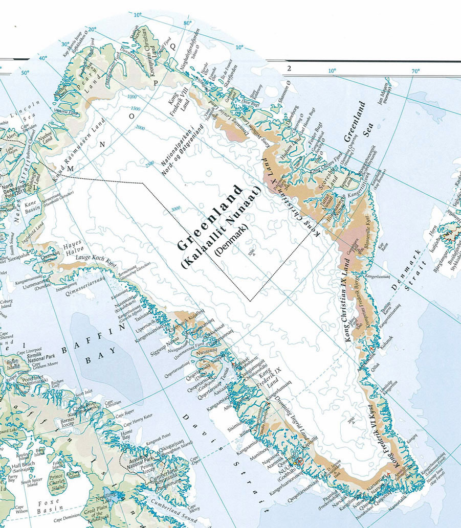
SPRI scientists compared recent
satellite images of Greenland with the new map and found that there
are in fact still numerous glaciers and permanent ice cover where
the new Times Atlas shows ice-free conditions and the emergence of
new lands.
Furthermore, the low-lying fringe of the
main ice sheet appears to be shown as land - not ice. They concluded
that a sizable portion of the area mapped as ice-free in the Atlas
is clearly still ice-covered.
Time Waits for No One It Seems
-
"The Times" Comprehensive Atlas of The World
13th Edition -
by
JustMEinT Musings
September 21, 2011
from Justmeint Website
A new edition of the world’s most prestigious and authoritative
reference atlas.
Its beautifully illustrated section on contemporary
themes from climate to economy and fully up-to-date reference maps
blends authority, tradition and style to set this atlas apart as the
benchmark of cartographic excellence. source
What the publishers neglect to mention is that in their ‘wisdom’ (sic) they
have redrawn maps to suit the AGW agenda!
Mitch Battros tells us
today:
-
More evidence of the ‘global
warming cabal’ changing scientific facts and a distinct plan
to condition the population into believing the 1988 made-up
name of ‘global warming’ is melting the Earth “permanently.”
The global warming zealots have actually “changed the World
Atlas which has erased 15% of Greenland’s permanent ice
cover.” This is nothing less than a “LIE.”
-
The discrepancy was first
brought to their attention via a media release accompanying
the publication of the 13th edition of The Times
Comprehensive Atlas of the World stating that the Atlas is
‘turning Greenland ‘green’.
Scientists from the Scott Polar
Research Institute were extremely puzzled by this statement
and the claim that,
-
The scientists believe that the
figure of a 15% decrease in permanent ice cover since the
publication of the previous atlas 12 years is both incorrect
and misleading.
-
SPRI scientists compared recent
satellite images of Greenland with the new map and found
that there are in fact still numerous glaciers and permanent
ice cover where the new Times Atlas shows ice-free
conditions and the emergence of new lands.
Furthermore, the
low-lying fringe of the main ice sheet appears to be shown
as land, not ice. They concluded that a sizable portion of
the area mapped as ice-free in the Atlas is clearly still
ice-covered.
-
Dr Poul Christoffersen said:
-
The scientists do not disagree
with the statement that climate is changing and that the
Greenland Ice Sheet is affected by this. They say, however,
it is crucial to report climate change and its impact
accurately and to back-up bold statements with concrete and
correct evidence.
-
A close inspection of the new
map of Greenland shows that elevation contours are
noticeably different to the contours in an older map. Dr.
Ian Willis and Toby Benham from SPRI were able to reproduce
these contours using ice thickness data. It appears that the
Times Comprehensive Atlas of the World may have used 500m
ice thickness to map the ice sheet margin. If so, it is
obviously an incorrect and flawed procedure.
-
The discrepancy between the new
map of Greenland and very recent satellite images detected
by SPRI are shown on the BBC website.
-
The Scott Polar Research
Institute points out that the volume of ice contained in the
Greenland Ice Sheet is approximately 2.9 million cubic
kilometers and the current rate at which ice is lost is
roughly 200 cubic kilometers per year.
This is on the order
of 0.1% by volume over 12 years. Numerous glaciers have
retreated over the last decade, capturing the attention of
scientists, policymakers and the general public.
Because of
this retreat, many glaciers are now flowing faster and
terrain previously ice-covered is emerging along the coast -
but not at the rate suggested in the media release
accompanying the new edition of new The Times Atlas.
-
The SPRI scientists raising the
alarm include:
This in not just sad this is BAD, very
very bad indeed.
Yesterday I pondered over today's youth
being fed misinformation and downright lies by politicians. Now we
have yet another blatant political ploy, designed to mislead people
seeking information from what once could have been called the
“benchmark of cartographic excellence”.
Now it is nothing more than
a collection of politically motivate disinformation, being sold to
the general public at a very high price indeed! RRP One Hundred and
Fifty British Pounds per copy.
It is now nothing more than another disreputable
Anthropogenic
Warming collection of propaganda, echoing,
Times Atlas is owned and published by
News International, (Rupert
Murdoch). It became part of HarperCollins Publishers in 1989, along
with Collins Publishers (UK) and Harper & Row (US).
People I suggest we boycott News International, they have shown
exactly where their bias lies…….
The UK Telegraph
says:
The Times Atlas is not owned by The
Times newspaper. It is published by Times Books, an imprint of
HarperCollins, which is in turn owned by Rupert Murdoch’s News
Corporation.
A spokesman for HarperCollins said its new map was based on
information provided by the US National Snow and Ice Data Center
(NSIDC).
The spokesman said:
“Since The Times Comprehensive Atlas of the
World 10th Edition, in 1999, we have had to erase 15 per cent of
Greenland’s once permanent ice sheet.
“This is based on information provided by the much respected and
widely-cited National Snow and Ice Data Center (Atlas of the
Cryosphere, Boulder, Colorado USA).
It seems a mistake was made. I caught
this over at
ACM…
But HarperCollins put out a
statement on Tuesday saying:
“For the launch of the latest
edition of the atlas we issued a press release which
unfortunately has been misleading with regard to the
Greenland statistics. We came to these statistics by
comparing the extent of the ice cap between the 10th and
13th editions of the atlas.
The conclusion that was drawn
from this, that 15% of Greenland’s once permanent ice cover
has had to be erased, was highlighted in the press release
not in the atlas itself. This was done without consulting
the scientific community and was incorrect. We apologize for
this and will seek the advice of scientists on any future
public statements.”
(source)
Times Atlas Publishers Apologize for...
'Incorrect' Greenland Ice Statement
by Fiona Harvey
20 September 2011
from
Guardian Website
|
HarperCollins says
it stands by the accuracy of the maps, but the media
release suggesting 15% of Greenland's permanent ice
cover had melted was incorrect |
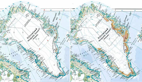
The Times
Comprehensive Atlas of the World
shows Greenland as
having 'lost' around 15% of its ice cover
between the 1999 10th
edition (left) and 2011 13th edition (right).
Scientists argue the
depiction is wrong.
Photograph: Times
Comprehensive Atlas of the World
The publishers of the Times Atlas were
forced to admit on Tuesday that they were wrong to claim the
Greenland ice pack had shrunk by 15%, as Arctic scientists rounded
on the company for misinterpreting data and failing to consult them.
The humiliating climb-down for HarperCollins - part of
Rupert Murdoch's publishing empire - came after key sources of
data on the Greenland ice denied that their research, cited by the
Times Atlas, warranted the claims.
Despite criticism of the claim by
scientists, a spokeswoman for the atlas had, as recently as Monday,
issued a robust defence of the claim, saying:
"We are the best there is... Our
data shows that it has reduced by 15%. That's categorical."
But HarperCollins
put out a statement on
Tuesday saying:
"For the launch of the latest
edition of the atlas we issued a press release which
unfortunately has been misleading with regard to the Greenland
statistics. We came to these statistics by comparing the extent
of the ice cap between the 10th and 13th
editions of the atlas.
The conclusion that was drawn from
this, that 15% of Greenland's once permanent ice cover has had
to be erased, was highlighted in the press release not in the
atlas itself. This was done without consulting the scientific
community and was incorrect.
We apologize for this and will seek
the advice of scientists on any future public statements."
Experts at the US's main research body
for the Arctic, the National Snow and Ice Data Centre (NSIDC), said their
estimates showed that the Times Atlas was wrong.
In a statement, NSIDC said:
"[We have] never released a specific
number for Greenland ice loss over the past decade... The loss of
ice from Greenland is far less than the Times Atlas brochure
indicates."
They joined experts from the UK's Scott
Polar Research Institute (SPRI) in Cambridge, who criticized the Times Atlas for
failing to consult researchers before publishing the claims.
However, the publishers' statement was not enough to settle the
controversy, as the company puzzled scientists by continuing to
insist the maps were correct, even though they show as clear of ice
some areas of land around the edges of Greenland that glaciologists
say retain ice cover.
HarperCollins said:
"We stand by the accuracy of the
maps in this and all other editions of The Times Atlas."
Scientists said that the maps showed
some coastal areas of Greenland to be clear of ice, when they were
in fact still ice covered.
A new edition of the Times Atlas - one of the biggest selling
reference books, billed as being "the most authoritative" - is
published every few years, but the changes tend to be relatively
small.
For this, the 13th edition, the publishers raised
a fanfare of publicity, centered on the claim that their surveys of
the Greenland ice cap showed it had diminished in extent by about
15% since 1999, when the 10th edition of the atlas was
published.
But claims about ice can be slippery - although Greenland has been
losing ice mass, and the area covered by ice is gauged to be smaller
than in past decades, to put a precise figure on the loss is
difficult, as ice cover can change from year to year and seasonally,
and depends on the volume of ice as well as its extent.
Although the
amount of ice lost is likely to be about 200 cubic kilometers per
year, this is still tiny compared with the enormous extent of the
ice, at about 2.9m cubic kilometers in total, according to data from
the
Scott Polar Research Institute.
Although ice loss is
accelerating, it could still take centuries for the Greenland ice
cap to melt away - if a 15% loss in 10 years were true, it would
mean that all of the key climate change models would have to be
drastically redrawn.
Scientists are confident that the observed loss of Arctic ice -
which can be graphically illustrated in the retreat of some of the
island's biggest glaciers and the break-up of thinning sea ice, for
instance - is a result of the observed warming temperatures of the
past decades.
However, glaciologists are wary of making sweeping claims about ice
loss. Such a claim landed the Intergovernmental Panel on Climate
Change (IPCC) in hot water nearly two years ago, when a prediction in its
2007 report on climate science suggested that the Himalayan glaciers
could have largely disappeared by 2035.
This was subsequently
found
to be incorrect, and severely damaged
the IPCC's 'reputation.'
Poul Christoffersen, glaciologist at the Scott Polar Research
Institute, said he and fellow researchers had examined the atlas and
found that,
"a sizeable portion of the area mapped as ice-free in the
Atlas is clearly still ice-covered".
He added that there was,
"to our
knowledge no support for [the 15% ice reduction] claim in the
published scientific literature."
Christoffersen said:
"A close inspection of the new map of Greenland
shows that elevation contours are noticeably different to the
contours in an older map. My colleague Toby Benham, a scientist at
the Scott Polar Research Institute, was able to reproduce these
contours using ice thickness data.
It appears that the Times
Comprehensive Atlas of the World may have used 500m ice thickness to
map the ice sheet margin. If so, it is obviously an incorrect and
flawed procedure."
He said the previous Times Atlas maps appeared to show a truer
picture of the ice extent.
"I would by far rather use the old maps
for education and for students."
He added that HarperCollins was cooperating in sharing the data and
methods used for the maps.
Although a loss of 0.1 per cent of Greenland ice in total over more
than a decade might seem a small proportion, he said it was still
enough to cause a problematic rise in sea levels in future years,
because of the huge scale of the Greenland ice sheet.
"A small
percentage of a very big number is still a big number," he said.
Prof J.Graham Cogley, professor of geography at Trent University in
Canada, said:
"What may have happened is that somebody has examined
a satellite image and mistaken the snowline for the ice margin.
Snow
is much brighter than bare ground, but it is also a good deal
brighter than bare ice, of which there is quite a lot in summer
around the margin of the Greenland ice sheet."
|