|
Chapter 2
The Polar Pivotal Axis
There is no doubt that the Planet Earth’s Polar Axis has shifted
during its geological history. Evidence of such shifting can be
found all over the world. Any academic difference of opinion resides
in the question of exactly when these Polar Axis Shifts occurred. On
the one hand, there are traditional scientists and geologists who
date these shifts millions of years into the past, stating that
there is absolutely no evidence that such shifts occurred within
recent geologic times. But on the other hand, there is the Velikovskian School which dictates that
at least one of these Polar
Axis Shifts, perhaps even two or three of them, occurred within
recorded historic times.
This academic disagreement was partly
reflected in what has become known as “The Velikovsky Affair”, in
which mainly Ivy League professors such as the late astronomer
Carl Sagan of Cornell University and the controversial paleontologist
Stephen Jay Gould of Harvard University disputed the science of the
theories of the late Dr. Immanuel Velikovsky of Princeton
University. As a longtime Velikovskian, I belong to the
Velikovskian
School and agree that a Polar Axis Shift did indeed occur in
historic times, namely in the 16th Century BCE, as Dr. Velikovsky
theorized in Worlds In Collision; and to wit, exactly in the year
1587 BCE. The North Pole shifted from a position in the
North
Atlantic Ocean to its current Arctic location, and the
South Pole
shifted from off the southern coast of Australia to the current
Antarctica.
Regardless of which side of the timeframe fence one sits on, there
is a single point of agreement amongst everyone, a common
perplexity: what were the precise causes of these past Polar Axis
Shifts? Most scholars admit that they could not have occurred
without the intervention of a powerful external body capable of
“torqueing” the Earth from one axis to another; the Earth could not
shift on its own, from internally. Speculation has ranged from a
giant comet passing too close-by, or an asteroid hitting the Earth,
or some unknown “cosmic body” passing in our vicinity, all on a
purely unpredictable and random basis. To date, however, no one has
devised a completely satisfactory explanation for this mysterious
phenomenon. Apparently, no one knows the answer as yet.
Here I am proposing that the “cosmic agent” causing these periodic
Polar Axis
Shifts is the nomadic Rogue Planet X Nibiru, which was responsible
for the
previous catastrophe in the 16th Century BCE. So far, no one else,
including
Zecharia Sitchin or even anyone within the Velikovskian School, has
proposed such
an alternative theory. And I also propose that these shifts are
predictable both in
time and location, because these shifts occur once every 3,600 years
along Polar
Belts determined by a Polar Pivotal Axis, which is a line drawn
straight down
through the top of the Great Pyramid of Egypt and coming out in the
Mid-Pacific
Ocean at 30 degrees south latitude and 150 degrees west longitude,
exactly opposite the Pyramid which is at 30 degrees north latitude
and 30 degrees east longitude. The arrival sequence of the Planet X
Nibiru and its attempt to tether itself to Earth’s North Polar Belt
by the use of an electromagnetic beam results in a pivoting, or torqueing effect, causing the
Pyramid-Oceania Polar Pivotal Axis to
tilt to New Polar Zones.
HOWEVER, the Great Pyramid Complex itself
would STILL be located 30 degrees above the NEW Equator and 60
degrees south of the NEW North Pole, as it is today. The same would
be true for the opposite pivotal point in Oceania. ONLY these two
locations would have the same latitudinal position as before, 30
degrees above the Equator and 60 degrees away from their respective
Poles. Every other geographic location on Earth would change, some
by not very much, others greatly by comparison.
And here the proposition is taken for granted that there were no
traditional “Ice
Ages”, that these so-called “Ice Ages” simply reflect the presence
of Polar Ice in
various other Polar Zones around the globe. The ice of the
present-day North and
South Poles did NOT expand southwards and northwards, causing these
strange icesheets
in otherwise unfrozen modern locations. Nevertheless, the locations
of these ice-sheets would be most critical with respect to the
creation of a pattern of shifting. Primarily in Earth In Upheaval,
Dr. Velikovsky described many anomalies of geological evidence from
around the world. A good example would be the existence of extinct
tropical coral reefs underneath the present North Polar Ice,
indicating that at one epoch in time our now-frozen Arctic Ocean had
a tropical climate.
Dr. Velikovsky gives us evidence of ice-sheets
in India, South Africa, Northeastern Brazil, Ghana, North America,
Europe, Mexico, Hawaii and Australia. If one plots these various
locations on a world globe, one immediately notices how they tend to
ring the area of Egypt, at a distance of about 50-60 degrees in all
directions. Furthermore, there is absolutely no evidence of an “Ice
Age” in the modern Middle East itself. It is from that point of view
that I began—in 1973—to make my assumptions regarding the Great
Pyramid of Egypt as having been deliberately built in that
geographic location, amongst other reasons, “to mark the spot” of
the Polar Pivotal Axis. That, of course, is a most radical
supposition, and I am the first to admit it.
If one disassembles a world globe and inscribes upon it a circle
with its center at Cairo and a radius from there to the current
North Pole, that circle would become the North Polar Belt.
Similarly, if one inscribes a circle with its center exactly
opposite Cairo in Oceania and a radius to the South Pole, that
circle would become the South Polar Belt. These two circles would
denote the thickest parts of the icesheets in other locations, with
Polar Ice extending away from those lines in proportion to what it
extends today outwards from the Arctic and Antarctic. All “Ice Ages”
fall within these Polar Belts, and there is no evidence of “Ice
Ages” in other locations. Coincidence? You decide.
Next, if one further inscribes an equatorial line between the
Pyramid-Oceania Polar Pivotal Axis, this line would become a
Pyramid-Oceania Polar Pivotal Equator; and it would divide the globe
into two Polar Hemispheres,
-
a North Polar
Hemisphere with its center
at the Great Pyramid of Egypt
-
and a South Polar Hemisphere with its
center in Oceania, separating these two hemispheres exactly halfway
between the North and South Polar Belts.
All geographic locations
along this Pyramid-Oceania Polar Pivotal Equator would NEVER
experience or have experienced extreme polar glaciation of any sort.
This line passes through the following modern geographic locations:
Here
is what is inscribed on one such sign, erected in 1983 beside
Interstate Highway 90 northwest of Madison, Wisconsin:
“Several times during the ice ages, glaciers flowed out of Canada,
sometimes reaching as far south as the Ohio and Missouri rivers.
During recent glaciations, southwestern Wisconsin was untouched,
because the glaciers were diverted to the east or west by the
highlands of north-central Wisconsin and northwestern Michigan.
Here, in the Driftless Area, you see a rugged landscape with deep
valleys and rocky crags. Much of the Midwest would look like this
today if it had not been glaciated, but the ice sheets smoothed
those areas by eroding away the crags and filling in the valleys.
The Driftless Area was never completely surrounded by ice, and the
glaciers reached only its eastern edge during the last glacial
episode. At that time, about 15,000 years ago, the Wisconsin River
was dammed by the glacier, and the sediment deposited in glacial
Lake Wisconsin forms the flats between Tomah, Wisconsin Dells and
Wisconsin Rapids. Then the Driftless Area was treeless and had a
tundra climate.”
Such areas like Anchorage, which is near the
Arctic
Circle and therefore cold and wintry, is itself never under the
greater part of a Polar Icecap, despite the presence of several
technical glaciers in its general vicinity. St. Petersburg, Russia,
is at the same 60-degree north latitude as Anchorage, and we
certainly do not consider modern St. Petersburg to be “glaciated”.
Anchorage, incidentally, will someday be in a comparable southern
location as it is today, when a future South Pole will be located
just northeast of the Hawaiian Islands, except that Anchorage will
be the same distance from that SOUTH Pole, not North Pole.
Although it would actually be impossible from existing evidence to
predict exactly
where on the Polar Belts each succeeding Polar Alignment would be
located, in that
these shiftings could be either random or systematic, it is the
hypothesis here that
they shift in an orderly fashion in a CLOCKWISE manner when viewed
from the
overhead perspective of the Great Pyramid of Egypt. As Dr. Velikovsky’s
theoretical North Pole shifted from the North Atlantic to the Arctic
in a clockwise
manner, so also might the next shift be in the same clockwise
direction from the
Arctic towards Mongolia and the previous shift have been from the
Mid-Atlantic to the North Atlantic.
After one prepares a world globe to represent all of the various
Polar Zones and Equators, as well as the Pyramid-Oceania Polar
Pivotal Equator, one can spend many hours speculating about this or
that detail. For example, if the North Pole were located in the
Mid-Atlantic Ocean between Luanda, Angola, and Recife, Brazil, and
the South Pole were located just southwest of the Marshall Islands,
then the resulting Equator would pass through Antarctica and travel
across the presently eastern Pacific Ocean to Acapulco, Mexico City,
Laredo, Dallas, Tulsa, Kansas City, Minneapolis, Hudson Bay,
Northern Greenland, Spitzbergen Island and then go across the
Barents Sea into Russia, pass through Perm and the Aral Sea, and
stretch into Afghanistan, Pakistan and Western India before heading
out into the Indian Ocean via Diego Garcia, back to Antarctica. In
such a Polar Alignment, the present-day Arctic Ocean would be
located near the equatorial tropics and would certainly contain
coral reefs of which, as was noted, we have modern evidence.
And
many other similar observations can also be made, when one considers
various areas of the world which have apparently undergone extreme
climatic changes from equatorial to polar (Arctic), which used to be
forests but now are deserts (Saudi Arabia), or which used to be
under the ocean but now are dry land (Texas). My demonstration of
this “polar globe” was not included in the 2003 video, Planet X -
Assessing The Science, which is available for purchase Planet X
Video. At a June 1999 Catastrophism Conference, hosted by Professor Emilio Spedicato at the
University of Bergamo in Italy, a number of
respected authors and researchers presented a series of papers and
lectures. Reprinted below, as they appeared in the September 2000
edition of The Velikovskian Journal (Volume V, Number 1) published
by Charles Ginenthal in New York, are three “abstracts” or overviews
of these papers and lectures, as they pertain to Polar Axial
Displacement.
CHANGES IN THE ROTATION AXIS OF EARTH AFTER ASTEROID OR
COMETARY IMPACTS
By Flavio Barbiero
Centro Camuno di Studi Preistorici
Capodiponte, Italia
Evidence exists that the poles have changed position during the
recent past in a very
rapid way—in a matter of days. This possibility, however, so far has
been
disregarded by official science on the basis that such a phenomenon
is thought to be
physically impossible: no mechanism is known and no energy capable
of provoking
it. The hypothesis that the inclination of the terrestrial axis in
relation to the ecliptic and the position of the poles might change
has however been taken into consideration since last century. Some
of the greatest scientists of the time, including J.C. Maxwell and
Sir George Darwin, considered this problem but decided that the
stabilizing effect of the equatorial bulge was so great that no
conceivable force originating within the Earth could lead to a
shifting of the axis, except for the collision with another planet.
They did not take into account, however, the phenomena of
instability which could occur to an Earth-like gyroscope, consisting
of a plastic shell, easily deformed by centrifugal forces, covered
by freely-moving liquids—the only body of this kind in the solar
system.
Our work shows that the impact of extraterrestrial objects as small
as an Apollo class asteroid could “trigger” a process which in a
matter of days would cause a “reshaping” of the equatorial bulge
around a different axis, inducing therefore a shift of the poles and
a change of the tilt. In order to trigger the process, the peak
value of the torque developed by the impact has to overtake a
“threshold” value, equal to the stabilizing torque developed by the
equatorial bulge. A rough calculation shows that the threshold value
can be reached during the impact with a body much smaller than a
one-kilometer-sized asteroid.
A shift of the poles would cause worldwide destructive phenomena
such as:
-
earthquakes and volcanic activity in all areas interested [sic] by
adjustments of the crust
-
violent winds and torrential rains, with
unprecedented floods all over the world
-
wide fluctuations of the
oceans’ level, with subsequent temporary submersion of large parts
of the continents
-
perturbation of the magnetic field
On top of
that, there would be permanent changes of the climate, due on one
side to the shift of the poles (and therefore to a change of
latitude of many regions, deviation of oceanic and atmospheric
currents and so on); on the other side, to the change of the tilt,
with subsequent modification of the seasonal pattern. A shift of the
poles occurring at the end of the Pleistocene, with all its related
destructive phenomena, could explain coherently the climatic
situation before that date, and the situation observed after that
date, as well as ancient traditions about a worldwide catastrophe.
THE DELUGE IN THE PEOPLES’ TRADITIONS AND GEOLOGICAL
EVIDENCE
By Alexander Tollmann
University of Vienna, Austria
In 1992 the geologists Edith and Alexander Tollmann published a
monograph
which claimed that the Noachian Deluge was the consequence of a
cometary impact
about 9,500 years ago. A series of geological facts supported the
claim, together
with a critical analysis of mankind’s traditions. Geological proofs
of the impact
include a crater with iridium, shatter cones, stress lamination of
minerals, radiocarbon dating, dendrochronology, a peak of acid in
the Greenland and so on. Over a thousand worldwide traditions
describe moreover every detail of the catastrophe following the
impact and the spiritual consequences on the human mind. In our
present communication we will add new proofs of the impact.
They
include analysis of the Koefels crater in Tyrol and new radiocarbon
dating. The hiatus of settlements for this time is recorded from
many places in the world, both from villages and caves. The impact
led to the development of religions, to a confusion of languages, to
the transition from a hunting and collecting economy to an
agricultural and cattle-breeding economy and so on. Another impact,
the “Late-Glacial Impact”, occurred as a forerunner about 3,500
years before the Noachian Flood. We have been led to its existence
by several indications: torrential rainfalls, fallout of nitric
acid, the extinction of most of the Pleistocene mega-mammals…The
Late-Glacial Impact is also supported by the discovery of its
conflagration (Weltenbrand) horizon, which has been documented by
J.B. Kloosterman in more than a dozen countries on three continents.
The epoch of this impact is the Allerod time, about 13,000 BP [that
is, BCE], still in the younger Paleolithic (Termination IA), whereas
the Noachian Flood Impact occurred in the Mesolithic (Termination IB),
about 9,500 years BP. The Late-Glacial Impact was caused by a comet:
its fragments struck the northern hemisphere, in particular the ice
of the Canadian Ice Shield, leading to the giant “Debacle” flood
(Ontario, 450 km. wide) and the Spokane Flood, in the Columbia
Basin.
DENDROCHRONOLOGICAL DATING, RESULTS AND OPEN
PROBLEMS
By Mark Baillie
Queen’s University, Belfast, United Kingdom
The availability of long, year-by-year, tree-ring chronologies from
a spread of
locations has allowed the exploration of several abrupt, apparently
catastrophic,
environmental events in recent millennia. This paper will explore
the ways in
which data are accumulating relevant to these events. It will also
explore the
chronological pitfalls encountered when evidence from sources of
differing dating
quality are encountered. In many cases there are definite limits to
the precision with
which environmental parameters can be dated. This applies
particularly to
palynological and sedimentary records; even varve records and
ice-cores have their
limitations when it comes to highly refined dating questions.
Currently it is fair to
say that, for anything earlier than the present millennium, there is
no good
understanding of the causes of the various environmental downturns
noted in the
tree-ring records. The paper will also explore some of the
possibilities which have
been tentatively addressed so far, namely volcanism,
extraterrestrial bombardment and undersea outgassing.
In 1984 Val LeMarche and Kathy Hirschboeck pointed out a severe
frost ring in the Californian bristlecone pine tree-ring record
relating to the calendar year 1627 BC. Their suggestion that this
frost event might have been due to the eruption of the Santorini
volcano in the Aegean is still a source of active debate. Their work
stimulated the observation of a series of narrowest-ring events in
an Irish oak chronology at dates 3195 BC, 2345 BC, 1159 BC, 207 BC
and AD 540. These dates, it turns out, fall in the vicinity of
several possibly traumatic environmental events marked in human
records by such phenomena as dynastic changes, Dark Ages and plagues
(Baillie, 1995). Circumstantial cases can be erected which would
allow the environmental downturns to explain some of the human
effects.
Curiously, mythology hints that several of the events may
have had cometary associations. Such cases then allow the
formulation of research programs aimed at uncovering physical
evidence from suitable deposits. Detailed examination of oak
specimens in which the narrowest-ring events were observed, and
consideration of the detailed responses of trees in various
geographical areas to the events, hint at complex reactions over
periods of years; and it may be some considerable time before
definitive solutions are available. In the meantime, active
speculation in the literature is aimed at flushing out relevant
information from specialists in a wide variety of fields.
Note that in these “abstracts” the authors ASSUME that some sort of
“cometary impacts” were necessary to trigger these axis shifts. It
is highly significant that existing records of the Planet X Nibiru,
as Zecharia Sitchin has described in The Earth Chronicles, suggest
that it is “cometary” in appearance because of its “tail” which is
in fact nothing more than the electromagnetic tethering beam that it
unleashes in order to attach its South Pole to our North Polar Belt.
And, of course, the “Venus” of Dr. Velikovsky was “cometary” in
nature. These “abstracts” demonstrate further the difficulty that
one encounters in determining a cause for Polar Axial Displacement
outside the framework of the periodical returns/arrivals of the
Planet X Nibiru, not to mention the futility of calculating exactly
when each repetition recurs if they are considered as “random”
rather than predictable events within this Solar System.
Transcribed below is an article from The Dallas Morning News. It
contains a
perfect example of the fallacy of trying to explain historical
climate changes by
traditional methods. The academic scientific establishment is so
blind to and afraid
of the possibility of catastrophic planetary changes in “recent
times” that their entire
system of dating these events is flawed from the outset. As Dr. Carl Sagan might
have remarked sarcastically to Dr. Immanuel Velikovsky during the
course of The
Velikovsky Affair,
“There is no evidence of such catastrophes in
recent geologic
time; they occurred MILLIONS and MILLIONS of years ago!”
Everybody
is free to choose the “school” in which he or she may wish to
believe. I chose “Catastrophism & Ancient History” years ago,
The Velikovskian School. This recent evidence below can be explained
quite logically if one is aware of the theoretical possibility of a
Polar Pivotal Axis reaching from Cairo to Oceania, generating Polar
Pivotal Belts where North and South Polar Zones are periodically
located, as a result of the recurrent transits of the “custodial”
Planet X Nibiru, the cyclical “Cosmic Tree”.
If, as both Dr. Velikovsky and I have suggested, the last North Pole
was located in the North Atlantic Ocean, then polar ice, other glaciation and permafrost would have extended into northeastern
North America, western Europe and Morocco. During such a scenario,
Haiti, Cuba and Florida would have been located about the same
distance from that North Pole as Anchorage and St. Petersburg are
located away from the present North Pole.
The Gulf of Mexico would naturally have been much cooler, since it
would have been equivalent geographically to, say, that stretch of
the current cold Pacific Ocean from Anchorage to Seattle. Yucatán,
Mexico, would have been situated about the same distance from that
North Pole as Oregon is from the current pole. Moreover, if the
South Pole were located about 1,000 miles (1,600 kilometers) off the
Pacific coast of Mexico, southwest of modern Acapulco, then the
northeastern half of the Gulf of Mexico would have been located just
north of that South Polar Zone, Miami and Havana again at about the
same latitude away, but in the south, as Anchorage is today in the
north; and the southwestern Gulf, southwestern Texas, all of Mexico
and Central America, the Galapagos Islands, and west-coastal
Colombia and Ecuador would have been within that South Polar Zone
(permanent ice to permafrost). Since West Texas was at one time
under the ocean, it is logical to assume that when the South Pole is
located off Acapulco and/or when the North Pole is located in the
North Atlantic Ocean, then Texas is underwater. That’s my guess, at
least, for what it’s worth.
Thus, this “new evidence” is perfectly explainable by The Velikovskian School. When a new theory is inherently true, all of
the peripheral facts, like this one, that come along the pipeline,
will automatically fall into place like clockwork.
Except for the
standard but flawed establishment dating here, which Sagan would
have supported, this is a classic example.
QUOTE
The Dallas Morning News,
By Alexandra Witze,
Science Writer
23 October 2000
Cold winters may have spelled the end for marine critters living in
the Gulf of Mexico 34 million years ago.
More than 90 percent of Gulf mollusks perished at that time. So did
many species that lived on land. Scientists now have some of the
first evidence that climate change snuffed out these animals.
In last week’s issue of Nature, researchers from the University of
Michigan and Syracuse University describe their work on “ear stones”
from fossilized fish. These natural structures accumulate layers of
calcium carbonate each year the fish lives. Scientists can deduce
the water temperature—down to seasonal changes—by analyzing the
ratios of chemical elements in the ear stones. Winter temperatures
in the Gulf dropped 7 degrees Fahrenheit 33.7 million years ago—even
though summer temperatures remained roughly the same, the
researchers reported. The drop is consistent with other evidence
that Earth’s climate shifted at this time from a greenhouse into an
icehouse. Such a cold spell could have caused the major extinction,
they added.
UNQUOTE
As is mentioned elsewhere, the Flood of Noah coincided with the
arrival of the Planet Nibiru in the year 5187 BCE, or approximately
7,200 years ago. Thus below, these “remnants of human habitation”
found under the Black Sea would correlate with that “cosmic
catastrophe”, when the North Pole shifted from the Mid-South
Atlantic Ocean to the North Atlantic and the Planet X Nibiru
“docked” at “Hyperborea” until its departure in the year 4287 BCE.
QUOTE
Associated Press,
13 September 2000
WASHINGTON—Artifacts found at the
bottom of the Black Sea provide
new evidence that humans faced a great flood, perhaps that of the
biblical Noah, thousands of years ago, the discoverers say.
Remnants of human habitation were found in more than 300 feet of
water about 12 miles off the coast of Turkey, undersea explorer
Robert Ballard said Tuesday. “There’s no doubt about it, it’s an
exciting discovery,” Mr. Ballard said from his research ship. “We
realize the broad significance the discovery has, and we’re going to
do our best to learn more.”
Fredrik Hiebert of the University of Pennsylvania, chief
archaeologist for the Black Sea project, said, “This find represents
the first concrete evidence for the occupation of the Black Sea
coast prior to its flooding.”
Many ancient Middle Eastern cultures have legends of a great flood,
including the Bible story of Noah.
Columbia University researchers
William Ryan and Walter Pittman
speculated in their 1997 book “Noah’s Flood” that when the European
glaciers melted about 7,000 years ago, the Mediterranean Sea
overflowed into what was then a smaller freshwater lake to create
the Black Sea.
Last year Mr. Ballard found indications of an ancient coastline
miles out from the current Black Sea coast. His discovery provides
evidence that people once lived in that now inundated region.
Mr. Ballard, a National Geographic Society explorer in residence,
said he had studied shells found along the ancient coastline and
found two types. One group is an extinct type of freshwater shell,
and the second is from saltwater shellfish. The saltwater shells
date back 6,500 years, while the freshwater shells all date to 7,000
years ago and more.
“So we know that there was a sudden and dramatic change from a
freshwater lake to a saltwater sea 7,000 years ago. And we know that
as a result of that flood a vast amount of land went underwater. And
we now know that that land was inhabited. What we don’t know is who
these people are, we don’t know how broad their settlements were…but
we’re expanding our studies to try to determine that,” he said.
Mr. Ballard said his team, using remote-controlled underwater
vessels with cameras, found a former river valley beneath the sea.
In that valley was a collapsed structure, including some preserved
wooden beams that had been worked by hand. The structure was
“clearly built by humans” and was characteristic of stone-age
structures built 7,000 years ago in the interior of Turkey, Mr.
Ballard said. It contained a stone chisel and two other stone tools
with holes drilled through them, he said.
The group is now mapping the site and looking for other structures.
“This is a work in progress,” Mr. Ballard said. “It is critical to
know the exact era of the people who lived there, and to that end we
hope to recover artifacts and wood for carbon dating so we can
figure out what sort of people lived there and the nature of their
tools.”
The discovery occurred within Turkey’s coastal waters. Turkey has a
representative on the research vessel.
Mr. Ballard, best known for finding the remains of the ships
Titanic, Bismarck and Yorktown, among other discoveries, operates
the Institute for Exploration in Mystic, Connecticut.
UNQUOTE
And here is a third recent news article about a discovery off the
coast of northern England. Undoubtedly this submerged land used to
be above sea-level during a previous Polar Axial Alignment. This
article was found on the Web and posted to the Fortean Times
Internet Mailing List. The dates provided below are close enough in
“estimated time” to indicate that this catastrophe was probably
contemporaneous with the Black Sea evidence cited above.
QUOTE
http://www.ananova.com/news/story/sm_86824.html
Scientists say
Britain has its own version of Atlantis under the North Sea. Ancient
stone age communities were wiped out by a series of floods which
scientists say should act as a warning about the dangers of global
warming and rising sea levels.
Dr Ben Horton of Durham University’s Sea Level Research Unit said:
“As our climate and oceans respond to global warming, there will be
potential for global sea level rise on a massive scale.”
He added: “Our investigations have revealed for the first time that
large areas of land can be flooded very quickly.”
After the last ice age, melting ice caused the southern half of the
North Sea to rise by about 65 ft over 2,000 years, leaving an area
the size of Britain underwater. The research team at Durham
University has discovered that Britain also suffered a series of
shorter-term floods which had disastrous effects on the human
population. Between 2,000 and 3,000 people at a time died in the
floods, with hunter-gatherer tribes more likely to live near coastal
and estuarine areas where food was more easily found.
Between 7,600 BC and 5,900 BC, around 1,000 square miles of land in
the North
Sea region would have been flooded by 15 ft high tidal and storm
surges, the
scientists have found. These natural disasters occurred on average
four times each century.
Britain’s land link to the continent was also flooded, leaving the
British Isles lagging thousands of years behind in the rest of
Europe in the development of weapons technology, agriculture and
architecture, the National Geographic reports.
UNQUOTE
The following is a message that came in on the
Fortean Times List on
22 January 2001. In my theory of Polar Axial Displacement, if the
North Pole were located in the central Indian Ocean and the South
Pole were located off the coast of southwestern Mexico, as I propose
that it was from 15,987-12,387 BCE, then the Equator would have gone
right through Wales and southern England. It all falls into place.
But, of course, like Dr. Velikovsky, we have to “shun” these
“geological” dates to make “history” seem “logical”. One simply
cannot straddle the fence on these chronological issues.
QUOTE
http://www.ananova.com/news/story/sm_180721.html
A 300
million-year-old petrified forest has been discovered at an open
cast coal mining site.
Experts say the condition of the fossilised forest, preserved in mud
stone, makes it an extremely rare discovery.
Fragments of more than 40 trees and bushes were uncovered at the
Darrell opencast site in the Dulais Valley, Nant-y-Cefn,
South
Wales. Now experts are working against time to preserve the find,
which last saw daylight when South Wales was sited on the equator
and basked in a tropical climate. They believe the forgotten
tropical forest was laid down at a time when the area was swampland
which gradually silted over.
Cliff Patten, principal planning officer at
Neath and Port Talbot
County Council, say the priority is to ensure the forest is
preserved before it can decompose. “It was discovered about one
month ago and we have been looking at the best way preserve it since
then. This is an extremely rare find,” he said. “One idea is to
encase it in resin so it’s protected from the elements. But at the
moment the fossils are exposed in part of a large open pit.
“The opencast site was given planning permission on the condition
that when all work is finished the land is restored to its former
use. “It is a working mining operation which does make things
difficult. It cannot be left out in the open indefinitely but there
is no danger of immediate decomposition.”
UNQUOTE
QUOTE
Associated Press,
Via The Dallas Morning News,
22 March 2002
ROME
—Near the ruins of
Pompeii, archaeologists have found another,
far-older abandoned settlement, unearthing the remains of buildings,
canals and ornate tools from more than 2,500 years ago.
Italian scientists and the Culture Ministry at a news conference
Thursday announced details of excavations at the ancient riverside
port at Poggiomarino, six miles northeast of Pompeii in southern
Italy.
The site was discovered two years ago during the construction of a
water purification plant.
Like ancient Pompeii—a Roman city destroyed in 79 by an eruption of
Mount Vesuvius—this town was also abandoned because of natural
disaster: a flood in the 6th century B.C.
The 17-acre settlement was founded in about 1500 B.C. on the
River Sarno, and as many as 1,000 people lived there.
Archaeologists described it as a “Bronze Age Venice”. Like that
northeastern, canal-based lagoon city, this too was constructed on
marshy islands—perhaps to prevent invaders from storming their city.
“In that period, all the important ports sprang up along rivers a
little distance from the sea, to avoid pirate attacks,” prehistorian
professor Renato Peroni said at the news conference.
Excavations have yielded traces of horseshoe-shaped stone and wood
foundations, part of a canoe carved from a tree trunk, and ornate
amber broaches and bronze and iron tools.
UNQUOTE
And finally, here is another article that appeared in
The Dallas
Morning News in the Science Section on 5 February 2001. The ultimate interpretation is
completely
wrong, of course, or at least flawed, because it does not take into
account all of the historical data. However, the article does
demonstrate once again that “big events” occurred around 2000 BCE
(Exodus/Santorini) and “8,200 years ago” (add 7,200 years to 1587
BCE and you get 8787 BCE)—not to mention “about 12,000 years ago”,
that old reliable often-cited date for the greatest flood of all,
the one that destroyed the Lost Atlantis, as the Egyptian priests
related to Solon. See
Chapter 5. These climate catastrophes are
caused by the 3,600-year-long orbit of the Planet X Nibiru, as its
arrival sequence results in Polar Axis Shifts here on Earth. For the
record, the most “recent” dates are as follows:
These sorts of establishment errors exemplify how geological dating
is dubious at best; scientists, but geologists in particular, would
like for the historians to adapt their historical chronologies to
the “scientific” geological dates, rather than the other way around,
as it should be; that as was one of the most significant points of
contention throughout the infamous “Velikovsky Affair” of the late
20th Century. Establishment scientists often get their “conclusions”
right, but they use the wrong methods of deduction to get there.
Why? Because, of course, they still refuse, as they have always done
in the past, as Madame Helena P. Blavatsky pointed out time and
again, to integrate any “occult” possibilities into their reasoning.
Such an establishment approach has always meant a certain path to
failure when one is analyzing complex subjects of this historical
nature.
QUOTE
The Dallas Morning News,
5 February 2001
SCIENCE COULD HELP SOCIETIES WEATHER RUINOUS CLIMATE
CHANGE
By Tom Siegfried,
Science Editor
The world is full of menaces to society, and always has been.
Throughout recorded history, and even before, human societies have
tended to fall apart. From the Natufian hunter-gatherers to the
Central American Maya to the Anasazi of the American Southwest,
cultures of great sophistication have inevitably collapsed.
Guess who’s next.
Surely not the post-industrial high-tech mass-marketing culture that
rules the world today? Don’t count on it.
Collapse of a society can occur rather suddenly, say anthropologist
Harvey Weiss and geoscientist Raymond Bradley. Flourishing cultures
may abruptly abandon the region they occupy, drastically alter their
way of life or radically reorganize their social and governmental
systems.
Apparently, archaeologists have commonly concluded, various
political and economic problems conspire to drive societies to ruin.
But the latest evidence suggests that the real menace was the
weather. Recent precise dating of ancient weather changes reveals
that many cultural disruptions corresponded with drastic climatic
shifts.
“There is mounting evidence that many cases of social collapse were
associated with changes in climate,” Drs. Weiss and Bradley wrote
last month in the journal Science.
When climate changes suddenly, societies may not be able to cope
with the unfamiliar living conditions that result.
“Prehistoric and early historic societies—from villages to states or
empires—were highly vulnerable to climatic disturbances,” the
scientists wrote. About 12,000 years ago, for example, the Natufians
of southwest Asia switched their lifestyle from hunting to farming.
The impetus for that cultural shift, say Drs. Weiss and
Bradley, was
a cooler, drier climate. Hunting and foraging could no longer supply
enough food, so the nomadic lifestyle collapsed and a culture based
on planting crops and raising animals arose in its place. Then 8,200
years ago, a drought lasting about two centuries led to abandonment
of the farming settlements. Only moister conditions millennia later
allowed the rebirth of Mesopotamian civilization. From about 2600
B.C. onward, favorable climate supported civilizations from the
Mediterranean and Egypt through Mesopotamia to
India. But many of
those cultures suffered drastic change after 2290 B.C., when the
weather cooled and rainfall levels dropped dramatically. Similarly,
severe drought coincided with the Maya collapse of the ninth
century, and decades of drought in the 13th century apparently
forced the Anasazi to abandon their habitats.
In the past, of course, humans had no control over climate, and
their cultures were at the mercy of atmospheric aberrations. In the
future, though, climate will be conditioned in part by the gases
pumped into the air by power plants, factories and cars. The result,
most experts say, will be a warmer planet.
How warm the Earth will get, and how fast, are of course matters of
considerable uncertainty and debate. Carbon dioxide, the principal
air-warming gas, participates in some complicated chemistry.
Plants suck carbon dioxide out of the air for food, keeping
atmospheric levels lower than they would otherwise be. But when the
plants die and decay, the carbon combines with oxygen again and
returns to warm the atmosphere. All the carbon doesn’t return to the
air, though, because some organic matter decays very slowly. Vast
amounts of carbon are stored, for instance, in the northern
peatlands. In fact, the peatlands may contain more than half as much
carbon as the amount already in the air. Writing recently in Nature,
scientists from the University of Wales say the peat decays slowly
because it contains chemicals blocking the enzymes that cause decay.
Enzymes are biological catalysts. Without the right enzyme around,
most biochemical reactions go slower than a molasses-covered
glacier. But the right enzyme turns the light green and abolishes
the speed limit. In the peatlands, it seems, an enzyme called phenol
oxidase doesn’t do its job of breaking up alcohol-like chemicals
called phenols. When phenols accumulate, they block the action of
other enzymes that cause decay, the Welsh scientists surmise. Based
on lab experiments and measurements in Florida wetlands, the Welsh
group concludes that lack of oxygen keeps the phenol oxidase
inactive. More oxygen would trigger that enzyme to destroy the
phenols, clearing the way for massive decay.
“This has profound implications,” the Welsh biologists wrote. If
patterns of global change dry out the peatlands, bringing in more
oxygen, reinvigorated enzyme activity could rapidly release billions
of tons of carbon into the air, possibly causing dire climatic
consequences.
This possibility is far from the only consideration in evaluating
future climate threats. But it should serve as a signal to
politicians who are cavalier about the global warming problem.
Unless they understand enzymes—and they don’t—they cannot appreciate
how fragile the current climate may be. So today’s society may find
itself in much the same situation as the historical cultures
crippled by climate change. Except that, as Drs. Weiss and
Bradley
point out, scientists now can anticipate the future.
Science’s foresight could help society plan to reduce the damage
that climate change might inflict.
“This will require substantial international cooperation,” say
Drs. Weiss and Bradley, “without which the 21st century will likely
witness unprecedented social disruptions.”
UNQUOTE
In conclusion here, I am going to include some quotes from Dr. Velikovsky’s
Earth In Upheaval, by PAGE numbers, and then personally
COMMENT on each one.
17-19:
Charles Darwin, who denied the
occurrence of continental catastrophes in the past, in a letter to
Sir Henry Howorth admitted that the extinction of mammoths in
Siberia was for him an insoluble problem. J.D. Dana, the leading
American geologist of the second half of the last century, wrote:
“The encasing in ice of huge elephants, and the perfect preservation
of the flesh, shows that the cold finally became suddenly extreme,
as of a single winter’s night, and knew no relenting afterward.”
In the stomachs and between the teeth of the mammoths were found
plants and grasses that do not grow now in northern Siberia.
“The
contents of the stomachs have been carefully examined; they showed
the undigested food…which was a proof of a sudden death.”
COMMENT: Just before the last shift of the Polar Axis in about 1587
BCE, the North Pole was located in the Atlantic Ocean between Spain
and Québec. At that time northern Siberia had a tropical and
subtropical climate. Since the Polar Axis shifted within a single
day’s time, these elephants were immediately frozen solid in their
now-frigid new polar environment. In fact, as I have seen on
television from time to time, these animals were so perfectly
preserved, that even after thousands of years, it was possible for
some of their modern Russian discoverers to actually cook and eat
this “fresh-frozen” meat!
30-31: The ravages of no disease, however, virulent, could explain
some of the phenomena in this arena of death [in Scotland]. Rarely
does disease fall equally on many different genera at once, and
never does it strike with instantaneous suddenness; yet…so suddenly
did the agency [of destruction] perform its work that its victims
were fixed in their first attitude of surprise and terror…
“From the
fact that certain individuals have even preserved traces of colour
upon their skin, we are certain that they were entombed before
decomposition of their soft parts had taken place.”
50-51: And what is no less surprising, the northern part of
Greenland, according to
the concerted opinions of glaciologists, was never glaciated…
“The
islands of the
Arctic Archipelago,” writes another scientist, “were never
glaciated. Neither was
the interior of Alaska,”…
But why the polar lands were not glaciated
during the Ice
Age was never explained. Greenland presents still another enigma…In
the 1860s, O. Heer of Zurich published his classical work on fossil plants of
the Arctic; he
identified the plant remains of the northern parts of Greenland as
magnolia and fig trees, among other species. Forests of exotic trees
and groves of juicy subtropical plants grew in the land that lies
deep in the cold Arctic and is immersed in a continuous polar night
of six months’ duration.
COMMENT: First of all, let me state that I am not going to include
the sources for various quoted materials that Dr. Velikovsky has
cited. If you wish to pursue his writings in greater depth, you are
urged to obtain your own copy of this book. As for Greenland,
currently its larger end is in the north and its smaller, more
pointed end is in the south. When the North Pole was located in the
South Atlantic Ocean, and the South Pole located in Micronesia,
8787-5187 BCE, then Greenland would have been right on the Equator.
The island would be reversed north-south, with the Equator running
through the larger south and the pointed north at a latitude of
modern Florida, where magnolia and fig trees abound.
54:
There was no ice cover in the Gulf States [of North America].
COMMENT: The
Gulf Coast States do not lie within the immediate influence of any
Polar Icecap Zone. They are located directly between the North
Atlantic North Polar Zone and a cyclical South Polar Zone in the
eastern Pacific Ocean, off the southwest coast of Mexico. Thus, the
Gulf States would never be glaciated, as they lie along the
Cairo-Oceania Polar Pivotal Equator.
66:
It is asserted that since before the age of man—since late
Tertiary times and through the time of the Great Ice Age in
Europe and America—northern China experienced “progressive
desiccation interrupted by pluvial intervals”. Arid conditions
prevailed over northern China and “the general absence of
ice-sculptured features” led the naturalist (J.S.
Lee) to the conclusion that in northern China, as in northern
Siberia, there were no glacial conditions and no formation of ice
cover.
COMMENT: It has been approximately 18,000 years (5 X 3,600)
since the North Polar Zone was located over what is now China. Since
the North Pole shifts in a clockwise direction with respect to
the
Great Pyramid of Egypt, it can be hypothesized that when it shifts
the next time, around 2012 CE, the new North Pole will once again be
in China, with the new South Pole located in the vicinity of
Santiago de Chile. Over this past 18,000 years, China has
experienced 5 different northern and southern latitudinal
geographical positions; thus, China experienced “progressive
desiccation interrupted by pluvial intervals”.
94-95:
Several theories have been offered to explain the prodigious
quantity of sand in the Sahara. “The theory of marine origin is
now no longer tenable.” The sand, it was found, is of recent
origin. It is assumed that when a large part of Europe was under
ice, the Sahara was in a warm and moist temperate zone; later
the soil lost its moisture and the rock crumbled to sand when
left to the mercy of the sun and the wind.
How long ago was it that conditions in the Sahara were suitable for
human occupation? Movers, the noted Orientalist of the last century,
author of a large work on the Phoenicians, decided that the drawings
in the Sahara were the work of the Phoenicians. It was likewise
observed that on the drawings discovered by Barth the cattle wore
discs between their horns, just as in Egyptian drawings. Also, the
Egyptian god Set was found pictured on the rocks. And there are rock
paintings of war chariots drawn by horses “in an area where these
animals could not survive two days without extraordinary
precautions”.
The extinct animals in the drawings suggest that these pictures were
made sometime during the Ice Age; but the Egyptian motifs in the
very same drawings suggest that they were made in historical times.
COMMENT: When the
previous North Pole was located in the North
Atlantic between Europe and Canada, south of Greenland, western
Europe and eastern North America would have experienced an “Ice
Age”, since they would have been located along the fringes of the
Polar Zone, at about the same distance from the Pole as central
Alaska and Hudson Bay are located today; and parts of these areas
are heavily glaciated. (The South Pole of the same epoch was located
off the southern coast of Australia, with all of Australia under the
ice.) When Europe was experiencing its “Ice Age”, the continent of
Africa stretched north and west of Cairo, not west and south as it
does today. All of what is now the Sahara Desert would have been
NORTH of Cairo, with Morocco located as close to the fringes of glaciation as western Europe. The Sahara Desert would have had a
traditionally temperate climate like that of modern North America or
Europe, where there are millions of horses.
109: A true theory of the origin of ice ages, whether resorting to
astronomical, geological, or atmospheric causes must also explain
why ice ages did not occur in northwestern Siberia, the coldest
place on earth, but did occur in temperate latitudes, and in a much
more remote past in India, Madagascar, and equatorial
Brazil. None
of the theories mentioned explains these strange facts. Hypotheses
concerning warmer and colder areas in space, or the variability of
the sun as a source of energy, are especially inadequate to account
for the geographical distribution of the ice cover. Thus the concept
of ice ages, which is established in science as one of its most
definite facts, serving also as a foundation for the theory of
evolution, has no explanation itself…The glacial cover of the Ice
Age could have been the polar icecaps of an earlier epoch. Thus
would be explained not only the origin of the ice cover but also the
fact that its geographical position did not coincide with the
present Polar Circles.
COMMENT: This
Theory of Polar Axial Displacement is based upon the
idea that
the Great Pyramid of Egypt was built at the Pivotal Point for the
North Polar Axis
Belt. That is an “occult” idea to some extent; although it has been
demonstrated
time and again by numerous Egyptologists, such as Peter Tompkins in
his
acclaimed book Secrets of the Great Pyramid, that if one draws a
north-south longitude through the Great Pyramid and the present
North and South Poles, that line divides the Earth into equal
quantities of land and water. Since it is quite illogical and
irrational to assume that Pharaoh Khufu only by chance walked out
into the Giza Plain, chose a random site for his “burial chamber”,
and JUST SO HAPPENED to select a location that divides the Earth in
such a “scientific” fashion, the conclusion is forced, therefore,
that whoever really built the Pyramids put them there to “mark the
spot” of this important geological Polar Pivotal Axis! However,
because of the “occult” nature of my supposition, Dr. Velikovsky
would never have agreed with it. He would have made these axis
changes more “random” and “unpredictable” than I have done. To me,
though, it is far more than coincidental that in every instance
where we have “northern” “Ice Ages”, they are equally distant from
the Giza Pyramids. There is absolutely no evidence from any source
that Egypt experienced an “Ice Age”! Thus, it was significant that
the Egyptian priests informed Solon (recorded in Plato’s
Timaeus &
Critias) that Egypt is never destroyed by these floods and fires
that occur at long intervals of time and thereby still preserved the
most ancient records of any nation on Earth. See
Chapter 5.
As an aside here, I might add that a man named
Thomas O. Mills got
in touch with me through my website. He sent me a book that he had
published, titled The Truth which has a pyramid and Winged Disk on
the front cover. Amongst his contentions is that the Great Pyramid
complex is much like an automobile tire wheel-balance. Just as we
need lead wheel-balances on our wheels to balance the car on the
road, so also does the Planet Earth need a pyramid “wheel-balance”
to keep its rotational speed constant and its Polar Belts in
alignment!
But back to the matter at hand, when the
North Pole is located in
the upper South Atlantic Ocean between northeastern Brazil and
Nigeria, extreme northeastern Brazil would actually have been within
the North Polar Zone, with other parts of Brazil bordering the
fringes of the zone, as southern Alaska does today. Extreme western
Africa would have also experienced an “ice age” at this time,
8787-5187 BCE. When the North Pole was last located in South Africa
(and the South Pole near Hawaii), then Madagascar would have been
glaciated. And when the North Pole was previously located in China
or the northern Indian Ocean, then parts of India would have
experienced glaciation during both epochs.
157:
The recent field work in the Alps revealed that numerous
glaciers there are no older than 4,000 years. This startling
discovery made the following statement necessary: “A large
number of the present glaciers in the Alps are not survivors of
the last glacial maximum, as was formerly universally believed,
but are glaciers newly created within roughly the last 4,000
years.”
COMMENT: During the last Polar Period, when the North Pole was
located in the
North Atlantic Ocean, the Alps Mountains would have been south of
places like
France, England, Belgium and so on. Their sheer height would have
blocked the warm tropical winds from Africa and the Middle East from
reaching these very northern latitudes. Similarly in North America,
the Appalachian and even the Rocky Mountains would have produced a
comparable effect. Thus, these fringes of the past Polar Epoch could
have been affected quite more severely than we see today in the
northern plains of Canada and Siberia, for example. But following
the Polar Axis Shift around 1587 BCE, with the shift to our present
locations, all that old ice would have melted. Eventually, new
glaciers would have formed in the highest elevations of the Alps
Mountains. Hence, it is stated that they are no older than about
4,000 years—more accurately, no older than 3,600 years!
165:
Explorations conducted in various countries combined also to
demonstrate that “the ice age itself was not so remote as it had
seemed to be, and that in fact the post-glacial ‘geology’ of
Europe was partly contemporaneous with the ‘history’ of Egypt.”
COMMENT: Once again here, we find the conflict between the
geological dating of these changes and seemingly “contradictory”
historical evidence. The reason that geologists and other scientists
went to such great lengths to attack Dr. Velikovsky was that they
absolutely refused—for whatever reason or vested interest—to agree
that any “cosmic catastrophe” involving a Polar Axis Shift could
have occurred during historical times. Perhaps they are afraid that
it might happen again, that they might die in such an event? I can
see no other reason for these scientists to be so stubborn in
maintaining their inaccurate dating methods.
171:
Coincident tectonic, high-water, and climatic catastrophes thus
brought havoc to the entire area investigated, from Norway to
the Jura, the Alps,
and the Tyrol, tearing out valleys, overturning lakes, annihilating
human and animal life, suddenly changing the climate, replacing
forests with bogs, and doing this at least twice in Subboreal time,
the period that is estimated to have lasted from about the year
2000, or possibly from a date closer to the middle of the second
millennium before our present era, to -800 or -700. These climatic
and tectonic catastrophes precipitated the wanderings of hordes of
destitute human beings, including, after the last catastrophe,
Celts
and Cimbrians. The migrants came to desolate lands from other,
faraway regions, probably equally fearfully devastated.
COMMENT: Dr. Velikovsky made a misstatement in the above. It is clear from the
totality of his research that he did not suggest that an actual
Polar Axis Shift occurred around 700 BCE, just a more minor
catastrophe. Thus, the reference to “at least twice in Subboreal
time” must actually indicate the Polar Axis Shift of 5187 BCE which
preceded by 3,600 years the shift of 1587 BCE.
188: The evidence of this and preceding chapters should not be
interpreted as
proving that there were global catastrophes only in the first and
second millennia
before the present era; but as substantiating the claim that in
those times, too, there
were global disturbances: these were actually the last in a line
that goes back to much earlier times.
112-113:
“Mathematicians may seem to geologists almost churlish in their
unwillingness to admit a change in the earth’s axis. Geologists
scarcely know how much is involved in what they ask. They do not
seem to realize the vastness of the earth’s size, or the
enormous quantity of her motion. When a mass of matter is in
rotation about an axis, it cannot be made to rotate about a new
one except by external force. Internal changes
cannot alter the axis, only the distribution of matter and
motion about it. If the mass began to revolve about a new axis,
every particle would begin to move in a different direction.
What is to cause this?… Where is the force that could deflect
every portion of it, and every particle of the earth into a new
direction of motion?”
The question centers, then, on the forces that could cause such a
shift.
COMMENT: This “external force” is the large and highly
magnetic Rogue Planet X Nibiru, with its thundering electrical
“serpent’s tail” trailing along behind it. There is simply no
alternative explanation available to us.
None.
Go Back
Chapter 3
Solar Magnetic Cycles & The Mayan End-Time
During my life, especially in the early 1970s, I have spent
literally days on end analyzing various theoretical cosmic cycles,
from the orbit of the lowly Moon to the rotation of our Galaxy in
general. You can read some of this material in connection with my
essay “An Introduction To Galactic Mathematics”.
Numbers
interact with each other in sequences. Computers are built around
this mathematical principle, but it is quite ancient in its origin.
For example, the numbers 2 and 3 “interact” with each other, that
is, complete a certain number of repetitions, at each interval of 6.
2 and 5 would have a numerical cyclical interaction at each interval
of 10. The number 360, the number of degrees in a circle, the number
of degrees in a celestial orbit, is evenly divisible by a whole
variety of numbers, including 1, 2, 3, 4, 5, 6, 8, 9, 10, 12, 15,
18, 20, 24, 30, 36, 40, 45, 60, 72, 90, 120 and 180. Thus, all these
numbers would have a simultaneous cyclical interval of 360.
Because
orbits are relatively circular and the Galaxy is round, this idea
can easily be applied to cosmic cycles. And, indeed, we find this
practice throughout ancient writings.
Notice that the number 11 is not in the above list, nor is 7 or 13,
for example. 360 is not evenly divisible by these three numbers as
it is by all the others. For 360 to be integrated into a cycle
combining 11, it first of all has to be MULTIPLIED by 11. And the
same would be true with 7 and 13, or others. However, nowhere in our
ancient history do we find references in “mythology” to cycles
indicating that something evenly divisible by 360 had been
multiplied in advance by 11 or 7 or some other “odd” number. For all
those “odd” numbers to come into play in these integrated
calculations, one would have to use much larger and quite “peculiar”
cyclical numbers, to which there are no references in ancient
documents.
A repetitive cycle involving only the numbers 11 and 12
would synchronize at the number 132, which is the product of both.
Twice 132 is 264, and three times is 396, which is the closest to
360 that this separate cycle would come. In other words, if we were
talking about years, a cycle of 11 years and a cycle of 12 years
would “come back to the starting point” a third time at year 396,
which would be 36 years later than or “off from” 360. To integrate
this cycle of 11 years, one would first have to multiply 360 by 11
for a product of 3,960 years, when 11 would successfully synchronize
with both 12 and 360. But since the difference between 3,960 and
3,600 (or 10 X 360) is also 360, after a number of repetitions of
cycles of 3,960 years, everything would resolve itself or
synchronize at some vastly longer period of time—at a new, distantly
future starting point, or end point, however one wishes to look at
it.
All of that is introductory to the following ideas. The orbit of the
Planet X Nibiru lasts for 3,600 Earth Years, or 10 X 360. Thus, the
orbit of the Planet X Nibiru is not evenly divisible by the number
11. The number of years between the Exodus and the
Mayan End-Time
Date is exactly 3,600, not 3,960; this point can be demonstrated
independently by history itself, as Dr. Immanuel Velikovsky so
brilliantly accomplished decades ago in his Ages In Chaos series. If
nothing else, the Santorini Cataclysm (a proven geological event,
not an historical supposition) certainly occurred more closely to
3,600 years ago than to 3,960. Moreover, if one assumes that a
“Nibiruan Day” is equivalent to a Chinese Zodiacal Cycle of 12
years, then there are 300 “Nibiruan Days” in one Nibiruan Year. (By
way of comparison, the Ancient Egyptians had a 10-day week. Each
30-day month had 3 weeks of 10 days each, giving a total of 36 weeks
per year, plus 5 intercalary days. Our own present solar year of 52
weeks with 7 days each, plus one additional day, is to a certain
extent a rather arbitrary division of the solar calendar.)
21
December 2012 CE is a verifiably, historically and archaeologically
provable “End-Time Date” for the current
Mayan Tzolkin Calendar. 21
December 2012 will be Mayan Tzolkin Day 13.0.0.0.0. 22 December 2012
will be the first day of a new Tzolkin Era, with that next day
numbered 0.0.0.0.1, as this sequence would “turn over” time-wise
like an automobile’s odometer turns over every 100,000 miles,
resetting itself to the zero starting point. Because the Mayas
calculated their enddate prediction for the Tzolkin Calendar from
the same time-perspective as the Velikovskian Historical
Reconstruction (i.e., the death of Assyrian King Sennacherib in 679
BCE—see also “Black Road” essay by
John Major Jenkins),
this can safely be assumed to be more than a mere “coincidence” when
viewed in relation to the orbit of the Planet X Nibiru and the
crossing-over of the Mayan “Death Star” from the “Dark Rift” into
its stationary position above the North Pole as the “World Tree”,
i.e., the Greek “Hyperborea” or the Finnish “Yggdrasill”.
Thus,
ancient Middle Eurasian cosmic cycles can be linked mathematically
and historically to the Mayan Tzolkin Calendar. And, not
surprisingly, we find in the Chinese Zodiacal Calendar that
2012
(like 2000) marks a “Year of the Dragon” and that 2013 (like 2001)
is a “Year of the Snake”. A Chinese cycle of 2 “reptile” years
encompasses 2012-2013 CE. The Israelite Exodus, as described in
great detail by Dr. Velikovsky, occurred in the springtime, in
February or March. It designates the very first Hebrew “Passover”,
still celebrated today near the time of the modern Christian Easter.
Each new Chinese year begins in January or February, since Chinese
years are based upon an astrological system different from the
Julian/Gregorian Calendar that was originally implemented by Julius
Caesar and Augustus Caesar—and only by coincidence happened to
coincide with the “Christian Era” (CE refers to “Common Era”, not to
“Christian Era”, incidentally).
Returning to the idea of the number 11, each Magnetic Solar Cycle
(as described in
the appended NASA article), lasts for 22 years, or twice the 11-year
“Sunspot
Cycle”. If you visit this NASA webpage, you can follow certain links
to other
information that describes this 22-year “Magnetic Cycle”. The
magnetic polar axis of the Sun flip-flops every 11 years: for 11
Earth Years, the Solar North Pole is in the Sun’s northern
hemisphere; then it flip-flops over, and the Solar “North” Pole is
in the Sun’s southern hemisphere, pointing southwardly, or UNDER the
Ecliptic (which is the “Equator” of the Solar System).
The Planet X Nibiru has a comet-like orbit perpendicular to the
plane of the Ecliptic. The Planet X Nibiru will arrive again from
UNDER the Ecliptic. Perhaps one of the reasons that we haven’t
detected it yet by telescope is that there aren’t all that many
mega-sized telescopes in our southern hemisphere, compared to the
northern, the most notable exceptions being a few in Chile and
Australia. For some “cultural reason”, for lack of a better way to
describe it, our astronomers pay much more attention to northern
skies than to southern skies. But Planet X Nibiru will arrive from
the south, from the “Dark Rift” near the Lagoon Nebula in the
southern ecliptical Constellation of Sagittarius, the direction of
the Center of the Galaxy, near the mysterious microlensing object
discovered in June 2001 at M22. The NASA article which follows was
dated 15 February 2001. This was just a few weeks subsequent to the
commencement of the annual Chinese New Year of the Snake. The Sun’s
Magnetic North Pole had recently flip-flopped again and is now
pointed southwardly, UNDER the Ecliptic. If powerful magnetic jets
flow “upwards” from the Sun’s “North” Pole, then they are now
pointing southwardly, or UNDER the Ecliptic, in the direction of the
approaching and highly magnetic Planet X Nibiru!
And note that the
NASA scientists state that the Solar North Magnetic Pole will not
“flip-flop” back to the Sun’s northern hemisphere until 2012! This
is proven science. NASA currently has the Ulysses Spacecraft in a
“north-south” orbit over the Sun; and as is written in the article,
they are very pleased to have half this 22-year cycle already
documented. They act like these solar magnetic flip-flops are
(ho-hum) only “routine”. But if the “Sunspot Cycle” is 11 years, and
if this “Solar Magnetic Cycle” will “change again” in 2012, as
NASA
states, then the next solar magnetic “flip-flop” will occur in
February 2012, simultaneously with the next Chinese Year of the
Dragon. Then later that year, the current Mayan Tzolkin Calendar
will “come to an end” on 21 December, the Winter Solstice, when the
Earth-Sun alignment coincides again with Sagittarius’ “Black Road”;
and by the commencement of the Chinese Year of the Snake in early
2013 CE, we shall already be into the early days of the new “Mayan Tzolkin Era”!
To me personally, these are significant and exciting “correlations”.
You yourself will ultimately have to decide how you interpret this
information. But it indicates that a “long cycle” (exactly like the
Mayas described) will be coming to an end in 2012. And it is very
difficult to argue with all these historical mathematics. See also
Chapter 10.
Finally, here in this NASA article once again we are faced with the
paradox concerning the geological dating versus the historical
dating. It is simply historically untrue and inaccurate that the
last shift of the Earth’s magnetic poles occurred about 740,000
years ago. To be more precise, it occurred in 1587 BCE, as
demonstrated by Dr. Velikovsky. One simply cannot straddle the fence
in these mathematical matters. Either one accepts the Velikovskian
Historical Reconstruction, or one does not. Time itself will
eventually select the winning side of “The Velikovsky Affair”! And
it is my contention that ultimately Dr. Velikovsky will be
remembered more for his Historical Reconstruction than for his
astronomical hypotheses.
QUOTE
http://science.nasa.gov/headlines/y2001/ast15feb_1.htm?list45545
 February 15, 2001 February 15, 2001
—You can’t tell by looking, but scientists say the
Sun has just undergone an important change. Our star’s magnetic
field, which extends through the distant reaches of interplanetary
space, has flipped. The Sun’s magnetic north pole, which was in the
northern hemisphere just a few months ago, now points south. It’s a
topsy-turvy situation, but not an unexpected one.
“This always happens around the time of solar maximum,” says
David
Hathaway, a solar physicist at the Marshall Space Flight Center.
“The magnetic poles exchange places at the peak of the sunspot
cycle. In fact, it’s a good indication that Solar Max is really
here.”
The Sun’s magnetic poles will remain as they are now, with the north
magnetic pole pointing through the Sun’s southern hemisphere, until
the year 2012 when they will reverse again. This transition happens,
as far as we know, at the peak of every 11year sunspot cycle—like
clockwork.
Earth’s magnetic field also flips, but with less regularity.
Consecutive reversals are spaced 5 thousand years to 50 million
years apart. The last reversal happened 740,000 years ago. Some
researchers think our planet is overdue for another one, but nobody
knows exactly when the next reversal might occur. Although solar and
terrestrial magnetic fields behave differently, they do have
something in common: their shape. During solar minimum the Sun’s
field, like Earth’s, resembles that of an iron bar magnet, with
great closed loops near the equator and open field lines near the
poles. Scientists call such a field a “dipole”. The Sun’s dipolar
field is about as strong as a refrigerator magnet, or 50 gauss (a
unit of magnetic intensity). Earth’s magnetic field is 100 times
weaker.
When solar maximum arrives and sunspots pepper the face of the Sun,
our star’s magnetic field begins to change. Sunspots are places
where intense magnetic loops—hundreds of times stronger than the
ambient dipole field—poke through the photosphere.
 “Meridional flows on the Sun’s surface carry magnetic fields from
mid-latitude sunspots to the Sun’s poles,” explains Hathaway. “The
poles end up flipping because these flows transport south-pointing
magnetic flux to the north magnetic pole, and north-pointing flux to
the south magnetic pole.” The dipole field steadily weakens as
oppositely-directed flux accumulates at the Sun’s poles until, at
the height of solar maximum, the magnetic poles change polarity and
begin to grow in a new direction. “Meridional flows on the Sun’s surface carry magnetic fields from
mid-latitude sunspots to the Sun’s poles,” explains Hathaway. “The
poles end up flipping because these flows transport south-pointing
magnetic flux to the north magnetic pole, and north-pointing flux to
the south magnetic pole.” The dipole field steadily weakens as
oppositely-directed flux accumulates at the Sun’s poles until, at
the height of solar maximum, the magnetic poles change polarity and
begin to grow in a new direction.
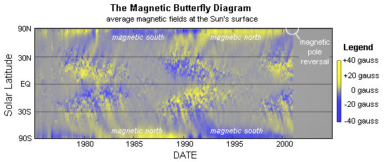
Hathaway noticed the latest polar reversal in a “magnetic butterfly
diagram”. Using data collected by astronomers at the U.S. National
Solar Observatory on Kitt Peak, he plotted the Sun’s average
magnetic field, day by day, as a function of solar latitude and time
from 1975 through the present. The result is a sort of strip chart
recording that reveals evolving magnetic patterns on the Sun’s
surface. “We call it a butterfly diagram,” he says, “because
sunspots make a pattern in this plot that looks like the wings of a
butterfly.”
In the butterfly diagram, pictured below, the Sun’s polar fields
appear as strips of uniform color near 90 degrees latitude. When the
colors change (in this case from blue to yellow or vice versa) it
means the polar fields have switched signs. The ongoing changes are
not confined to the space immediately around our star, Hathaway
added. The Sun’s magnetic field envelops the entire solar system in
a bubble that scientists call the “heliosphere”. The heliosphere
extends 50 to 100 astronomical units (AU) beyond the orbit of Pluto.
Inside it is the solar system— outside is interstellar space.
“Changes in the Sun’s magnetic field are carried outward through the
heliosphere by the solar wind,” explains Steve Suess, another solar
physicist at the Marshall Space Flight Center. “It takes about a
year for disturbances to propagate all the way from the Sun to the
outer bounds of the heliosphere.” Because the Sun rotates (once
every 27 days) solar magnetic fields corkscrew outwards in the shape
of an Archimedian spiral. Far above the poles the magnetic fields
twist around like a child’s Slinky toy.
Because of all the twists and turns, “the impact of the field
reversal on the heliosphere is complicated,” says Hathaway. Sunspots
are sources of intense magnetic knots that spiral outwards even as
the dipole field vanishes. The heliosphere doesn’t simply wink out
of existence when the poles flip—there are plenty of complex
magnetic structures to fill the void.
Or so the theory goes…Researchers have never seen the magnetic flip
happen from the best possible point of view—that is, from the top
down. But now, the unique Ulysses spacecraft may give scientists a
reality check. Ulysses, an international joint venture of the
European Space Agency and NASA, was launched in 1990 to observe the
solar system from very high solar latitudes. Every six years the
spacecraft flies 2.2 AU over the Sun’s poles. No other probe travels
so far above the orbital plane of the planets.
“Ulysses just passed under the Sun’s south pole,” says
Suess, a
mission co-Investigator. “Now it will loop back and fly over the
north pole in the fall.” “This is the most important part of our
mission,” he says.
Ulysses last flew over the Sun’s poles in 1994
and 1996, during solar minimum, and the craft made several important
discoveries about cosmic rays, the solar wind, and more. “Now we get
to see the Sun’s poles during the other extreme: Solar Max. Our data
will cover a complete solar cycle.”
To learn more about the Sun’s changing magnetic field and how it is
generated, please visit “The Solar Dynamo”, a webpage prepared by
the NASA/Marshall solar research group. Updates from the Ulysses
spacecraft may be found on the Internet from JPL at
http://ulysses.jpl.nasa.gov/.
UNQUOTE
And fortunately, just in time for inclusion in this book, the
following article from New Scientist passed through the Fortean
Times Mailing List on 8 August 2003. This “dust storm” will last a
decade, or until 2013.
QUOTE
http://www.newscientist.com/news/news.jsp?id=ns99994021
Galactic Dust Storm Enters Solar System
By Stuart Clark
05 August 2003
The Sun’s shifting magnetic field is set to focus a decade-long
storm of galactic dust grains towards the inner Solar System,
including Earth. The effect this will have on our planet—if any—is
unknown. But some researchers have speculated that sustained periods
of cosmic dust bombardment might be related to ice ages and even
mass extinctions.
During the last decade, the magnetic field of the Sun acted like a
shield, deflecting the electrically charged galactic dust away from
the Solar System. However, the Sun’s regular cycle of activity
peaked in 2001.
As expected, its magnetic field then flipped over, so that south
became north and vice-versa. In this configuration, rather than
deflecting the galactic dust, the magnetic field should actually
channel the dust inwards. This pattern may have been repeated during
previous solar cycles but it is only now that astronomers are
beginning to have the data they need to prove it.
Cosmic Debris
The data come from the galactic dust grains impacts detected by
DUST, an experiment on the ESA/NASA mission Ulysses, which was
launched in 1990. The measurements, collected by ESA scientist
Markus Landgraf and colleagues at the Max-Planck-Institute in
Heidelberg, show that three times more galactic dust is now entering
the Solar System than during the 1990s.
The effects of space dust on the Earth are currently unknown, but
hotly debated. Every year, about 40,000 tonnes of cosmic debris fall
onto the Earth, much of it creating meteors.
Some researchers have suggested recently that high dust inputs into
the Earth’s atmosphere, sustained for centuries or longer, could be
responsible for ice ages and mass extinctions. Langraf is cautious
about such claims but told New Scientist:
“Everything in interplanetary space eventually affects the planets,
but exactly how is very speculative.”
High-Altitude Aircraft
He hopes Ulysses can provide some concrete data. “We get about two
dust detections a week. We need to observe from now until 2006 in
order to have enough data to see evidence of focusing,” he says.
This data could then be correlated with the results from
high-altitude aircraft experiments that routinely catch the space
dust falling onto Earth. Historical comparisons might also be
possible if deep polar ice cores are analysed for galactic dust.
At present, the
Ulysses mission is only funded until September 2004.
However, an extended mission is currently being considered.
UNQUOTE
Go Back
|